
| THIBODAUX MUNI THIBODAUX LA |
| |
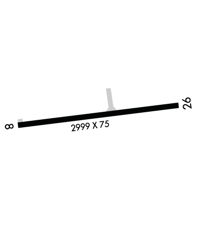
| Lat: N 2944.9 Long: W 09050.0 Elev: 9 Var: -02 Longest Runway: 2999 | ||
| CTAF: 122.8 | ||
| ||||||||||||||||||||||||||||||||||||||||||||
| ||||||||||||||||||||||||||||||||||||||||||||
| Rwy | Rwy | |||||||
| 2999x75 | 2999' | 2999x75 | 2909' | |||||
| Runway ID | Single Wheel | Double Wheel | Double Tandem Wheel | Dual Double Wheel |
| 08/26 | 6,000 | N/A | N/A | N/A |
| These numbers are Advisory and are not limits. The Airport Manager should have more accurate Weight Limits | ||||
 Airport Diagram might not be current. | |
| Facility Name: | THIBODAUX MUNI |
| City Name: | THIBODAUX |
| County: | TERREBONNE |
| State abbrev: | LA |
| State Name: | LOUISIANA |
| Ownership: | PUBLICLY OWNED |
| Use: | OPEN TO THE PUBLIC |
| Owner's Name: | CITY OF THIBODAUX |
| Address: | PO BOX 5418 |
| THIBODAUX, LA 70302-5418 | |
| Owner's Phone: | 985-446-7218 |
| Manager's Name: | SARAH ARCENAUX |
| Address: | PO BOX 5418 |
| THIBODAUX, LA 70302-5418 | |
| Phone: | 985-446-7208 |
| FAA Region: | SOUTHWEST |
| FAA Field Office: | LNM |
| Date | Sunrise | Sunset |
|---|---|---|
| 02/07/25 Friday | 6:50 | 17:46 |
| 02/08/25 Saturday | 6:49 | 17:47 |
| 02/09/25 Sunday | 6:48 | 17:48 |
| 02/10/25 Monday | 6:47 | 17:48 |
| 02/11/25 Tuesday | 6:46 | 17:49 |
| 02/12/25 Wednesday | 6:46 | 17:50 |
| 02/13/25 Thursday | 6:45 | 17:51 |
| 02/14/25 Friday | 6:44 | 17:52 |
| 02/15/25 Saturday | 6:43 | 17:52 |
| 02/16/25 Sunday | 6:42 | 17:53 |
| 02/17/25 Monday | 6:41 | 17:54 |
| 02/18/25 Tuesday | 6:40 | 17:55 |
| 02/19/25 Wednesday | 6:40 | 17:55 |
| 02/20/25 Thursday | 6:39 | 17:56 |
| Airport Attendance Schedule | 7 Days A Week 0800-1700; FOR ARPT ATND AFT HRS CALL 985-209-4697. |
| Airport Status | OPERATIONAL (This Status can change at any time - please check NOTAMS) |
| Airport Lighting Schedule | REIL RWY 08/26; MIRL RWY 08/26 PRESET LOW INTST; TO INCR INTST ACTVT - CTAF. |
| Airport Storage Available | Tie Downs |
| Extra Services Available | Crop Dusting, Annual Surveying |
| Wind Indicator | YES - (lighted) |
| Control Tower | NO |
| CTAF Frequency | 122.800 |
| Unicom Frequency | 122.800 |
| Rotating Beacon Color | WG |
| Segmented Circle | NO |
| Landing Fee | NO |
| Airport Inspected | STATE - performed by STATE AERONAUTICAL PERSONNEL |
| Inspection Date | 07/19/2023 |
| Type of Fuel Available | Grade 100LL; -10100LL FUEL AVBL BY APPT CALL 985-209-4697 |
| Airframe Repair Service | MINOR |
| Power Plant Repair Service | MINOR |
| Latitude | N2944.9 |
| Longitude | W09050.0 (ESTIMATED) |
| Arpt Elevation | 9ft (SURVEYED) |
| Magnetic Variation | 02E |
| 3 miles S | of THIBODAUX |
| Traffic Pattern Altitude | |
| Sectional Chart | NEW ORLEANS |
| Operations (Reported) | Yearly | Avg. Daily |
|---|---|---|
| General Aviation Transient | 0 | 0 |
| General Aviation Local | 0 | 0 |
| Air Taxi | 0 | 0 |
| Commerical | 0 | 0 |
| Commuter | 0 | 0 |
| Military | 0 | 0 |
| Aircraft based on Field | |
|---|---|
| General Aviation Singles | 0 |
| General Aviation Multi | 0 |
| Jet Aircraft | 0 |
| General Aviation Helicopters | 0 |
| Military Aircraft | 0 |
| Gliders | 0 |
| Ultralights | 0 |
| FSS on field | NO |
| FSS tie-in | DE RIDDER |
| FSS Phone | 1-800-WX-BRIEF |
| Who issues Notams | DRI |
| Notam D service at airport | YES |
| ARTCC Name | HOUSTON |
| Airport Certification | |
| Aircraft Rescue & Firefighting Index | None |
| Airport of Entry | No |
| Custom Landing Rights | No |
| Joint Civil/Military | No |
| Military Landing rights | No |
| NATIONAL PLAN OF INTEGRATED AIRPORT SYSTEMS (NPIAS) |
| THIS AIRPORT HAS BEEN SURVEYED BY THE NATIONAL GEODETIC SURVEY. |
| RWY 08/26 AGRICULTURE WASHDOWN PAD 500 FT NORTH OF RWY AT MIDFLD. |
| FOR CD CTC NEW ORLEANS APCH AT 504-471-4350. |
| TREES 60 FT TALL; 160 FT NORTH AND SOUTH OF CNTRLN PENT THE 7:1 TRSNL SLP RWY 08. |
| WILDLIFE ON OR NEAR THE RWY SAFETY AREA |
Airport Communications & Frequencies:
| ||||||||||||||
| Runway: 08 | Runway: 26 | ||
| Mag heading: | 82° | Mag heading: | 262° |
| Rwy Slope: | .07% Up | Rwy Slope: | -.07% Down |
| Approach: | Approach: | ||
| Pattern: | Left Traffic | Pattern: | Left Traffic |
| Markings: | NONPRECISION INSTRUMENT | Markings: | NONPRECISION INSTRUMENT |
| Marking Condition: | FAIR | Marking Condition: | FAIR |
| Arresting Dev: | Arresting Dev: | ||
| Lat & Long: | N2944.8 W09050.3 | Lat. & Long.: | N2944.9 W09049.7 |
| Elev: | 7.0 ft. MSL | Elev: | 9.0 ft. MSL |
| TCH: | TCH: | ||
| Visual Glide Path: | Visual Glide Path: | ||
| Displaced Threshold: | No | Displaced Threshold: | 90 feet |
| Touchdown Zone: | YES | Touchdown Zone: | YES |
| Touchdown Elev.: | 9.0 feet | Touchdown Elev.: | 9.0 feet |
| Visual Glide Slope: | Visual Glide Slope: | ||
| RVR Equipment: | RVR Equipment: | ||
| RVV Equipment: | NO | RVV Equipment: | NO |
| Approach Lights: | Approach Lights: | ||
| REIL: | YES | REIL: | YES |
| Centerline Lights: | NO | Centerline Lights: | NO |
| Touchdown lights: | NO | Touchdown lights: | NO |
| Runway Category: | Runway with a Non-precision Approach | Runway Category: | Runway with a Visual Approach |
| Declared Distances: | Declared Distances: | ||
| Obstructions: | TREES | Obstructions: | TREES |
| Marked: | NOT Marked/Lighted | Marked: | NOT Marked/Lighted |
| Clearance slope: | 5:1 | Clearance slope: | 21:1; APCH RATIO 14:1 TO DSPLCD THR. |
| Obstruction height: | 79 feet AGL | Obstruction height: | 73 feet AGL |
| Dist. from runway: | 637 feet | Dist. from runway: | 1754 feet |
| Centerline offset: | 132 right of centerline | Centerline offset: | 130B |
| Comments: | Comments: |
Thanks for using FltPlan.com
all rights reserved © 1999-2025 by Flight Plan LLC
