
| LAGRANGE-CALLAWAY LAGRANGE GA |
| |
| Lat: N 3300.5 Long: W 08504.4 Elev: 694 Var: +04 Longest Runway: 6499 | ||
| Clr Del: 119.25 AWOS: 126.32 CTAF: 122.97 | ||
| ||||||||||||||||||||||||||||||||||||||||||||||||||||||||||||||||||||
| ||||||||||||||||||||||||||||||||||||||||||||||||||||||||||||||||||||
| ||||||||||||||||||||||||||||||||||||||||||||||||||||||||||||||||||||
| Rwy | Rwy | |||||||
| 5000x100 | 5000' | 5000x100 | 5000' | |||||
| 6499x100 | 6499' | 6499x100 | 6499' | 110.90 - 310° | ||||
| Runway ID | Single Wheel | Double Wheel | Double Tandem Wheel | Dual Double Wheel |
| 03/21 | 45,000 | 50,000 | N/A | N/A |
| 13/31 | 75,000 | 100,000 | 100,000 | N/A |
| These numbers are Advisory and are not limits. The Airport Manager should have more accurate Weight Limits | ||||
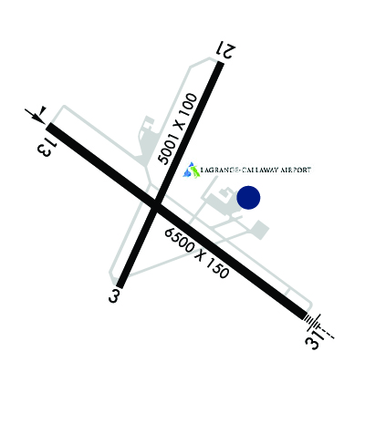 Airport Diagram might not be current. | |
| Facility Name: | LAGRANGE/CALLAWAY |
| City Name: | LAGRANGE |
| County: | TROUP |
| State abbrev: | GA |
| State Name: | GEORGIA |
| Ownership: | PUBLICLY OWNED |
| Use: | OPEN TO THE PUBLIC |
| Owner's Name: | CITY OF LA GRANGE & TROUP CO |
| Address: | TROUP COUNTY, 100 RIDLEY AVE, CITY, 200 RIDLEY AVE |
| LAGRANGE, GA 30241 | |
| Owner's Phone: | 706-883-1610 |
| Manager's Name: | TROY ANDERSON |
| Address: | 200 AIRPORT PARKWAY |
| LAGRANGE, GA 30240 | |
| Phone: | 706-616-1553 |
| FAA Region: | SOUTHERN |
| FAA Field Office: | ATL |

| Date | Sunrise | Sunset |
|---|---|---|
| 10/05/24 Saturday | 7:38 | 19:19 |
| 10/06/24 Sunday | 7:39 | 19:17 |
| 10/07/24 Monday | 7:39 | 19:16 |
| 10/08/24 Tuesday | 7:40 | 19:15 |
| 10/09/24 Wednesday | 7:41 | 19:13 |
| 10/10/24 Thursday | 7:41 | 19:12 |
| 10/11/24 Friday | 7:42 | 19:11 |
| 10/12/24 Saturday | 7:43 | 19:10 |
| 10/13/24 Sunday | 7:44 | 19:09 |
| 10/14/24 Monday | 7:44 | 19:07 |
| 10/15/24 Tuesday | 7:45 | 19:06 |
| 10/16/24 Wednesday | 7:46 | 19:05 |
| 10/17/24 Thursday | 7:47 | 19:04 |
| 10/18/24 Friday | 7:47 | 19:03 |
| Airport Attendance Schedule | MON-FRI 0800-1800, SAT-SUN 0900-1700 |
| Airport Status | OPERATIONAL (This Status can change at any time - please check NOTAMS) |
| Airport Lighting Schedule | ACTVT MALSR RWY 31; HIRL RWY 13/31; TWY LGTS - CTAF. |
| Airport Storage Available | Tie Downs |
| Extra Services Available | Flight Instruction, Aircraft Rental |
| Wind Indicator | YES - (lighted) |
| Control Tower | NO |
| CTAF Frequency | 122.975 |
| Unicom Frequency | 122.975 |
| Rotating Beacon Color | WG |
| Segmented Circle | YES |
| Landing Fee | NO |
| Airport Inspected | STATE - performed by STATE AERONAUTICAL PERSONNEL |
| Inspection Date | 02/08/2024 |
| Type of Fuel Available | Grade 100LL, JET A; -10FUEL 24 HR CREDIT CARD SVC AVBL. |
| Airframe Repair Service | MAJOR |
| Power Plant Repair Service | MAJOR |
| Latitude | N3300.5 |
| Longitude | W08504.4 (ESTIMATED) |
| Arpt Elevation | 693ft (SURVEYED) |
| Magnetic Variation | 04W |
| 3 miles SW | of LAGRANGE |
| Traffic Pattern Altitude | 1007 |
| Sectional Chart | ATLANTA |
| Operations (Reported) | Yearly | Avg. Daily |
|---|---|---|
| General Aviation Transient | 0 | 0 |
| General Aviation Local | 0 | 0 |
| Air Taxi | 0 | 0 |
| Commerical | 0 | 0 |
| Commuter | 0 | 0 |
| Military | 0 | 0 |
| Aircraft based on Field | |
|---|---|
| General Aviation Singles | 0 |
| General Aviation Multi | 0 |
| Jet Aircraft | 0 |
| General Aviation Helicopters | 0 |
| Military Aircraft | 0 |
| Gliders | 0 |
| Ultralights | 0 |
| FSS on field | NO |
| FSS tie-in | MACON |
| FSS Phone | 1-800-WX-BRIEF |
| Who issues Notams | LGC |
| Notam D service at airport | YES |
| ARTCC Name | ATLANTA |
| Airport Certification | |
| Aircraft Rescue & Firefighting Index | None |
| Airport of Entry | No |
| Custom Landing Rights | No |
| Joint Civil/Military | No |
| Military Landing rights | YES |
| NATIONAL PLAN OF INTEGRATED AIRPORT SYSTEMS (NPIAS) |
| GRANT AGREEMENTS UNDER FAAP/ADAP/AIP |
| ASSURANCES PURSUANT TO TITLE VI, CIVIL RIGHTS ACT OF 1964 |
| AGREEMENT UNDER DLAND OR DCLA HAS EXPIRED. |
| DEER ON & INVOF ARPT. |
Airport Communications & Frequencies:
| |||||||||||||||||||
| Runway: 03 | Runway: 21 | ||
| Mag heading: | 28° | Mag heading: | 208° |
| Rwy Slope: | .31% Up | Rwy Slope: | -.31% Down |
| Approach: | Approach: | ||
| Pattern: | Left Traffic | Pattern: | Left Traffic |
| Markings: | NONPRECISION INSTRUMENT | Markings: | NONPRECISION INSTRUMENT |
| Marking Condition: | GOOD | Marking Condition: | GOOD |
| Arresting Dev: | Arresting Dev: | ||
| Lat & Long: | N3300.3 W08504.6 | Lat. & Long.: | N3301.0 W08504.2 |
| Elev: | 677.9 ft. MSL | Elev: | 693.6 ft. MSL |
| TCH: | TCH: | ||
| Visual Glide Path: | Visual Glide Path: | ||
| Displaced Threshold: | No | Displaced Threshold: | No |
| Touchdown Zone: | YES | Touchdown Zone: | YES |
| Touchdown Elev.: | 684.2 feet | Touchdown Elev.: | 693.6 feet |
| Visual Glide Slope: | Visual Glide Slope: | ||
| RVR Equipment: | RVR Equipment: | ||
| RVV Equipment: | NO | RVV Equipment: | NO |
| Approach Lights: | Approach Lights: | ||
| REIL: | NO | REIL: | NO |
| Centerline Lights: | NO | Centerline Lights: | NO |
| Touchdown lights: | NO | Touchdown lights: | NO |
| Runway Category: | Runway with a Non-precision Approach having visibility minimums greater than 3/4 mile | Runway Category: | Runway with a Visual Approach |
| Declared Distances: | Declared Distances: | ||
| Obstructions: | TREES | Obstructions: | TREES |
| Marked: | NOT Marked/Lighted | Marked: | NOT Marked/Lighted |
| Clearance slope: | 14:1 | Clearance slope: | 11:1 |
| Obstruction height: | 81 feet AGL | Obstruction height: | 72 feet AGL |
| Dist. from runway: | 1334 feet | Dist. from runway: | 992 feet |
| Centerline offset: | 246 left of centerline | Centerline offset: | 230 feet right of centerline |
| Comments: | Comments: |
| Runway: 13 | Runway: 31 | ||
| Mag heading: | 131° | Mag heading: | 310° |
| Rwy Slope: | -.19% Down | Rwy Slope: | .19% Up |
| Approach: | Approach: | ILS | |
| Pattern: | Left Traffic | Pattern: | Left Traffic |
| Markings: | PRECISION INSTRUMENT | Markings: | PRECISION INSTRUMENT |
| Marking Condition: | GOOD | Marking Condition: | GOOD |
| Arresting Dev: | Arresting Dev: | ||
| Lat & Long: | N3300.8 W08504.9 | Lat. & Long.: | N3300.2 W08503.9 |
| Elev: | 687.7 ft. MSL | Elev: | 675.3 ft. MSL |
| TCH: | 41 ft. AGL | TCH: | 40 ft. AGL |
| Visual Glide Path: | 3.00 degrees | Visual Glide Path: | 3.00 degrees |
| Displaced Threshold: | No | Displaced Threshold: | No |
| Touchdown Zone: | YES | Touchdown Zone: | YES |
| Touchdown Elev.: | 687.7 feet | Touchdown Elev.: | 680.6 feet |
| Visual Glide Slope: | 4-Light PAPI on LEFT side of Runway | Visual Glide Slope: | 4-Light PAPI on RIGHT side of Runway |
| RVR Equipment: | RVR Equipment: | ||
| RVV Equipment: | NO | RVV Equipment: | NO |
| Approach Lights: | Approach Lights: | MALSR - 1,400 foot medium intensity approach lighting system with runway alignment indicator lights | |
| REIL: | YES | REIL: | NO |
| Centerline Lights: | NO | Centerline Lights: | NO |
| Touchdown lights: | NO | Touchdown lights: | NO |
| Runway Category: | Runway with a Non-precision Approach having visibility minimums greater than 3/4 mile | Runway Category: | Precision Instrument Runway |
| Declared Distances: | Declared Distances: | ||
| Obstructions: | TREES | Obstructions: | TREES |
| Marked: | NOT Marked/Lighted | Marked: | NOT Marked/Lighted |
| Clearance slope: | 18:1 | Clearance slope: | 38:1 |
| Obstruction height: | 123 feet AGL | Obstruction height: | 143 feet AGL |
| Dist. from runway: | 2414 feet | Dist. from runway: | 5634 feet |
| Centerline offset: | 675 right of centerline | Centerline offset: | 592 feet right of centerline |
| Comments: | Comments: |
Thanks for using FltPlan.com
all rights reserved © 1999-2024 by Flight Plan LLC


