
| VANCE BRAND LONGMONT CO |
| |
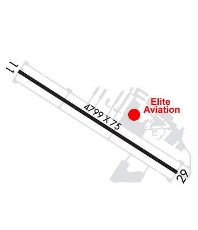
| Lat: N 4009.9 Long: W 10509.8 Elev: 5055 Var: -10 Longest Runway: 4799 | ||
| AWOS: 120.0 CTAF: 122.97 | ||
| |||||||||||||||||||||||||||||||
| |||||||||||||||||||||||||||||||
| |||||||||||||||||||||||||||||||
| Rwy | Rwy | |||||||
| 4799x75 | 4799' | 4799x75 | 4799' | |||||
| Runway ID | Single Wheel | Double Wheel | Double Tandem Wheel | Dual Double Wheel |
| 11/29 | 30,000 | N/A | N/A | N/A |
| These numbers are Advisory and are not limits. The Airport Manager should have more accurate Weight Limits | ||||
 Airport Diagram might not be current. | |
| Facility Name: | VANCE BRAND |
| City Name: | LONGMONT |
| County: | BOULDER |
| State abbrev: | CO |
| State Name: | COLORADO |
| Ownership: | PUBLICLY OWNED |
| Use: | OPEN TO THE PUBLIC |
| Owner's Name: | CITY OF LONGMONT |
| Address: | 350 KIMBARK ST |
| LONGMONT, CO 80501 | |
| Owner's Phone: | 303-651-8431 |
| Manager's Name: | DAVID SLAYTER |
| Address: | 229 AIRPORT ROAD |
| LONGMONT, CO 80503 | |
| Phone: | 303-651-8431 |
| FAA Region: | NORTHWEST MOUNTAIN |
| FAA Field Office: | DEN |

| Date | Sunrise | Sunset |
|---|---|---|
| 09/24/21 Friday | 6:50 | 18:55 |
| 09/25/21 Saturday | 6:51 | 18:53 |
| 09/26/21 Sunday | 6:52 | 18:51 |
| 09/27/21 Monday | 6:53 | 18:50 |
| 09/28/21 Tuesday | 6:54 | 18:48 |
| 09/29/21 Wednesday | 6:55 | 18:46 |
| 09/30/21 Thursday | 6:56 | 18:45 |
| 10/01/21 Friday | 6:57 | 18:43 |
| 10/02/21 Saturday | 6:58 | 18:42 |
| 10/03/21 Sunday | 6:59 | 18:40 |
| 10/04/21 Monday | 7:00 | 18:38 |
| 10/05/21 Tuesday | 7:01 | 18:37 |
| 10/06/21 Wednesday | 7:02 | 18:35 |
| 10/07/21 Thursday | 7:03 | 18:34 |
| Airport Attendance Schedule | 7 Days A Week DALGT |
| Airport Status | OPERATIONAL (This Status can change at any time - please check NOTAMS) |
| Airport Lighting Schedule | ACTVT MIRL RY 11/29 AND VASI RY 11/29 - CTAF. |
| Airport Storage Available | Tie Downs |
| Extra Services Available | Charter, Flight Instruction, Parachute Jumping, Aircraft Rental, Aircraft Sales |
| Wind Indicator | YES - (lighted) |
| Control Tower | NO |
| CTAF Frequency | 122.975 |
| Unicom Frequency | 122.975 |
| Rotating Beacon Color | CLEAR-GREEN (Light Land Airport) |
| Segmented Circle | YES |
| Landing Fee | NO |
| Airport Inspected | STATE - performed by STATE AERONAUTICAL PERSONNEL |
| Inspection Date | 07/29/2019 |
| Type of Fuel Available | Grade 100LL, JET A (freeze point -40C)MOGAS |
| Airframe Repair Service | MAJOR |
| Power Plant Repair Service | MAJOR |
| Latitude | N4009.9 |
| Longitude | W10509.8 (ESTIMATED) |
| Arpt Elevation | 5055ft (SURVEYED) |
| Magnetic Variation | 10E |
| 3 miles SW | of LONGMONT |
| Traffic Pattern Altitude | |
| Sectional Chart | CHEYENNE |
| Operations (Reported) | Yearly | Avg. Daily |
|---|---|---|
| General Aviation Transient | 26546 | 73 |
| General Aviation Local | 61545 | 169 |
| Air Taxi | 0 | 0 |
| Commerical | 0 | 0 |
| Commuter | 0 | 0 |
| Military | 396 | 1 |
| Aircraft based on Field | |
|---|---|
| General Aviation Singles | 216 |
| General Aviation Multi | 10 |
| Jet Aircraft | 4 |
| General Aviation Helicopters | 4 |
| Military Aircraft | 0 |
| Gliders | 6 |
| Ultralights | 1 |
| FSS on field | NO |
| FSS tie-in | DENVER |
| FSS Phone | 1-800-WX-BRIEF |
| Who issues Notams | DEN |
| Notam D service at airport | YES |
| ARTCC Name | DENVER |
| Airport Certification | |
| Aircraft Rescue & Firefighting Index | None |
| Airport of Entry | No |
| Custom Landing Rights | No |
| Joint Civil/Military | No |
| Military Landing rights | YES |
| NATIONAL PLAN OF INTEGRATED AIRPORT SYSTEMS (NPIAS) |
| GRANT AGREEMENTS UNDER FAAP/ADAP/AIP |
| ASSURANCES PURSUANT TO TITLE VI, CIVIL RIGHTS ACT OF 1964 |
| FOR CD CTC DENVER APCH AT 303-342-1916. |
| ULTRALIGHT & HELICOPTER ACTIVITY ON & INVOF ARPT. |
| RY 11 HAS -7 FT DITCH 420 FT AND 900 FT FM THLD ON EXTDD THLD. |
| RY 29 HAS +15 FT HWY 702 FT FM THLD; +25 TO 35 FT BLDGS/TANKS APROXLY 1300 FT L OF THLD. |
| NOISE ABATEMENT PROCEDURES IN EFFECT CTC ARPT MANAGER 303-651-8431. |
| PARAJUMPING ON AND IN VICINITY OF ARPT PRIMARILY S OF RY, AVOID OVERFLIGHTS MID FIELD. |
Airport Communications & Frequencies:
| ||||||||||||||
| Runway: 11 | Runway: 29 | ||
| Mag heading: | 113° | Mag heading: | 293° |
| Rwy Slope: | -.50% Down | Rwy Slope: | .50% Up |
| Approach: | Approach: | ||
| Pattern: | Left Traffic | Pattern: | Left Traffic |
| Markings: | BASIC | Markings: | NONPRECISION INSTRUMENT |
| Marking Condition: | FAIR | Marking Condition: | FAIR |
| Arresting Dev: | Arresting Dev: | ||
| Lat & Long: | N4010.1 W10510.3 | Lat. & Long.: | N4009.7 W10509.4 |
| Elev: | 5055.3 ft. MSL | Elev: | 5031.1 ft. MSL |
| TCH: | 24 ft. AGL | TCH: | 35 ft. AGL |
| Visual Glide Path: | 3.00 degrees | Visual Glide Path: | 3.00 degrees |
| Displaced Threshold: | No | Displaced Threshold: | No |
| Touchdown Zone: | YES | Touchdown Zone: | YES |
| Touchdown Elev.: | 5055.3 feet | Touchdown Elev.: | 5047.4 feet |
| Visual Glide Slope: | 2-Box VASI on LEFT side of Runway; VASI UNUSLB BYD 3.9 NM. VASI DOES NOT PRVD OBST CLNC BYD 3.9 NM FROM THLD. | Visual Glide Slope: | 2-Box VASI on LEFT side of Runway |
| RVR Equipment: | RVR Equipment: | ||
| RVV Equipment: | NO | RVV Equipment: | NO |
| Approach Lights: | Approach Lights: | ||
| REIL: | NO | REIL: | NO |
| Centerline Lights: | NO | Centerline Lights: | NO |
| Touchdown lights: | NO | Touchdown lights: | NO |
| Runway Category: | Runway with a Visual Approach | Runway Category: | Runway with a Non-precision Approach having visibility minimums greater than 3/4 mile |
| Declared Distances: | Declared Distances: | ||
| Obstructions: | TREE | Obstructions: | ROAD |
| Marked: | NOT Marked/Lighted | Marked: | NOT Marked/Lighted |
| Clearance slope: | 19:1 | Clearance slope: | 23:1 |
| Obstruction height: | 31 feet AGL | Obstruction height: | 8 feet AGL |
| Dist. from runway: | 819 feet | Dist. from runway: | 388 feet |
| Centerline offset: | 29 right of centerline | Centerline offset: | |
| Comments: | Comments: |
Thanks for using FltPlan.com
all rights reserved © 1999-2021 by Flight Plan LLC


