
| MIDDLE GEORGIA RGNL MACON GA |
| |
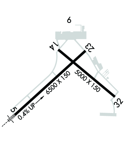
| Lat: N 3241.6 Long: W 08339.0 Elev: 354 Var: +06 Longest Runway: 6500 | ||
| Dept. ATIS: 120.77 Arr. ATIS: 120.77 AWOS: 120.77 Ground: 121.65 Tower: 128.2 | ||
| ||||||||||||||||||||||||||||||||||||||||||||
| ||||||||||||||||||||||||||||||||||||||||||||
| ||||||||||||||||||||||||||||||||||||||||||||
| Rwy | Rwy | |||||||
| 6500x150 | 6500' | 109.50 - 053° | 6500x150 | 6500' | ||||
| 5000x150 | 5000' | 5000x150 | 5000' | |||||
| Runway ID | Single Wheel | Double Wheel | Double Tandem Wheel | Dual Double Wheel |
| 05/23 | 80,000 | 128,000 | 237,000 | N/A |
| 14/32 | 44,000 | 65,000 | 110,000 | N/A |
| These numbers are Advisory and are not limits. The Airport Manager should have more accurate Weight Limits | ||||
 Airport Diagram might not be current. | |
| Facility Name: | MIDDLE GEORGIA RGNL |
| City Name: | MACON |
| County: | BIBB |
| State abbrev: | GA |
| State Name: | GEORGIA |
| Ownership: | PUBLICLY OWNED |
| Use: | OPEN TO THE PUBLIC |
| Owner's Name: | MACON-BIBB COUNTY |
| Address: | CITY HALL |
| MACON, GA 31202 | |
| Owner's Phone: | 478-788-3760 |
| Manager's Name: | BLAKE ROY |
| Address: | 1000 TERMINAL DR |
| MACON, GA 31297 | |
| Phone: | 478-803-0460 |
| FAA Region: | SOUTHERN |
| FAA Field Office: | ATL |
| Date | Sunrise | Sunset |
|---|---|---|
| 09/24/21 Friday | 7:24 | 19:29 |
| 09/25/21 Saturday | 7:25 | 19:28 |
| 09/26/21 Sunday | 7:25 | 19:26 |
| 09/27/21 Monday | 7:26 | 19:25 |
| 09/28/21 Tuesday | 7:27 | 19:24 |
| 09/29/21 Wednesday | 7:27 | 19:22 |
| 09/30/21 Thursday | 7:28 | 19:21 |
| 10/01/21 Friday | 7:29 | 19:20 |
| 10/02/21 Saturday | 7:29 | 19:18 |
| 10/03/21 Sunday | 7:30 | 19:17 |
| 10/04/21 Monday | 7:31 | 19:16 |
| 10/05/21 Tuesday | 7:31 | 19:14 |
| 10/06/21 Wednesday | 7:32 | 19:13 |
| 10/07/21 Thursday | 7:33 | 19:12 |
| Airport Attendance Schedule | 7 Days A Week 0600-2200; FOR SVC AFT HRS CTC LOWE AVIATION - 478-788-3491. |
| Airport Status | OPERATIONAL (This Status can change at any time - please check NOTAMS) |
| Airport Lighting Schedule | ACTIVATE HIRL RY 05/23, MALSR RY 05, REIL RY 23 & RY 32, MIRL RY 14/32 & TWY LGTS - CTAF. |
| Airport Storage Available | Tie Downs, Hanger |
| Extra Services Available | Air Freight, Air Ambulance, Charter, Flight Instruction, Aircraft Rental, Aircraft Sales |
| Wind Indicator | YES - (lighted) |
| Control Tower | YES |
| CTAF Frequency | 128.200 |
| Unicom Frequency | 122.950 |
| Rotating Beacon Color | CLEAR-GREEN (Light Land Airport) |
| Segmented Circle | YES |
| Landing Fee | NO |
| Airport Inspected | FEDERAL - performed by FAA AIRPORTS FIELD PERSONNEL |
| Inspection Date | 04/27/2021 |
| Type of Fuel Available | Grade 100LL, JET A (freeze point -40C) |
| Airframe Repair Service | MAJOR |
| Power Plant Repair Service | MAJOR |
| Latitude | N3241.6 |
| Longitude | W08339.0 (ESTIMATED) |
| Arpt Elevation | 354ft (SURVEYED) |
| Magnetic Variation | 06W |
| 9 miles S | of MACON |
| Traffic Pattern Altitude | |
| Sectional Chart | ATLANTA |
| Operations (Reported) | Yearly | Avg. Daily |
|---|---|---|
| General Aviation Transient | 9401 | 26 |
| General Aviation Local | 2892 | 8 |
| Air Taxi | 1754 | 5 |
| Commerical | 89 | 0 |
| Commuter | 0 | 0 |
| Military | 2822 | 8 |
| Aircraft based on Field | |
|---|---|
| General Aviation Singles | 45 |
| General Aviation Multi | 27 |
| Jet Aircraft | 9 |
| General Aviation Helicopters | 1 |
| Military Aircraft | 0 |
| Gliders | 0 |
| Ultralights | 0 |
| FSS on field | NO |
| FSS tie-in | MACON |
| FSS Phone | 1-800-WX-BRIEF |
| Who issues Notams | MCN |
| Notam D service at airport | YES |
| ARTCC Name | ATLANTA |
| Airport Certification | AIRPORT RECEIVING SCHEDULED AIR CARRIER SERVICE FROM CARRIERS CERTIFICATED BY THE CIVIL AERONAUTICS BOARD |
| Aircraft Rescue & Firefighting Index | AIRPORT HAS A CERTIFICATE UNDER CFR PART 139 |
| Airport of Entry | No |
| Custom Landing Rights | No |
| Joint Civil/Military | No |
| Military Landing rights | YES |
| NATIONAL PLAN OF INTEGRATED AIRPORT SYSTEMS (NPIAS) |
| GRANT AGREEMENTS UNDER FAAP/ADAP/AIP |
| SURPLUS PROPERTY AGREEMENT UNDER PUBLIC LAW 289 |
| ASSURANCES PURSUANT TO TITLE VI, CIVIL RIGHTS ACT OF 1964 |
| ROBINS AFB CLASS D AIRSPACE .4 MI SE OF DEP END RY 14. VFR ACFT DEP RY 14 BTN 2000-0800 ARE ADVISED TO CTC ROBINS ATCT 133.22/320.1 PRIOR TO DEP. |
| DEER ON & INVOF ARPT. |
| PAEW ADJ TO THE MOVEMENT AREAS FROM MARCH 1 TO NOV 1 FOR GRASS CUTTING. |
| FOR CD IF UNA TO CTC ON FSS FREQ, CTC ATLANTA APCH AT 678-364-6132, WHEN ATCT CLSD CTC ATLANTA ARTCC AT 770-210-7692. |
Airport Communications & Frequencies:
| |||||||||||||||||||||||||||||||
| Runway: 05 | Runway: 23 | ||
| Mag heading: | 54° | Mag heading: | 234° |
| Rwy Slope: | .36% Up | Rwy Slope: | -.36% Down |
| Approach: | ILS | Approach: | |
| Pattern: | Left Traffic | Pattern: | Right Traffic |
| Markings: | PRECISION INSTRUMENT | Markings: | NONPRECISION INSTRUMENT |
| Marking Condition: | GOOD | Marking Condition: | GOOD |
| Arresting Dev: | Arresting Dev: | ||
| Lat & Long: | N3241.2 W08339.6 | Lat. & Long.: | N3241.9 W08338.7 |
| Elev: | 331.0 ft. MSL | Elev: | 354.2 ft. MSL |
| TCH: | TCH: | 67 ft. AGL | |
| Visual Glide Path: | Visual Glide Path: | 3.00 degrees | |
| Displaced Threshold: | No | Displaced Threshold: | No |
| Touchdown Zone: | YES | Touchdown Zone: | YES |
| Touchdown Elev.: | 344.3 feet | Touchdown Elev.: | 354.2 feet |
| Visual Glide Slope: | Visual Glide Slope: | 4-Light PAPI on LEFT side of Runway | |
| RVR Equipment: | TOUCHDOWN | RVR Equipment: | ROLLOUT |
| RVV Equipment: | NO | RVV Equipment: | NO |
| Approach Lights: | MALSR - 1,400 foot medium intensity approach lighting system with runway alignment indicator lights | Approach Lights: | |
| REIL: | NO | REIL: | YES |
| Centerline Lights: | NO | Centerline Lights: | NO |
| Touchdown lights: | NO | Touchdown lights: | NO |
| Runway Category: | Precision Instrument Runway | Runway Category: | Runway with a Non-precision Approach having visibility minimums greater than 3/4 mile |
| Declared Distances: | TORA:6501' TODA:6501' ASDA:6221' LDA:6221' | Declared Distances: | TORA:6501' TODA:6501' ASDA:6426' LDA:6426' |
| Obstructions: | TREES | Obstructions: | TREES |
| Marked: | NOT Marked/Lighted | Marked: | NOT Marked/Lighted |
| Clearance slope: | 50:1 | Clearance slope: | 20:1 |
| Obstruction height: | 27 feet AGL | Obstruction height: | 47 feet AGL |
| Dist. from runway: | 1540 feet | Dist. from runway: | 1140 feet |
| Centerline offset: | 450 right of centerline | Centerline offset: | 350 feet right of centerline |
| Comments: | Comments: |
| Runway: 14 | Runway: 32 | ||
| Mag heading: | 136° | Mag heading: | 316° |
| Rwy Slope: | -.17% Down | Rwy Slope: | .17% Up |
| Approach: | Approach: | ||
| Pattern: | Right Traffic | Pattern: | Left Traffic |
| Markings: | NONPRECISION INSTRUMENT | Markings: | NONPRECISION INSTRUMENT |
| Marking Condition: | GOOD | Marking Condition: | GOOD |
| Arresting Dev: | Arresting Dev: | ||
| Lat & Long: | N3241.9 W08339.0 | Lat. & Long.: | N3241.4 W08338.3 |
| Elev: | 353.7 ft. MSL | Elev: | 345.3 ft. MSL |
| TCH: | TCH: | ||
| Visual Glide Path: | Visual Glide Path: | ||
| Displaced Threshold: | No | Displaced Threshold: | No |
| Touchdown Zone: | YES | Touchdown Zone: | YES |
| Touchdown Elev.: | 354.0 feet | Touchdown Elev.: | 351.4 feet |
| Visual Glide Slope: | Visual Glide Slope: | ||
| RVR Equipment: | RVR Equipment: | ||
| RVV Equipment: | NO | RVV Equipment: | NO |
| Approach Lights: | Approach Lights: | ||
| REIL: | NO | REIL: | YES |
| Centerline Lights: | NO | Centerline Lights: | NO |
| Touchdown lights: | NO | Touchdown lights: | NO |
| Runway Category: | Runway with a Non-precision Approach having visibility minimums greater than 3/4 mile | Runway Category: | Runway with a Non-precision Approach having visibility minimums greater than 3/4 mile |
| Declared Distances: | TORA:5000' TODA:5000' ASDA:5000' LDA:5000' | Declared Distances: | TORA:5000' TODA:5000' ASDA:5000' LDA:5000' |
| Obstructions: | TREES | Obstructions: | RR |
| Marked: | NOT Marked/Lighted | Marked: | NOT Marked/Lighted |
| Clearance slope: | 20:1 | Clearance slope: | 10:1 |
| Obstruction height: | 43 feet AGL | Obstruction height: | 32 feet AGL |
| Dist. from runway: | 1060 feet | Dist. from runway: | 525 feet |
| Centerline offset: | 50 left of centerline | Centerline offset: | 300 feet right of centerline |
| Comments: | Comments: |
Thanks for using FltPlan.com
all rights reserved © 1999-2021 by Flight Plan LLC
