
| CHARLES B. WHEELER DOWNTOWN KANSAS CITY MO |
| |
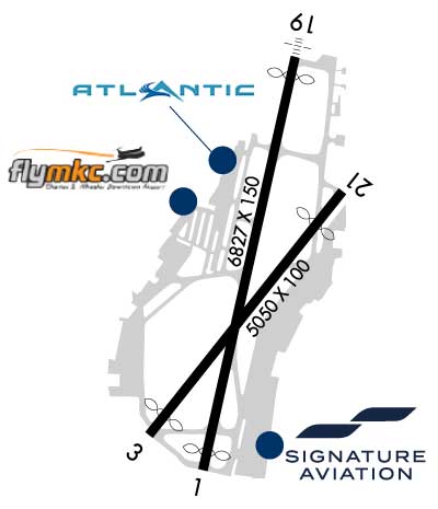
| Lat: N 3907.4 Long: W 09435.6 Elev: 757 Var: -01 Longest Runway: 6827 | ||
| Clr Del: 121.9 Dept. ATIS: 120.75 Arr. ATIS: 120.75 AWOS: 120.75 Ground: 121.9 Tower: 133.3 | ||

| |||||||||||||||||||||||||||||||||||||||||||||||||||||||||||||||||||||
| |||||||||||||||||||||||||||||||||||||||||||||||||||||||||||||||||||||
| |||||||||||||||||||||||||||||||||||||||||||||||||||||||||||||||||||||
| |||||||||||||||||||||||||||||||||||||||||||||||||||||||||||||||||||||
| |||||||||||||||||||||||||||||||||||||||||||||||||||||||||||||||||||||
| |||||||||||||||||||||||||||||||||||||||||||||||||||||||||||||||||||||
| FBOs at nearby airports who want your business: | |||||||||||||||||
| |||||||||||||||||
| |||||||||||||||||
| Rwy | Rwy | |||||||
| 6827x150 | 6528' | 6827x150 | 6526' | 109.90 - 191° | ||||
| 5050x100 | 4550' | 111.75 - 035° | 5050x100 | 4351' | ||||
| Runway ID | Single Wheel | Double Wheel | Double Tandem Wheel | Dual Double Wheel |
| 01/19 | 86,000 | 171,000 | 342,000 | N/A |
| 04/22 | 120,000 | 204,000 | 303,000 | 805,000 |
| These numbers are Advisory and are not limits. The Airport Manager should have more accurate Weight Limits | ||||
 Airport Diagram might not be current. | |
| Facility Name: | KANSAS CITY DOWNTOWN/WHEELER FLD |
| City Name: | KANSAS CITY |
| County: | CLAY |
| State abbrev: | MO |
| State Name: | MISSOURI |
| Ownership: | PUBLICLY OWNED |
| Use: | OPEN TO THE PUBLIC |
| Owner's Name: | CITY OF KANSAS CITY |
| Address: | 414 E. 12TH ST |
| KANSAS CITY, MO 64106 | |
| Owner's Phone: | 816-859-7601 |
| Manager's Name: | ROD DEWINKLER |
| Address: | 900 NW RICHARDS ROAD |
| KANSAS CITY, MO 64116 | |
| Phone: | 816-859-7610 |
| FAA Region: | CENTRAL |
| FAA Field Office: | NONE |
| Date | Sunrise | Sunset |
|---|---|---|
| 03/30/25 Sunday | 7:06 | 19:40 |
| 03/31/25 Monday | 7:05 | 19:41 |
| 04/01/25 Tuesday | 7:03 | 19:42 |
| 04/02/25 Wednesday | 7:02 | 19:43 |
| 04/03/25 Thursday | 7:00 | 19:44 |
| 04/04/25 Friday | 6:59 | 19:45 |
| 04/05/25 Saturday | 6:57 | 19:46 |
| 04/06/25 Sunday | 6:56 | 19:47 |
| 04/07/25 Monday | 6:54 | 19:48 |
| 04/08/25 Tuesday | 6:52 | 19:49 |
| 04/09/25 Wednesday | 6:51 | 19:50 |
| 04/10/25 Thursday | 6:49 | 19:51 |
| 04/11/25 Friday | 6:48 | 19:52 |
| 04/12/25 Saturday | 6:46 | 19:53 |
| Airport Attendance Schedule | CONTINUOUS |
| Airport Status | OPERATIONAL (This Status can change at any time - please check NOTAMS) |
| Airport Lighting Schedule | SS-SR |
| Airport Storage Available | Tie Downs, Hanger |
| Extra Services Available | Air Freight, Avionics, Cargo Handling, Charter, Flight Instruction, Aircraft Rental, Aircraft Sales, Annual Surveying |
| Wind Indicator | YES - (lighted) |
| Control Tower | YES |
| CTAF Frequency | |
| Unicom Frequency | 122.950 |
| Rotating Beacon Color | WG |
| Segmented Circle | NO |
| Landing Fee | NO |
| Airport Inspected | FEDERAL - performed by FAA AIRPORTS FIELD PERSONNEL |
| Inspection Date | 10/08/2024 |
| Type of Fuel Available | Grade 100LL, JET A (freeze point -40C); -10100LL SELF SVC AVBL 24 HRS WITH CREDIT CARD ONLY ON WEST SIDE NEAR GA TERMINAL. |
| Airframe Repair Service | MAJOR |
| Power Plant Repair Service | MAJOR |
| Latitude | N3907.4 |
| Longitude | W09435.6 (ESTIMATED) |
| Arpt Elevation | 756ft (SURVEYED) |
| Magnetic Variation | 01E |
| 0 miles NW | of KANSAS CITY |
| Traffic Pattern Altitude | |
| Sectional Chart | KANSAS CITY |
| Operations (Reported) | Yearly | Avg. Daily |
|---|---|---|
| General Aviation Transient | 0 | 0 |
| General Aviation Local | 0 | 0 |
| Air Taxi | 0 | 0 |
| Commerical | 0 | 0 |
| Commuter | 0 | 0 |
| Military | 0 | 0 |
| Aircraft based on Field | |
|---|---|
| General Aviation Singles | 0 |
| General Aviation Multi | 0 |
| Jet Aircraft | 0 |
| General Aviation Helicopters | 0 |
| Military Aircraft | 0 |
| Gliders | 0 |
| Ultralights | 0 |
| FSS on field | NO |
| FSS tie-in | COLUMBIA |
| FSS Phone | 1-800-WX-BRIEF |
| Who issues Notams | MKC |
| Notam D service at airport | YES |
| ARTCC Name | KANSAS CITY |
| Airport Certification | ARPT CLSD TO ACR OPNS WITH MORE THAN 30 PSGR SEATS EXCP 24 HR PPR CALL AMGR (816) 289-2718. AIR CARRIER OPS NOT AUTHORIZED IN EXCESS OF 15 MINUTES BFR OR AFT SKED ARR OR DEP TIMES W/O PRIOR COORDINATION WITH AMGR CONFIRMING ARFF AVBL PRIOR TO LNDG OR TKOF. |
| Aircraft Rescue & Firefighting Index | AIRPORT HAS A CERTIFICATE UNDER CFR PART 139 |
| Airport of Entry | No |
| Custom Landing Rights | YES |
| Joint Civil/Military | No |
| Military Landing rights | YES |
| NATIONAL PLAN OF INTEGRATED AIRPORT SYSTEMS (NPIAS) |
| GRANT AGREEMENTS UNDER FAAP/ADAP/AIP |
| ASSURANCES PURSUANT TO TITLE VI, CIVIL RIGHTS ACT OF 1964 |
| FLOCKS OF PIGEONS INVOF DEP EOR 04. |
| RWY 04/22 VFR E TFC PAT: DEPARTING RWY 04 RIGHT TFC ATTAIN TFC PAT ALT PRIOR TO TURNING CROSSWIND. LDG RWY 22 MNTN TFC PAT ALT UNTIL PASSING N OF MISSOURI RIVER. |
| ATCT HAS LIMITED VISIBILITY OF T-HANGAR APRONS N TWY D AND W TWY L . |
| FAA SAFETY VIDEO CAN BE ACCESSED AT HTTPS://WWW.FAA.GOV/AIRPORTS/RUNWAY_SAFETY/VIDEOS/MKC/ |
| CTN: MULT OBSTRUCTIONS 0.5 MI-1.0 MI ESE FM RWY 19 DER UP TO 290 FT AGL/1100 FT MSL. |
| DUE TO OBSTNS, PRIOR TO ANY TURNS TO THE E, ACFT MUST BE AT OR ABV TFC PTN ALT |
| WILDLIFE ON & INVOF ARPT. |
| RWY 01/1 9 PCR VALUE: 784/R/D/W/T |
| RWY 04/2 2 PCR VALUE: 560/F/C/X/T |
Airport Communications & Frequencies:
| |||||||||||||||||||||||||||
| Runway: 01 | Runway: 19 | ||
| Mag heading: | 12° | Mag heading: | 192° |
| Rwy Slope: | .12% Up | Rwy Slope: | -.12% Down |
| Approach: | Approach: | ILS/DME | |
| Pattern: | Left Traffic | Pattern: | Left Traffic |
| Markings: | NONPRECISION INSTRUMENT | Markings: | PRECISION INSTRUMENT |
| Marking Condition: | GOOD | Marking Condition: | GOOD |
| Arresting Dev: | EMAS; ENGINEERED MATERIALS ARRESTING SYSYTEM (EMAS) 263 FT IN LENGTH BY 170 FT IN WIDTH LCTD AT THE DER 01. | Arresting Dev: | EMAS; ENGINEERED MATERIALS ARRESTING SYSYTEM (EMAS) 287 FT IN LENGTH BY 170 FT IN WIDTH LCTD AT THE DER 19. |
| Lat & Long: | N3906.9 W09435.7 | Lat. & Long.: | N3908.0 W09435.4 |
| Elev: | 748.4 ft. MSL | Elev: | 756.9 ft. MSL |
| TCH: | 66 ft. AGL | TCH: | 46 ft. AGL |
| Visual Glide Path: | 3.70 degrees | Visual Glide Path: | 3.00 degrees |
| Displaced Threshold: | 299 feet | Displaced Threshold: | 301 feet |
| Touchdown Zone: | YES | Touchdown Zone: | YES |
| Touchdown Elev.: | 746.5 feet | Touchdown Elev.: | 754.4 feet |
| Visual Glide Slope: | 4-BOX VASI ON LEFT SIDE OF RUNWAY | Visual Glide Slope: | 4-Light PAPI on LEFT side of Runway |
| RVR Equipment: | ROLLOUT | RVR Equipment: | TOUCHDOWN |
| RVV Equipment: | NO | RVV Equipment: | NO |
| Approach Lights: | RLLS | Approach Lights: | MALSF - 1,400 foot medium intensity approach lighting system with sequenced flashers; RY19 MALSF AUGMENTED WITH RAIL. |
| REIL: | YES | REIL: | NO |
| Centerline Lights: | NO | Centerline Lights: | NO |
| Touchdown lights: | NO | Touchdown lights: | NO |
| Runway Category: | Runway with a Visual Approach | Runway Category: | Precision Instrument Runway |
| Declared Distances: | TORA:6827' TODA:6827' ASDA:6827' LDA:6527' | Declared Distances: | TORA:6827' TODA:6827' ASDA:6827' LDA:6526' |
| Obstructions: | TREE | Obstructions: | ROAD |
| Marked: | NOT Marked/Lighted | Marked: | NOT Marked/Lighted |
| Clearance slope: | 20:1 | Clearance slope: | 25:1 |
| Obstruction height: | 38 feet AGL | Obstruction height: | 20 feet AGL |
| Dist. from runway: | 747 feet | Dist. from runway: | 700 feet |
| Centerline offset: | 571 right of centerline | Centerline offset: | 150 feet left of centerline |
| Comments: | Comments: | ROAD & FENCE 0-200' FM THR. |
| Runway: 04 | Runway: 22 | ||
| Mag heading: | 37° | Mag heading: | 217° |
| Rwy Slope: | .01% Up | Rwy Slope: | -.01% Down |
| Approach: | ILS/DME | Approach: | |
| Pattern: | Left Traffic | Pattern: | Left Traffic |
| Markings: | PRECISION INSTRUMENT | Markings: | NONPRECISION INSTRUMENT |
| Marking Condition: | GOOD | Marking Condition: | GOOD |
| Arresting Dev: | Arresting Dev: | ||
| Lat & Long: | N3907.0 W09435.9 | Lat. & Long.: | N3907.6 W09435.2 |
| Elev: | 742.7 ft. MSL | Elev: | 743.2 ft. MSL |
| TCH: | 50 ft. AGL | TCH: | 57 ft. AGL |
| Visual Glide Path: | 3.00 degrees | Visual Glide Path: | 3.30 degrees |
| Displaced Threshold: | 500 feet | Displaced Threshold: | 699 feet |
| Touchdown Zone: | YES | Touchdown Zone: | YES |
| Touchdown Elev.: | 743.9 feet | Touchdown Elev.: | 743.9 feet |
| Visual Glide Slope: | 4-BOX VASI ON LEFT SIDE OF RUNWAY | Visual Glide Slope: | 4-BOX VASI ON LEFT SIDE OF RUNWAY; UNUSBL BYD 8 DEGS LEFT OF CRS. |
| RVR Equipment: | TOUCHDOWN | RVR Equipment: | ROLLOUT |
| RVV Equipment: | NO | RVV Equipment: | NO |
| Approach Lights: | Approach Lights: | ||
| REIL: | NO | REIL: | YES |
| Centerline Lights: | NO | Centerline Lights: | NO |
| Touchdown lights: | NO | Touchdown lights: | NO |
| Runway Category: | Precision Instrument Runway | Runway Category: | Runway with a Non-precision Approach having visibility minimums greater than 3/4 mile |
| Declared Distances: | TORA:5050' TODA:5050' ASDA:4770' LDA:4270' | Declared Distances: | TORA:5050' TODA:5050' ASDA:5050' LDA:4351' |
| Obstructions: | BERM | Obstructions: | RR |
| Marked: | LIGHTED | Marked: | LIGHTED |
| Clearance slope: | 12:1; APCH RATIO AT DSPLCD THR 47:1. | Clearance slope: | APCH RATIO AT DSPLCD THR 24:1. |
| Obstruction height: | 20 feet AGL | Obstruction height: | 37 feet AGL |
| Dist. from runway: | 450 feet | Dist. from runway: | 225 feet |
| Centerline offset: | 125 left of centerline | Centerline offset: | 100 feet left of centerline |
| Comments: | Comments: | ROAD & RR 0-200' FM THR. |
Thanks for using FltPlan.com
all rights reserved © 1999-2025 by Flight Plan LLC