| SOUTHWEST FLORIDA INTL FORT MYERS FL |
| |
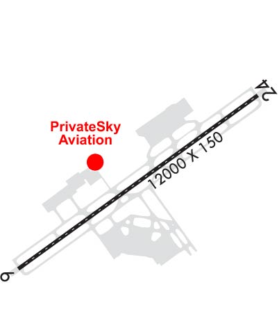
| Lat: N 2632.2 Long: W 08145.3 Elev: 30 Var: +04 Longest Runway: 12000 | ||
| Clr Del: 132.07 Dept. ATIS: 124.65 Arr. ATIS: 124.65 AWOS: 124.65 Ground: 121.9 Tower: 128.75 | ||
| |||||||||||||||||||||||||||||||||||||||||||||||||||||||||||||||||||||
| |||||||||||||||||||||||||||||||||||||||||||||||||||||||||||||||||||||
| |||||||||||||||||||||||||||||||||||||||||||||||||||||||||||||||||||||
| Rwy | Rwy | |||||||
| 12000x150 | 12000' | 111.50 - 058° | 12000x150 | 12000' | ||||
| Runway ID | Single Wheel | Double Wheel | Double Tandem Wheel | Dual Double Wheel |
| 06/24 | 120,000 | 250,000 | 550,000 | 1,120,000 |
| These numbers are Advisory and are not limits. The Airport Manager should have more accurate Weight Limits | ||||
 Airport Diagram might not be current. | |
| Facility Name: | SOUTHWEST FLORIDA INTL |
| City Name: | FORT MYERS |
| County: | LEE |
| State abbrev: | FL |
| State Name: | FLORIDA |
| Ownership: | PUBLICLY OWNED |
| Use: | OPEN TO THE PUBLIC |
| Owner's Name: | BOARD OF COM LEE CO PORT AUTH |
| Address: | PO BOX 398 |
| FORT MYERS, FL 33902 | |
| Owner's Phone: | 239-590-4800 |
| Manager's Name: | STEVEN HENNIGAN |
| Address: | 11000 TERMINAL ACCESS RD. |
| FORT MYERS, FL 33913 | |
| Phone: | 239-590-4400 |
| FAA Region: | SOUTHERN |
| FAA Field Office: | ORL |
| Date | Sunrise | Sunset |
|---|---|---|
| 03/13/25 Thursday | 7:39 | 19:35 |
| 03/14/25 Friday | 7:38 | 19:35 |
| 03/15/25 Saturday | 7:37 | 19:36 |
| 03/16/25 Sunday | 7:36 | 19:36 |
| 03/17/25 Monday | 7:35 | 19:37 |
| 03/18/25 Tuesday | 7:33 | 19:37 |
| 03/19/25 Wednesday | 7:32 | 19:38 |
| 03/20/25 Thursday | 7:31 | 19:38 |
| 03/21/25 Friday | 7:30 | 19:39 |
| 03/22/25 Saturday | 7:29 | 19:39 |
| 03/23/25 Sunday | 7:28 | 19:40 |
| 03/24/25 Monday | 7:27 | 19:40 |
| 03/25/25 Tuesday | 7:26 | 19:41 |
| 03/26/25 Wednesday | 7:25 | 19:41 |
| Airport Attendance Schedule | 7 Days A Week 0700-0100 |
| Airport Status | OPERATIONAL (This Status can change at any time - please check NOTAMS) |
| Airport Lighting Schedule | ACTVT MALSR RWY 06 - CTAF. ALL OTHER LGTS OPR CONSLY. |
| Airport Storage Available | Tie Downs, Hanger |
| Extra Services Available | Cargo Handling |
| Wind Indicator | YES - (lighted) |
| Control Tower | YES |
| CTAF Frequency | 128.750 |
| Unicom Frequency | 122.950 |
| Rotating Beacon Color | WG |
| Segmented Circle | YES |
| Landing Fee | YES; FEES FOR CHARTER, TRAVEL CLUBS & REVENUE PRODUCING ACFT. |
| Airport Inspected | FEDERAL - performed by FAA AIRPORTS FIELD PERSONNEL |
| Inspection Date | 05/02/2024 |
| Type of Fuel Available | Grade 100LL, JET A (freeze point -40C), JET A |
| Airframe Repair Service | MAJOR |
| Power Plant Repair Service | MAJOR |
| Latitude | N2632.2 |
| Longitude | W08145.3 (ESTIMATED) |
| Arpt Elevation | 29ft (SURVEYED) |
| Magnetic Variation | 04W |
| 10 miles SE | of FORT MYERS |
| Traffic Pattern Altitude | |
| Sectional Chart | MIAMI |
| Operations (Reported) | Yearly | Avg. Daily |
|---|---|---|
| General Aviation Transient | 0 | 0 |
| General Aviation Local | 0 | 0 |
| Air Taxi | 0 | 0 |
| Commerical | 0 | 0 |
| Commuter | 0 | 0 |
| Military | 0 | 0 |
| Aircraft based on Field | |
|---|---|
| General Aviation Singles | 0 |
| General Aviation Multi | 0 |
| Jet Aircraft | 0 |
| General Aviation Helicopters | 0 |
| Military Aircraft | 0 |
| Gliders | 0 |
| Ultralights | 0 |
| FSS on field | NO |
| FSS tie-in | MIAMI |
| FSS Phone | 1-800-WX-BRIEF |
| Who issues Notams | RSW |
| Notam D service at airport | YES |
| ARTCC Name | MIAMI |
| Airport Certification | AIRPORT RECEIVING SCHEDULED AIR CARRIER SERVICE FROM CARRIERS CERTIFICATED BY THE CIVIL AERONAUTICS BOARD |
| Aircraft Rescue & Firefighting Index | AIRPORT HAS A CERTIFICATE UNDER CFR PART 139 |
| Airport of Entry | No |
| Custom Landing Rights | YES; US CUSTOMS USER FEE ARPT. |
| Joint Civil/Military | No |
| Military Landing rights | YES |
| NATIONAL PLAN OF INTEGRATED AIRPORT SYSTEMS (NPIAS) |
| GRANT AGREEMENTS UNDER FAAP/ADAP/AIP |
| ASSURANCES PURSUANT TO TITLE VI, CIVIL RIGHTS ACT OF 1964 |
| CAUTION: OPEN BAGGAGE BAYS & CONST WITHIN TERMINAL RAMP AREA. AIRCREWS USE MINIMUM THRUST SETTINGS IN THESE AREAS, SPCLY DURG SINGLE ENG TAXI. CROSS-BLEED STARTS ONLY ALLOWED AFT REACHING THE TUG RELEASE POINT. |
| ACR USE RAMP PROC PRESCRIBED BY ARPT OPS. |
| TFC PROCD DRCTLY TO GATE UNLESS DRCTD BY ATC; ADVISE ATC IF GATE IS NOT AVBL. |
| DEP - ACFT MUST OBTAIN APVL FM GND CTL PRIOR TO PUSHBACK FM GATES B7, B9, C8, C9, D9 AND D11. PILOTS ADVISE TUG OPRS THAT YOU HAVE OBTAINED CLNC FM GND CTL PRIOR TO ENTERING TWY G. |
| GATES B7 & B9 EXP CALL SPOT 7. GATES C8 & C9 EXP CALL SPOT 4. |
| FOR CD IFUN TO CTC ON MIAMI CTR FREQ, CTC MIAMI ARTCC AT 305-716-1731 (0100-0700). |
| TWY A5 BTN FBO RAMP AND TWY A CLSD TO ACFT WINGSPAN MORE THAN 118 FT. |
| CAUTION: GS ANT 130 FT SW OF TWY A CNTRLN BTN TWY A1 & TWY A2. |
| OPERATE TRANSPONDERS WITH ALTITUDE REPORTING MODE AND ADS-B (IF EQUIPPED) ENABLED ON ALL AIRPORT SURFACES. |
| ALL ACFT ON RAMP EXP CLKWS FLOW. OBND TFC FM GATES D6, D8 & D10 PCD TO CALL SPOT 1; GATES D9 AND D11 EXP CALL SPOT 2. OBND TFC FM GATES C2, C4, C6, D1, D3, D5 & D7 PCD TO CALL SPOT 3; OBND TFC FM GATES B2, B4, B6, B8, C1, C3, C5 & C7 PCD TO CALL SPOT 5; OBND TFC FM GATES B1, B3 & B5 PCD TO CALL SPOT 9; ALL OBND TFC REQ TAXI INSTRUCTIONS. |
| NO HELI OPS PERMITTED ON TRML APRON. |
| LGTS ON PARALLEL ROAD & PARKING LOT NW OF RWY 06/24 CAN BE MISTAKEN FOR RWY & APCH ENVIRONMENT. |
| GND CLNC RQRD PRIOR TO ENTERING TWY G. |
| RWY USE PROGRAM IN EFFECT; USE DISTANT NOISE ABATEMENT DEP PROFILE. VISUAL APCH TO RWY 06 W OF FORT MYERS BEACH MAINTAIN 3000 FT UNTIL CROSSING SHORELINE 12 NM SW OF ARPT. RWY 24 PREFERRED BTN 2200-0600. FOR NOISE ABATEMENT PROC CTC AMGR. |
| RWY 06/2 4 PCR VALUE: 740/F/A/X/T |
Airport Communications & Frequencies:
| |||||||||||||||||||||||||||||||||||||||||||||||||||||||||||||||||
| Runway: 06 | Runway: 24 | ||
| Mag heading: | 58° | Mag heading: | 238° |
| Rwy Slope: | .03% Up | Rwy Slope: | -.03% Down |
| Approach: | ILS/DME | Approach: | |
| Pattern: | Right Traffic | Pattern: | Left Traffic |
| Markings: | PRECISION INSTRUMENT | Markings: | PRECISION INSTRUMENT |
| Marking Condition: | GOOD | Marking Condition: | GOOD |
| Arresting Dev: | Arresting Dev: | ||
| Lat & Long: | N2631.6 W08146.2 | Lat. & Long.: | N2632.8 W08144.4 |
| Elev: | 26.6 ft. MSL | Elev: | 29.8 ft. MSL |
| TCH: | 69 ft. AGL | TCH: | 72 ft. AGL |
| Visual Glide Path: | 3.00 degrees | Visual Glide Path: | 3.00 degrees |
| Displaced Threshold: | No | Displaced Threshold: | No |
| Touchdown Zone: | YES | Touchdown Zone: | YES |
| Touchdown Elev.: | 27.0 feet | Touchdown Elev.: | 29.9 feet |
| Visual Glide Slope: | 4-Light PAPI on LEFT side of Runway | Visual Glide Slope: | 4-Light PAPI on LEFT side of Runway |
| RVR Equipment: | TOUCHDOWN | RVR Equipment: | ROLLOUT |
| RVV Equipment: | YES | RVV Equipment: | NO |
| Approach Lights: | MALSR - 1,400 foot medium intensity approach lighting system with runway alignment indicator lights | Approach Lights: | |
| REIL: | NO | REIL: | YES |
| Centerline Lights: | YES | Centerline Lights: | YES |
| Touchdown lights: | YES | Touchdown lights: | NO |
| Runway Category: | Precision Instrument Runway | Runway Category: | D |
| Declared Distances: | Declared Distances: |
Thanks for using FltPlan.com
all rights reserved © 1999-2025 by Flight Plan LLC