
| SAN DIEGO INTL SAN DIEGO CA |
| |
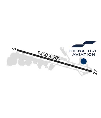
| Lat: N 3244.0 Long: W 11711.4 Elev: 17 Var: -11 Longest Runway: 9401 | ||
| Clr Del: 125.9 Dept. ATIS: 134.8 Arr. ATIS: 134.8 Ground: 123.9 Tower: 118.3 | ||
| |||||||||||||||||||||||||||||||||||||||||||||||||||||||||||||||||||||
| |||||||||||||||||||||||||||||||||||||||||||||||||||||||||||||||||||||
| |||||||||||||||||||||||||||||||||||||||||||||||||||||||||||||||||||||
| |||||||||||||||||||||||||||||||||||||||||||||||||||||||||||||||||||||
| FBOs at nearby airports who want your business: | |||||||||||
| |||||||||||
| Rwy | Rwy | |||||||
| 9401x200 | 8401' | 111.55 - 094° | 9401x200 | 7591' | 110.90 - 275° | |||
| Runway ID | Single Wheel | Double Wheel | Double Tandem Wheel | Dual Double Wheel |
| 09/27 | 120,000 | 250,000 | 550,000 | 1,120,000 |
| These numbers are Advisory and are not limits. The Airport Manager should have more accurate Weight Limits | ||||
 Airport Diagram might not be current. | |
| Facility Name: | SAN DIEGO INTL |
| City Name: | SAN DIEGO |
| County: | SAN DIEGO |
| State abbrev: | CA |
| State Name: | CALIFORNIA |
| Ownership: | PUBLICLY OWNED |
| Use: | OPEN TO THE PUBLIC |
| Owner's Name: | SAN DIEGO CNTY REG ARPT AUTHORITY |
| Address: | 2417 MCCAIN ROAD |
| SAN DIEGO, CA 92101-1022 | |
| Owner's Phone: | 619-400-2710 |
| Manager's Name: | KIMBERLY BECKER |
| Address: | PO BOX 82776 |
| SAN DIEGO, CA 92138-2776 | |
| Phone: | 619-400-2710 |
| FAA Region: | WESTERN-PACIFIC |
| FAA Field Office: | LAX |
| Date | Sunrise | Sunset |
|---|---|---|
| 03/15/25 Saturday | 6:59 | 18:57 |
| 03/16/25 Sunday | 6:58 | 18:57 |
| 03/17/25 Monday | 6:57 | 18:58 |
| 03/18/25 Tuesday | 6:55 | 18:59 |
| 03/19/25 Wednesday | 6:54 | 19:00 |
| 03/20/25 Thursday | 6:53 | 19:00 |
| 03/21/25 Friday | 6:51 | 19:01 |
| 03/22/25 Saturday | 6:50 | 19:02 |
| 03/23/25 Sunday | 6:49 | 19:02 |
| 03/24/25 Monday | 6:48 | 19:03 |
| 03/25/25 Tuesday | 6:46 | 19:04 |
| 03/26/25 Wednesday | 6:45 | 19:05 |
| 03/27/25 Thursday | 6:44 | 19:05 |
| 03/28/25 Friday | 6:42 | 19:06 |
| Airport Attendance Schedule | CONTINUOUS |
| Airport Status | OPERATIONAL (This Status can change at any time - please check NOTAMS) |
| Airport Lighting Schedule | |
| Airport Storage Available | Tie Downs, Hanger |
| Extra Services Available | Air Freight, Air Ambulance, Avionics, Cargo Handling, Charter, Aircraft Rental, Annual Surveying |
| Wind Indicator | YES - (lighted) |
| Control Tower | YES |
| CTAF Frequency | |
| Unicom Frequency | |
| Rotating Beacon Color | WG |
| Segmented Circle | NO |
| Landing Fee | NO |
| Airport Inspected | FEDERAL - performed by FAA AIRPORTS FIELD PERSONNEL |
| Inspection Date | 06/30/2023 |
| Type of Fuel Available | Grade 100LL, JET A (freeze point -40C) |
| Airframe Repair Service | MINOR |
| Power Plant Repair Service | MINOR |
| Latitude | N3244.0 |
| Longitude | W11711.4 (ESTIMATED) |
| Arpt Elevation | 16ft (ESTIMATED) |
| Magnetic Variation | 11E |
| 2 miles W | of SAN DIEGO |
| Traffic Pattern Altitude | |
| Sectional Chart | LOS ANGELES |
| Operations (Reported) | Yearly | Avg. Daily |
|---|---|---|
| General Aviation Transient | 0 | 0 |
| General Aviation Local | 0 | 0 |
| Air Taxi | 0 | 0 |
| Commerical | 0 | 0 |
| Commuter | 0 | 0 |
| Military | 0 | 0 |
| Aircraft based on Field | |
|---|---|
| General Aviation Singles | 0 |
| General Aviation Multi | 0 |
| Jet Aircraft | 0 |
| General Aviation Helicopters | 0 |
| Military Aircraft | 0 |
| Gliders | 0 |
| Ultralights | 0 |
| FSS on field | NO |
| FSS tie-in | SAN DIEGO |
| FSS Phone | 1-800-WX-BRIEF |
| Who issues Notams | SAN |
| Notam D service at airport | YES |
| ARTCC Name | LOS ANGELES |
| Airport Certification | AIRPORT RECEIVING SCHEDULED AIR CARRIER SERVICE FROM CARRIERS CERTIFICATED BY THE CIVIL AERONAUTICS BOARD |
| Aircraft Rescue & Firefighting Index | AIRPORT HAS A CERTIFICATE UNDER CFR PART 139 |
| Airport of Entry | YES |
| Custom Landing Rights | No |
| Joint Civil/Military | No |
| Military Landing rights | YES |
| NATIONAL PLAN OF INTEGRATED AIRPORT SYSTEMS (NPIAS) |
| GRANT AGREEMENTS UNDER FAAP/ADAP/AIP |
| CONVEYANCE UNDER SCETION 16, FEDERAL AIRPORT ACT OF 1946 OR SECTION 23, AIRPORT AND AIRWAY DEVELOPMENT ACT OF 1970 |
| ASSURANCES PURSUANT TO TITLE VI, CIVIL RIGHTS ACT OF 1964 |
| TO REDUCE JET BLAST IMPACT AT N END OF TWY F ACFT WILL NOT START ENG UNTIL 800 FT FM N END OF TWY F; ABEAM THE SECOND PARKING PAD. |
| ULTRALIGHT ACFT PROHIBITED ON AP. |
| 747 AND LARGER ACFT ARE PROHIBITED FM MAKING INTERSECTION TKOFS. |
| INTERMITTENT PRESENCE OF BIRDS ON AND INVOF OF ARPT. |
| TERRAIN & BLDGS TO 500' MSL N & E WITHIN 1 1/2 MI. |
| CROSS-BLEED ENGINE STARTS PERMITTED ONLY ON PARALLEL TWY WITH ACFT ALIGNED ON TWY CNTRLN. |
| OUTBOARD ENGINES OF FOUR-ENGINE ACFT ARE TO BE KEPT AT IDLE POWER FOR ALL GND MANEUVERING. |
| PILOTS REQUIRED TO CTC ATCT GROUND CONTROLLER PRIOR TO PUSHBACK, TOW OUT AND TAXI FOR TRAFFIC ADVISORIES. |
| MILITARY ACFT ON OFFICIAL BUSINESS ONLY CONTACT ARPT OPS AT 619-400-2710 FOR PPR. |
| PRACTICE APPROACHES AND TGL PROHIBITED. |
| TWY C EDGE LGTS OTS INDEFLY. |
| ACFT CROSSING RY 09/27 ON TWY C6, HOLD SHORT OF TWY C6 FACING WEST ON TWY C, PARALLEL TO RY. |
| DUE TO PAEW ON RY 09-27, 30 MINUTE PPR 0830-1230Z FOR ALL LANDINGS AND DEPARTURES CALL 619-400-2710. |
| 30 MIN PPR (619-400-2710) FOR ACFT WITH OVER 171 FT WINGSPAN. |
| IN THE EVENT OF A DIVERSION OR IRREGULAR OPERATIONS EVENTS, ACFT OPERATORS CONTACT THE APT DUTY MGR (619) 400-2710 FOR PPR DUE TO LIMITATIONS ASSOCIATED WITH HANDLING DIVERTED FLTS. LIMITATIONS INCLUDE RESTRICTED GATE SPACE, CUSTOMS SERVICES AS WELL AS ACFT SERVICING & PARKING. |
| TAXIING ACFT ARE PROHIBITED FROM PASSING TO THE SOUTH OF ACFT LCTD ON TWY B INTO ALLEY LCTD BTWN GATES 7 AND 14. |
| TAXIING ACFT SHALL FOLLOW LEAD-IN LINES UNTIL THE NOSE WHEEL OF THE ACFT HAS ENTERED THE NON-MOVEMENT AREA OF THE ALLEY. |
| FOR ACCESS TO/FR TERMINAL 2: GATES 23, 25, 27, 29, 31, 33-51 AND THE ISLAND AND WEST RON PRKG RAMPS, CTC RAMP CTL ON 129.775 SRY 131.975 FR 0600-2400. FR 0000-0600 CTC GROUND CTL ON 123.9. |
| TAXILANE A RSTRD TO ACFT WITH WINGSPANS OF 135 FT OR LESS. |
| RWY STATUS LGTS IN OPN. |
| ACFT WITH WINGSPANS GTR THAN 171 FT (52M) RSTD FROM USING TWY D SOUTH OF TWY B, AND WHEN EXITING RWY 09 WB ON TWY B. |
| DEP CURFEW IN EFCT. DEPS PROHIBITED 2330-0630. SGFNT FINES. MED FLTS EXEMPT WITH FORM. NOISE OFC 619-400-2660. |
| RWY 09/2 7 PCR VALUE: 851/F/A/X/T |
Airport Communications & Frequencies:
| |||||||||||||||||||||||||||||||||||||||
| Runway: 09 | Runway: 27 | ||
| Mag heading: | 95° | Mag heading: | 275° |
| Rwy Slope: | .03% Up | Rwy Slope: | -.03% Down |
| Approach: | ILS/DME | Approach: | LOC/DME |
| Pattern: | Left Traffic | Pattern: | Right Traffic |
| Markings: | PRECISION INSTRUMENT | Markings: | PRECISION INSTRUMENT |
| Marking Condition: | GOOD | Marking Condition: | GOOD |
| Arresting Dev: | Arresting Dev: | EMAS; ENGINEERED MATERIALS ARRESTING SYSTEM (EMAS) 315 FT IN LENGTH BY 218 FT IN WIDTH LCTD AT DER 27. | |
| Lat & Long: | N3244.2 W11712.3 | Lat. & Long.: | N3243.8 W11710.5 |
| Elev: | 13.9 ft. MSL | Elev: | 16.4 ft. MSL |
| TCH: | 76 ft. AGL | TCH: | 66 ft. AGL |
| Visual Glide Path: | 3.30 degrees | Visual Glide Path: | 3.50 degrees |
| Displaced Threshold: | 1000 feet | Displaced Threshold: | 1810 feet |
| Touchdown Zone: | YES | Touchdown Zone: | YES |
| Touchdown Elev.: | 16.7 feet | Touchdown Elev.: | 16.8 feet |
| Visual Glide Slope: | 4-Light PAPI on LEFT side of Runway | Visual Glide Slope: | 4-Light PAPI on RIGHT side of Runway; PAPI UNUSBL BYD 5 DEG L & R OF CNTLN. |
| RVR Equipment: | TOUCHDOWN-ROLLOUT | RVR Equipment: | TOUCHDOWN-ROLLOUT |
| RVV Equipment: | NO | RVV Equipment: | NO |
| Approach Lights: | MALSR - 1,400 foot medium intensity approach lighting system with runway alignment indicator lights | Approach Lights: | MALS - 1,400 foot medium intensity approach lighting system; MALS RWY 27 THR TO 1400'. |
| REIL: | NO | REIL: | NO |
| Centerline Lights: | YES | Centerline Lights: | YES |
| Touchdown lights: | YES | Touchdown lights: | YES |
| Runway Category: | Precision Instrument Runway | Runway Category: | Runway with a Non-precision Approach having visibility minimums greater than 3/4 mile |
| Declared Distances: | TORA:8280' TODA:9401' ASDA:8280' LDA:7280' | Declared Distances: | TORA:9401' TODA:9401' ASDA:9401' LDA:7591' |
| Obstructions: | TREE | Obstructions: | SIGN |
| Marked: | NOT Marked/Lighted | Marked: | NOT Marked/Lighted |
| Clearance slope: | 15:1; APCH RATIO 44:1 TO DSPLCD THR. | Clearance slope: | RY 27 TREE 364' ABV RY END 6800' FM RY END & 1050' R OF RY CNTRLN; APCH 19:1 TO DSPLCD THR. |
| Obstruction height: | 31 feet AGL | Obstruction height: | 61 feet AGL |
| Dist. from runway: | 674 feet | Dist. from runway: | 250 feet |
| Centerline offset: | 385 left of centerline | Centerline offset: | 500 feet right of centerline |
| Comments: | Comments: | +40' LGT POLE 110' FROM RWY END 260' RIGHT. |
Thanks for using FltPlan.com
all rights reserved © 1999-2025 by Flight Plan LLC


