| SHEBOYGAN COUNTY MEMORIAL SHEBOYGAN WI |
| |
| Lat: N 4346.2 Long: W 08751.1 Elev: 755 Var: +02 Longest Runway: 6800 | ||
| Clr Del: 127.37 AWOS: 110.0 CTAF: 122.7 | ||
| ||||||||||||||||||||||||||||||||||||||||||||||||||||||||||||||||||||
| ||||||||||||||||||||||||||||||||||||||||||||||||||||||||||||||||||||
| ||||||||||||||||||||||||||||||||||||||||||||||||||||||||||||||||||||
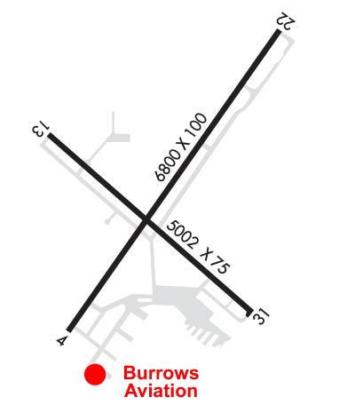
| Rwy | Rwy | |||||||
| 6800x100 | 6800' | 6800x100 | 6800' | 110.70 - 217° | ||||
| 5002x75 | 5002' | 5002x75 | 5002' | |||||
| Runway ID | Single Wheel | Double Wheel | Double Tandem Wheel | Dual Double Wheel |
| 04/22 | 45,000 | 98,000 | N/A | N/A |
| 13/31 | 30,000 | 72,000 | N/A | N/A |
| These numbers are Advisory and are not limits. The Airport Manager should have more accurate Weight Limits | ||||
 Airport Diagram might not be current. | |
| Facility Name: | SHEBOYGAN COUNTY MEML |
| City Name: | SHEBOYGAN |
| County: | SHEBOYGAN |
| State abbrev: | WI |
| State Name: | WISCONSIN |
| Ownership: | PUBLICLY OWNED |
| Use: | OPEN TO THE PUBLIC |
| Owner's Name: | SHEBOYGAN COUNTY |
| Address: | N6180 RESOURCE DRIVE |
| SHEBOYGAN FALLS, WI 53085 | |
| Owner's Phone: | 920-467-2978 |
| Manager's Name: | MATTHEW GRENOBLE |
| Address: | N6180 RESOURCE DR. |
| SHEBOYGAN FALLS, WI 53085 | |
| Phone: | 920-467-2978 |
| FAA Region: | GREAT LAKES |
| FAA Field Office: | CHI |

| Date | Sunrise | Sunset |
|---|---|---|
| 09/24/21 Friday | 6:41 | 18:46 |
| 09/25/21 Saturday | 6:42 | 18:44 |
| 09/26/21 Sunday | 6:43 | 18:42 |
| 09/27/21 Monday | 6:44 | 18:40 |
| 09/28/21 Tuesday | 6:45 | 18:38 |
| 09/29/21 Wednesday | 6:46 | 18:36 |
| 09/30/21 Thursday | 6:48 | 18:35 |
| 10/01/21 Friday | 6:49 | 18:33 |
| 10/02/21 Saturday | 6:50 | 18:31 |
| 10/03/21 Sunday | 6:51 | 18:29 |
| 10/04/21 Monday | 6:52 | 18:27 |
| 10/05/21 Tuesday | 6:53 | 18:26 |
| 10/06/21 Wednesday | 6:55 | 18:24 |
| 10/07/21 Thursday | 6:56 | 18:22 |
| Airport Attendance Schedule | MON-FRI 0600-DUSK, SAT-SUN DAWN-DUSK |
| Airport Status | OPERATIONAL (This Status can change at any time - please check NOTAMS) |
| Airport Lighting Schedule | HIRL RY 04/22 & MIRL RY 13/31 PRESET LOW INTST; TO INCR INTST & ACTVT PAPI RY 04/22; REIL RY 04 & MALSR RY 22 - CTAF. |
| Airport Storage Available | Tie Downs, Hanger |
| Extra Services Available | NONE |
| Wind Indicator | YES - (unlit) |
| Control Tower | NO |
| CTAF Frequency | 122.700 |
| Unicom Frequency | 122.700 |
| Rotating Beacon Color | CLEAR-GREEN (Light Land Airport) |
| Segmented Circle | YES |
| Landing Fee | NO |
| Airport Inspected | STATE - performed by STATE AERONAUTICAL PERSONNEL |
| Inspection Date | 06/10/2020 |
| Type of Fuel Available | Grade 100LL, JET A (freeze point -40C); -1024 HR FUEL AVBL WITH CREDIT CARD. |
| Airframe Repair Service | MAJOR |
| Power Plant Repair Service | MAJOR |
| Latitude | N4346.2 |
| Longitude | W08751.1 (ESTIMATED) |
| Arpt Elevation | 755ft (SURVEYED) |
| Magnetic Variation | 02W |
| 3 miles NW | of SHEBOYGAN |
| Traffic Pattern Altitude | 800 |
| Sectional Chart | CHICAGO |
| Operations (Reported) | Yearly | Avg. Daily |
|---|---|---|
| General Aviation Transient | 18000 | 49 |
| General Aviation Local | 20000 | 55 |
| Air Taxi | 5000 | 14 |
| Commerical | 0 | 0 |
| Commuter | 0 | 0 |
| Military | 200 | 1 |
| Aircraft based on Field | |
|---|---|
| General Aviation Singles | 37 |
| General Aviation Multi | 6 |
| Jet Aircraft | 6 |
| General Aviation Helicopters | 0 |
| Military Aircraft | 0 |
| Gliders | 0 |
| Ultralights | 0 |
| FSS on field | NO |
| FSS tie-in | GREEN BAY |
| FSS Phone | 1-800-WX-BRIEF |
| Who issues Notams | SBM |
| Notam D service at airport | YES |
| ARTCC Name | CHICAGO |
| Airport Certification | |
| Aircraft Rescue & Firefighting Index | None |
| Airport of Entry | No |
| Custom Landing Rights | No; US CUSTOMS USER FEE ARPT. |
| Joint Civil/Military | No |
| Military Landing rights | YES |
| NATIONAL PLAN OF INTEGRATED AIRPORT SYSTEMS (NPIAS) |
| GRANT AGREEMENTS UNDER FAAP/ADAP/AIP |
| ASSURANCES PURSUANT TO TITLE VI, CIVIL RIGHTS ACT OF 1964 |
| ULTRALIGHT ACTVTY ON & IN VCNTY OF ARPT. |
| WATERFOWL & DEER ON & INVOF ARPT. |
| GCO AVBL ON FREQ 121.725 THRU FLT SVCS. |
Airport Communications & Frequencies:
| |||||||||||||||||||
| Runway: 04 | Runway: 22 | ||
| Mag heading: | 37° | Mag heading: | 217° |
| Rwy Slope: | -.02% Down | Rwy Slope: | .02% Up |
| Approach: | Approach: | ILS/DME | |
| Pattern: | Left Traffic | Pattern: | Left Traffic |
| Markings: | PRECISION INSTRUMENT | Markings: | PRECISION INSTRUMENT |
| Marking Condition: | FAIR | Marking Condition: | FAIR |
| Arresting Dev: | Arresting Dev: | ||
| Lat & Long: | N4345.8 W08751.5 | Lat. & Long.: | N4346.7 W08750.6 |
| Elev: | 743.9 ft. MSL | Elev: | 742.7 ft. MSL |
| TCH: | 52 ft. AGL | TCH: | 49 ft. AGL |
| Visual Glide Path: | 3.00 degrees | Visual Glide Path: | 3.00 degrees |
| Displaced Threshold: | No | Displaced Threshold: | No |
| Touchdown Zone: | YES | Touchdown Zone: | YES |
| Touchdown Elev.: | 744.1 feet | Touchdown Elev.: | 742.7 feet |
| Visual Glide Slope: | 4-Light PAPI on LEFT side of Runway | Visual Glide Slope: | 4-Light PAPI on LEFT side of Runway |
| RVR Equipment: | RVR Equipment: | ||
| RVV Equipment: | NO | RVV Equipment: | NO |
| Approach Lights: | Approach Lights: | MALSR - 1,400 foot medium intensity approach lighting system with runway alignment indicator lights | |
| REIL: | YES | REIL: | NO |
| Centerline Lights: | NO | Centerline Lights: | NO |
| Touchdown lights: | NO | Touchdown lights: | NO |
| Runway Category: | Runway with a Non-precision Approach having visibility minimums greater than 3/4 mile | Runway Category: | Precision Instrument Runway |
| Declared Distances: | Declared Distances: |
| Runway: 13 | Runway: 31 | ||
| Mag heading: | 132° | Mag heading: | 312° |
| Rwy Slope: | -.31% Down | Rwy Slope: | .31% Up |
| Approach: | Approach: | ||
| Pattern: | Left Traffic | Pattern: | Left Traffic |
| Markings: | NONPRECISION INSTRUMENT | Markings: | NONPRECISION INSTRUMENT |
| Marking Condition: | GOOD | Marking Condition: | GOOD |
| Arresting Dev: | Arresting Dev: | ||
| Lat & Long: | N4346.4 W08751.6 | Lat. & Long.: | N4345.8 W08750.7 |
| Elev: | 755.2 ft. MSL | Elev: | 739.7 ft. MSL |
| TCH: | 34 ft. AGL | TCH: | 40 ft. AGL |
| Visual Glide Path: | 3.00 degrees | Visual Glide Path: | 3.00 degrees |
| Displaced Threshold: | No | Displaced Threshold: | No |
| Touchdown Zone: | YES | Touchdown Zone: | YES |
| Touchdown Elev.: | 755.2 feet | Touchdown Elev.: | 745.6 feet |
| Visual Glide Slope: | 4-Light PAPI on LEFT side of Runway; OPRS CONSLY. | Visual Glide Slope: | 4-Light PAPI on LEFT side of Runway; OPRS CONSLY. UNUSBL BYD 4 DEGS RIGHT OF CNTRLN. |
| RVR Equipment: | RVR Equipment: | ||
| RVV Equipment: | NO | RVV Equipment: | NO |
| Approach Lights: | Approach Lights: | ||
| REIL: | NO | REIL: | NO |
| Centerline Lights: | NO | Centerline Lights: | NO |
| Touchdown lights: | NO | Touchdown lights: | NO |
| Runway Category: | Runway with a Non-precision Approach having visibility minimums greater than 3/4 mile | Runway Category: | Runway with a Non-precision Approach having visibility minimums greater than 3/4 mile |
| Declared Distances: | Declared Distances: | ||
| Obstructions: | TREES | Obstructions: | TREES |
| Marked: | NOT Marked/Lighted | Marked: | NOT Marked/Lighted |
| Clearance slope: | 28:1 | Clearance slope: | 28:1 |
| Obstruction height: | 75 feet AGL | Obstruction height: | 57 feet AGL |
| Dist. from runway: | 2300 feet | Dist. from runway: | 1800 feet |
| Centerline offset: | Centerline offset: | 440 feet right of centerline | |
| Comments: | Comments: |
Thanks for using FltPlan.com
all rights reserved © 1999-2021 by Flight Plan LLC