
| STOCKTON METROPOLITAN STOCKTON CA |
| |
| Lat: N 3753.7 Long: W 12114.3 Elev: 33 Var: -14 Longest Runway: 10249 | ||
| Dept. ATIS: 118.25 Arr. ATIS: 118.25 AWOS: 118.25 Ground: 121.9 Tower: 120.3 | ||
| ||||||||||||||||||||||||||||||||||||||||||||||||||||||||||||||||||||
| ||||||||||||||||||||||||||||||||||||||||||||||||||||||||||||||||||||
| ||||||||||||||||||||||||||||||||||||||||||||||||||||||||||||||||||||
| ||||||||||||||||||||||||||||||||||||||||||||||||||||||||||||||||||||
| Rwy | Rwy | |||||||
| 10249x150 | 9249' | 10249x150 | 9650' | 109.10 - 293° | ||||
| 4448x75 | 4448' | 4448x75 | 4448' | |||||
| Runway ID | Single Wheel | Double Wheel | Double Tandem Wheel | Dual Double Wheel |
| 11L/29R | 40,000 | 150,000 | 360,000 | 650,000 |
| 11R/29L | 12,500 | N/A | N/A | N/A |
| H1 | 45,000 | 55,000 | N/A | N/A |
| These numbers are Advisory and are not limits. The Airport Manager should have more accurate Weight Limits | ||||
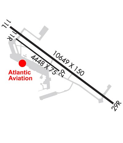 Airport Diagram might not be current. | |
| Facility Name: | STOCKTON METRO |
| City Name: | STOCKTON |
| County: | SAN JOAQUIN |
| State abbrev: | CA |
| State Name: | CALIFORNIA |
| Ownership: | PUBLICLY OWNED |
| Use: | OPEN TO THE PUBLIC |
| Owner's Name: | COUNTY OF SAN JOAQUIN |
| Address: | 5000 S AIRPORT WAY |
| STOCKTON, CA 95206 | |
| Owner's Phone: | 209-468-4700 |
| Manager's Name: | RUSSELL STARK |
| Address: | 5000 S. AIRPORT WAY ROOM 202 |
| STOCKTON, CA 95206 | |
| Phone: | 209-468-4700 |
| FAA Region: | WESTERN-PACIFIC |
| FAA Field Office: | SFO |
| Date | Sunrise | Sunset |
|---|---|---|
| 09/24/21 Friday | 6:54 | 18:59 |
| 09/25/21 Saturday | 6:55 | 18:57 |
| 09/26/21 Sunday | 6:56 | 18:56 |
| 09/27/21 Monday | 6:57 | 18:54 |
| 09/28/21 Tuesday | 6:58 | 18:53 |
| 09/29/21 Wednesday | 6:59 | 18:51 |
| 09/30/21 Thursday | 7:00 | 18:50 |
| 10/01/21 Friday | 7:00 | 18:48 |
| 10/02/21 Saturday | 7:01 | 18:47 |
| 10/03/21 Sunday | 7:02 | 18:45 |
| 10/04/21 Monday | 7:03 | 18:44 |
| 10/05/21 Tuesday | 7:04 | 18:42 |
| 10/06/21 Wednesday | 7:05 | 18:41 |
| 10/07/21 Thursday | 7:06 | 18:39 |
| Airport Attendance Schedule | CONTINUOUS |
| Airport Status | OPERATIONAL (This Status can change at any time - please check NOTAMS) |
| Airport Lighting Schedule | ACTVT HIRL RY 11L/29R, PAPI RY 11L AND RY 29R, MALSR RY 29R - CTAF. |
| Airport Storage Available | Hanger |
| Extra Services Available | Charter, Flight Instruction, Aircraft Rental, Aircraft Sales |
| Wind Indicator | YES - (lighted) |
| Control Tower | YES |
| CTAF Frequency | 120.300 |
| Unicom Frequency | 122.950 |
| Rotating Beacon Color | CLEAR-GREEN (Light Land Airport) |
| Segmented Circle | YES |
| Landing Fee | YES; LNDG FEE FOR ACFT OVER 12500 LBS. |
| Airport Inspected | FEDERAL - performed by FAA AIRPORTS FIELD PERSONNEL |
| Inspection Date | 05/20/2021 |
| Type of Fuel Available | Grade 100, Grade 100LL, JET A (freeze point -40C); -10FUEL & SVC 0500-2100; OTHER TIMES CALL (209) 982-1622 - SVC CHARGE. |
| Airframe Repair Service | MAJOR |
| Power Plant Repair Service | MAJOR |
| Latitude | N3753.7 |
| Longitude | W12114.3 (ESTIMATED) |
| Arpt Elevation | 33ft (SURVEYED) |
| Magnetic Variation | 14E |
| 3 miles SE | of STOCKTON |
| Traffic Pattern Altitude | |
| Sectional Chart | SAN FRANCISCO |
| Operations (Reported) | Yearly | Avg. Daily |
|---|---|---|
| General Aviation Transient | 23297 | 64 |
| General Aviation Local | 24713 | 68 |
| Air Taxi | 1575 | 4 |
| Commerical | 2649 | 7 |
| Commuter | 0 | 0 |
| Military | 2911 | 8 |
| Aircraft based on Field | |
|---|---|
| General Aviation Singles | 120 |
| General Aviation Multi | 16 |
| Jet Aircraft | 20 |
| General Aviation Helicopters | 3 |
| Military Aircraft | 20 |
| Gliders | 0 |
| Ultralights | 1 |
| FSS on field | NO |
| FSS tie-in | RANCHO MURIETA |
| FSS Phone | 1-800-WX-BRIEF |
| Who issues Notams | SCK |
| Notam D service at airport | YES |
| ARTCC Name | OAKLAND |
| Airport Certification | AIRPORT RECEIVING SCHEDULED AIR CARRIER SERVICE FROM CARRIERS CERTIFICATED BY THE CIVIL AERONAUTICS BOARD; CLSD TO UNSKED ACR OPNS WITH MORE THAN 30 PSGR SEATS EXCP ONE HR PPR, CALL AMGR (209) 468-4700 OR 4722; AFTER HRS CALL (209) 468-4722. RWY 11R/29L NOT AVBL FOR SKED ACR OPNS WITH MORE THAN 9 PSGR SEATS OR UNSKED ACR AT LEAST 31 PSGR SEATS. |
| Aircraft Rescue & Firefighting Index | AIRPORT HAS A CERTIFICATE UNDER CFR PART 139 |
| Airport of Entry | No |
| Custom Landing Rights | No |
| Joint Civil/Military | No |
| Military Landing rights | YES |
| NATIONAL PLAN OF INTEGRATED AIRPORT SYSTEMS (NPIAS) |
| GRANT AGREEMENTS UNDER FAAP/ADAP/AIP |
| SURPLUS PROPERTY AGREEMENT UNDER PUBLIC LAW 289 |
| ASSURANCES PURSUANT TO TITLE VI, CIVIL RIGHTS ACT OF 1964 |
| SEAGULLS ON AND IN VCNTY OF ARPT MOSTLY DURING RAINY WEATHER. |
| TRML APN, CARGO APN, TWYS B, B2, B3, F, D, D7, D9, AND H FOR ACFT OVER 12500 LBS. ALL OTR TWYS RSTRD TO ACFT LESS THAN 12500 LBS. |
| PAVEMENT PRIOR TO THLD OF RWY 11L NOT AVBL FOR TAXI BACK OPS. |
| FOR CD WHEN ATCT CLSD CTC NORCAL APCH AT 916-361-0516. |
| TSNT PILOTS USE CTN; DO NOT ENTER THE TSA RSTRD AREA ADJ TO THE TSNT PRKG AREA. |
| TWY F RSTRD TO ACFT WINGSPAN LESS THAN 118 FT. |
| AVOID OVERFLYING SAN JOAQUIN GENERAL HOSPITAL & THE CITY OF MANTECA. |
| ARPT CLSD TO TGL & PLANNED LOW APCHS FOR TURBOJET ACFT 2200-0700 EXCEPT BY PPR FM AMGR PART 36 STAGE 3 ACFT. |
| PRACTICE CIRCLING APPROACHES TO RWYS 11L/11R NA FOR ANY TURBINE POWERED ACFT/PROP DRIVEN ACFT EXCEEDING 12500 LBS EXCP BY PPR FM AMGR. |
| MILITARY USE: ARNG OPR 1500-2330Z++ MON-FRI. DSN 466-5319, C209-983-5319, FAX 5391. PPR REQUIRED. LDTD TRAN SVC AND MAINT AVBL FOR CH47. |
| THE FLWG AREAS NOT VISIBLE FM ATCT: TWY B FM TRML APN TO INT AT TWY M; TWY B FM 300 FT W OF TWY J TO 375 FT E OF TWY J; NON MOVEMENT AREA S OF TWY B FROM TRML APN TO 200 FT W OF TWY H; SE HALF OF TRML APN; TSNT PRKG APN. |
| TRANSIENT PARKING AVBL AT FBO. |
| BE ALERT TO ELEVD MALSR APCH END RWY 29R LCTD ON BLAST PAD. |
Airport Communications & Frequencies:
| |||||||||||||||||||||||||||||||||||||
| Runway: 11L | Runway: 29R | ||
| Mag heading: | 114° | Mag heading: | 294° |
| Rwy Slope: | .07% Up | Rwy Slope: | -.07% Down |
| Approach: | Approach: | ILS/DME | |
| Pattern: | Left Traffic | Pattern: | Right Traffic |
| Markings: | PRECISION INSTRUMENT | Markings: | PRECISION INSTRUMENT |
| Marking Condition: | GOOD | Marking Condition: | GOOD |
| Arresting Dev: | Arresting Dev: | ||
| Lat & Long: | N3754.1 W12115.1 | Lat. & Long.: | N3753.1 W12113.4 |
| Elev: | 26.5 ft. MSL | Elev: | 33.2 ft. MSL |
| TCH: | 75 ft. AGL | TCH: | 71 ft. AGL |
| Visual Glide Path: | 3.00 degrees | Visual Glide Path: | 3.00 degrees |
| Displaced Threshold: | 1000 feet | Displaced Threshold: | 599 feet |
| Touchdown Zone: | YES | Touchdown Zone: | YES |
| Touchdown Elev.: | 29.1 feet | Touchdown Elev.: | 32.3 feet |
| Visual Glide Slope: | 4-Light PAPI on LEFT side of Runway | Visual Glide Slope: | 4-Light PAPI on LEFT side of Runway; UNUSBL BYD 9 DEGS RIGHT OF CNTRLN. |
| RVR Equipment: | TOUCHDOWN-MIDFIELD-ROLLOUT | RVR Equipment: | TOUCHDOWN-MIDFIELD-ROLLOUT |
| RVV Equipment: | NO | RVV Equipment: | YES |
| Approach Lights: | Approach Lights: | MALSR - 1,400 foot medium intensity approach lighting system with runway alignment indicator lights | |
| REIL: | NO | REIL: | NO |
| Centerline Lights: | NO | Centerline Lights: | NO |
| Touchdown lights: | NO | Touchdown lights: | NO |
| Runway Category: | D | Runway Category: | Precision Instrument Runway |
| Declared Distances: | TORA:8474' TODA:9474' ASDA:8604' LDA:8650' | Declared Distances: | TORA:8856' TODA:9856' ASDA:9210' LDA:8650' |
| Runway: 11R | Runway: 29L | ||
| Mag heading: | 114° | Mag heading: | 294° |
| Rwy Slope: | -.01% Down | Rwy Slope: | .01% Up |
| Approach: | Approach: | ||
| Pattern: | Right Traffic | Pattern: | Left Traffic |
| Markings: | NONPRECISION INSTRUMENT | Markings: | NONPRECISION INSTRUMENT |
| Marking Condition: | GOOD | Marking Condition: | GOOD |
| Arresting Dev: | Arresting Dev: | ||
| Lat & Long: | N3754.0 W12115.0 | Lat. & Long.: | N3753.5 W12114.2 |
| Elev: | 26.2 ft. MSL | Elev: | 25.9 ft. MSL |
| TCH: | TCH: | ||
| Visual Glide Path: | Visual Glide Path: | ||
| Displaced Threshold: | No | Displaced Threshold: | No |
| Touchdown Zone: | YES | Touchdown Zone: | YES |
| Touchdown Elev.: | 26.4 feet | Touchdown Elev.: | 26.6 feet |
| Visual Glide Slope: | Visual Glide Slope: | ||
| RVR Equipment: | RVR Equipment: | ||
| RVV Equipment: | NO | RVV Equipment: | NO |
| Approach Lights: | Approach Lights: | ||
| REIL: | NO | REIL: | NO |
| Centerline Lights: | NO | Centerline Lights: | NO |
| Touchdown lights: | NO | Touchdown lights: | NO |
| Runway Category: | Runway with a Visual Approach | Runway Category: | Runway with a Visual Approach |
| Declared Distances: | TORA:4448' TODA:4448' ASDA:4448' LDA:4448' | Declared Distances: | TORA:4448' TODA:4448' ASDA:4448' LDA:3386' |
Thanks for using FltPlan.com
all rights reserved © 1999-2021 by Flight Plan LLC


