| FREEMAN MUNI SEYMOUR IN |
| |
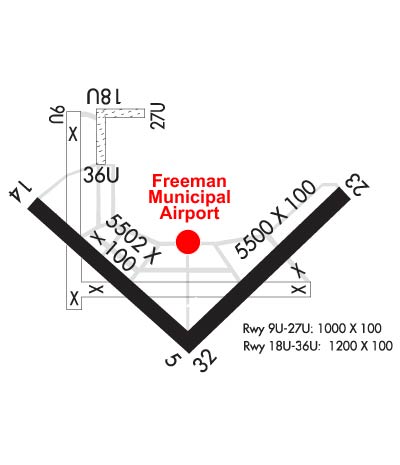
| Lat: N 3855.5 Long: W 08554.6 Elev: 583 Var: +02 Longest Runway: 6000 | ||
| AWOS: 119.42 CTAF: 122.8 | ||
| ||||||||||||||||||||||||||||||||||||||||||||||||||||||||||||||||||||
| ||||||||||||||||||||||||||||||||||||||||||||||||||||||||||||||||||||
| ||||||||||||||||||||||||||||||||||||||||||||||||||||||||||||||||||||
| ||||||||||||||||||||||||||||||||||||||||||||||||||||||||||||||||||||
| Rwy | Rwy | |||||||
| 6000x100 | 6000' | 108.50 - 046° | 6000x100 | 6000' | ||||
| 1104x100 | 1104' | 1104x100 | 1104' | |||||
| 5502x100 | 5502' | 5502x100 | 5502' | |||||
| 1215x100 | 1215' | 1215x100 | 1215' | |||||
| Runway ID | Single Wheel | Double Wheel | Double Tandem Wheel | Dual Double Wheel |
| 05/23 | 115,000 | 180,000 | 300,000 | N/A |
| 09U/27U | N/A | N/A | N/A | N/A |
| 14/32 | 20,000 | 35,000 | 50,000 | N/A |
| 18U/36U | N/A | N/A | N/A | N/A |
| These numbers are Advisory and are not limits. The Airport Manager should have more accurate Weight Limits | ||||
 Airport Diagram might not be current. | |
| Facility Name: | FREEMAN MUNI |
| City Name: | SEYMOUR |
| County: | JACKSON |
| State abbrev: | IN |
| State Name: | INDIANA |
| Ownership: | PUBLICLY OWNED |
| Use: | OPEN TO THE PUBLIC |
| Owner's Name: | SEYMOUR AIRPORT AUTHORITY |
| Address: | P.O. BOX 702 |
| SEYMOUR, IN 47274 | |
| Owner's Phone: | 812-522-2031 |
| Manager's Name: | DON FURLOW |
| Address: | P.O. BOX 702 |
| SEYMOUR, IN 47274 | |
| Phone: | 812-522-2031 |
| FAA Region: | GREAT LAKES |
| FAA Field Office: | CHI |
| Date | Sunrise | Sunset |
|---|---|---|
| 09/24/21 Friday | 7:33 | 19:38 |
| 09/25/21 Saturday | 7:34 | 19:36 |
| 09/26/21 Sunday | 7:35 | 19:35 |
| 09/27/21 Monday | 7:36 | 19:33 |
| 09/28/21 Tuesday | 7:37 | 19:31 |
| 09/29/21 Wednesday | 7:37 | 19:30 |
| 09/30/21 Thursday | 7:38 | 19:28 |
| 10/01/21 Friday | 7:39 | 19:27 |
| 10/02/21 Saturday | 7:40 | 19:25 |
| 10/03/21 Sunday | 7:41 | 19:24 |
| 10/04/21 Monday | 7:42 | 19:22 |
| 10/05/21 Tuesday | 7:43 | 19:20 |
| 10/06/21 Wednesday | 7:44 | 19:19 |
| 10/07/21 Thursday | 7:45 | 19:17 |
| Airport Attendance Schedule | 7 Days A Week 0800-1630 |
| Airport Status | OPERATIONAL (This Status can change at any time - please check NOTAMS) |
| Airport Lighting Schedule | ACTVT ODALS RWY 05 & 23; REIL RWY 05, 14, 23 & 32; PAPI RWY 05, 14, 23 & 32 - CTAF. MIRL RWY 05/23 & 14/32 PRESET ON. |
| Airport Storage Available | Tie Downs, Hanger |
| Extra Services Available | Air Freight, Crop Dusting, Cargo Handling, Flight Instruction, Aircraft Rental, Annual Surveying |
| Wind Indicator | YES - (lighted) |
| Control Tower | NO |
| CTAF Frequency | 122.800 |
| Unicom Frequency | 122.800 |
| Rotating Beacon Color | CLEAR-GREEN (Light Land Airport) |
| Segmented Circle | YES |
| Landing Fee | NO |
| Airport Inspected | STATE - performed by STATE AERONAUTICAL PERSONNEL |
| Inspection Date | 03/12/2019 |
| Type of Fuel Available | Grade 100LL, JET A (freeze point -40C); -10SELF SERVE AVBL 24 HR. |
| Airframe Repair Service | MINOR |
| Power Plant Repair Service | MINOR |
| Latitude | N3855.5 |
| Longitude | W08554.6 (ESTIMATED) |
| Arpt Elevation | 582ft (SURVEYED) |
| Magnetic Variation | 02W |
| 2 miles SW | of SEYMOUR |
| Traffic Pattern Altitude | |
| Sectional Chart | ST LOUIS |
| Operations (Reported) | Yearly | Avg. Daily |
|---|---|---|
| General Aviation Transient | 4366 | 12 |
| General Aviation Local | 11849 | 32 |
| Air Taxi | 4366 | 12 |
| Commerical | 0 | 0 |
| Commuter | 0 | 0 |
| Military | 205 | 1 |
| Aircraft based on Field | |
|---|---|
| General Aviation Singles | 41 |
| General Aviation Multi | 8 |
| Jet Aircraft | 0 |
| General Aviation Helicopters | 2 |
| Military Aircraft | 0 |
| Gliders | 15 |
| Ultralights | 0 |
| FSS on field | NO |
| FSS tie-in | TERRE HAUTE |
| FSS Phone | 1-800-WX-BRIEF |
| Who issues Notams | HUF |
| Notam D service at airport | YES |
| ARTCC Name | INDIANAPOLIS |
| Airport Certification | |
| Aircraft Rescue & Firefighting Index | None |
| Airport of Entry | No |
| Custom Landing Rights | No |
| Joint Civil/Military | No |
| Military Landing rights | YES |
| NATIONAL PLAN OF INTEGRATED AIRPORT SYSTEMS (NPIAS) |
| GRANT AGREEMENTS UNDER FAAP/ADAP/AIP |
| SURPLUS PROPERTY AGREEMENT UNDER PUBLIC LAW 289 |
| ASSURANCES PURSUANT TO TITLE VI, CIVIL RIGHTS ACT OF 1964 |
| RDO CTLD AIRPLANE OPS ON & INVOF ARPT DLY FM APR - OCT. |
| TWY LGTS FM INT 14/32 & 05/23 TO APRON ONLY. |
| FOR CD CTC INDIANAPOLIS ARTCC AT 317-247-2411. |
Airport Communications & Frequencies:
| |||||||||
| Runway: 05 | Runway: 23 | ||
| Mag heading: | 46° | Mag heading: | 226° |
| Rwy Slope: | .16% Up | Rwy Slope: | -.16% Down |
| Approach: | LOCALIZER | Approach: | |
| Pattern: | Left Traffic | Pattern: | Left Traffic |
| Markings: | NONPRECISION INSTRUMENT | Markings: | NONPRECISION INSTRUMENT |
| Marking Condition: | GOOD | Marking Condition: | GOOD |
| Arresting Dev: | Arresting Dev: | ||
| Lat & Long: | N3854.9 W08554.7 | Lat. & Long.: | N3855.6 W08553.8 |
| Elev: | 568.3 ft. MSL | Elev: | 577.7 ft. MSL |
| TCH: | 33 ft. AGL | TCH: | 33 ft. AGL |
| Visual Glide Path: | 3.00 degrees | Visual Glide Path: | 3.00 degrees |
| Displaced Threshold: | No | Displaced Threshold: | No |
| Touchdown Zone: | YES | Touchdown Zone: | YES |
| Touchdown Elev.: | 574.2 feet | Touchdown Elev.: | 579.9 feet |
| Visual Glide Slope: | 2-Light PAPI on LEFT side of Runway | Visual Glide Slope: | 2-Light PAPI on LEFT side of Runway |
| RVR Equipment: | RVR Equipment: | ||
| RVV Equipment: | NO | RVV Equipment: | NO |
| Approach Lights: | ODALS - omnidirectional approach lighting system | Approach Lights: | ODALS - omnidirectional approach lighting system |
| REIL: | YES | REIL: | YES |
| Centerline Lights: | NO | Centerline Lights: | NO |
| Touchdown lights: | NO | Touchdown lights: | NO |
| Runway Category: | Runway with a Non-precision Approach having visibility minimums greater than 3/4 mile | Runway Category: | Runway with a Non-precision Approach having visibility minimums greater than 3/4 mile |
| Declared Distances: | Declared Distances: |
| Runway: 09U | Runway: 27U | ||
| Mag heading: | 92° | Mag heading: | 272° |
| Rwy Slope: | -.35% Down | Rwy Slope: | .35% Up |
| Approach: | Approach: | ||
| Pattern: | Left Traffic | Pattern: | Left Traffic |
| Markings: | Markings: | ||
| Marking Condition: | Marking Condition: | ||
| Arresting Dev: | Arresting Dev: | ||
| Lat & Long: | N3856.1 W08555.0 | Lat. & Long.: | N3856.1 W08554.7 |
| Elev: | 569.3 ft. MSL | Elev: | 565.4 ft. MSL |
| TCH: | TCH: | ||
| Visual Glide Path: | Visual Glide Path: | ||
| Displaced Threshold: | No | Displaced Threshold: | No |
| Touchdown Zone: | YES | Touchdown Zone: | YES |
| Touchdown Elev.: | 569.9 feet | Touchdown Elev.: | 569.9 feet |
| Visual Glide Slope: | Visual Glide Slope: | ||
| RVR Equipment: | RVR Equipment: | ||
| RVV Equipment: | NO | RVV Equipment: | NO |
| Approach Lights: | Approach Lights: | ||
| REIL: | NO | REIL: | NO |
| Centerline Lights: | NO | Centerline Lights: | NO |
| Touchdown lights: | NO | Touchdown lights: | NO |
| Runway Category: | Runway with a Visual Approach | Runway Category: | Runway with a Visual Approach |
| Declared Distances: | Declared Distances: | ||
| Obstructions: | 30 FT PLINE MKD WITH BALLS 700 FT FM RWY END. | Obstructions: | |
| Marked: | NOT Marked/Lighted | Marked: | |
| Clearance slope: | 20:1 | Clearance slope: | 20:1 |
| Obstruction height: | Obstruction height: | ||
| Dist. from runway: | Dist. from runway: | ||
| Centerline offset: | Centerline offset: | ||
| Comments: | Comments: |
| Runway: 14 | Runway: 32 | ||
| Mag heading: | 136° | Mag heading: | 316° |
| Rwy Slope: | -.23% Down | Rwy Slope: | .23% Up |
| Approach: | Approach: | ||
| Pattern: | Left Traffic | Pattern: | Left Traffic |
| Markings: | NONPRECISION INSTRUMENT | Markings: | NONPRECISION INSTRUMENT |
| Marking Condition: | GOOD | Marking Condition: | GOOD |
| Arresting Dev: | Arresting Dev: | ||
| Lat & Long: | N3855.7 W08555.3 | Lat. & Long.: | N3855.1 W08554.4 |
| Elev: | 582.7 ft. MSL | Elev: | 570.3 ft. MSL |
| TCH: | 24 ft. AGL | TCH: | 38 ft. AGL |
| Visual Glide Path: | 3.00 degrees | Visual Glide Path: | 3.00 degrees |
| Displaced Threshold: | No | Displaced Threshold: | No |
| Touchdown Zone: | YES | Touchdown Zone: | YES |
| Touchdown Elev.: | 582.7 feet | Touchdown Elev.: | 573.9 feet |
| Visual Glide Slope: | 2-Light PAPI on LEFT side of Runway | Visual Glide Slope: | 2-Light PAPI on LEFT side of Runway |
| RVR Equipment: | RVR Equipment: | ||
| RVV Equipment: | NO | RVV Equipment: | NO |
| Approach Lights: | Approach Lights: | ||
| REIL: | YES | REIL: | YES |
| Centerline Lights: | NO | Centerline Lights: | NO |
| Touchdown lights: | NO | Touchdown lights: | NO |
| Runway Category: | Runway with a Non-precision Approach having visibility minimums greater than 3/4 mile | Runway Category: | Runway with a Non-precision Approach having visibility minimums greater than 3/4 mile |
| Declared Distances: | Declared Distances: | ||
| Obstructions: | CROPS | Obstructions: | |
| Marked: | NOT Marked/Lighted | Marked: | |
| Clearance slope: | 24:1 | Clearance slope: | 34:1 |
| Obstruction height: | 10 feet AGL | Obstruction height: | |
| Dist. from runway: | 440 feet | Dist. from runway: | |
| Centerline offset: | B | Centerline offset: | |
| Comments: | Comments: |
| Runway: 18U | Runway: 36U | ||
| Mag heading: | 182° | Mag heading: | 2° |
| Rwy Slope: | .30% Up | Rwy Slope: | -.30% Down |
| Approach: | Approach: | ||
| Pattern: | Left Traffic | Pattern: | Right Traffic |
| Markings: | Markings: | ||
| Marking Condition: | Marking Condition: | ||
| Arresting Dev: | Arresting Dev: | ||
| Lat & Long: | N3856.1 W08554.9 | Lat. & Long.: | N3855.9 W08554.9 |
| Elev: | 569.5 ft. MSL | Elev: | 573.1 ft. MSL |
| TCH: | TCH: | ||
| Visual Glide Path: | Visual Glide Path: | ||
| Displaced Threshold: | No | Displaced Threshold: | No |
| Touchdown Zone: | YES | Touchdown Zone: | YES |
| Touchdown Elev.: | 573.1 feet | Touchdown Elev.: | 573.1 feet |
| Visual Glide Slope: | Visual Glide Slope: | ||
| RVR Equipment: | RVR Equipment: | ||
| RVV Equipment: | NO | RVV Equipment: | NO |
| Approach Lights: | Approach Lights: | ||
| REIL: | NO | REIL: | NO |
| Centerline Lights: | NO | Centerline Lights: | NO |
| Touchdown lights: | NO | Touchdown lights: | NO |
| Runway Category: | Runway with a Visual Approach | Runway Category: | Runway with a Visual Approach |
| Declared Distances: | Declared Distances: | ||
| Obstructions: | 20 FT BLDG 550 FT FM RWY END. | Obstructions: | |
| Marked: | NOT Marked/Lighted | Marked: | |
| Clearance slope: | 20:1 | Clearance slope: | 20:1 |
| Obstruction height: | Obstruction height: | ||
| Dist. from runway: | Dist. from runway: | ||
| Centerline offset: | Centerline offset: | ||
| Comments: | Comments: |
Thanks for using FltPlan.com
all rights reserved © 1999-2021 by Flight Plan LLC