
| NORTHEAST FLORIDA RGNL ST AUGUSTINE FL |
| |
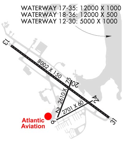
| Lat: N 2957.6 Long: W 08120.4 Elev: 10 Var: +04 Longest Runway: 7997 | ||
| Dept. ATIS: 119.62 Arr. ATIS: 119.62 AWOS: 119.62 Ground: 121.17 Tower: 127.62 | ||
| ||||||||||||||||||||||||||||||||||||||||||||||||||||||||||||||||||||
| ||||||||||||||||||||||||||||||||||||||||||||||||||||||||||||||||||||
| ||||||||||||||||||||||||||||||||||||||||||||||||||||||||||||||||||||
| ||||||||||||||||||||||||||||||||||||||||||||||||||||||||||||||||||||
| ||||||||||||||||||||||||||||||||||||||||||||||||||||||||||||||||||||
| Rwy | Rwy | |||||||
| 2609x75 | 2609' | 2609x75 | 2609' | |||||
| 2701x60 | 2701' | 2701x60 | 2701' | |||||
| 5000x1000 | 5000' | 5000x1000 | 5000' | |||||
| 7997x150 | 6941' | 7997x150 | 7195' | 111.10 - 311° | ||||
| 12000x1000 | 12000' | 12000x1000 | 12000' | |||||
| 12000x500 | 12000' | 12000x500 | 12000' | |||||
| Runway ID | Single Wheel | Double Wheel | Double Tandem Wheel | Dual Double Wheel |
| 02/20 | 100,000 | 203,500 | N/A | N/A |
| 06/24 | 46,500 | 85,000 | N/A | N/A |
| 12W/30W | N/A | N/A | N/A | N/A |
| 13/31 | 100,000 | 280,000 | 560,000 | 1,120,000 |
| 17W/35W | N/A | N/A | N/A | N/A |
| 18W/36W | N/A | N/A | N/A | N/A |
| These numbers are Advisory and are not limits. The Airport Manager should have more accurate Weight Limits | ||||
 Airport Diagram might not be current. | |
| Facility Name: | NORTHEAST FLORIDA RGNL |
| City Name: | ST AUGUSTINE |
| County: | ST JOHNS |
| State abbrev: | FL |
| State Name: | FLORIDA |
| Ownership: | PUBLICLY OWNED |
| Use: | OPEN TO THE PUBLIC |
| Owner's Name: | ST AUGUSTINE ARPT AUTH |
| Address: | 4796 US 1 NORTH |
| ST AUGUSTINE, FL 32095 | |
| Owner's Phone: | 904-209-0090 |
| Manager's Name: | ED WUELLNER |
| Address: | 4796 US 1 NORTH |
| ST AUGUSTINE, FL 32095 | |
| Phone: | 904-209-0090 |
| FAA Region: | SOUTHERN |
| FAA Field Office: | ORL |
| Date | Sunrise | Sunset |
|---|---|---|
| 09/24/21 Friday | 7:15 | 19:20 |
| 09/25/21 Saturday | 7:15 | 19:18 |
| 09/26/21 Sunday | 7:16 | 19:17 |
| 09/27/21 Monday | 7:16 | 19:16 |
| 09/28/21 Tuesday | 7:17 | 19:15 |
| 09/29/21 Wednesday | 7:17 | 19:14 |
| 09/30/21 Thursday | 7:18 | 19:12 |
| 10/01/21 Friday | 7:19 | 19:11 |
| 10/02/21 Saturday | 7:19 | 19:10 |
| 10/03/21 Sunday | 7:20 | 19:09 |
| 10/04/21 Monday | 7:20 | 19:07 |
| 10/05/21 Tuesday | 7:21 | 19:06 |
| 10/06/21 Wednesday | 7:21 | 19:05 |
| 10/07/21 Thursday | 7:22 | 19:04 |
| Airport Attendance Schedule | 7 Days A Week 0600-2400 |
| Airport Status | OPERATIONAL (This Status can change at any time - please check NOTAMS) |
| Airport Lighting Schedule | ACTVT MALSR RWY 31; HIRL RWY 13/31; MIRL RWY 06/24 & 2/20 - CTAF. RWY 06 PAPI OPR CONSLY. |
| Airport Storage Available | Tie Downs, Hanger |
| Extra Services Available | Air Ambulance, Avionics, Charter, Flight Instruction, Aircraft Rental, Aircraft Sales |
| Wind Indicator | YES - (lighted) |
| Control Tower | YES |
| CTAF Frequency | 127.625 |
| Unicom Frequency | 122.950 |
| Rotating Beacon Color | CLEAR-GREEN (Light Land Airport) |
| Segmented Circle | YES |
| Landing Fee | NO |
| Airport Inspected | FEDERAL - performed by FAA AIRPORTS FIELD PERSONNEL |
| Inspection Date | 10/25/2019 |
| Type of Fuel Available | Grade 100LL, JET A (freeze point -40C); -A SELF SVC FUEL AVBL 24 HRS WITH CREDIT CARD.; -10JET SINGLE POINT REFUELING AVBL. |
| Airframe Repair Service | MAJOR |
| Power Plant Repair Service | MAJOR |
| Latitude | N2957.6 |
| Longitude | W08120.4 (ESTIMATED) |
| Arpt Elevation | 9ft (SURVEYED) |
| Magnetic Variation | 04W |
| 4 miles N | of ST AUGUSTINE |
| Traffic Pattern Altitude | |
| Sectional Chart | JACKSONVILLE |
| Operations (Reported) | Yearly | Avg. Daily |
|---|---|---|
| General Aviation Transient | 46570 | 128 |
| General Aviation Local | 65497 | 179 |
| Air Taxi | 3824 | 10 |
| Commerical | 0 | 0 |
| Commuter | 0 | 0 |
| Military | 2029 | 6 |
| Aircraft based on Field | |
|---|---|
| General Aviation Singles | 0 |
| General Aviation Multi | 0 |
| Jet Aircraft | 0 |
| General Aviation Helicopters | 0 |
| Military Aircraft | 22 |
| Gliders | 0 |
| Ultralights | 0 |
| FSS on field | NO |
| FSS tie-in | GAINESVILLE |
| FSS Phone | 1-800-WX-BRIEF |
| Who issues Notams | SGJ |
| Notam D service at airport | YES |
| ARTCC Name | JACKSONVILLE |
| Airport Certification | AIRPORT RECEIVING SCHEDULED AIR CARRIER SERVICE FROM CARRIERS CERTIFICATED BY THE CIVIL AERONAUTICS BOARD; PPR 24 HRS FOR UNSKED ACR OPS WITH MORE THAN 30 PAX SEATS CALL AMGR 904-209-0090. |
| Aircraft Rescue & Firefighting Index | AIRPORT HAS A CERTIFICATE UNDER CFR PART 139 |
| Airport of Entry | No |
| Custom Landing Rights | No; US CUSTOMS USER FEE ARPT. |
| Joint Civil/Military | No |
| Military Landing rights | YES |
| NATIONAL PLAN OF INTEGRATED AIRPORT SYSTEMS (NPIAS) |
| GRANT AGREEMENTS UNDER FAAP/ADAP/AIP |
| SURPLUS PROPERTY AGREEMENT UNDER REGULATION 16-WAA |
| ASSURANCES PURSUANT TO TITLE VI, CIVIL RIGHTS ACT OF 1964 |
| AGREEMENT UNDER DLAND OR DCLA HAS EXPIRED. |
| AEROBATIC ACT E SIDE OF RWY 13/31 CTC TWR FOR TFC & GNV RADIO FOR TIMES. |
| FICON NOT MNTD 2100 - 0700 LCL. |
| FOR CD IF UNA TO CTC ON FSS FREQ, CTC JACKSONVILLE APCH AT 904-741-0284. |
| RWYS 06/24, 02/20, 12W/30W, 17W/35W & 18W/36W NOT AVBL FOR SKED ACR OPNS WITH MORE THAN 9 PAX SEATS OR UNSKED ACR AT LEAST 31 PAX SEATS |
Airport Communications & Frequencies:
| ||||||||||||||||||||
| Runway: 02 | Runway: 20 | ||
| Mag heading: | 25° | Mag heading: | 205° |
| Rwy Slope: | -.14% Down | Rwy Slope: | .14% Up |
| Approach: | Approach: | ||
| Pattern: | Left Traffic | Pattern: | Left Traffic |
| Markings: | BASIC | Markings: | BASIC |
| Marking Condition: | GOOD | Marking Condition: | GOOD |
| Arresting Dev: | Arresting Dev: | ||
| Lat & Long: | N2957.3 W08120.5 | Lat. & Long.: | N2957.7 W08120.3 |
| Elev: | 9.1 ft. MSL | Elev: | 5.5 ft. MSL |
| TCH: | TCH: | ||
| Visual Glide Path: | Visual Glide Path: | ||
| Displaced Threshold: | No | Displaced Threshold: | No |
| Touchdown Zone: | YES | Touchdown Zone: | YES |
| Touchdown Elev.: | 9.3 feet | Touchdown Elev.: | 9.3 feet |
| Visual Glide Slope: | Visual Glide Slope: | ||
| RVR Equipment: | RVR Equipment: | ||
| RVV Equipment: | NO | RVV Equipment: | NO |
| Approach Lights: | Approach Lights: | ||
| REIL: | NO | REIL: | NO |
| Centerline Lights: | NO | Centerline Lights: | NO |
| Touchdown lights: | NO | Touchdown lights: | NO |
| Runway Category: | Runway with a Visual Approach | Runway Category: | Runway with a Visual Approach |
| Declared Distances: | TORA:2610' TODA:2610' ASDA:2610' LDA:2610' | Declared Distances: | TORA:2610' TODA:2610' ASDA:2610' LDA:2610' |
| Obstructions: | TREES | Obstructions: | |
| Marked: | NOT Marked/Lighted | Marked: | |
| Clearance slope: | 15:1 | Clearance slope: | 50:1 |
| Obstruction height: | 76 feet AGL | Obstruction height: | |
| Dist. from runway: | 1345 feet | Dist. from runway: | |
| Centerline offset: | 75 left of centerline | Centerline offset: | |
| Comments: | Comments: |
| Runway: 06 | Runway: 24 | ||
| Mag heading: | 66° | Mag heading: | 246° |
| Rwy Slope: | -.14% Down | Rwy Slope: | .14% Up |
| Approach: | Approach: | ||
| Pattern: | Left Traffic | Pattern: | Left Traffic |
| Markings: | BASIC | Markings: | BASIC |
| Marking Condition: | GOOD | Marking Condition: | GOOD |
| Arresting Dev: | Arresting Dev: | ||
| Lat & Long: | N2957.2 W08120.5 | Lat. & Long.: | N2957.4 W08120.0 |
| Elev: | 9.6 ft. MSL | Elev: | 5.9 ft. MSL |
| TCH: | 47 ft. AGL | TCH: | |
| Visual Glide Path: | 3.25 degrees | Visual Glide Path: | |
| Displaced Threshold: | No | Displaced Threshold: | No |
| Touchdown Zone: | YES | Touchdown Zone: | YES |
| Touchdown Elev.: | 9.7 feet | Touchdown Elev.: | 9.7 feet |
| Visual Glide Slope: | 2-Light PAPI on LEFT side of Runway | Visual Glide Slope: | |
| RVR Equipment: | RVR Equipment: | ||
| RVV Equipment: | NO | RVV Equipment: | NO |
| Approach Lights: | Approach Lights: | ||
| REIL: | NO | REIL: | NO |
| Centerline Lights: | NO | Centerline Lights: | NO |
| Touchdown lights: | NO | Touchdown lights: | NO |
| Runway Category: | Runway with a Visual Approach | Runway Category: | Runway with a Visual Approach |
| Declared Distances: | TORA:2701' TODA:2701' ASDA:2701' LDA:2701' | Declared Distances: | TORA:2701' TODA:2701' ASDA:2701' LDA:2701' |
| Obstructions: | TREES | Obstructions: | |
| Marked: | NOT Marked/Lighted | Marked: | |
| Clearance slope: | 16:1 | Clearance slope: | 50:1 |
| Obstruction height: | 53 feet AGL | Obstruction height: | |
| Dist. from runway: | 1055 feet | Dist. from runway: | |
| Centerline offset: | 145 right of centerline | Centerline offset: | |
| Comments: | Comments: |
| Runway: 12W | Runway: 30W | ||
| Mag heading: | N/A | Mag heading: | N/A |
| Approach: | Approach: | ||
| Pattern: | Left Traffic | Pattern: | Left Traffic |
| Markings: | Markings: | ||
| Marking Condition: | Marking Condition: | ||
| Arresting Dev: | Arresting Dev: | ||
| Lat & Long: | Lat. & Long.: | ||
| Elev: | N/A | Elev: | N/A |
| TCH: | TCH: | ||
| Visual Glide Path: | Visual Glide Path: | ||
| Displaced Threshold: | No | Displaced Threshold: | No |
| Touchdown Zone: | NO | Touchdown Zone: | NO |
| Touchdown Elev.: | Touchdown Elev.: | ||
| Visual Glide Slope: | Visual Glide Slope: | ||
| RVR Equipment: | RVR Equipment: | ||
| RVV Equipment: | NO | RVV Equipment: | NO |
| Approach Lights: | Approach Lights: | ||
| REIL: | NO | REIL: | NO |
| Centerline Lights: | NO | Centerline Lights: | NO |
| Touchdown lights: | NO | Touchdown lights: | NO |
| Runway Category: | Runway with a Visual Approach | Runway Category: | Runway with a Visual Approach |
| Declared Distances: | Declared Distances: |
| Runway: 13 | Runway: 31 | ||
| Mag heading: | 130° | Mag heading: | 310° |
| Rwy Slope: | -.05% Down | Rwy Slope: | .05% Up |
| Approach: | Approach: | ILS/DME | |
| Pattern: | Left Traffic | Pattern: | Left Traffic |
| Markings: | PRECISION INSTRUMENT | Markings: | PRECISION INSTRUMENT |
| Marking Condition: | GOOD | Marking Condition: | GOOD |
| Arresting Dev: | Arresting Dev: | ||
| Lat & Long: | N2958.0 W08121.0 | Lat. & Long.: | N2957.3 W08119.8 |
| Elev: | 9.5 ft. MSL | Elev: | 5.7 ft. MSL |
| TCH: | 44 ft. AGL | TCH: | 54 ft. AGL |
| Visual Glide Path: | 3.00 degrees | Visual Glide Path: | 3.00 degrees |
| Displaced Threshold: | 1056 feet | Displaced Threshold: | 802 feet |
| Touchdown Zone: | YES | Touchdown Zone: | YES |
| Touchdown Elev.: | 9.8 feet | Touchdown Elev.: | 7.5 feet |
| Visual Glide Slope: | 4-BOX VASI ON LEFT SIDE OF RUNWAY | Visual Glide Slope: | 4-Light PAPI on LEFT side of Runway |
| RVR Equipment: | RVR Equipment: | ||
| RVV Equipment: | NO | RVV Equipment: | NO |
| Approach Lights: | Approach Lights: | MALSR - 1,400 foot medium intensity approach lighting system with runway alignment indicator lights | |
| REIL: | NO | REIL: | NO |
| Centerline Lights: | YES | Centerline Lights: | YES |
| Touchdown lights: | NO | Touchdown lights: | NO |
| Runway Category: | Runway with a Non-precision Approach having visibility minimums greater than 3/4 mile | Runway Category: | Precision Instrument Runway |
| Declared Distances: | TORA:8001' TODA:8001' ASDA:7202' LDA:6144' | Declared Distances: | TORA:8001' TODA:8001' ASDA:6730' LDA:5925' |
| Obstructions: | ROAD | Obstructions: | |
| Marked: | NOT Marked/Lighted | Marked: | |
| Clearance slope: | RWY 13 APCH SLP 34:1 TO MKD DSPCD THR. | Clearance slope: | 50:1 |
| Obstruction height: | 15 feet AGL | Obstruction height: | |
| Dist. from runway: | 200 feet | Dist. from runway: | |
| Centerline offset: | 150 right of centerline | Centerline offset: | |
| Comments: | ROAD 15 FT TALL 200 FT BFR AER OF RWY 13 150 RIGHT OF CNTRLN. | Comments: |
| Runway: 17W | Runway: 35W | ||
| Mag heading: | N/A | Mag heading: | N/A |
| Approach: | Approach: | ||
| Pattern: | Left Traffic | Pattern: | Left Traffic |
| Markings: | Markings: | ||
| Marking Condition: | Marking Condition: | ||
| Arresting Dev: | Arresting Dev: | ||
| Lat & Long: | Lat. & Long.: | ||
| Elev: | N/A | Elev: | N/A |
| TCH: | TCH: | ||
| Visual Glide Path: | Visual Glide Path: | ||
| Displaced Threshold: | No | Displaced Threshold: | No |
| Touchdown Zone: | NO | Touchdown Zone: | NO |
| Touchdown Elev.: | Touchdown Elev.: | ||
| Visual Glide Slope: | Visual Glide Slope: | ||
| RVR Equipment: | RVR Equipment: | ||
| RVV Equipment: | NO | RVV Equipment: | NO |
| Approach Lights: | Approach Lights: | ||
| REIL: | NO | REIL: | NO |
| Centerline Lights: | NO | Centerline Lights: | NO |
| Touchdown lights: | NO | Touchdown lights: | NO |
| Runway Category: | Runway with a Visual Approach | Runway Category: | Runway with a Visual Approach |
| Declared Distances: | Declared Distances: |
| Runway: 18W | Runway: 36W | ||
| Mag heading: | N/A | Mag heading: | N/A |
| Approach: | Approach: | ||
| Pattern: | Left Traffic | Pattern: | Left Traffic |
| Markings: | Markings: | ||
| Marking Condition: | Marking Condition: | ||
| Arresting Dev: | Arresting Dev: | ||
| Lat & Long: | Lat. & Long.: | ||
| Elev: | N/A | Elev: | N/A |
| TCH: | TCH: | ||
| Visual Glide Path: | Visual Glide Path: | ||
| Displaced Threshold: | No | Displaced Threshold: | No |
| Touchdown Zone: | NO | Touchdown Zone: | NO |
| Touchdown Elev.: | Touchdown Elev.: | ||
| Visual Glide Slope: | Visual Glide Slope: | ||
| RVR Equipment: | RVR Equipment: | ||
| RVV Equipment: | NO | RVV Equipment: | NO |
| Approach Lights: | Approach Lights: | ||
| REIL: | NO | REIL: | NO |
| Centerline Lights: | NO | Centerline Lights: | NO |
| Touchdown lights: | NO | Touchdown lights: | NO |
| Runway Category: | Runway with a Visual Approach | Runway Category: | Runway with a Visual Approach |
| Declared Distances: | Declared Distances: |
Thanks for using FltPlan.com
all rights reserved © 1999-2021 by Flight Plan LLC


