
| MCNARY FLD SALEM OR |
| |
| Lat: N 4454.6 Long: W 12300.2 Elev: 213 Var: -17 Longest Runway: 5811 | ||
| Dept. ATIS: 124.55 Arr. ATIS: 124.55 AWOS: 124.55 Ground: 121.9 Tower: 119.1 | ||
| ||||||||||||||||||||||||||||||||||||||||||||
| ||||||||||||||||||||||||||||||||||||||||||||
| ||||||||||||||||||||||||||||||||||||||||||||
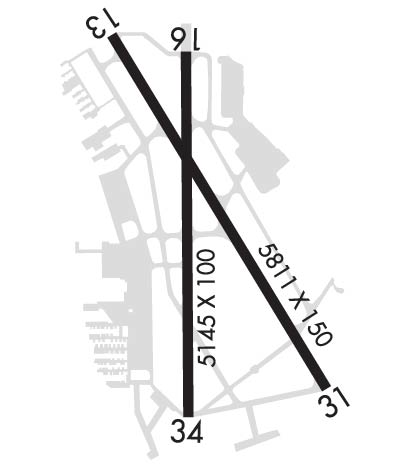
| Rwy | Rwy | |||||||
| 5811x150 | 5811' | 5811x150 | 5811' | 110.30 - 313° | ||||
| 5146x100 | 5146' | 5146x100 | 5146' | |||||
| Runway ID | Single Wheel | Double Wheel | Double Tandem Wheel | Dual Double Wheel |
| 13/31 | 120,000 | 189,000 | 280,000 | 759,000 |
| 16/34 | 39,500 | 52,000 | N/A | N/A |
| H1 | N/A | N/A | N/A | N/A |
| These numbers are Advisory and are not limits. The Airport Manager should have more accurate Weight Limits | ||||
 Airport Diagram might not be current. | |
| Facility Name: | MCNARY FLD |
| City Name: | SALEM |
| County: | MARION |
| State abbrev: | OR |
| State Name: | OREGON |
| Ownership: | PUBLICLY OWNED |
| Use: | OPEN TO THE PUBLIC |
| Owner's Name: | CITY OF SALEM |
| Address: | 555 LIBERTY ST SE RM 220 |
| SALEM, OR 97301 | |
| Owner's Phone: | 503-588-6255 |
| Manager's Name: | JOHN PASKELL |
| Address: | 2990 25TH ST SE |
| SALEM, OR 97302 | |
| Phone: | 503-589-2057 |
| FAA Region: | NORTHWEST MOUNTAIN |
| FAA Field Office: | SEA |
| Date | Sunrise | Sunset |
|---|---|---|
| 03/20/25 Thursday | 7:15 | 19:24 |
| 03/21/25 Friday | 7:14 | 19:26 |
| 03/22/25 Saturday | 7:12 | 19:27 |
| 03/23/25 Sunday | 7:10 | 19:28 |
| 03/24/25 Monday | 7:08 | 19:30 |
| 03/25/25 Tuesday | 7:06 | 19:31 |
| 03/26/25 Wednesday | 7:04 | 19:32 |
| 03/27/25 Thursday | 7:02 | 19:33 |
| 03/28/25 Friday | 7:00 | 19:35 |
| 03/29/25 Saturday | 6:59 | 19:36 |
| 03/30/25 Sunday | 6:57 | 19:37 |
| 03/31/25 Monday | 6:55 | 19:38 |
| 04/01/25 Tuesday | 6:53 | 19:40 |
| 04/02/25 Wednesday | 6:51 | 19:41 |
| Airport Attendance Schedule | MON-FRI 0700-1900, SAT-SUN 0700-1700 |
| Airport Status | OPERATIONAL (This Status can change at any time - please check NOTAMS) |
| Airport Lighting Schedule | WHEN ATCT CLSD ACTVT MALSR RWY 31; ODAL RWY 13; REIL RWY 13, 16, 34; HIRL RWY 13/31; MIRL RWY 16/34 - CTAF. REIL RWY 16, PAPI RWY 16 & 34 & BCN OTS INDEFLY. |
| Airport Storage Available | Tie Downs, Hanger |
| Extra Services Available | Air Freight, Avionics, Charter, Flight Instruction, Aircraft Rental, Aircraft Sales |
| Wind Indicator | YES - (lighted) |
| Control Tower | YES |
| CTAF Frequency | 119.100 |
| Unicom Frequency | 122.950 |
| Rotating Beacon Color | WG |
| Segmented Circle | YES |
| Landing Fee | NO |
| Airport Inspected | FEDERAL - performed by FAA AIRPORTS FIELD PERSONNEL |
| Inspection Date | 11/21/2024 |
| Type of Fuel Available | Grade 100LL, JET A (freeze point -40C); -A AFT HR JET A PPR - 503-508-4178 OR 503-364-4158.; -10100 LL SELF SVC H24. |
| Airframe Repair Service | MAJOR |
| Power Plant Repair Service | MAJOR |
| Latitude | N4454.6 |
| Longitude | W12300.2 (ESTIMATED) |
| Arpt Elevation | 213ft (SURVEYED) |
| Magnetic Variation | 17E |
| 2 miles SE | of SALEM |
| Traffic Pattern Altitude | |
| Sectional Chart | SEATTLE |
| Operations (Reported) | Yearly | Avg. Daily |
|---|---|---|
| General Aviation Transient | 0 | 0 |
| General Aviation Local | 0 | 0 |
| Air Taxi | 0 | 0 |
| Commerical | 0 | 0 |
| Commuter | 0 | 0 |
| Military | 0 | 0 |
| Aircraft based on Field | |
|---|---|
| General Aviation Singles | 0 |
| General Aviation Multi | 0 |
| Jet Aircraft | 0 |
| General Aviation Helicopters | 0 |
| Military Aircraft | 0 |
| Gliders | 0 |
| Ultralights | 0 |
| FSS on field | NO |
| FSS tie-in | MC MINNVILLE |
| FSS Phone | 1-800-WX-BRIEF |
| Who issues Notams | SLE |
| Notam D service at airport | YES |
| ARTCC Name | SEATTLE |
| Airport Certification | AIRPORT RECEIVING SCHEDULED AIR CARRIER SERVICE FROM CARRIERS CERTIFICATED BY THE CIVIL AERONAUTICS BOARD; PPR FOR UNSKED ACR OPS GTR THAN 30 PAX SEATS - AMGR. |
| Aircraft Rescue & Firefighting Index | AIRPORT HAS A CERTIFICATE UNDER CFR PART 139 |
| Airport of Entry | No |
| Custom Landing Rights | No |
| Joint Civil/Military | No |
| Military Landing rights | YES |
| NATIONAL PLAN OF INTEGRATED AIRPORT SYSTEMS (NPIAS) |
| GRANT AGREEMENTS UNDER FAAP/ADAP/AIP |
| SURPLUS PROPERTY AGREEMENT UNDER PUBLIC LAW 289 |
| ASSURANCES PURSUANT TO TITLE VI, CIVIL RIGHTS ACT OF 1964 |
| AGREEMENT UNDER DLAND OR DCLA HAS EXPIRED. |
| ARNG: 1500-0030Z++ MON-FRI EXC HOL. TSNT PPR - DSN 355-1401, C971-355-1401; TSNT ALERT SVC & PRKG NA. ROTARY WING NOISE ABATEMENT PROC IN EFCT. TSNT ROTARY WING USE SANTIAM ARR/DEP. ARNG LGT ACFT PAX SVC VIP PAD S END OF MIL RAMP. DURG DUTY HR CTC GUARD OPS 10 MIN OUT - 40.90, 142.8, 248.5. OSA OPS - D355-1409, C971-355-1409. |
| FOR CD IF UNA TO CTC ON FSS FREQ, CTC SEATTLE ARTCC AT 253-351-3694. |
| CLSD AFT HVY SNOW. ARPT COND UNMNT 1600L-0800L & WKEND. |
| BIRD HAZARD: WATERFOWL INVOF ARPT; GEESE TRSN CLASS D AT TPA OCT-MAY. |
| TWY A FM TWY L TO L9 NOT VSB FM ATCT. |
| ACR RAMP PRKG PPR - AMGR. |
| NOISE ABATMENT PROC IN EFCT; AVOID OTFC RESIDENTIAL AREAS. |
| RISING TRRN & TREES W & S OF ARPT & RWY 34 EXTDD CNTRLN. TREES ON RWY 16 EXTDD CNTRLN. NGT OPS NOT RCMD BOTH RWYS. |
| RWY 13/3 1 PCR VALUE: 510/F/C/X/T |
Airport Communications & Frequencies:
| |||||||||||||||||||||
| Runway: 13 | Runway: 31 | ||
| Mag heading: | 133° | Mag heading: | 313° |
| Rwy Slope: | .33% Up | Rwy Slope: | -.33% Down |
| Approach: | Approach: | ILS/DME | |
| Pattern: | Left Traffic | Pattern: | Left Traffic |
| Markings: | NONPRECISION INSTRUMENT | Markings: | PRECISION INSTRUMENT |
| Marking Condition: | GOOD | Marking Condition: | GOOD |
| Arresting Dev: | Arresting Dev: | ||
| Lat & Long: | N4455.0 W12300.4 | Lat. & Long.: | N4454.2 W12259.8 |
| Elev: | 194.5 ft. MSL | Elev: | 213.4 ft. MSL |
| TCH: | 50 ft. AGL | TCH: | |
| Visual Glide Path: | 3.00 degrees | Visual Glide Path: | |
| Displaced Threshold: | No | Displaced Threshold: | No |
| Touchdown Zone: | YES | Touchdown Zone: | YES |
| Touchdown Elev.: | 203.6 feet | Touchdown Elev.: | 213.4 feet |
| Visual Glide Slope: | 4-BOX VASI ON LEFT SIDE OF RUNWAY | Visual Glide Slope: | |
| RVR Equipment: | ROLLOUT | RVR Equipment: | TOUCHDOWN |
| RVV Equipment: | NO | RVV Equipment: | NO |
| Approach Lights: | ODALS - omnidirectional approach lighting system | Approach Lights: | MALSR - 1,400 foot medium intensity approach lighting system with runway alignment indicator lights |
| REIL: | YES | REIL: | NO |
| Centerline Lights: | NO | Centerline Lights: | NO |
| Touchdown lights: | NO | Touchdown lights: | NO |
| Runway Category: | D | Runway Category: | Precision Instrument Runway |
| Declared Distances: | TORA:5811' TODA:5811' ASDA:5811' LDA:5811' | Declared Distances: | TORA:5811' TODA:5811' ASDA:5811' LDA:5811' |
| Obstructions: | ROAD | Obstructions: | TREE |
| Marked: | NOT Marked/Lighted | Marked: | NOT Marked/Lighted |
| Clearance slope: | 36:1 | Clearance slope: | 30:1 |
| Obstruction height: | 11 feet AGL | Obstruction height: | 459 feet AGL |
| Dist. from runway: | 600 feet | Dist. from runway: | 15950 feet |
| Centerline offset: | 550 right of centerline | Centerline offset: | 1900 feet left of centerline |
| Comments: | Comments: |
| Runway: 16 | Runway: 34 | ||
| Mag heading: | 164° | Mag heading: | 344° |
| Rwy Slope: | .30% Up | Rwy Slope: | -.30% Down |
| Approach: | Approach: | ||
| Pattern: | Left Traffic | Pattern: | Left Traffic |
| Markings: | NONPRECISION INSTRUMENT | Markings: | NONPRECISION INSTRUMENT |
| Marking Condition: | GOOD | Marking Condition: | GOOD |
| Arresting Dev: | Arresting Dev: | ||
| Lat & Long: | N4455.0 W12300.2 | Lat. & Long.: | N4454.1 W12300.2 |
| Elev: | 195.7 ft. MSL | Elev: | 210.9 ft. MSL |
| TCH: | 38 ft. AGL | TCH: | 42 ft. AGL |
| Visual Glide Path: | 3.00 degrees | Visual Glide Path: | 4.00 degrees |
| Displaced Threshold: | No | Displaced Threshold: | No |
| Touchdown Zone: | YES | Touchdown Zone: | YES |
| Touchdown Elev.: | 204.0 feet | Touchdown Elev.: | 210.9 feet |
| Visual Glide Slope: | 4-Light PAPI on LEFT side of Runway | Visual Glide Slope: | 4-Light PAPI on LEFT side of Runway |
| RVR Equipment: | RVR Equipment: | ||
| RVV Equipment: | NO | RVV Equipment: | NO |
| Approach Lights: | Approach Lights: | ||
| REIL: | YES | REIL: | YES |
| Centerline Lights: | NO | Centerline Lights: | NO |
| Touchdown lights: | NO | Touchdown lights: | NO |
| Runway Category: | Runway with a Visual Approach | Runway Category: | Runway with a Visual Approach |
| Declared Distances: | TORA:5145' TODA:5145' ASDA:5145' LDA:5145' | Declared Distances: | TORA:5145' TODA:5145' ASDA:5145' LDA:5145' |
| Obstructions: | ROAD | Obstructions: | TREE |
| Marked: | NOT Marked/Lighted | Marked: | NOT Marked/Lighted |
| Clearance slope: | 14:1 | Clearance slope: | 20:1 |
| Obstruction height: | 16 feet AGL | Obstruction height: | 216 feet AGL |
| Dist. from runway: | 430 feet | Dist. from runway: | 4528 feet |
| Centerline offset: | 280 left of centerline | Centerline offset: | 273 feet right of centerline |
| Comments: | Comments: |
Thanks for using FltPlan.com
all rights reserved © 1999-2025 by Flight Plan LLC
