
| BLACK HILLS-CLYDE ICE FIELD SPEARFISH SD |
| |
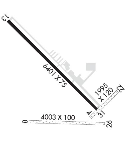
| Lat: N 4428.9 Long: W 10347.2 Elev: 3933 Var: -11 Longest Runway: 6401 | ||
| AWOS: 118.32 CTAF: 122.7 | ||
| |||||||||||||||||||||||||||||||||||||||||||||||||||||||||||||||||||||
| |||||||||||||||||||||||||||||||||||||||||||||||||||||||||||||||||||||
| |||||||||||||||||||||||||||||||||||||||||||||||||||||||||||||||||||||
| Rwy | Rwy | |||||||
| 1995x120 | 1995' | 1995x120 | 1995' | |||||
| 4003x100 | 4003' | 4003x100 | 4003' | |||||
| 6401x75 | 6401' | 6401x75 | 6401' | |||||
| Runway ID | Single Wheel | Double Wheel | Double Tandem Wheel | Dual Double Wheel |
| 04/22 | N/A | N/A | N/A | N/A |
| 08/26 | N/A | N/A | N/A | N/A |
| 13/31 | 33,000 | 45,000 | N/A | N/A |
| These numbers are Advisory and are not limits. The Airport Manager should have more accurate Weight Limits | ||||
 Airport Diagram might not be current. | |
| Facility Name: | BLACK HILLS-CLYDE ICE FLD |
| City Name: | SPEARFISH |
| County: | LAWRENCE |
| State abbrev: | SD |
| State Name: | SOUTH DAKOTA |
| Ownership: | PUBLICLY OWNED |
| Use: | OPEN TO THE PUBLIC |
| Owner's Name: | CITY OF SPEARFISH |
| Address: | 625 NORTH FIFTH STREET |
| SPEARFISH, SD 57783 | |
| Owner's Phone: | 605-642-1333 |
| Manager's Name: | RAY JILEK |
| Address: | 300 AVIATION PLACE |
| SPEARFISH, SD 57783 | |
| Phone: | 605-642-4112 |
| FAA Region: | GREAT LAKES |
| FAA Field Office: | DMA |
| Date | Sunrise | Sunset |
|---|---|---|
| 09/24/21 Friday | 6:44 | 18:49 |
| 09/25/21 Saturday | 6:46 | 18:47 |
| 09/26/21 Sunday | 6:47 | 18:45 |
| 09/27/21 Monday | 6:48 | 18:44 |
| 09/28/21 Tuesday | 6:49 | 18:42 |
| 09/29/21 Wednesday | 6:50 | 18:40 |
| 09/30/21 Thursday | 6:52 | 18:38 |
| 10/01/21 Friday | 6:53 | 18:36 |
| 10/02/21 Saturday | 6:54 | 18:34 |
| 10/03/21 Sunday | 6:55 | 18:32 |
| 10/04/21 Monday | 6:56 | 18:31 |
| 10/05/21 Tuesday | 6:58 | 18:29 |
| 10/06/21 Wednesday | 6:59 | 18:27 |
| 10/07/21 Thursday | 7:00 | 18:25 |
| Airport Attendance Schedule | 7 Days A Week 0730-DUSK; FOR ATTENDANT AFT HRS CALL 605-642-2656/641-2787. |
| Airport Status | OPERATIONAL (This Status can change at any time - please check NOTAMS) |
| Airport Lighting Schedule | ACTVT MIRL RY 13/31; PAPI RYS 13 & 31 AND TWY A LGTS- CTAF. |
| Airport Storage Available | Tie Downs, Hanger |
| Extra Services Available | Air Freight, Crop Dusting, Air Ambulance, Cargo Handling, Charter, Glider, Flight Instruction, Aircraft Rental, Aircraft Sales, Annual Surveying |
| Wind Indicator | YES - (lighted) |
| Control Tower | NO |
| CTAF Frequency | 122.700 |
| Unicom Frequency | 122.700 |
| Rotating Beacon Color | CLEAR-GREEN (Light Land Airport) |
| Segmented Circle | YES |
| Landing Fee | NO |
| Airport Inspected | STATE - performed by STATE AERONAUTICAL PERSONNEL |
| Inspection Date | 09/22/2020 |
| Type of Fuel Available | Grade 100LL, JET A (freeze point -40C) |
| Airframe Repair Service | MAJOR |
| Power Plant Repair Service | MAJOR |
| Latitude | N4428.9 |
| Longitude | W10347.2 (ESTIMATED) |
| Arpt Elevation | 3933ft (SURVEYED) |
| Magnetic Variation | 11E |
| 3 miles E | of SPEARFISH |
| Traffic Pattern Altitude | |
| Sectional Chart | CHEYENNE |
| Operations (Reported) | Yearly | Avg. Daily |
|---|---|---|
| General Aviation Transient | 3600 | 10 |
| General Aviation Local | 10000 | 27 |
| Air Taxi | 180 | 0 |
| Commerical | 0 | 0 |
| Commuter | 0 | 0 |
| Military | 80 | 0 |
| Aircraft based on Field | |
|---|---|
| General Aviation Singles | 68 |
| General Aviation Multi | 4 |
| Jet Aircraft | 0 |
| General Aviation Helicopters | 2 |
| Military Aircraft | 0 |
| Gliders | 1 |
| Ultralights | 0 |
| FSS on field | NO |
| FSS tie-in | HURON |
| FSS Phone | 1-800-WX-BRIEF |
| Who issues Notams | SPF |
| Notam D service at airport | YES |
| ARTCC Name | DENVER |
| Airport Certification | |
| Aircraft Rescue & Firefighting Index | None |
| Airport of Entry | No |
| Custom Landing Rights | No |
| Joint Civil/Military | No |
| Military Landing rights | YES |
| NATIONAL PLAN OF INTEGRATED AIRPORT SYSTEMS (NPIAS) |
| GRANT AGREEMENTS UNDER FAAP/ADAP/AIP |
| ASSURANCES PURSUANT TO TITLE VI, CIVIL RIGHTS ACT OF 1964 |
| HIGH VOL OF ACFT OPRNG INVOF OF MT RUSHMORE AND CRAZY HORSE MONUMENTS AT OR BLW 7500 FT; PILOTS ARE ADVISED TO MNT 122.85 FOR TFC ADVISORIES. |
| IREG OPNS IN & OUT OF PVT AIRFIELD LOCATED APRXLY 3300 FT S OF ARPT; CHECK CTAF FREQ FOR STATUS. |
| RY 22 +4 FT FENCE 50 FT R 141 FT FM THLD & 50 FT L 175 FT FM THLD., |
| NO SNOW REMOVAL ON TURF RYS, CFM CONDS WITH AMGR, CALL 605-642-4112/2656. |
| ULTRALIGHT ACTIVITY ON & INVOF ARPT. |
| GCO AVBL ON FREQ 121.725 (4 CLICKS TO ELLSWORTH APPROACH AND 6 CLICKS TO DENVER CENTER) |
| FOR CD CTC ELLSWORTH APCH AT 605-385-6198, WHEN APCH CLSD CTC DENVER ARTCC AT 303-651-4257. |
Airport Communications & Frequencies:
| |||||||||||||||||
| Runway: 04 | Runway: 22 | ||
| Mag heading: | 34° | Mag heading: | 214° |
| Rwy Slope: | -1.85% Down | Rwy Slope: | 1.85% Up |
| Approach: | Approach: | ||
| Pattern: | Left Traffic | Pattern: | Left Traffic |
| Markings: | Markings: | ||
| Marking Condition: | RY 04/22 & RY 08/26 MARKED WITH BLACK & WHITE EDGE MARKERS. | Marking Condition: | |
| Arresting Dev: | Arresting Dev: | ||
| Lat & Long: | N4428.6 W10346.9 | Lat. & Long.: | N4428.9 W10346.5 |
| Elev: | 3903.9 ft. MSL | Elev: | 3866.9 ft. MSL |
| TCH: | TCH: | ||
| Visual Glide Path: | Visual Glide Path: | ||
| Displaced Threshold: | No | Displaced Threshold: | No |
| Touchdown Zone: | YES | Touchdown Zone: | YES |
| Touchdown Elev.: | 3903.9 feet | Touchdown Elev.: | 3903.9 feet |
| Visual Glide Slope: | Visual Glide Slope: | ||
| RVR Equipment: | RVR Equipment: | ||
| RVV Equipment: | NO | RVV Equipment: | NO |
| Approach Lights: | Approach Lights: | ||
| REIL: | NO | REIL: | NO |
| Centerline Lights: | NO | Centerline Lights: | NO |
| Touchdown lights: | NO | Touchdown lights: | NO |
| Runway Category: | Runway with a Visual Approach | Runway Category: | Runway with a Visual Approach |
| Declared Distances: | Declared Distances: | ||
| Obstructions: | ROAD | Obstructions: | FENCE |
| Marked: | NOT Marked/Lighted | Marked: | NOT Marked/Lighted |
| Clearance slope: | 36:1 | Clearance slope: | 50:1 |
| Obstruction height: | 18 feet AGL | Obstruction height: | 1 feet AGL |
| Dist. from runway: | 650 feet | Dist. from runway: | 150 feet |
| Centerline offset: | Centerline offset: | ||
| Comments: | Comments: |
| Runway: 08 | Runway: 26 | ||
| Mag heading: | 81° | Mag heading: | 261° |
| Rwy Slope: | -.78% Down | Rwy Slope: | .78% Up |
| Approach: | Approach: | ||
| Pattern: | Left Traffic | Pattern: | Left Traffic |
| Markings: | Markings: | ||
| Marking Condition: | Marking Condition: | ||
| Arresting Dev: | Arresting Dev: | ||
| Lat & Long: | N4428.6 W10347.6 | Lat. & Long.: | N4428.6 W10346.7 |
| Elev: | 3932.8 ft. MSL | Elev: | 3901.5 ft. MSL |
| TCH: | TCH: | ||
| Visual Glide Path: | Visual Glide Path: | ||
| Displaced Threshold: | No | Displaced Threshold: | No |
| Touchdown Zone: | YES | Touchdown Zone: | YES |
| Touchdown Elev.: | 3933.1 feet | Touchdown Elev.: | 3930.7 feet |
| Visual Glide Slope: | Visual Glide Slope: | ||
| RVR Equipment: | RVR Equipment: | ||
| RVV Equipment: | NO | RVV Equipment: | NO |
| Approach Lights: | Approach Lights: | ||
| REIL: | NO | REIL: | NO |
| Centerline Lights: | NO | Centerline Lights: | NO |
| Touchdown lights: | NO | Touchdown lights: | NO |
| Runway Category: | Runway with a Visual Approach | Runway Category: | Runway with a Visual Approach |
| Declared Distances: | Declared Distances: | ||
| Obstructions: | Unknown | Obstructions: | |
| Marked: | NOT Marked/Lighted | Marked: | |
| Clearance slope: | 50:1 | Clearance slope: | 50:1 |
| Obstruction height: | 0 feet AGL | Obstruction height: | |
| Dist. from runway: | 0 feet | Dist. from runway: | |
| Centerline offset: | Centerline offset: | ||
| Comments: | Comments: |
| Runway: 13 | Runway: 31 | ||
| Mag heading: | 124° | Mag heading: | 304° |
| Rwy Slope: | .17% Up | Rwy Slope: | -.17% Down |
| Approach: | Approach: | ||
| Pattern: | Right Traffic | Pattern: | Left Traffic |
| Markings: | NONPRECISION INSTRUMENT | Markings: | NONPRECISION INSTRUMENT |
| Marking Condition: | FAIR | Marking Condition: | FAIR |
| Arresting Dev: | Arresting Dev: | ||
| Lat & Long: | N4429.4 W10347.8 | Lat. & Long.: | N4428.7 W10346.8 |
| Elev: | 3884.0 ft. MSL | Elev: | 3895.1 ft. MSL |
| TCH: | 50 ft. AGL | TCH: | 50 ft. AGL |
| Visual Glide Path: | 3.00 degrees | Visual Glide Path: | 3.00 degrees |
| Displaced Threshold: | No | Displaced Threshold: | No |
| Touchdown Zone: | YES | Touchdown Zone: | YES |
| Touchdown Elev.: | 3884.0 feet | Touchdown Elev.: | 3895.2 feet |
| Visual Glide Slope: | 4-Light PAPI on LEFT side of Runway | Visual Glide Slope: | 4-Light PAPI on LEFT side of Runway |
| RVR Equipment: | RVR Equipment: | ||
| RVV Equipment: | NO | RVV Equipment: | NO |
| Approach Lights: | Approach Lights: | ||
| REIL: | NO | REIL: | NO |
| Centerline Lights: | NO | Centerline Lights: | NO |
| Touchdown lights: | NO | Touchdown lights: | NO |
| Runway Category: | Runway with a Non-precision Approach | Runway Category: | Runway with a Non-precision Approach |
| Declared Distances: | Declared Distances: | ||
| Obstructions: | HILL | Obstructions: | |
| Marked: | NOT Marked/Lighted | Marked: | |
| Clearance slope: | 20:1 | Clearance slope: | 20:1 |
| Obstruction height: | 98 feet AGL | Obstruction height: | |
| Dist. from runway: | 2160 feet | Dist. from runway: | |
| Centerline offset: | 380 left of centerline | Centerline offset: | |
| Comments: | Comments: |
Thanks for using FltPlan.com
all rights reserved © 1999-2021 by Flight Plan LLC


