
| SARASOTA/BRADENTON INTL SARASOTA/BRADENTON FL |
| |
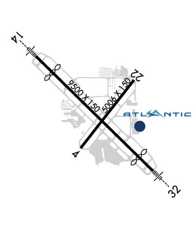
| Lat: N 2723.7 Long: W 08233.3 Elev: 30 Var: +05 Longest Runway: 9500 | ||
| Clr Del: 118.25 Dept. ATIS: 124.37 Arr. ATIS: 124.37 AWOS: 124.37 Ground: 121.9 Tower: 120.1 | ||

| |||||||||||||||||||||||||||||||||||||||||||||||||||||||||||||||||||||
| |||||||||||||||||||||||||||||||||||||||||||||||||||||||||||||||||||||
| |||||||||||||||||||||||||||||||||||||||||||||||||||||||||||||||||||||
| |||||||||||||||||||||||||||||||||||||||||||||||||||||||||||||||||||||
| |||||||||||||||||||||||||||||||||||||||||||||||||||||||||||||||||||||
| |||||||||||||||||||||||||||||||||||||||||||||||||||||||||||||||||||||
| Rwy | Rwy | |||||||
| 5006x150 | 5006' | 5006x150 | 5006' | |||||
| 9500x150 | 8150' | 111.30 - 139° | 9500x150 | 8350' | 109.70 - 319° | |||
| Runway ID | Single Wheel | Double Wheel | Double Tandem Wheel | Dual Double Wheel |
| 04/22 | 120,000 | 219,000 | 404,000 | N/A |
| 14/32 | 118,000 | 196,000 | 358,000 | N/A |
| These numbers are Advisory and are not limits. The Airport Manager should have more accurate Weight Limits | ||||
 Airport Diagram might not be current. | |
| Facility Name: | SARASOTA/BRADENTON INTL |
| City Name: | SARASOTA/BRADENTON |
| County: | SARASOTA; AND MANATEE CO. |
| State abbrev: | FL |
| State Name: | FLORIDA |
| Ownership: | PUBLICLY OWNED |
| Use: | OPEN TO THE PUBLIC |
| Owner's Name: | SARASOTA MANATEE ARPT AUTHORITY |
| Address: | 6000 AIRPORT CIRCLE |
| SARASOTA, FL 34243-2105 | |
| Owner's Phone: | (941) 359-2770 |
| Manager's Name: | FREDERICK J. PICCOLO |
| Address: | 6000 AIRPORT CIRCLE |
| SARASOTA, FL 34243-2105 | |
| Phone: | 941-359-5200 |
| FAA Region: | SOUTHERN |
| FAA Field Office: | ORL |
| Date | Sunrise | Sunset |
|---|---|---|
| 09/24/21 Friday | 7:19 | 19:25 |
| 09/25/21 Saturday | 7:20 | 19:23 |
| 09/26/21 Sunday | 7:20 | 19:22 |
| 09/27/21 Monday | 7:21 | 19:21 |
| 09/28/21 Tuesday | 7:21 | 19:20 |
| 09/29/21 Wednesday | 7:22 | 19:19 |
| 09/30/21 Thursday | 7:22 | 19:18 |
| 10/01/21 Friday | 7:23 | 19:17 |
| 10/02/21 Saturday | 7:23 | 19:16 |
| 10/03/21 Sunday | 7:24 | 19:14 |
| 10/04/21 Monday | 7:24 | 19:13 |
| 10/05/21 Tuesday | 7:25 | 19:12 |
| 10/06/21 Wednesday | 7:25 | 19:11 |
| 10/07/21 Thursday | 7:26 | 19:10 |
| Airport Attendance Schedule | CONTINUOUS |
| Airport Status | OPERATIONAL (This Status can change at any time - please check NOTAMS) |
| Airport Lighting Schedule | WHEN ATCT CLSD ACTVT MALSR RWY 14 & 32; REIL RWY 22; PAPI RWY 04, 22, 14 & 32; HIRL RWY 04/22 & 14/32 - CTAF. |
| Airport Storage Available | Tie Downs, Hanger |
| Extra Services Available | Avionics, Charter, Flight Instruction, Aircraft Rental, Aircraft Sales |
| Wind Indicator | YES - (lighted) |
| Control Tower | YES |
| CTAF Frequency | 120.100 |
| Unicom Frequency | 122.950 |
| Rotating Beacon Color | CLEAR-GREEN (Light Land Airport) |
| Segmented Circle | NO |
| Landing Fee | NO |
| Airport Inspected | FEDERAL - performed by FAA AIRPORTS FIELD PERSONNEL |
| Inspection Date | 01/24/2019 |
| Type of Fuel Available | Grade 100LL, JET A (freeze point -40C), JET A; -10FOR FUEL AVBL CTC FBO. ACR FUEL SVC UNAVBL AFT LAST SKED DEP. 24 HR 100LL SELF SVC FUEL AVBL AT NORTH FBO. |
| Airframe Repair Service | MAJOR |
| Power Plant Repair Service | MAJOR |
| Latitude | N2723.7 |
| Longitude | W08233.3 (ESTIMATED) |
| Arpt Elevation | 29ft (SURVEYED) |
| Magnetic Variation | 05W |
| 3 miles N | of SARASOTA/BRADENTON |
| Traffic Pattern Altitude | |
| Sectional Chart | MIAMI |
| Operations (Reported) | Yearly | Avg. Daily |
|---|---|---|
| General Aviation Transient | 58177 | 159 |
| General Aviation Local | 37176 | 102 |
| Air Taxi | 9905 | 27 |
| Commerical | 15927 | 44 |
| Commuter | 0 | 0 |
| Military | 2678 | 7 |
| Aircraft based on Field | |
|---|---|
| General Aviation Singles | 202 |
| General Aviation Multi | 26 |
| Jet Aircraft | 59 |
| General Aviation Helicopters | 10 |
| Military Aircraft | 0 |
| Gliders | 0 |
| Ultralights | 1 |
| FSS on field | NO |
| FSS tie-in | SAINT PETERSBURG |
| FSS Phone | 1-800-WX-BRIEF |
| Who issues Notams | SRQ |
| Notam D service at airport | YES |
| ARTCC Name | MIAMI |
| Airport Certification | AIRPORT RECEIVING SCHEDULED AIR CARRIER SERVICE FROM CARRIERS CERTIFICATED BY THE CIVIL AERONAUTICS BOARD |
| Aircraft Rescue & Firefighting Index | AIRPORT HAS A CERTIFICATE UNDER CFR PART 139 |
| Airport of Entry | No |
| Custom Landing Rights | No; US CUSTOMS USER FEE ARPT. |
| Joint Civil/Military | No |
| Military Landing rights | YES |
| NATIONAL PLAN OF INTEGRATED AIRPORT SYSTEMS (NPIAS) |
| GRANT AGREEMENTS UNDER FAAP/ADAP/AIP |
| SURPLUS PROPERTY AGREEMENT UNDER REGULATION 16-WAA |
| ADVANCE PLANNING AGREEMENT UNDER FAAP |
| ASSURANCES PURSUANT TO TITLE VI, CIVIL RIGHTS ACT OF 1964 |
| AGREEMENT UNDER DLAND OR DCLA HAS EXPIRED. |
| TWY F LTD TO 70000 LBS GWT. |
| FLD CONDS UNMON 0100-0530. |
| NO INTL FLT DVRSNS ACPTD UNLESS EMERG. |
| FOR CD IF UNA TO CTC ON FSS FREQ, CTC TAMPA APCH AT 813-878-2528 OR 813-371-7745. |
| ACFT RUN-UPS PROHIBITED AT TRML GATES. |
| US CUST GA ACFT AT WEST END OF TRML RAMP. |
| STRICT NOISE ABATEMENT PROC IN EFCT FOR DEP JET ACFT. |
| BIRDS ON & INVOF ARPT. |
| MISC: CLASS C ASP EFF 700-0100 ++; OT CLASS G. CLASS E 700 FT AGL & ABV. |
| TRML RAMP IS UNCTLD. DO NOT CALL FOR PUSH/POWER BACK. ADZ GC WHEN READY TO TAXI. |
| WHEN TWR CLSD HOLD AT ILS HOLD PSN SIGNS ABEAM RWY 14 & RWY 32 THR DURG ALL WX CONDS. APCH TO RWY 14 & RWY 32 CSDRD CLEAR WHEN ACFT ARE BYD RWY 14 & RWY 32 THR BASE UPON LDG DRCTN. |
| DIVD ACR ACFT ADZD TO USE TRML RAMP. |
| PPR FOR HIGH SPEED TAXI TEST - ARPT OPS 941-359-2770 EXT 4300. |
Airport Communications & Frequencies:
| |||||||||||||||||||||||||||||||||||||||||||||
| Runway: 04 | Runway: 22 | ||
| Mag heading: | 43° | Mag heading: | 223° |
| Rwy Slope: | .05% Up | Rwy Slope: | -.05% Down |
| Approach: | Approach: | ||
| Pattern: | Left Traffic | Pattern: | Left Traffic |
| Markings: | NONPRECISION INSTRUMENT | Markings: | NONPRECISION INSTRUMENT |
| Marking Condition: | FAIR | Marking Condition: | FAIR |
| Arresting Dev: | Arresting Dev: | ||
| Lat & Long: | N2723.4 W08233.5 | Lat. & Long.: | N2724.0 W08232.9 |
| Elev: | 21.9 ft. MSL | Elev: | 24.2 ft. MSL |
| TCH: | 46 ft. AGL | TCH: | 43 ft. AGL |
| Visual Glide Path: | 3.00 degrees | Visual Glide Path: | 3.00 degrees |
| Displaced Threshold: | No | Displaced Threshold: | No |
| Touchdown Zone: | YES | Touchdown Zone: | YES |
| Touchdown Elev.: | 23.2 feet | Touchdown Elev.: | 24.2 feet |
| Visual Glide Slope: | 4-Light PAPI on LEFT side of Runway | Visual Glide Slope: | 4-Light PAPI on LEFT side of Runway |
| RVR Equipment: | RVR Equipment: | ||
| RVV Equipment: | NO | RVV Equipment: | NO |
| Approach Lights: | Approach Lights: | ||
| REIL: | NO | REIL: | YES |
| Centerline Lights: | NO | Centerline Lights: | NO |
| Touchdown lights: | NO | Touchdown lights: | NO |
| Runway Category: | Runway with a Non-precision Approach having visibility minimums greater than 3/4 mile | Runway Category: | Runway with a Non-precision Approach having visibility minimums greater than 3/4 mile |
| Declared Distances: | TORA:5006' TODA:5006' ASDA:5006' LDA:5006' | Declared Distances: | TORA:5006' TODA:5006' ASDA:5006' LDA:5006' |
| Obstructions: | TREES | Obstructions: | ROAD |
| Marked: | NOT Marked/Lighted | Marked: | NOT Marked/Lighted |
| Clearance slope: | 20:1 | Clearance slope: | 9:1 |
| Obstruction height: | 55 feet AGL | Obstruction height: | 15 feet AGL |
| Dist. from runway: | 1305 feet | Dist. from runway: | 335 feet |
| Centerline offset: | 235 left of centerline | Centerline offset: | 270 feet left of centerline |
| Comments: | Comments: |
| Runway: 14 | Runway: 32 | ||
| Mag heading: | 139° | Mag heading: | 319° |
| Rwy Slope: | .04% Up | Rwy Slope: | -.04% Down |
| Approach: | ILS | Approach: | ILS |
| Pattern: | Left Traffic | Pattern: | Left Traffic |
| Markings: | PRECISION INSTRUMENT | Markings: | PRECISION INSTRUMENT |
| Marking Condition: | FAIR | Marking Condition: | FAIR |
| Arresting Dev: | Arresting Dev: | ||
| Lat & Long: | N2724.3 W08233.9 | Lat. & Long.: | N2723.2 W08232.7 |
| Elev: | 26.2 ft. MSL | Elev: | 29.9 ft. MSL |
| TCH: | 52 ft. AGL | TCH: | 51 ft. AGL |
| Visual Glide Path: | 3.00 degrees | Visual Glide Path: | 3.00 degrees |
| Displaced Threshold: | 1350 feet | Displaced Threshold: | 1150 feet |
| Touchdown Zone: | YES | Touchdown Zone: | YES |
| Touchdown Elev.: | 22.9 feet | Touchdown Elev.: | 26.7 feet |
| Visual Glide Slope: | 4-Light PAPI on LEFT side of Runway | Visual Glide Slope: | 4-Light PAPI on LEFT side of Runway |
| RVR Equipment: | RVR Equipment: | ||
| RVV Equipment: | NO | RVV Equipment: | NO |
| Approach Lights: | MALSR - 1,400 foot medium intensity approach lighting system with runway alignment indicator lights | Approach Lights: | MALSR - 1,400 foot medium intensity approach lighting system with runway alignment indicator lights |
| REIL: | NO | REIL: | NO |
| Centerline Lights: | NO | Centerline Lights: | NO |
| Touchdown lights: | NO | Touchdown lights: | NO |
| Runway Category: | Precision Instrument Runway | Runway Category: | Precision Instrument Runway |
| Declared Distances: | TORA:8350' TODA:9500' ASDA:8890' LDA:7540' | Declared Distances: | TORA:8150' TODA:9500' ASDA:8660' LDA:7510' |
| Obstructions: | BERM | Obstructions: | TREES |
| Marked: | NOT Marked/Lighted | Marked: | NOT Marked/Lighted |
| Clearance slope: | RWY 14 APCH SLP 50:1 TO DTHR. | Clearance slope: | 8:1 |
| Obstruction height: | 20 feet AGL | Obstruction height: | 33 feet AGL |
| Dist. from runway: | 200 feet | Dist. from runway: | 465 feet |
| Centerline offset: | 465 right of centerline | Centerline offset: | 475 feet left of centerline |
| Comments: | BERM 20 FT TALL 200 FT BFR AER RWY 14 465 RIGHT OF CNTRLN. | Comments: |
Thanks for using FltPlan.com
all rights reserved © 1999-2021 by Flight Plan LLC