
| SHELL LAKE MUNI SHELL LAKE WI |
| |
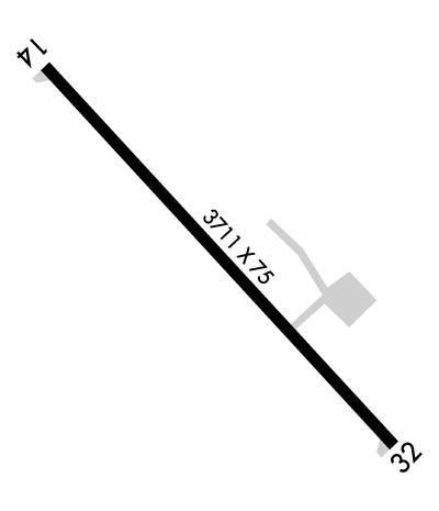
| Lat: N 4543.9 Long: W 09155.2 Elev: 1233 Var: -01 Longest Runway: 3711 | ||
| CTAF: 122.8 | ||
| |||||||||||||||||||||||||||||||||
| |||||||||||||||||||||||||||||||||
| Rwy | Rwy | |||||||
| 3711x75 | 3092' | 3711x75 | 3501' | |||||
| Runway ID | Single Wheel | Double Wheel | Double Tandem Wheel | Dual Double Wheel |
| 14/32 | N/A | N/A | N/A | N/A |
| These numbers are Advisory and are not limits. The Airport Manager should have more accurate Weight Limits | ||||
 Airport Diagram might not be current. | |
| Facility Name: | SHELL LAKE MUNI |
| City Name: | SHELL LAKE |
| County: | WASHBURN |
| State abbrev: | WI |
| State Name: | WISCONSIN |
| Ownership: | PUBLICLY OWNED |
| Use: | OPEN TO THE PUBLIC |
| Owner's Name: | CITY OF SHELL LAKE |
| Address: | CITY HALL, P O BOX 520 |
| SHELL LAKE, WI 54871 | |
| Owner's Phone: | 715-468-7679 |
| Manager's Name: | GERRY WINCH |
| Address: | 41 RIDGEWAY DR, P.O. BOX 520 |
| SHELL LAKE, WI 54871 | |
| Phone: | (715) 296-3638 |
| FAA Region: | GREAT LAKES |
| FAA Field Office: | CHI |
| Date | Sunrise | Sunset |
|---|---|---|
| 03/05/25 Wednesday | 6:40 | 18:00 |
| 03/06/25 Thursday | 6:38 | 18:01 |
| 03/07/25 Friday | 6:36 | 18:03 |
| 03/08/25 Saturday | 6:34 | 18:04 |
| 03/09/25 Sunday | 7:32 | 19:05 |
| 03/10/25 Monday | 7:30 | 19:07 |
| 03/11/25 Tuesday | 7:28 | 19:08 |
| 03/12/25 Wednesday | 7:26 | 19:09 |
| 03/13/25 Thursday | 7:25 | 19:11 |
| 03/14/25 Friday | 7:23 | 19:12 |
| 03/15/25 Saturday | 7:21 | 19:13 |
| 03/16/25 Sunday | 7:19 | 19:15 |
| 03/17/25 Monday | 7:17 | 19:16 |
| 03/18/25 Tuesday | 7:15 | 19:17 |
| Airport Attendance Schedule | UNATTENDED |
| Airport Status | OPERATIONAL (This Status can change at any time - please check NOTAMS) |
| Airport Lighting Schedule | MIRL RWY 14/32 PRESET TO LOW SS-SR; TO INCR INTST AND ACTVT REIL RWY 32; PAPI RWY 14, 32; MIRL RWY 14/32 - CTAF. |
| Airport Storage Available | Tie Downs, Hanger |
| Extra Services Available | Flight Instruction |
| Wind Indicator | YES - (lighted) |
| Control Tower | NO |
| CTAF Frequency | 122.800 |
| Unicom Frequency | 122.800 |
| Rotating Beacon Color | WG |
| Segmented Circle | YES |
| Landing Fee | NO |
| Airport Inspected | STATE - performed by STATE AERONAUTICAL PERSONNEL |
| Inspection Date | 06/20/2024 |
| Type of Fuel Available | None |
| Airframe Repair Service | NONE |
| Power Plant Repair Service | NONE |
| Latitude | N4543.9 |
| Longitude | W09155.2 (ESTIMATED) |
| Arpt Elevation | 1233ft (SURVEYED) |
| Magnetic Variation | 01E |
| 1 miles SE | of SHELL LAKE |
| Traffic Pattern Altitude | |
| Sectional Chart | GREEN BAY |
| Operations (Reported) | Yearly | Avg. Daily |
|---|---|---|
| General Aviation Transient | 0 | 0 |
| General Aviation Local | 0 | 0 |
| Air Taxi | 0 | 0 |
| Commerical | 0 | 0 |
| Commuter | 0 | 0 |
| Military | 0 | 0 |
| Aircraft based on Field | |
|---|---|
| General Aviation Singles | 0 |
| General Aviation Multi | 0 |
| Jet Aircraft | 0 |
| General Aviation Helicopters | 0 |
| Military Aircraft | 0 |
| Gliders | 0 |
| Ultralights | 0 |
| FSS on field | NO |
| FSS tie-in | GREEN BAY |
| FSS Phone | 1-800-WX-BRIEF |
| Who issues Notams | GRB |
| Notam D service at airport | YES |
| ARTCC Name | MINNEAPOLIS |
| Airport Certification | |
| Aircraft Rescue & Firefighting Index | None |
| Airport of Entry | No |
| Custom Landing Rights | No |
| Joint Civil/Military | No |
| Military Landing rights | No |
| NATIONAL PLAN OF INTEGRATED AIRPORT SYSTEMS (NPIAS) |
| (E81) TWY LGTS AT ENTRANCE ONLY. |
| BIRDS ON & INVOF OF ARPT. |
| FOR CD CTC MINNEAPOLIS ARTCC AT 651-463-5588. |
Airport Communications & Frequencies:
| |||||||||
| Runway: 14 | Runway: 32 | ||
| Mag heading: | 136° | Mag heading: | 316° |
| Rwy Slope: | -.10% Down | Rwy Slope: | .10% Up |
| Approach: | Approach: | ||
| Pattern: | Left Traffic | Pattern: | Left Traffic |
| Markings: | NONPRECISION INSTRUMENT | Markings: | NONPRECISION INSTRUMENT |
| Marking Condition: | GOOD | Marking Condition: | GOOD |
| Arresting Dev: | Arresting Dev: | ||
| Lat & Long: | N4544.1 W09155.5 | Lat. & Long.: | N4543.7 W09154.9 |
| Elev: | 1232.0 ft. MSL | Elev: | 1228.3 ft. MSL |
| TCH: | 22 ft. AGL | TCH: | 23 ft. AGL |
| Visual Glide Path: | 4.00 degrees | Visual Glide Path: | 3.00 degrees |
| Displaced Threshold: | 619 feet | Displaced Threshold: | 210 feet |
| Touchdown Zone: | YES | Touchdown Zone: | YES |
| Touchdown Elev.: | 1233.2 feet | Touchdown Elev.: | 1233.3 feet |
| Visual Glide Slope: | 2-Light PAPI on LEFT side of Runway | Visual Glide Slope: | 2-Light PAPI on LEFT side of Runway |
| RVR Equipment: | RVR Equipment: | ||
| RVV Equipment: | NO | RVV Equipment: | NO |
| Approach Lights: | Approach Lights: | ||
| REIL: | NO | REIL: | YES |
| Centerline Lights: | NO | Centerline Lights: | NO |
| Touchdown lights: | NO | Touchdown lights: | NO |
| Runway Category: | Runway with a Non-precision Approach | Runway Category: | Runway with a Non-precision Approach |
| Declared Distances: | TORA:3711' TODA:3711' ASDA:3500' LDA:2881' | Declared Distances: | TORA:3286' TODA:3711' ASDA:3711' LDA:3500' |
| Obstructions: | TREES | Obstructions: | |
| Marked: | LIGHTED | Marked: | |
| Clearance slope: | 9:1; RWY 14 APCH RATIO 18:1 TO DSPLCD THLD; 93 FT TREES 1699 FT 400 L. | Clearance slope: | 20:1 |
| Obstruction height: | 95 feet AGL | Obstruction height: | |
| Dist. from runway: | 1080 feet | Dist. from runway: | |
| Centerline offset: | 400 left of centerline | Centerline offset: | |
| Comments: | Comments: |
Thanks for using FltPlan.com
all rights reserved © 1999-2025 by Flight Plan LLC
