
| TUSCALOOSA NATIONAL AIRPORT TUSCALOOSA AL |
| |
| Lat: N 3313.2 Long: W 08736.7 Elev: 170 Var: -00 Longest Runway: 6499 | ||
| Clr Del: 120.77 AWOS: 132.82 Ground: 121.8 Tower: 126.3 | ||
| ||||||||||||||||||||||||||||||||||||||||||||
| ||||||||||||||||||||||||||||||||||||||||||||
| ||||||||||||||||||||||||||||||||||||||||||||
| ||||||||||||||||||||||||||||||||||||||||||||
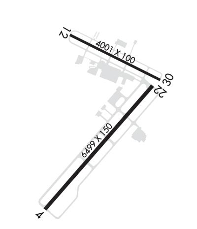
| Rwy | Rwy | |||||||
| 6499x150 | 6499' | 109.10 - 041° | 6499x150 | 6499' | ||||
| 4001x100 | 4001' | 4001x100 | 4001' | |||||
| Runway ID | Single Wheel | Double Wheel | Double Tandem Wheel | Dual Double Wheel |
| 04/22 | 116,000 | 170,000 | 280,000 | 690,000 |
| 12/30 | 15,000 | N/A | N/A | N/A |
| These numbers are Advisory and are not limits. The Airport Manager should have more accurate Weight Limits | ||||
 Airport Diagram might not be current. | |
| Facility Name: | TUSCALOOSA NTL |
| City Name: | TUSCALOOSA |
| County: | TUSCALOOSA |
| State abbrev: | AL |
| State Name: | ALABAMA |
| Ownership: | PUBLICLY OWNED |
| Use: | OPEN TO THE PUBLIC |
| Owner's Name: | CITY OF TUSCALOOSA |
| Address: | 7601 ROBERT CARDINAL AIRPORT ROAD |
| TUSCALOOSA, AL 35401 | |
| Owner's Phone: | (205) 248-5300 |
| Manager's Name: | TOMMY TURNER |
| Address: | 7601 ROBERT CARDINAL ARPT ROAD, STE 208 |
| TUSCALOOSA, AL 35401 | |
| Phone: | 205-454-9939 |
| FAA Region: | SOUTHERN |
| FAA Field Office: | JAN |
| Date | Sunrise | Sunset |
|---|---|---|
| 09/24/21 Friday | 6:40 | 18:45 |
| 09/25/21 Saturday | 6:40 | 18:43 |
| 09/26/21 Sunday | 6:41 | 18:42 |
| 09/27/21 Monday | 6:42 | 18:41 |
| 09/28/21 Tuesday | 6:42 | 18:39 |
| 09/29/21 Wednesday | 6:43 | 18:38 |
| 09/30/21 Thursday | 6:44 | 18:37 |
| 10/01/21 Friday | 6:45 | 18:35 |
| 10/02/21 Saturday | 6:45 | 18:34 |
| 10/03/21 Sunday | 6:46 | 18:33 |
| 10/04/21 Monday | 6:47 | 18:31 |
| 10/05/21 Tuesday | 6:47 | 18:30 |
| 10/06/21 Wednesday | 6:48 | 18:29 |
| 10/07/21 Thursday | 6:49 | 18:27 |
| Airport Attendance Schedule | 7 Days A Week 0500-2200 |
| Airport Status | OPERATIONAL (This Status can change at any time - please check NOTAMS) |
| Airport Lighting Schedule | WHEN ATCT CLSD ACTVT MALSR RWY 04; PAPI RWY 22; HIRL RWY 04/22 MED INTST ONLY; TWY LGTS - CTAF. |
| Airport Storage Available | Tie Downs, Hanger |
| Extra Services Available | Air Freight, Avionics, Cargo Handling, Charter, Flight Instruction, Aircraft Rental, Aircraft Sales |
| Wind Indicator | YES - (lighted) |
| Control Tower | YES |
| CTAF Frequency | 126.300 |
| Unicom Frequency | 122.950 |
| Rotating Beacon Color | CLEAR-GREEN (Light Land Airport) |
| Segmented Circle | YES |
| Landing Fee | NO |
| Airport Inspected | FEDERAL - performed by FAA AIRPORTS FIELD PERSONNEL |
| Inspection Date | 01/30/2020 |
| Type of Fuel Available | Grade 100LL, JET A (freeze point -40C) |
| Airframe Repair Service | MAJOR |
| Power Plant Repair Service | MAJOR |
| Latitude | N3313.2 |
| Longitude | W08736.7 (ESTIMATED) |
| Arpt Elevation | 169ft (SURVEYED) |
| Magnetic Variation | 00E |
| 3 miles NW | of TUSCALOOSA |
| Traffic Pattern Altitude | |
| Sectional Chart | ATLANTA |
| Operations (Reported) | Yearly | Avg. Daily |
|---|---|---|
| General Aviation Transient | 13859 | 38 |
| General Aviation Local | 11476 | 31 |
| Air Taxi | 2604 | 7 |
| Commerical | 153 | 0 |
| Commuter | 0 | 0 |
| Military | 9395 | 26 |
| Aircraft based on Field | |
|---|---|
| General Aviation Singles | 73 |
| General Aviation Multi | 14 |
| Jet Aircraft | 12 |
| General Aviation Helicopters | 6 |
| Military Aircraft | 0 |
| Gliders | 0 |
| Ultralights | 0 |
| FSS on field | NO |
| FSS tie-in | ANNISTON |
| FSS Phone | 1-800-WX-BRIEF |
| Who issues Notams | TCL |
| Notam D service at airport | YES |
| ARTCC Name | ATLANTA |
| Airport Certification | 24 HR PPR RQR FOR UNSKED ACR OPNS GTR THAN 30 PAX SEATS 2130-0500 - CTC AMGR. INDEX B ARFF CAPABILITY AVBL H24. |
| Aircraft Rescue & Firefighting Index | AIRPORT HAS A CERTIFICATE UNDER CFR PART 139 |
| Airport of Entry | No |
| Custom Landing Rights | YES |
| Joint Civil/Military | No |
| Military Landing rights | YES |
| NATIONAL PLAN OF INTEGRATED AIRPORT SYSTEMS (NPIAS) |
| GRANT AGREEMENTS UNDER FAAP/ADAP/AIP |
| ASSURANCES PURSUANT TO TITLE VI, CIVIL RIGHTS ACT OF 1964 |
| THIS AIRPORT HAS BEEN SURVEYED BY THE NATIONAL GEODETIC SURVEY. |
| BIRDS & DEER ON & INVOF ARPT. |
| TWY D CLSD BTN TWY D5 & D6 WHEN TWR CLSD. |
| FOR CD WHEN TWR CLSD, CTC BIRMINGHAM APCH AT 205-769-3890. |
| RWY 12/30 NOT AVBL FOR SKED OPNS WITH MORE THAN 9 PSGR SEATS OR UNSKED ACR AT LEAST 31 PSGR SEATS. |
| RWY 12/3 0 NA WHEN TWR CLSD; LGTD AS A VISUAL RWY. |
Airport Communications & Frequencies:
| ||||||||||||||||||||||||
| Runway: 04 | Runway: 22 | ||
| Mag heading: | 41° | Mag heading: | 221° |
| Rwy Slope: | .17% Up | Rwy Slope: | -.17% Down |
| Approach: | ILS | Approach: | |
| Pattern: | Left Traffic | Pattern: | Left Traffic |
| Markings: | PRECISION INSTRUMENT | Markings: | PRECISION INSTRUMENT |
| Marking Condition: | GOOD | Marking Condition: | GOOD |
| Arresting Dev: | Arresting Dev: | ||
| Lat & Long: | N3312.6 W08737.2 | Lat. & Long.: | N3313.4 W08736.3 |
| Elev: | 153.2 ft. MSL | Elev: | 164.4 ft. MSL |
| TCH: | TCH: | 50 ft. AGL | |
| Visual Glide Path: | Visual Glide Path: | 3.00 degrees | |
| Displaced Threshold: | No | Displaced Threshold: | No |
| Touchdown Zone: | YES | Touchdown Zone: | YES |
| Touchdown Elev.: | 159.5 feet | Touchdown Elev.: | 164.4 feet |
| Visual Glide Slope: | Visual Glide Slope: | 4-Light PAPI on LEFT side of Runway | |
| RVR Equipment: | RVR Equipment: | ||
| RVV Equipment: | NO | RVV Equipment: | NO |
| Approach Lights: | MALSR - 1,400 foot medium intensity approach lighting system with runway alignment indicator lights | Approach Lights: | |
| REIL: | NO | REIL: | NO |
| Centerline Lights: | NO | Centerline Lights: | NO |
| Touchdown lights: | NO | Touchdown lights: | NO |
| Runway Category: | Precision Instrument Runway | Runway Category: | Runway with a Non-precision Approach having visibility minimums greater than 3/4 mile |
| Declared Distances: | Declared Distances: | ||
| Obstructions: | Obstructions: | TREE | |
| Marked: | Marked: | NOT Marked/Lighted | |
| Clearance slope: | 50:1 | Clearance slope: | 35:1 |
| Obstruction height: | Obstruction height: | 38 feet AGL | |
| Dist. from runway: | Dist. from runway: | 1550 feet | |
| Centerline offset: | Centerline offset: | 100 feet left of centerline | |
| Comments: | Comments: |
| Runway: 12 | Runway: 30 | ||
| Mag heading: | 117° | Mag heading: | 297° |
| Rwy Slope: | -.04% Down | Rwy Slope: | .04% Up |
| Approach: | Approach: | ||
| Pattern: | Left Traffic | Pattern: | Left Traffic |
| Markings: | BASIC | Markings: | BASIC |
| Marking Condition: | FAIR | Marking Condition: | FAIR |
| Arresting Dev: | Arresting Dev: | ||
| Lat & Long: | N3313.7 W08737.0 | Lat. & Long.: | N3313.5 W08736.3 |
| Elev: | 166.7 ft. MSL | Elev: | 164.9 ft. MSL |
| TCH: | TCH: | 58 ft. AGL | |
| Visual Glide Path: | Visual Glide Path: | 3.00 degrees | |
| Displaced Threshold: | No | Displaced Threshold: | No |
| Touchdown Zone: | YES | Touchdown Zone: | YES |
| Touchdown Elev.: | 169.9 feet | Touchdown Elev.: | 169.9 feet |
| Visual Glide Slope: | Visual Glide Slope: | 4-Light PAPI on RIGHT side of Runway | |
| RVR Equipment: | RVR Equipment: | ||
| RVV Equipment: | NO | RVV Equipment: | NO |
| Approach Lights: | Approach Lights: | ||
| REIL: | NO | REIL: | NO |
| Centerline Lights: | NO | Centerline Lights: | NO |
| Touchdown lights: | NO | Touchdown lights: | NO |
| Runway Category: | Runway with a Non-precision Approach | Runway Category: | Runway with a Non-precision Approach |
| Declared Distances: | Declared Distances: | ||
| Obstructions: | TREE | Obstructions: | TREES |
| Marked: | NOT Marked/Lighted | Marked: | NOT Marked/Lighted |
| Clearance slope: | 16:1 | Clearance slope: | 25:1 |
| Obstruction height: | 40 feet AGL | Obstruction height: | 61 feet AGL |
| Dist. from runway: | 850 feet | Dist. from runway: | 1725 feet |
| Centerline offset: | 200 right of centerline | Centerline offset: | 180 feet left of centerline |
| Comments: | Comments: |
Thanks for using FltPlan.com
all rights reserved © 1999-2021 by Flight Plan LLC