
| YORK YORK PA |
| |
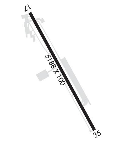
| Lat: N 3955.0 Long: W 07652.4 Elev: 495 Var: +11 Longest Runway: 5188 | ||
| Clr Del: 121.65 AWOS: 119.27 CTAF: 123.0 | ||
| |||||||||||||||||||||||||||||||||||||||||||||
| |||||||||||||||||||||||||||||||||||||||||||||
| |||||||||||||||||||||||||||||||||||||||||||||
| Rwy | Rwy | |||||||
| 5188x100 | 4394' | 5188x100 | 4449' | |||||
| Runway ID | Single Wheel | Double Wheel | Double Tandem Wheel | Dual Double Wheel |
| 17/35 | 20,000 | 20,000 | 20,000 | N/A |
| These numbers are Advisory and are not limits. The Airport Manager should have more accurate Weight Limits | ||||
 Airport Diagram might not be current. | |
| Facility Name: | YORK |
| City Name: | YORK |
| County: | YORK |
| State abbrev: | PA |
| State Name: | PENNSYLVANIA |
| Ownership: | PRIVATELY OWNED |
| Use: | OPEN TO THE PUBLIC |
| Owner's Name: | YORK BLDG PRODUCTS INC |
| Address: | PO BOX 2587 |
| YORK, PA 17405 | |
| Owner's Phone: | 717-792-5566 |
| Manager's Name: | MARK TOMLINSON |
| Address: | 6054 LINCOLN HIGHWAY WEST |
| THOMASVILLE, PA 17364 | |
| Phone: | 717-792-5566 |
| FAA Region: | EASTERN |
| FAA Field Office: | HAR |
| Date | Sunrise | Sunset |
|---|---|---|
| 03/20/25 Thursday | 7:11 | 19:19 |
| 03/21/25 Friday | 7:10 | 19:20 |
| 03/22/25 Saturday | 7:08 | 19:21 |
| 03/23/25 Sunday | 7:07 | 19:22 |
| 03/24/25 Monday | 7:05 | 19:23 |
| 03/25/25 Tuesday | 7:03 | 19:24 |
| 03/26/25 Wednesday | 7:02 | 19:25 |
| 03/27/25 Thursday | 7:00 | 19:26 |
| 03/28/25 Friday | 6:58 | 19:28 |
| 03/29/25 Saturday | 6:57 | 19:29 |
| 03/30/25 Sunday | 6:55 | 19:30 |
| 03/31/25 Monday | 6:54 | 19:31 |
| 04/01/25 Tuesday | 6:52 | 19:32 |
| 04/02/25 Wednesday | 6:50 | 19:33 |
| Airport Attendance Schedule | MON-FRI 0600-1800, SAT-SUN 0800-1700 |
| Airport Status | OPERATIONAL (This Status can change at any time - please check NOTAMS) |
| Airport Lighting Schedule | SS-SR |
| Airport Storage Available | Tie Downs, Hanger |
| Extra Services Available | NONE |
| Wind Indicator | YES - (lighted) |
| Control Tower | NO |
| CTAF Frequency | 123.000 |
| Unicom Frequency | 123.000 |
| Rotating Beacon Color | WG |
| Segmented Circle | NO |
| Landing Fee | YES |
| Airport Inspected | STATE - performed by STATE AERONAUTICAL PERSONNEL |
| Inspection Date | 11/19/2024 |
| Type of Fuel Available | Grade 100LL, JET A (freeze point -40C) |
| Airframe Repair Service | MAJOR |
| Power Plant Repair Service | MAJOR |
| Latitude | N3955.0 |
| Longitude | W07652.4 (ESTIMATED) |
| Arpt Elevation | 494ft (SURVEYED) |
| Magnetic Variation | 11W |
| 7 miles SW | of YORK |
| Traffic Pattern Altitude | |
| Sectional Chart | WASHINGTON |
| Operations (Reported) | Yearly | Avg. Daily |
|---|---|---|
| General Aviation Transient | 0 | 0 |
| General Aviation Local | 0 | 0 |
| Air Taxi | 0 | 0 |
| Commerical | 0 | 0 |
| Commuter | 0 | 0 |
| Military | 0 | 0 |
| Aircraft based on Field | |
|---|---|
| General Aviation Singles | 0 |
| General Aviation Multi | 0 |
| Jet Aircraft | 0 |
| General Aviation Helicopters | 0 |
| Military Aircraft | 0 |
| Gliders | 0 |
| Ultralights | 0 |
| FSS on field | NO |
| FSS tie-in | WILLIAMSPORT |
| FSS Phone | 1-800-WX-BRIEF |
| Who issues Notams | THV |
| Notam D service at airport | YES |
| ARTCC Name | NEW YORK |
| Airport Certification | |
| Aircraft Rescue & Firefighting Index | None |
| Airport of Entry | No |
| Custom Landing Rights | No |
| Joint Civil/Military | No |
| Military Landing rights | YES |
| TREES WI PRIM SFC 83 FT IN FM THLD & 221 FT L OF RWY 17 CNTRLN; RAMP TIE-DOWN AREA, MEDIVAC PARKING PAD & TWY WI PRIM SFC ON R SIDE. |
| TWY TO RWY 35 CLSD TO ACFT WITH WINGSPAN OVER 60 FT. |
| RWY 17 TREES 1383 FT OUT 121 FT RIGHT APCH SLP 21:1 TO DTHR. |
| RWY 35 TREES 2684 FT OUT 425 FT RIGHT APCH SLP 22:1 TO DTHR. |
| FOR CD CTC HARRISBURG APCH AT 800-932-0712. |
Airport Communications & Frequencies:
| ||||||||||||||||
| Runway: 17 | Runway: 35 | ||
| Mag heading: | 166° | Mag heading: | 346° |
| Rwy Slope: | .36% Up | Rwy Slope: | -.36% Down |
| Approach: | Approach: | ||
| Pattern: | Left Traffic | Pattern: | Left Traffic |
| Markings: | NONPRECISION INSTRUMENT | Markings: | NONPRECISION INSTRUMENT |
| Marking Condition: | GOOD | Marking Condition: | GOOD |
| Arresting Dev: | Arresting Dev: | ||
| Lat & Long: | N3955.4 W07652.6 | Lat. & Long.: | N3954.6 W07652.2 |
| Elev: | 475.8 ft. MSL | Elev: | 494.7 ft. MSL |
| TCH: | 20 ft. AGL | TCH: | 28 ft. AGL |
| Visual Glide Path: | 4.50 degrees | Visual Glide Path: | 3.67 degrees |
| Displaced Threshold: | 794 feet | Displaced Threshold: | 739 feet |
| Touchdown Zone: | YES | Touchdown Zone: | YES |
| Touchdown Elev.: | 477.5 feet | Touchdown Elev.: | 484.7 feet |
| Visual Glide Slope: | 4-Light PAPI on LEFT side of Runway | Visual Glide Slope: | 4-Light PAPI on LEFT side of Runway |
| RVR Equipment: | RVR Equipment: | ||
| RVV Equipment: | NO | RVV Equipment: | NO |
| Approach Lights: | Approach Lights: | ||
| REIL: | YES | REIL: | YES |
| Centerline Lights: | NO | Centerline Lights: | NO |
| Touchdown lights: | NO | Touchdown lights: | NO |
| Runway Category: | Runway with a Non-precision Approach having visibility minimums greater than 3/4 mile | Runway Category: | Runway with a Non-precision Approach having visibility minimums greater than 3/4 mile |
| Declared Distances: | Declared Distances: | ||
| Obstructions: | POLE | Obstructions: | TREES |
| Marked: | LIGHTED | Marked: | LIGHTED |
| Clearance slope: | CTLG OBSTN EXCEEDS A 45 DEG SLP. | Clearance slope: | 4:1 |
| Obstruction height: | 40 feet AGL | Obstruction height: | 44 feet AGL |
| Dist. from runway: | 226 feet | Dist. from runway: | 404 feet |
| Centerline offset: | 183 right of centerline | Centerline offset: | 223 feet left of centerline |
| Comments: | RWY 17 HAS +15 FT ROAD 10-200 FT FROM RWY END 250 FT LEFT & RIGHT; +15 BLAST FENCE 50-85 FT FROM RWY END MARKED AND LIGHTED. | Comments: |
Thanks for using FltPlan.com
all rights reserved © 1999-2025 by Flight Plan LLC
