| THOMASVILLE RGNL THOMASVILLE GA |
| |
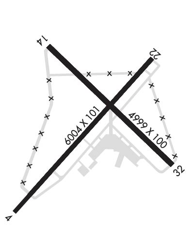
| Lat: N 3054.1 Long: W 08352.9 Elev: 264 Var: +05 Longest Runway: 6004 | ||
| AWOS: 119.17 CTAF: 123.07 | ||
| |||||||||||||||||||||||||||||||||||||||||||||||||||||||||||||
| |||||||||||||||||||||||||||||||||||||||||||||||||||||||||||||
| |||||||||||||||||||||||||||||||||||||||||||||||||||||||||||||
| Rwy | Rwy | |||||||
| 6004x101 | 5498' | 6004x101 | 6004' | 110.10 - 224° | ||||
| 4999x100 | 4999' | 4999x100 | 4999' | |||||
| Runway ID | Single Wheel | Double Wheel | Double Tandem Wheel | Dual Double Wheel |
| 04/22 | 30,000 | N/A | N/A | N/A |
| 14/32 | 20,000 | N/A | N/A | N/A |
| These numbers are Advisory and are not limits. The Airport Manager should have more accurate Weight Limits | ||||
 Airport Diagram might not be current. | |
| Facility Name: | THOMASVILLE RGNL |
| City Name: | THOMASVILLE |
| County: | THOMAS |
| State abbrev: | GA |
| State Name: | GEORGIA |
| Ownership: | PUBLICLY OWNED |
| Use: | OPEN TO THE PUBLIC |
| Owner's Name: | CITY OF THOMASVILLE |
| Address: | PO BOX 1540 |
| THOMASVILLE, GA 31799 | |
| Owner's Phone: | 229-227-3262 |
| Manager's Name: | ROBERT PETTY |
| Address: | 882 AIRPORT RD |
| THOMASVILLE, GA 31757 | |
| Phone: | 229-225-4313 |
| FAA Region: | SOUTHERN |
| FAA Field Office: | ATL |
| Date | Sunrise | Sunset |
|---|---|---|
| 04/27/25 Sunday | 6:55 | 20:11 |
| 04/28/25 Monday | 6:54 | 20:12 |
| 04/29/25 Tuesday | 6:53 | 20:13 |
| 04/30/25 Wednesday | 6:52 | 20:14 |
| 05/01/25 Thursday | 6:52 | 20:14 |
| 05/02/25 Friday | 6:51 | 20:15 |
| 05/03/25 Saturday | 6:50 | 20:16 |
| 05/04/25 Sunday | 6:49 | 20:16 |
| 05/05/25 Monday | 6:48 | 20:17 |
| 05/06/25 Tuesday | 6:47 | 20:18 |
| 05/07/25 Wednesday | 6:46 | 20:18 |
| 05/08/25 Thursday | 6:46 | 20:19 |
| 05/09/25 Friday | 6:45 | 20:20 |
| 05/10/25 Saturday | 6:44 | 20:20 |
| Airport Attendance Schedule | MON-FRI 0600-2000, SAT-SUN 0700-1900 |
| Airport Status | OPERATIONAL (This Status can change at any time - please check NOTAMS) |
| Airport Lighting Schedule | HIRL RWY 04/22 PRESET LOW INTST; TO INCR INTST & ACTVT MALSF - CTAF. ACTVT PAPI RWY 04 & 22 DURG DALGT HRS - CTAF. AFTER DUSK PAPI RWY 04 & 22 OPR CONSLY. |
| Airport Storage Available | Tie Downs, Hanger |
| Extra Services Available | Flight Instruction, Aircraft Rental |
| Wind Indicator | YES - (lighted) |
| Control Tower | NO |
| CTAF Frequency | 123.075 |
| Unicom Frequency | 123.075 |
| Rotating Beacon Color | WG |
| Segmented Circle | NO |
| Landing Fee | NO |
| Airport Inspected | STATE - performed by STATE AERONAUTICAL PERSONNEL |
| Inspection Date | 01/11/2024 |
| Type of Fuel Available | Grade 100LL, JET A (freeze point -40C), JET A |
| Airframe Repair Service | MAJOR |
| Power Plant Repair Service | MAJOR |
| Latitude | N3054.1 |
| Longitude | W08352.9 (ESTIMATED) |
| Arpt Elevation | 263ft (SURVEYED) |
| Magnetic Variation | 05W |
| 6 miles NE | of THOMASVILLE |
| Traffic Pattern Altitude | |
| Sectional Chart | JACKSONVILLE |
| Operations (Reported) | Yearly | Avg. Daily |
|---|---|---|
| General Aviation Transient | 0 | 0 |
| General Aviation Local | 0 | 0 |
| Air Taxi | 0 | 0 |
| Commerical | 0 | 0 |
| Commuter | 0 | 0 |
| Military | 0 | 0 |
| Aircraft based on Field | |
|---|---|
| General Aviation Singles | 0 |
| General Aviation Multi | 0 |
| Jet Aircraft | 0 |
| General Aviation Helicopters | 0 |
| Military Aircraft | 0 |
| Gliders | 0 |
| Ultralights | 0 |
| FSS on field | NO |
| FSS tie-in | MACON |
| FSS Phone | 1-800-WX-BRIEF |
| Who issues Notams | MCN |
| Notam D service at airport | YES |
| ARTCC Name | JACKSONVILLE |
| Airport Certification | |
| Aircraft Rescue & Firefighting Index | None |
| Airport of Entry | No |
| Custom Landing Rights | No |
| Joint Civil/Military | No |
| Military Landing rights | YES |
| NATIONAL PLAN OF INTEGRATED AIRPORT SYSTEMS (NPIAS) |
| GRANT AGREEMENTS UNDER FAAP/ADAP/AIP |
| SURPLUS PROPERTY AGREEMENT UNDER REGULATION 16-WAA |
| ASSURANCES PURSUANT TO TITLE VI, CIVIL RIGHTS ACT OF 1964 |
| AGREEMENT UNDER DLAND OR DCLA HAS EXPIRED. |
| TWYS ON APRON SIDE OF RWYS LGTD. |
Airport Communications & Frequencies:
| |||||||||||||||||||||
| Runway: 04 | Runway: 22 | ||
| Mag heading: | 45° | Mag heading: | 225° |
| Rwy Slope: | -.14% Down | Rwy Slope: | .14% Up |
| Approach: | Approach: | ILS/DME | |
| Pattern: | Left Traffic | Pattern: | Left Traffic |
| Markings: | NONPRECISION INSTRUMENT | Markings: | PRECISION INSTRUMENT |
| Marking Condition: | GOOD | Marking Condition: | GOOD |
| Arresting Dev: | Arresting Dev: | ||
| Lat & Long: | N3053.6 W08353.3 | Lat. & Long.: | N3054.4 W08352.6 |
| Elev: | 238.2 ft. MSL | Elev: | 230.0 ft. MSL |
| TCH: | 54 ft. AGL | TCH: | 61 ft. AGL |
| Visual Glide Path: | 3.00 degrees | Visual Glide Path: | 3.00 degrees |
| Displaced Threshold: | 506 feet | Displaced Threshold: | No |
| Touchdown Zone: | YES | Touchdown Zone: | YES |
| Touchdown Elev.: | 241.7 feet | Touchdown Elev.: | 241.6 feet |
| Visual Glide Slope: | 2-Light PAPI on LEFT side of Runway | Visual Glide Slope: | 2-Light PAPI on LEFT side of Runway |
| RVR Equipment: | RVR Equipment: | ||
| RVV Equipment: | NO | RVV Equipment: | NO |
| Approach Lights: | Approach Lights: | MALSF - 1,400 foot medium intensity approach lighting system with sequenced flashers | |
| REIL: | NO | REIL: | NO |
| Centerline Lights: | NO | Centerline Lights: | NO |
| Touchdown lights: | NO | Touchdown lights: | NO |
| Runway Category: | Runway with a Non-precision Approach having visibility minimums greater than 3/4 mile | Runway Category: | Precision Instrument Runway |
| Declared Distances: | TORA:6004' TODA:6004' ASDA:6004' LDA:5498' | Declared Distances: | TORA:6004' TODA:6004' ASDA:5504' LDA:5504' |
| Obstructions: | Obstructions: | TREES | |
| Marked: | Marked: | NOT Marked/Lighted | |
| Clearance slope: | 34:1; OBST CLNC SLOPE 20:1 TO DTHR. | Clearance slope: | 19:1 |
| Obstruction height: | Obstruction height: | 114 feet AGL | |
| Dist. from runway: | Dist. from runway: | 2366 feet | |
| Centerline offset: | Centerline offset: | 778 feet left of centerline | |
| Comments: | Comments: |
| Runway: 14 | Runway: 32 | ||
| Mag heading: | 138° | Mag heading: | 318° |
| Rwy Slope: | -.28% Down | Rwy Slope: | .28% Up |
| Approach: | Approach: | ||
| Pattern: | Left Traffic | Pattern: | Left Traffic |
| Markings: | NONPRECISION INSTRUMENT | Markings: | NONPRECISION INSTRUMENT |
| Marking Condition: | GOOD | Marking Condition: | GOOD |
| Arresting Dev: | Arresting Dev: | ||
| Lat & Long: | N3054.4 W08353.2 | Lat. & Long.: | N3053.9 W08352.5 |
| Elev: | 263.6 ft. MSL | Elev: | 249.6 ft. MSL |
| TCH: | TCH: | ||
| Visual Glide Path: | Visual Glide Path: | ||
| Displaced Threshold: | No | Displaced Threshold: | No |
| Touchdown Zone: | YES | Touchdown Zone: | YES |
| Touchdown Elev.: | 263.6 feet | Touchdown Elev.: | 249.6 feet |
| Visual Glide Slope: | Visual Glide Slope: | ||
| RVR Equipment: | RVR Equipment: | ||
| RVV Equipment: | NO | RVV Equipment: | NO |
| Approach Lights: | Approach Lights: | ||
| REIL: | NO | REIL: | NO |
| Centerline Lights: | NO | Centerline Lights: | NO |
| Touchdown lights: | NO | Touchdown lights: | NO |
| Runway Category: | Runway with a Visual Approach | Runway Category: | Runway with a Visual Approach |
| Declared Distances: | Declared Distances: | ||
| Obstructions: | TREES | Obstructions: | |
| Marked: | NOT Marked/Lighted | Marked: | |
| Clearance slope: | 15:1 | Clearance slope: | 20:1 |
| Obstruction height: | 72 feet AGL | Obstruction height: | |
| Dist. from runway: | 1280 feet | Dist. from runway: | |
| Centerline offset: | 253 right of centerline | Centerline offset: | |
| Comments: | Comments: |
Thanks for using FltPlan.com
all rights reserved © 1999-2025 by Flight Plan LLC