
| RICHARD B HELGESON TWO HARBORS MN |
| |
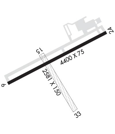
| Lat: N 4702.9 Long: W 09144.7 Elev: 1073 Var: -01 Longest Runway: 4400 | ||
| AWOS: 119.32 CTAF: 122.9 | ||
| ||||||
| ||||||
|
| Rwy | Rwy | |||||||
| 4400x75 | 4400' | 4400x75 | 4400' | |||||
| 2581x150 | 2581' | 2581x150 | 2581' | |||||
| Runway ID | Single Wheel | Double Wheel | Double Tandem Wheel | Dual Double Wheel |
| 06/24 | N/A | N/A | N/A | N/A |
| 15/33 | N/A | N/A | N/A | N/A |
| These numbers are Advisory and are not limits. The Airport Manager should have more accurate Weight Limits | ||||
 Airport Diagram might not be current. | |
| Facility Name: | RICHARD B HELGESON |
| City Name: | TWO HARBORS |
| County: | LAKE |
| State abbrev: | MN |
| State Name: | MINNESOTA |
| Ownership: | PUBLICLY OWNED |
| Use: | OPEN TO THE PUBLIC |
| Owner's Name: | CITY OF TWO HARBORS |
| Address: | CITY HALL, 522 FIRST AVE. |
| TWO HARBORS, MN 55616 | |
| Owner's Phone: | 218-834-5631 |
| Manager's Name: | CASEY KOMAREK |
| Address: | 522 FIRST AVE |
| TWO HARBORS, MN 55616 | |
| Phone: | 218-510-0628 |
| FAA Region: | GREAT LAKES |
| FAA Field Office: | DMA |
| Date | Sunrise | Sunset |
|---|---|---|
| 09/24/21 Friday | 6:56 | 19:01 |
| 09/25/21 Saturday | 6:57 | 18:59 |
| 09/26/21 Sunday | 6:59 | 18:57 |
| 09/27/21 Monday | 7:00 | 18:55 |
| 09/28/21 Tuesday | 7:01 | 18:53 |
| 09/29/21 Wednesday | 7:03 | 18:51 |
| 09/30/21 Thursday | 7:04 | 18:49 |
| 10/01/21 Friday | 7:05 | 18:47 |
| 10/02/21 Saturday | 7:07 | 18:45 |
| 10/03/21 Sunday | 7:08 | 18:43 |
| 10/04/21 Monday | 7:10 | 18:41 |
| 10/05/21 Tuesday | 7:11 | 18:39 |
| 10/06/21 Wednesday | 7:12 | 18:37 |
| 10/07/21 Thursday | 7:14 | 18:35 |
| Airport Attendance Schedule | NOV-APR MON-FRI 0800-1700, MAY-OCT SUN-SAT 0800-1700; FOR SVC AFT HRS CALL (218) 830-0470 |
| Airport Status | OPERATIONAL (This Status can change at any time - please check NOTAMS) |
| Airport Lighting Schedule | MIRL RWY 6/24 PRESET TO LOW SS-SR. INCR INTST AND ACTVT REIL RWY 06, 24; PAPI RWY 6, 24 - CTAF. |
| Airport Storage Available | Tie Downs, Hanger |
| Extra Services Available | NONE |
| Wind Indicator | YES - (lighted) |
| Control Tower | NO |
| CTAF Frequency | 122.900 |
| Unicom Frequency | |
| Rotating Beacon Color | CLEAR-GREEN (Light Land Airport) |
| Segmented Circle | YES |
| Landing Fee | NO |
| Airport Inspected | STATE - performed by STATE AERONAUTICAL PERSONNEL |
| Inspection Date | 06/18/2018 |
| Type of Fuel Available | Grade 100LL, JET A (freeze point -40C)MOGAS; -10FUEL AVBL 24 HRS WITH CREDIT CARD. |
| Airframe Repair Service | MAJOR |
| Power Plant Repair Service | MINOR |
| Latitude | N4702.9 |
| Longitude | W09144.7 (ESTIMATED) |
| Arpt Elevation | 1073ft (SURVEYED) |
| Magnetic Variation | 01E |
| 4 miles NW | of TWO HARBORS |
| Traffic Pattern Altitude | |
| Sectional Chart | GREEN BAY |
| Operations (Reported) | Yearly | Avg. Daily |
|---|---|---|
| General Aviation Transient | 3500 | 10 |
| General Aviation Local | 3500 | 10 |
| Air Taxi | 0 | 0 |
| Commerical | 0 | 0 |
| Commuter | 0 | 0 |
| Military | 0 | 0 |
| Aircraft based on Field | |
|---|---|
| General Aviation Singles | 29 |
| General Aviation Multi | 1 |
| Jet Aircraft | 0 |
| General Aviation Helicopters | 0 |
| Military Aircraft | 0 |
| Gliders | 0 |
| Ultralights | 0 |
| FSS on field | NO |
| FSS tie-in | PRINCETON |
| FSS Phone | 1-800-WX-BRIEF |
| Who issues Notams | TWM |
| Notam D service at airport | YES |
| ARTCC Name | MINNEAPOLIS |
| Airport Certification | |
| Aircraft Rescue & Firefighting Index | None |
| Airport of Entry | No |
| Custom Landing Rights | No |
| Joint Civil/Military | No |
| Military Landing rights | YES |
| NATIONAL PLAN OF INTEGRATED AIRPORT SYSTEMS (NPIAS) |
| GRANT AGREEMENTS UNDER FAAP/ADAP/AIP |
| ASSURANCES PURSUANT TO TITLE VI, CIVIL RIGHTS ACT OF 1964 |
| GCO AVBL ON FREQ 121.725 THRU DLH CD & FLT SVCS. |
| FOR CD CTC DULUTH APCH AT 218-740-5950. |
| RWY 15/3 3 CLSD WINTER MONTHS EXCEPT SKI EQUIPPED ACFT. |
Airport Communications & Frequencies:
| ||||||||||||
| Runway: 06 | Runway: 24 | ||
| Mag heading: | 61° | Mag heading: | 241° |
| Rwy Slope: | -.07% Down | Rwy Slope: | .07% Up |
| Approach: | Approach: | ||
| Pattern: | Left Traffic | Pattern: | Left Traffic |
| Markings: | NONPRECISION INSTRUMENT | Markings: | NONPRECISION INSTRUMENT |
| Marking Condition: | FAIR | Marking Condition: | FAIR |
| Arresting Dev: | Arresting Dev: | ||
| Lat & Long: | N4702.8 W09145.2 | Lat. & Long.: | N4703.2 W09144.2 |
| Elev: | 1073.1 ft. MSL | Elev: | 1070.0 ft. MSL |
| TCH: | 24 ft. AGL | TCH: | 27 ft. AGL |
| Visual Glide Path: | 3.00 degrees | Visual Glide Path: | 3.00 degrees |
| Displaced Threshold: | No | Displaced Threshold: | No |
| Touchdown Zone: | YES | Touchdown Zone: | YES |
| Touchdown Elev.: | 1073.1 feet | Touchdown Elev.: | 1072.8 feet |
| Visual Glide Slope: | 4-Light PAPI on LEFT side of Runway | Visual Glide Slope: | 4-Light PAPI on LEFT side of Runway |
| RVR Equipment: | RVR Equipment: | ||
| RVV Equipment: | NO | RVV Equipment: | NO |
| Approach Lights: | Approach Lights: | ||
| REIL: | YES | REIL: | YES |
| Centerline Lights: | NO | Centerline Lights: | NO |
| Touchdown lights: | NO | Touchdown lights: | NO |
| Runway Category: | Runway with a Non-precision Approach | Runway Category: | Runway with a Non-precision Approach |
| Declared Distances: | Declared Distances: | ||
| Obstructions: | Obstructions: | Unknown | |
| Marked: | Marked: | NOT Marked/Lighted | |
| Clearance slope: | 20:1 | Clearance slope: | 11:1 |
| Obstruction height: | Obstruction height: | 38 feet AGL | |
| Dist. from runway: | Dist. from runway: | 648 feet | |
| Centerline offset: | Centerline offset: | 267 | |
| Comments: | Comments: |
| Runway: 15 | Runway: 33 | ||
| Mag heading: | 147° | Mag heading: | 327° |
| Rwy Slope: | -1.25% Down | Rwy Slope: | 1.25% Up |
| Approach: | Approach: | ||
| Pattern: | Left Traffic | Pattern: | Left Traffic |
| Markings: | Markings: | ||
| Marking Condition: | RY 15/33 MKD WITH YELLOW CONES. | Marking Condition: | |
| Arresting Dev: | Arresting Dev: | ||
| Lat & Long: | N4703.0 W09144.9 | Lat. & Long.: | N4702.7 W09144.5 |
| Elev: | 1072.3 ft. MSL | Elev: | 1040.0 ft. MSL |
| TCH: | TCH: | ||
| Visual Glide Path: | Visual Glide Path: | ||
| Displaced Threshold: | No | Displaced Threshold: | No |
| Touchdown Zone: | YES | Touchdown Zone: | YES |
| Touchdown Elev.: | 1072.3 feet | Touchdown Elev.: | 1072.3 feet |
| Visual Glide Slope: | Visual Glide Slope: | ||
| RVR Equipment: | RVR Equipment: | ||
| RVV Equipment: | NO | RVV Equipment: | NO |
| Approach Lights: | Approach Lights: | ||
| REIL: | NO | REIL: | NO |
| Centerline Lights: | NO | Centerline Lights: | NO |
| Touchdown lights: | NO | Touchdown lights: | NO |
| Runway Category: | Runway with a Visual Approach | Runway Category: | Runway with a Visual Approach |
| Declared Distances: | Declared Distances: | ||
| Obstructions: | TREES | Obstructions: | |
| Marked: | NOT Marked/Lighted | Marked: | |
| Clearance slope: | 20:1 | Clearance slope: | |
| Obstruction height: | 82 feet AGL | Obstruction height: | |
| Dist. from runway: | 1309 feet | Dist. from runway: | |
| Centerline offset: | 97 right of centerline | Centerline offset: | |
| Comments: | Comments: |
Thanks for using FltPlan.com
all rights reserved © 1999-2021 by Flight Plan LLC
