
| AURORA STATE AURORA OR |
| |
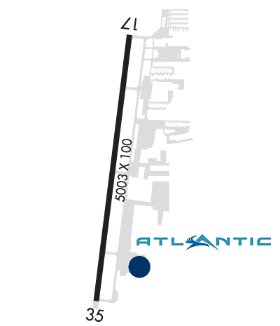
| Lat: N 4514.8 Long: W 12246.2 Elev: 200 Var: -15 Longest Runway: 5003 | ||
| Clr Del: 119.15/119.95 Dept. ATIS: 118.52 Arr. ATIS: 118.52 AWOS: 118.52 Ground: 119.15 Tower: 120.35 | ||

| ||||||||||||||||||||||||||||||||||||||||||||||||||||||||||||||||||||
| ||||||||||||||||||||||||||||||||||||||||||||||||||||||||||||||||||||
| ||||||||||||||||||||||||||||||||||||||||||||||||||||||||||||||||||||
| ||||||||||||||||||||||||||||||||||||||||||||||||||||||||||||||||||||
| Rwy | Rwy | |||||||
| 5003x100 | 5003' | 111.15 - 172° | 5003x100 | 5003' | ||||
| Runway ID | Single Wheel | Double Wheel | Double Tandem Wheel | Dual Double Wheel |
| 17/35 | 30,000 | 45,000 | N/A | N/A |
| These numbers are Advisory and are not limits. The Airport Manager should have more accurate Weight Limits | ||||
 Airport Diagram might not be current. | |
| Facility Name: | AURORA STATE |
| City Name: | AURORA |
| County: | MARION |
| State abbrev: | OR |
| State Name: | OREGON |
| Ownership: | PUBLICLY OWNED |
| Use: | OPEN TO THE PUBLIC |
| Owner's Name: | OREGON DEPT OF AVIATION |
| Address: | 3040 25TH ST SE |
| SALEM, OR 97302-1125 | |
| Owner's Phone: | 503-378-4880 |
| Manager's Name: | ANTHONY BEACH; ANTHONY.BEACH@ODAV.OREGON.GOV |
| Address: | 3040 25TH ST SE |
| SALEM, OR 97302-1125 | |
| Phone: | 503-378-4880 |
| FAA Region: | NORTHWEST MOUNTAIN |
| FAA Field Office: | SEA |
| Date | Sunrise | Sunset |
|---|---|---|
| 03/30/25 Sunday | 6:56 | 19:36 |
| 03/31/25 Monday | 6:54 | 19:38 |
| 04/01/25 Tuesday | 6:52 | 19:39 |
| 04/02/25 Wednesday | 6:50 | 19:40 |
| 04/03/25 Thursday | 6:48 | 19:42 |
| 04/04/25 Friday | 6:46 | 19:43 |
| 04/05/25 Saturday | 6:44 | 19:44 |
| 04/06/25 Sunday | 6:43 | 19:45 |
| 04/07/25 Monday | 6:41 | 19:47 |
| 04/08/25 Tuesday | 6:39 | 19:48 |
| 04/09/25 Wednesday | 6:37 | 19:49 |
| 04/10/25 Thursday | 6:35 | 19:50 |
| 04/11/25 Friday | 6:33 | 19:52 |
| 04/12/25 Saturday | 6:32 | 19:53 |
| Airport Attendance Schedule | 7 Days A Week 0700-2000 |
| Airport Status | OPERATIONAL (This Status can change at any time - please check NOTAMS) |
| Airport Lighting Schedule | ACTVT MIRL RY 17/35, VASI RYS 17 & 35 AND ODALS RY 17 - CTAF. |
| Airport Storage Available | Tie Downs |
| Extra Services Available | Air Ambulance, Avionics, Charter, Flight Instruction, Aircraft Rental, Aircraft Sales |
| Wind Indicator | YES - (lighted) |
| Control Tower | YES |
| CTAF Frequency | 120.350 |
| Unicom Frequency | |
| Rotating Beacon Color | WG |
| Segmented Circle | YES |
| Landing Fee | NO |
| Airport Inspected | STATE - performed by STATE AERONAUTICAL PERSONNEL |
| Inspection Date | 09/12/2024 |
| Type of Fuel Available | Grade 100LL, JET A (freeze point -40C) |
| Airframe Repair Service | MAJOR |
| Power Plant Repair Service | MAJOR |
| Latitude | N4514.8 |
| Longitude | W12246.2 (ESTIMATED) |
| Arpt Elevation | 199ft (SURVEYED) |
| Magnetic Variation | 15E |
| 1 miles NW | of AURORA |
| Traffic Pattern Altitude | |
| Sectional Chart | SEATTLE |
| Operations (Reported) | Yearly | Avg. Daily |
|---|---|---|
| General Aviation Transient | 0 | 0 |
| General Aviation Local | 0 | 0 |
| Air Taxi | 0 | 0 |
| Commerical | 0 | 0 |
| Commuter | 0 | 0 |
| Military | 0 | 0 |
| Aircraft based on Field | |
|---|---|
| General Aviation Singles | 0 |
| General Aviation Multi | 0 |
| Jet Aircraft | 0 |
| General Aviation Helicopters | 0 |
| Military Aircraft | 0 |
| Gliders | 0 |
| Ultralights | 0 |
| FSS on field | NO |
| FSS tie-in | MC MINNVILLE |
| FSS Phone | 1-800-WX-BRIEF |
| Who issues Notams | UAO |
| Notam D service at airport | YES |
| ARTCC Name | SEATTLE |
| Airport Certification | |
| Aircraft Rescue & Firefighting Index | None |
| Airport of Entry | No |
| Custom Landing Rights | No |
| Joint Civil/Military | No |
| Military Landing rights | YES |
| NATIONAL PLAN OF INTEGRATED AIRPORT SYSTEMS (NPIAS) |
| GRANT AGREEMENTS UNDER FAAP/ADAP/AIP |
| ASSURANCES PURSUANT TO TITLE VI, CIVIL RIGHTS ACT OF 1964 |
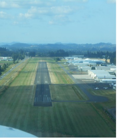
| RY 35 CALM WIND RY. USE ONLY PAVED SFCS. FREQUENT STRAIGHT IN INSTRUMENT APCH TFC TO RY 17. |
| OVERWEIGHT ACFT CTC OWNER PRIOR 503-378-4880 |
| RY 17 +30 FT PLINE 2100 FT FM THLD; MKD BY BALLS. |
| PARALLEL TWY 35 FT WIDE AND HAS MEDIUM INTENSITY TWY LGTS. |
| MIGRATORY BIRDS, COYOTES, AND DEER ON AND INVOF ARPT. |
| NOISE ABATEMENT SENS AREA: 2 MI N OF RWY 17; 1 MI SE OF RWY 35; HLF MI SW OF RWY 35. AVOID LOW LEVEL OVER-FLIGHTS OF RESIDENTIAL AREAS SRNDG ARPT WHENEVER POSS. |
| NOISE ABATEMENT PROC IN EFCT, CTC OPS FOR NOISE RULES 503-931-4298. |
| ALL TAXILANES NON STD WINGTIP CLNC. |
| RWY 17/3 5 RY 17/35 150 FT BLAST PAD AT SOUTH END. |
Airport Communications & Frequencies:
| ||||||||||||||||||||||||||||||
| Runway: 17 | Runway: 35 | ||
| Mag heading: | 172° | Mag heading: | 352° |
| Rwy Slope: | -.06% Down | Rwy Slope: | .06% Up |
| Approach: | LOC/DME | Approach: | |
| Pattern: | Left Traffic | Pattern: | Left Traffic |
| Markings: | PRECISION INSTRUMENT | Markings: | PRECISION INSTRUMENT |
| Marking Condition: | GOOD | Marking Condition: | GOOD |
| Arresting Dev: | Arresting Dev: | ||
| Lat & Long: | N4515.2 W12246.1 | Lat. & Long.: | N4514.4 W12246.3 |
| Elev: | 199.5 ft. MSL | Elev: | 196.3 ft. MSL |
| TCH: | 38 ft. AGL | TCH: | 51 ft. AGL |
| Visual Glide Path: | 3.50 degrees | Visual Glide Path: | 3.25 degrees |
| Displaced Threshold: | No | Displaced Threshold: | No |
| Touchdown Zone: | YES | Touchdown Zone: | YES |
| Touchdown Elev.: | 199.6 feet | Touchdown Elev.: | 198.4 feet |
| Visual Glide Slope: | 4-BOX VASI ON RIGHT SIDE OF RUNWAY | Visual Glide Slope: | 4-BOX VASI ON LEFT SIDE OF RUNWAY |
| RVR Equipment: | RVR Equipment: | ||
| RVV Equipment: | NO | RVV Equipment: | NO |
| Approach Lights: | ODALS - omnidirectional approach lighting system | Approach Lights: | |
| REIL: | NO | REIL: | NO |
| Centerline Lights: | NO | Centerline Lights: | NO |
| Touchdown lights: | NO | Touchdown lights: | NO |
| Runway Category: | Runway with a Non-precision Approach having visibility minimums greater than 3/4 mile | Runway Category: | Runway with a Non-precision Approach having visibility minimums greater than 3/4 mile |
| Declared Distances: | Declared Distances: | ||
| Obstructions: | TREES | Obstructions: | TREE |
| Marked: | NOT Marked/Lighted | Marked: | NOT Marked/Lighted |
| Clearance slope: | 27:1 | Clearance slope: | 16:1 |
| Obstruction height: | 100 feet AGL | Obstruction height: | 90 feet AGL |
| Dist. from runway: | 2939 feet | Dist. from runway: | 1634 feet |
| Centerline offset: | 175 right of centerline | Centerline offset: | 520 feet left of centerline |
| Comments: | Comments: |
Thanks for using FltPlan.com
all rights reserved © 1999-2025 by Flight Plan LLC


