
| HUNTSVILLE MUNI HUNTSVILLE TX |
| |
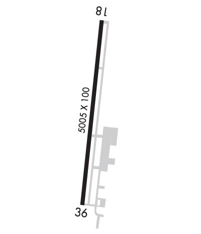
| Lat: N 3044.8 Long: W 09535.2 Elev: 363 Var: -06 Longest Runway: 5005 | ||
| AWOS: 119.42 CTAF: 122.8 | ||
| ||||||
| ||||||
|
| Rwy | Rwy | |||||||
| 5005x100 | 5005' | 5005x100 | 5005' | |||||
| Runway ID | Single Wheel | Double Wheel | Double Tandem Wheel | Dual Double Wheel |
| 18/36 | 27,000 | N/A | N/A | N/A |
| These numbers are Advisory and are not limits. The Airport Manager should have more accurate Weight Limits | ||||
 Airport Diagram might not be current. | |
| Facility Name: | HUNTSVILLE MUNI |
| City Name: | HUNTSVILLE |
| County: | WALKER |
| State abbrev: | TX |
| State Name: | TEXAS |
| Ownership: | PUBLICLY OWNED |
| Use: | OPEN TO THE PUBLIC |
| Owner's Name: | CITY OF HUNTSVILLE |
| Address: | 1212 AVENUE M |
| HUNTSVILLE, TX 77340 | |
| Owner's Phone: | 936-291-5401 |
| Manager's Name: | KEVIN BYAL; DIR OF DVLPMT SVCS |
| Address: | 448 SH 75 NORTH |
| HUNTSVILLE, TX 77340 | |
| Phone: | 936-295-8136; ON SITE ATTENDANT. |
| FAA Region: | SOUTHWEST |
| FAA Field Office: | TEX |
| Date | Sunrise | Sunset |
|---|---|---|
| 02/10/25 Monday | 7:08 | 18:06 |
| 02/11/25 Tuesday | 7:07 | 18:07 |
| 02/12/25 Wednesday | 7:06 | 18:08 |
| 02/13/25 Thursday | 7:05 | 18:09 |
| 02/14/25 Friday | 7:04 | 18:09 |
| 02/15/25 Saturday | 7:03 | 18:10 |
| 02/16/25 Sunday | 7:02 | 18:11 |
| 02/17/25 Monday | 7:01 | 18:12 |
| 02/18/25 Tuesday | 7:01 | 18:13 |
| 02/19/25 Wednesday | 7:00 | 18:13 |
| 02/20/25 Thursday | 6:59 | 18:14 |
| 02/21/25 Friday | 6:58 | 18:15 |
| 02/22/25 Saturday | 6:57 | 18:16 |
| 02/23/25 Sunday | 6:56 | 18:16 |
| Airport Attendance Schedule | 7 Days A Week DAWN-DUSK |
| Airport Status | OPERATIONAL (This Status can change at any time - please check NOTAMS) |
| Airport Lighting Schedule | DUSK-DAWN. MIRL RWY 18/36 PRESET LOW INTST; TO INCR INTST & ACTVT REIL RWYS 18 & 36 - CTAF. |
| Airport Storage Available | Tie Downs, Hanger |
| Extra Services Available | Flight Instruction, Aircraft Rental |
| Wind Indicator | YES - (lighted) |
| Control Tower | NO |
| CTAF Frequency | 122.800 |
| Unicom Frequency | 122.800 |
| Rotating Beacon Color | WG |
| Segmented Circle | YES |
| Landing Fee | NO |
| Airport Inspected | STATE - performed by PRIVATE CONTRACT PERSONNEL |
| Inspection Date | 04/08/2023 |
| Type of Fuel Available | Grade 100LL, JET A (freeze point -40C), JET A |
| Airframe Repair Service | MAJOR |
| Power Plant Repair Service | MAJOR |
| Latitude | N3044.8 |
| Longitude | W09535.2 (ESTIMATED) |
| Arpt Elevation | 362ft (SURVEYED) |
| Magnetic Variation | 06E |
| 2 miles NW | of HUNTSVILLE |
| Traffic Pattern Altitude | |
| Sectional Chart | HOUSTON |
| Operations (Reported) | Yearly | Avg. Daily |
|---|---|---|
| General Aviation Transient | 0 | 0 |
| General Aviation Local | 0 | 0 |
| Air Taxi | 0 | 0 |
| Commerical | 0 | 0 |
| Commuter | 0 | 0 |
| Military | 0 | 0 |
| Aircraft based on Field | |
|---|---|
| General Aviation Singles | 0 |
| General Aviation Multi | 0 |
| Jet Aircraft | 0 |
| General Aviation Helicopters | 0 |
| Military Aircraft | 0 |
| Gliders | 0 |
| Ultralights | 0 |
| FSS on field | NO |
| FSS tie-in | MONTGOMERY COUNTY |
| FSS Phone | 1-800-WX-BRIEF |
| Who issues Notams | UTS |
| Notam D service at airport | YES |
| ARTCC Name | HOUSTON |
| Airport Certification | |
| Aircraft Rescue & Firefighting Index | None |
| Airport of Entry | No |
| Custom Landing Rights | No |
| Joint Civil/Military | No |
| Military Landing rights | YES |
| NATIONAL PLAN OF INTEGRATED AIRPORT SYSTEMS (NPIAS) |
| GRANT AGREEMENTS UNDER FAAP/ADAP/AIP |
| ASSURANCES PURSUANT TO TITLE VI, CIVIL RIGHTS ACT OF 1964 |
| THIS AIRPORT HAS BEEN SURVEYED BY THE NATIONAL GEODETIC SURVEY. |
| FOR CD IF UNA TO CTC ON FSS FREQ, CTC HOUSTON ARTCC AT 281-230-5622. |
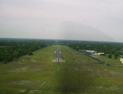
| RWY 18/3 6 PVMT EXTSV CRACKING, SFC SPALLING, VEGETATION GROWING THROUGH. |
Airport Communications & Frequencies:
| |||||||||
| Runway: 18 | Runway: 36 | ||
| Mag heading: | 180° | Mag heading: | 0° |
| Rwy Slope: | 1.26% Up | Rwy Slope: | -1.26% Down |
| Approach: | Approach: | ||
| Pattern: | Left Traffic | Pattern: | Left Traffic |
| Markings: | NONPRECISION INSTRUMENT | Markings: | NONPRECISION INSTRUMENT |
| Marking Condition: | GOOD | Marking Condition: | GOOD |
| Arresting Dev: | Arresting Dev: | ||
| Lat & Long: | N3045.2 W09535.2 | Lat. & Long.: | N3044.4 W09535.3 |
| Elev: | 299.4 ft. MSL | Elev: | 362.3 ft. MSL |
| TCH: | 26 ft. AGL | TCH: | 40 ft. AGL |
| Visual Glide Path: | 3.00 degrees | Visual Glide Path: | 3.00 degrees |
| Displaced Threshold: | No | Displaced Threshold: | No |
| Touchdown Zone: | YES | Touchdown Zone: | YES |
| Touchdown Elev.: | 338.0 feet | Touchdown Elev.: | 362.9 feet |
| Visual Glide Slope: | 4-Light PAPI on LEFT side of Runway | Visual Glide Slope: | 4-Light PAPI on LEFT side of Runway |
| RVR Equipment: | RVR Equipment: | ||
| RVV Equipment: | NO | RVV Equipment: | NO |
| Approach Lights: | Approach Lights: | ||
| REIL: | YES | REIL: | YES |
| Centerline Lights: | NO | Centerline Lights: | NO |
| Touchdown lights: | NO | Touchdown lights: | NO |
| Runway Category: | Runway with a Non-precision Approach having visibility minimums greater than 3/4 mile | Runway Category: | Runway with a Visual Approach |
| Declared Distances: | Declared Distances: | ||
| Obstructions: | TREES | Obstructions: | POLE |
| Marked: | NOT Marked/Lighted | Marked: | NOT Marked/Lighted |
| Clearance slope: | Clearance slope: | 20:1 | |
| Obstruction height: | 30 feet AGL | Obstruction height: | 45 feet AGL |
| Dist. from runway: | 201 feet | Dist. from runway: | 1135 feet |
| Centerline offset: | 175 right of centerline | Centerline offset: | 195 feet right of centerline |
| Comments: | 10-30 FT BRUSH & TREES 0-199 FT DSTC, 175 FT RIGHT. | Comments: |
Thanks for using FltPlan.com
all rights reserved © 1999-2025 by Flight Plan LLC