
| BRIDGEWATER AIR PARK BRIDGEWATER VA |
| |
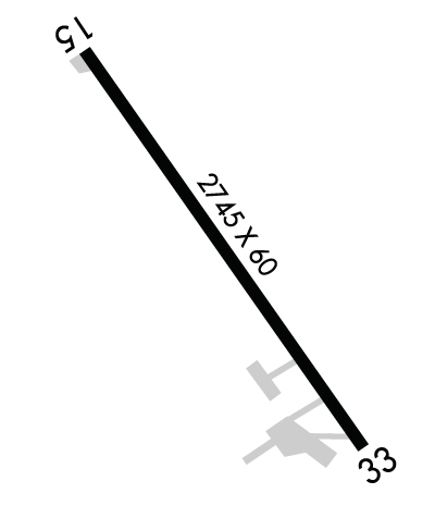
| Lat: N 3821.9 Long: W 07857.5 Elev: 1165 Var: +09 Longest Runway: 4034 | ||
| AWOS: 119.55 CTAF: 122.7 | ||
| ||||||
| ||||||
|
| Rwy | Rwy | |||||||
| 4034x60 | 3889' | 4034x60 | 4034' | |||||
| Runway ID | Single Wheel | Double Wheel | Double Tandem Wheel | Dual Double Wheel |
| 15/33 | 22,000 | N/A | N/A | N/A |
| These numbers are Advisory and are not limits. The Airport Manager should have more accurate Weight Limits | ||||
 Airport Diagram might not be current. | |
| Facility Name: | BRIDGEWATER AIR PARK |
| City Name: | BRIDGEWATER |
| County: | ROCKINGHAM |
| State abbrev: | VA |
| State Name: | VIRGINIA |
| Ownership: | PRIVATELY OWNED |
| Use: | OPEN TO THE PUBLIC |
| Owner's Name: | ROCKINGHAM AVIATION CORP |
| Address: | PO BOX 7 |
| BRIDGEWATER, VA 22812 | |
| Owner's Phone: | 540-828-3214 |
| Manager's Name: | AARON LORSON |
| Address: | PO BOX 7 |
| BRIDGEWATER, VA 22812 | |
| Phone: | 540-828-6070 |
| FAA Region: | EASTERN |
| FAA Field Office: | DCA |
| Date | Sunrise | Sunset |
|---|---|---|
| 04/27/25 Sunday | 6:24 | 20:03 |
| 04/28/25 Monday | 6:23 | 20:04 |
| 04/29/25 Tuesday | 6:22 | 20:05 |
| 04/30/25 Wednesday | 6:21 | 20:06 |
| 05/01/25 Thursday | 6:19 | 20:07 |
| 05/02/25 Friday | 6:18 | 20:08 |
| 05/03/25 Saturday | 6:17 | 20:09 |
| 05/04/25 Sunday | 6:16 | 20:10 |
| 05/05/25 Monday | 6:15 | 20:11 |
| 05/06/25 Tuesday | 6:14 | 20:12 |
| 05/07/25 Wednesday | 6:13 | 20:13 |
| 05/08/25 Thursday | 6:11 | 20:14 |
| 05/09/25 Friday | 6:10 | 20:15 |
| 05/10/25 Saturday | 6:09 | 20:16 |
| Airport Attendance Schedule | MON-FRI 0800-1700, SAT 0900-1600, SUN 1200-1600 |
| Airport Status | OPERATIONAL (This Status can change at any time - please check NOTAMS) |
| Airport Lighting Schedule | ACTVT MIRL RWY 15/33 - CTAF. |
| Airport Storage Available | Tie Downs |
| Extra Services Available | NONE |
| Wind Indicator | YES - (unlit) |
| Control Tower | NO |
| CTAF Frequency | 122.700 |
| Unicom Frequency | 122.700 |
| Rotating Beacon Color | WG |
| Segmented Circle | NO |
| Landing Fee | NO |
| Airport Inspected | STATE - performed by STATE AERONAUTICAL PERSONNEL |
| Inspection Date | 08/31/2022 |
| Type of Fuel Available | JET A |
| Airframe Repair Service | None |
| Power Plant Repair Service | None |
| Latitude | N3821.9 |
| Longitude | W07857.5 (ESTIMATED) |
| Arpt Elevation | 1165ft (ESTIMATED) |
| Magnetic Variation | 09W |
| 1 miles SE | of BRIDGEWATER |
| Traffic Pattern Altitude | |
| Sectional Chart | WASHINGTON |
| Operations (Reported) | Yearly | Avg. Daily |
|---|---|---|
| General Aviation Transient | 0 | 0 |
| General Aviation Local | 0 | 0 |
| Air Taxi | 0 | 0 |
| Commerical | 0 | 0 |
| Commuter | 0 | 0 |
| Military | 0 | 0 |
| Aircraft based on Field | |
|---|---|
| General Aviation Singles | 0 |
| General Aviation Multi | 0 |
| Jet Aircraft | 0 |
| General Aviation Helicopters | 0 |
| Military Aircraft | 0 |
| Gliders | 0 |
| Ultralights | 0 |
| FSS on field | NO |
| FSS tie-in | LEESBURG |
| FSS Phone | 1-800-WX-BRIEF |
| Who issues Notams | DCA |
| Notam D service at airport | YES |
| ARTCC Name | WASHINGTON |
| Airport Certification | |
| Aircraft Rescue & Firefighting Index | None |
| Airport of Entry | No |
| Custom Landing Rights | No |
| Joint Civil/Military | No |
| Military Landing rights | No |
| FOR CD CTC POTOMAC APCH AT 866-640-4124. |
Airport Communications & Frequencies:
| ||||||||||||||
| Runway: 15 | Runway: 33 | ||
| Mag heading: | 152° | Mag heading: | 332° |
| Rwy Slope: | .14% Up | Rwy Slope: | -.14% Down |
| Approach: | Approach: | ||
| Pattern: | Left Traffic | Pattern: | Left Traffic |
| Markings: | NONPRECISION INSTRUMENT | Markings: | NONPRECISION INSTRUMENT |
| Marking Condition: | FAIR | Marking Condition: | FAIR |
| Arresting Dev: | Arresting Dev: | ||
| Lat & Long: | N3822.2 W07857.8 | Lat. & Long.: | N3821.7 W07857.3 |
| Elev: | 1156.8 ft. MSL | Elev: | 1162.6 ft. MSL |
| TCH: | TCH: | ||
| Visual Glide Path: | Visual Glide Path: | ||
| Displaced Threshold: | 145 feet | Displaced Threshold: | No |
| Touchdown Zone: | YES | Touchdown Zone: | YES |
| Touchdown Elev.: | 1157.2 feet | Touchdown Elev.: | 1162.6 feet |
| Visual Glide Slope: | Visual Glide Slope: | ||
| RVR Equipment: | RVR Equipment: | ||
| RVV Equipment: | NO | RVV Equipment: | NO |
| Approach Lights: | Approach Lights: | ||
| REIL: | NO | REIL: | NO |
| Centerline Lights: | NO | Centerline Lights: | NO |
| Touchdown lights: | NO | Touchdown lights: | NO |
| Runway Category: | Runway with a Non-precision Approach having visibility minimums greater than 3/4 mile | Runway Category: | Runway with a Non-precision Approach having visibility minimums greater than 3/4 mile |
| Declared Distances: | Declared Distances: | ||
| Obstructions: | Obstructions: | POLE | |
| Marked: | Marked: | NOT Marked/Lighted | |
| Clearance slope: | 34:1 | Clearance slope: | 30:1 |
| Obstruction height: | Obstruction height: | 19 feet AGL | |
| Dist. from runway: | Dist. from runway: | 781 feet | |
| Centerline offset: | Centerline offset: | 293 feet right of centerline | |
| Comments: | Comments: | +10 FT ROAD 25 FT FM RWY END. ACFT PRKG AND TAXIING WI 200 FT OF THR AND 200 FT OF CNTRLN, LEFT ON APCH. |
Thanks for using FltPlan.com
all rights reserved © 1999-2025 by Flight Plan LLC
