
| MILLER FIELD VALENTINE NE |
| |
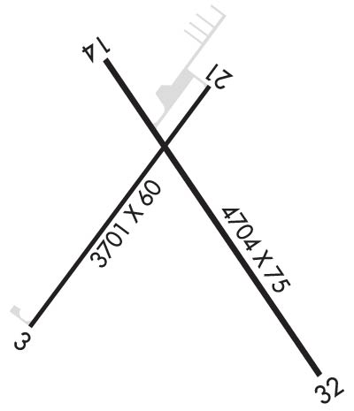
| Lat: N 4251.4 Long: W 10032.9 Elev: 2595 Var: -08 Longest Runway: 4704 | ||
| AWOS: 118.07 CTAF: 122.8 | ||
| ||||||||||||||||||||||||||||||||||||||||||||
| ||||||||||||||||||||||||||||||||||||||||||||
| ||||||||||||||||||||||||||||||||||||||||||||
| Rwy | Rwy | |||||||
| 3701x60 | 3701' | 3701x60 | 3402' | |||||
| 4704x75 | 4320' | 4704x75 | 4704' | |||||
| Runway ID | Single Wheel | Double Wheel | Double Tandem Wheel | Dual Double Wheel |
| 03/21 | 12,500 | N/A | N/A | N/A |
| 14/32 | 30,000 | 42,500 | N/A | N/A |
| These numbers are Advisory and are not limits. The Airport Manager should have more accurate Weight Limits | ||||
 Airport Diagram might not be current. | |
| Facility Name: | MILLER FLD |
| City Name: | VALENTINE |
| County: | CHERRY |
| State abbrev: | NE |
| State Name: | NEBRASKA |
| Ownership: | PUBLICLY OWNED |
| Use: | OPEN TO THE PUBLIC |
| Owner's Name: | CITY OF VALENTINE |
| Address: | P.O. BOX 177, 323 NORTH MAIN |
| VALENTINE, NE 69201-0177 | |
| Owner's Phone: | 402-376-2323; CITY HALL PHONE NUMBER. |
| Manager's Name: | ROBERT KILMER |
| Address: | 100 SOUTH STREET |
| VALENTINE, NE 69201-9501 | |
| Phone: | 402-376-1611 |
| FAA Region: | CENTRAL |
| FAA Field Office: | NONE |
| Date | Sunrise | Sunset |
|---|---|---|
| 09/24/21 Friday | 7:31 | 19:36 |
| 09/25/21 Saturday | 7:33 | 19:34 |
| 09/26/21 Sunday | 7:34 | 19:33 |
| 09/27/21 Monday | 7:35 | 19:31 |
| 09/28/21 Tuesday | 7:36 | 19:29 |
| 09/29/21 Wednesday | 7:37 | 19:27 |
| 09/30/21 Thursday | 7:38 | 19:26 |
| 10/01/21 Friday | 7:39 | 19:24 |
| 10/02/21 Saturday | 7:40 | 19:22 |
| 10/03/21 Sunday | 7:41 | 19:20 |
| 10/04/21 Monday | 7:43 | 19:19 |
| 10/05/21 Tuesday | 7:44 | 19:17 |
| 10/06/21 Wednesday | 7:45 | 19:15 |
| 10/07/21 Thursday | 7:46 | 19:13 |
| Airport Attendance Schedule | MON-FRI 0800-1700, SAT 0900-1600 |
| Airport Status | OPERATIONAL (This Status can change at any time - please check NOTAMS) |
| Airport Lighting Schedule | ACTVT MIRL RYS 03/21 & 14/32, PAPI RYS 03, 21, 14 & 32; REIL RY 32 - CTAF. |
| Airport Storage Available | Tie Downs |
| Extra Services Available | Charter, Flight Instruction, Aircraft Rental |
| Wind Indicator | YES - (lighted) |
| Control Tower | NO |
| CTAF Frequency | 122.800 |
| Unicom Frequency | 122.800 |
| Rotating Beacon Color | CLEAR-GREEN (Light Land Airport) |
| Segmented Circle | YES |
| Landing Fee | NO |
| Airport Inspected | STATE - performed by STATE AERONAUTICAL PERSONNEL |
| Inspection Date | 06/24/2020 |
| Type of Fuel Available | Grade 100LL, JET A (freeze point -40C); -10FUEL AVBL 24 HRS WITH CREDIT CARD OR BY PRIOR ARRANGEMENT CALL (402) 376-2215. |
| Airframe Repair Service | MAJOR |
| Power Plant Repair Service | MAJOR |
| Latitude | N4251.4 |
| Longitude | W10032.9 (ESTIMATED) |
| Arpt Elevation | 2595ft (SURVEYED) |
| Magnetic Variation | 08E |
| 1 miles S | of VALENTINE |
| Traffic Pattern Altitude | |
| Sectional Chart | OMAHA |
| Operations (Reported) | Yearly | Avg. Daily |
|---|---|---|
| General Aviation Transient | 1500 | 4 |
| General Aviation Local | 2450 | 7 |
| Air Taxi | 935 | 3 |
| Commerical | 0 | 0 |
| Commuter | 0 | 0 |
| Military | 15 | 0 |
| Aircraft based on Field | |
|---|---|
| General Aviation Singles | 28 |
| General Aviation Multi | 3 |
| Jet Aircraft | 0 |
| General Aviation Helicopters | 0 |
| Military Aircraft | 0 |
| Gliders | 0 |
| Ultralights | 0 |
| FSS on field | NO |
| FSS tie-in | COLUMBUS |
| FSS Phone | 1-800-WX-BRIEF |
| Who issues Notams | VTN |
| Notam D service at airport | YES |
| ARTCC Name | DENVER |
| Airport Certification | |
| Aircraft Rescue & Firefighting Index | None |
| Airport of Entry | No |
| Custom Landing Rights | No |
| Joint Civil/Military | No |
| Military Landing rights | YES |
| NATIONAL PLAN OF INTEGRATED AIRPORT SYSTEMS (NPIAS) |
| GRANT AGREEMENTS UNDER FAAP/ADAP/AIP |
| ASSURANCES PURSUANT TO TITLE VI, CIVIL RIGHTS ACT OF 1964 |
| FOR CD IF UNA TO CTC ON FSS FREQ, CTC DENVER ARTCC AT 303-651-4257. |
Airport Communications & Frequencies:
| |||||||||
| Runway: 03 | Runway: 21 | ||
| Mag heading: | 28° | Mag heading: | 208° |
| Rwy Slope: | -.26% Down | Rwy Slope: | .26% Up |
| Approach: | Approach: | ||
| Pattern: | Left Traffic | Pattern: | Left Traffic |
| Markings: | NONPRECISION INSTRUMENT | Markings: | NONPRECISION INSTRUMENT |
| Marking Condition: | GOOD | Marking Condition: | GOOD |
| Arresting Dev: | Arresting Dev: | ||
| Lat & Long: | N4251.2 W10033.3 | Lat. & Long.: | N4251.7 W10032.8 |
| Elev: | 2595.4 ft. MSL | Elev: | 2585.9 ft. MSL |
| TCH: | 39 ft. AGL | TCH: | 45 ft. AGL |
| Visual Glide Path: | 3.00 degrees | Visual Glide Path: | 3.00 degrees |
| Displaced Threshold: | No | Displaced Threshold: | 299 feet |
| Touchdown Zone: | YES | Touchdown Zone: | YES |
| Touchdown Elev.: | 2595.4 feet | Touchdown Elev.: | 2595.2 feet |
| Visual Glide Slope: | 2-Light PAPI on LEFT side of Runway | Visual Glide Slope: | 2-Light PAPI on LEFT side of Runway |
| RVR Equipment: | RVR Equipment: | ||
| RVV Equipment: | NO | RVV Equipment: | NO |
| Approach Lights: | Approach Lights: | ||
| REIL: | NO | REIL: | NO |
| Centerline Lights: | NO | Centerline Lights: | NO |
| Touchdown lights: | NO | Touchdown lights: | NO |
| Runway Category: | Runway with a Non-precision Approach | Runway Category: | Runway with a Non-precision Approach |
| Declared Distances: | Declared Distances: | ||
| Obstructions: | OTHER; RWY 03 CENTER PIVOT IRRIGATOR | Obstructions: | TREE |
| Marked: | NOT Marked/Lighted | Marked: | NOT Marked/Lighted |
| Clearance slope: | 40:1; RWY 21 APCH SLOPE 42:1 DUE TO 54 FT TREE 2280 FT FROM DSP THR. | Clearance slope: | 32:1 |
| Obstruction height: | 26 feet AGL | Obstruction height: | 54 feet AGL |
| Dist. from runway: | 1256 feet | Dist. from runway: | 1981 feet |
| Centerline offset: | Centerline offset: | 383 feet right of centerline | |
| Comments: | Comments: |
| Runway: 14 | Runway: 32 | ||
| Mag heading: | 137° | Mag heading: | 317° |
| Rwy Slope: | -.10% Down | Rwy Slope: | .10% Up |
| Approach: | Approach: | ||
| Pattern: | Left Traffic | Pattern: | Left Traffic |
| Markings: | NONPRECISION INSTRUMENT | Markings: | NONPRECISION INSTRUMENT |
| Marking Condition: | GOOD | Marking Condition: | GOOD |
| Arresting Dev: | Arresting Dev: | ||
| Lat & Long: | N4251.7 W10033.1 | Lat. & Long.: | N4251.1 W10032.5 |
| Elev: | 2587.4 ft. MSL | Elev: | 2582.7 ft. MSL |
| TCH: | 37 ft. AGL | TCH: | 43 ft. AGL |
| Visual Glide Path: | 3.00 degrees | Visual Glide Path: | 3.00 degrees |
| Displaced Threshold: | 384 feet | Displaced Threshold: | No |
| Touchdown Zone: | YES | Touchdown Zone: | YES |
| Touchdown Elev.: | 2588.9 feet | Touchdown Elev.: | 2588.9 feet |
| Visual Glide Slope: | 2-Light PAPI on LEFT side of Runway | Visual Glide Slope: | 2-Light PAPI on LEFT side of Runway |
| RVR Equipment: | RVR Equipment: | ||
| RVV Equipment: | NO | RVV Equipment: | NO |
| Approach Lights: | Approach Lights: | ||
| REIL: | NO | REIL: | YES |
| Centerline Lights: | NO | Centerline Lights: | NO |
| Touchdown lights: | NO | Touchdown lights: | NO |
| Runway Category: | Runway with a Non-precision Approach having visibility minimums greater than 3/4 mile | Runway Category: | Runway with a Non-precision Approach having visibility minimums greater than 3/4 mile |
| Declared Distances: | Declared Distances: | ||
| Obstructions: | TREES | Obstructions: | FENCE |
| Marked: | NOT Marked/Lighted | Marked: | NOT Marked/Lighted |
| Clearance slope: | 8:1; RWY 14 APCH SLOPE 31:1 DUE TO 24 FT FIR TREES 807 FT FROM DTHR. | Clearance slope: | 21:1; RWY 32 234' LT @ 9', MEASURED |
| Obstruction height: | 26 feet AGL | Obstruction height: | 9 feet AGL; -4.4' @ 60' RT; +1.4' ON CENTERLINE; +8.5' @ 234' LT |
| Dist. from runway: | 423 feet | Dist. from runway: | 395 feet; SURVEYED |
| Centerline offset: | 214 right of centerline | Centerline offset: | |
| Comments: | Comments: |
Thanks for using FltPlan.com
all rights reserved © 1999-2021 by Flight Plan LLC
