
| PILOT COUNTRY BROOKSVILLE FL |
| |
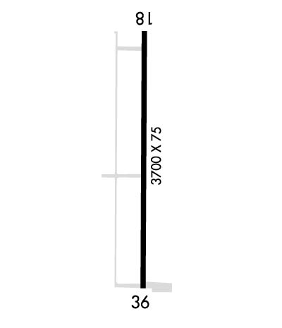
| Lat: N 2819.8 Long: W 08229.8 Elev: 80 Var: +02 Longest Runway: 3700 | ||
| CTAF: 122.8 | ||
| ||||||
|
| Rwy | Rwy | |||||||
| 3700x75 | 3400' | 3700x75 | 2800' | |||||
| Runway ID | Single Wheel | Double Wheel | Double Tandem Wheel | Dual Double Wheel |
| 18/36 | N/A | N/A | N/A | N/A |
| These numbers are Advisory and are not limits. The Airport Manager should have more accurate Weight Limits | ||||
| FltPlan does not have IFR approach charts available for KX05. |
 Airport Diagram might not be current. | |
| Facility Name: | PILOT COUNTRY |
| City Name: | BROOKSVILLE |
| County: | PASCO |
| State abbrev: | FL |
| State Name: | FLORIDA |
| Ownership: | PRIVATELY OWNED |
| Use: | OPEN TO THE PUBLIC |
| Owner's Name: | MARK TWAALFHOVEN |
| Address: | 11729 DRIVER LANE |
| SPRING HILL, FL 34610 | |
| Owner's Phone: | 408-966-4439 |
| Manager's Name: | ALEDA BUDD; LTR OF MGMT DESIGNATION SMTD. |
| Address: | 11500 PILOT COUNTRY DRIVE |
| SPRINGHILL, FL 34610 | |
| Phone: | 813-235-9000 |
| FAA Region: | SOUTHERN |
| FAA Field Office: | ORL |
| Date | Sunrise | Sunset |
|---|---|---|
| 09/24/21 Friday | 7:19 | 19:24 |
| 09/25/21 Saturday | 7:20 | 19:23 |
| 09/26/21 Sunday | 7:20 | 19:22 |
| 09/27/21 Monday | 7:21 | 19:21 |
| 09/28/21 Tuesday | 7:21 | 19:20 |
| 09/29/21 Wednesday | 7:22 | 19:18 |
| 09/30/21 Thursday | 7:22 | 19:17 |
| 10/01/21 Friday | 7:23 | 19:16 |
| 10/02/21 Saturday | 7:23 | 19:15 |
| 10/03/21 Sunday | 7:24 | 19:14 |
| 10/04/21 Monday | 7:24 | 19:13 |
| 10/05/21 Tuesday | 7:25 | 19:12 |
| 10/06/21 Wednesday | 7:25 | 19:10 |
| 10/07/21 Thursday | 7:26 | 19:09 |
| Airport Attendance Schedule | 7 Days A Week 0800-1730 |
| Airport Status | OPERATIONAL (This Status can change at any time - please check NOTAMS) |
| Airport Lighting Schedule | ACTVT LIRL RY 18/36 - CTAF. |
| Airport Storage Available | Tie Downs, Hanger |
| Extra Services Available | Flight Instruction, Aircraft Rental |
| Wind Indicator | YES - (lighted) |
| Control Tower | NO |
| CTAF Frequency | 122.800 |
| Unicom Frequency | 122.800 |
| Rotating Beacon Color | CLEAR-GREEN (Light Land Airport) |
| Segmented Circle | NO |
| Landing Fee | NO |
| Airport Inspected | STATE - performed by STATE AERONAUTICAL PERSONNEL |
| Inspection Date | 12/11/2017 |
| Type of Fuel Available | Grade 100LL; -10FUEL 24 HR CREDIT CARD SVC AVBL. |
| Airframe Repair Service | MINOR |
| Power Plant Repair Service | MINOR |
| Latitude | N2819.8 |
| Longitude | W08229.8 (ESTIMATED) |
| Arpt Elevation | 80ft (SURVEYED) |
| Magnetic Variation | 02W |
| 13 miles S | of BROOKSVILLE |
| Traffic Pattern Altitude | |
| Sectional Chart | JACKSONVILLE |
| Operations (Reported) | Yearly | Avg. Daily |
|---|---|---|
| General Aviation Transient | 3050 | 8 |
| General Aviation Local | 7100 | 19 |
| Air Taxi | 0 | 0 |
| Commerical | 0 | 0 |
| Commuter | 0 | 0 |
| Military | 26 | 0 |
| Aircraft based on Field | |
|---|---|
| General Aviation Singles | 108 |
| General Aviation Multi | 5 |
| Jet Aircraft | 0 |
| General Aviation Helicopters | 2 |
| Military Aircraft | 0 |
| Gliders | 1 |
| Ultralights | 2 |
| FSS on field | NO |
| FSS tie-in | SAINT PETERSBURG |
| FSS Phone | 1-800-WX-BRIEF |
| Who issues Notams | PIE |
| Notam D service at airport | YES |
| ARTCC Name | JACKSONVILLE |
| Airport Certification | |
| Aircraft Rescue & Firefighting Index | None |
| Airport of Entry | No |
| Custom Landing Rights | No |
| Joint Civil/Military | No |
| Military Landing rights | No |
| BIRDS INVOF RY. |
| 18 FT FUEL TANK 90 FT FROM END OF RY 105 FT R OF CNTRLN. |
| FOR CD CTC TAMPA APCH AT 813-878-2528. |
| Runway: 18 | Runway: 36 | ||
| Mag heading: | N/A | Mag heading: | N/A |
| Approach: | Approach: | ||
| Pattern: | Left Traffic | Pattern: | Left Traffic |
| Markings: | BASIC | Markings: | BASIC |
| Marking Condition: | GOOD | Marking Condition: | GOOD |
| Arresting Dev: | Arresting Dev: | ||
| Lat & Long: | Lat. & Long.: | ||
| Elev: | N/A | Elev: | N/A |
| TCH: | TCH: | ||
| Visual Glide Path: | Visual Glide Path: | ||
| Displaced Threshold: | 300 feet | Displaced Threshold: | 900 feet |
| Touchdown Zone: | NO | Touchdown Zone: | NO |
| Touchdown Elev.: | Touchdown Elev.: | ||
| Visual Glide Slope: | Visual Glide Slope: | ||
| RVR Equipment: | RVR Equipment: | ||
| RVV Equipment: | NO | RVV Equipment: | NO |
| Approach Lights: | Approach Lights: | ||
| REIL: | NO | REIL: | NO |
| Centerline Lights: | NO | Centerline Lights: | NO |
| Touchdown lights: | NO | Touchdown lights: | NO |
| Runway Category: | Runway with a Visual Approach | Runway Category: | Runway with a Visual Approach |
| Declared Distances: | Declared Distances: | ||
| Obstructions: | TREES | Obstructions: | ROAD |
| Marked: | NOT Marked/Lighted | Marked: | NOT Marked/Lighted |
| Clearance slope: | 20:1 | Clearance slope: | 5:1; RWY 36 APCH RATIO 21:1 TO THE DSPLCD THR DUE TO 67 FT TREES 1225 FT FM END OF RWY 130 FT RIGHT OF CNTRLN. |
| Obstruction height: | 72 feet AGL | Obstruction height: | 10 feet AGL |
| Dist. from runway: | 1695 feet | Dist. from runway: | 255 feet; FUEL TANK 110 FT E OF RWY 36 CNTRLN FIRST 150 FT. |
| Centerline offset: | Centerline offset: | ||
| Comments: | Comments: |
Thanks for using FltPlan.com
all rights reserved © 1999-2021 by Flight Plan LLC
