
| LA CROSSE MUNI LA CROSSE WI |
| |
| Lat: N 4352.8 Long: W 09115.4 Elev: 655 Var: +01 Longest Runway: 8742 | ||
| Dept. ATIS: 124.95 Arr. ATIS: 124.95 Ground: 121.8 Tower: 118.45 | ||
| ||||||
| ||||||
|
| Rwy | Rwy | |||||||
| 5199x150 | 5199' | 5199x150 | 5199' | |||||
| 6050x150 | 6050' | 6050x150 | 5311' | |||||
| 8742x150 | 8742' | 111.10 - 180° | 8742x150 | 7611' | ||||
| Runway ID | Single Wheel | Double Wheel | Double Tandem Wheel | Dual Double Wheel |
| 04/22 | 65,000 | 110,000 | 190,000 | N/A |
| 13/31 | 125,000 | 190,000 | 430,000 | N/A |
| 18/36 | 125,000 | 190,000 | 430,000 | 850,000 |
| These numbers are Advisory and are not limits. The Airport Manager should have more accurate Weight Limits | ||||
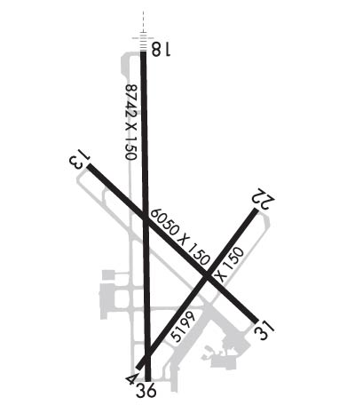 Airport Diagram might not be current. | |
| Facility Name: | LA CROSSE RGNL |
| City Name: | LA CROSSE |
| County: | LA CROSSE |
| State abbrev: | WI |
| State Name: | WISCONSIN |
| Ownership: | PUBLICLY OWNED |
| Use: | OPEN TO THE PUBLIC |
| Owner's Name: | CITY OF LA CROSSE |
| Address: | 2850 AIRPORT ROAD |
| LA CROSSE, WI 54603 | |
| Owner's Phone: | 608-789-7464 |
| Manager's Name: | IAN TURNER |
| Address: | 2850 AIRPORT ROAD |
| LA CROSSE, WI 54603-1264 | |
| Phone: | 608-789-7456 |
| FAA Region: | GREAT LAKES |
| FAA Field Office: | CHI |
| Date | Sunrise | Sunset |
|---|---|---|
| 09/24/21 Friday | 6:54 | 18:59 |
| 09/25/21 Saturday | 6:55 | 18:57 |
| 09/26/21 Sunday | 6:57 | 18:55 |
| 09/27/21 Monday | 6:58 | 18:54 |
| 09/28/21 Tuesday | 6:59 | 18:52 |
| 09/29/21 Wednesday | 7:00 | 18:50 |
| 09/30/21 Thursday | 7:01 | 18:48 |
| 10/01/21 Friday | 7:02 | 18:46 |
| 10/02/21 Saturday | 7:04 | 18:44 |
| 10/03/21 Sunday | 7:05 | 18:43 |
| 10/04/21 Monday | 7:06 | 18:41 |
| 10/05/21 Tuesday | 7:07 | 18:39 |
| 10/06/21 Wednesday | 7:08 | 18:37 |
| 10/07/21 Thursday | 7:09 | 18:36 |
| Airport Attendance Schedule | 7 Days A Week 0600-2100; FOR ATTENDANT OTHER HOURS CALL 608-783-8359. |
| Airport Status | OPERATIONAL (This Status can change at any time - please check NOTAMS) |
| Airport Lighting Schedule | WHEN ATCT CLSD MIRL RWY 13/31 PRESET LOW INTST; TO INCR INTST & ACTVT MALSR RWY 18; REIL RWY 13, 31, 36; MIRL RWY 13/31; HIRL RWY 18/36, RWY 04/22 - CTAF. PAPI RWY 04, 18, & 22; VASI RWY 13, 31, & 36 OPR CONSLY. |
| Airport Storage Available | Tie Downs, Hanger |
| Extra Services Available | Air Freight, Charter, Flight Instruction, Aircraft Rental, Aircraft Sales |
| Wind Indicator | YES - (lighted) |
| Control Tower | YES |
| CTAF Frequency | 118.450 |
| Unicom Frequency | 122.950 |
| Rotating Beacon Color | CLEAR-GREEN (Light Land Airport) |
| Segmented Circle | YES |
| Landing Fee | NO |
| Airport Inspected | FEDERAL - performed by FAA AIRPORTS FIELD PERSONNEL |
| Inspection Date | 09/11/2019 |
| Type of Fuel Available | Grade 100LL, JET A (freeze point -40C) |
| Airframe Repair Service | MAJOR |
| Power Plant Repair Service | MAJOR |
| Latitude | N4352.8 |
| Longitude | W09115.4 (ESTIMATED) |
| Arpt Elevation | 655ft (SURVEYED) |
| Magnetic Variation | 01W |
| 4 miles NW | of LA CROSSE |
| Traffic Pattern Altitude | |
| Sectional Chart | CHICAGO |
| Operations (Reported) | Yearly | Avg. Daily |
|---|---|---|
| General Aviation Transient | 9632 | 26 |
| General Aviation Local | 4757 | 13 |
| Air Taxi | 4060 | 11 |
| Commerical | 962 | 3 |
| Commuter | 0 | 0 |
| Military | 292 | 1 |
| Aircraft based on Field | |
|---|---|
| General Aviation Singles | 60 |
| General Aviation Multi | 5 |
| Jet Aircraft | 8 |
| General Aviation Helicopters | 0 |
| Military Aircraft | 0 |
| Gliders | 0 |
| Ultralights | 0 |
| FSS on field | NO |
| FSS tie-in | GREEN BAY |
| FSS Phone | 1-800-WX-BRIEF |
| Who issues Notams | LSE |
| Notam D service at airport | YES |
| ARTCC Name | MINNEAPOLIS |
| Airport Certification | AIRPORT RECEIVING SCHEDULED AIR CARRIER SERVICE FROM CARRIERS CERTIFICATED BY THE CIVIL AERONAUTICS BOARD |
| Aircraft Rescue & Firefighting Index | AIRPORT HAS A CERTIFICATE UNDER CFR PART 139 |
| Airport of Entry | No |
| Custom Landing Rights | No |
| Joint Civil/Military | No |
| Military Landing rights | YES |
| NATIONAL PLAN OF INTEGRATED AIRPORT SYSTEMS (NPIAS) |
| GRANT AGREEMENTS UNDER FAAP/ADAP/AIP |
| CONVEYANCE UNDER SCETION 16, FEDERAL AIRPORT ACT OF 1946 OR SECTION 23, AIRPORT AND AIRWAY DEVELOPMENT ACT OF 1970 |
| ASSURANCES PURSUANT TO TITLE VI, CIVIL RIGHTS ACT OF 1964 |
| AGREEMENT UNDER DLAND OR DCLA HAS EXPIRED. |
| TOWER, 1390 FT AGL 6NM SW. |
| NUMEROUS TOWERS UP TO 836 FT AGL; 4NM SE. |
| DEER; WATERFOWL & OTHER BIRDS ON & INVOF ARPT. HVY CONCENTRATIONS OF WATERFOWL SPRING & FALL. |
| HLDG PSN FOR THE WEST SIDE OF RWY 36 APCH END IS SET BACK ON TWY C. SEE HS-1 ON ARPT DIAGRAM. |
| COLD TEMPERATURE AIRPORT. ALTITUDE CORRECTION REQUIRED AT OR BELOW -22C. |
| RWY INCURSION RISK. PILOTS ARE REMINDED TO REVIEW ARPT HOT SPOT INFO BFR TXG FOR DEP AND BFR LNDG. SEE TPP ARPT DIAGRAM AND CHART SUPPL SXN ON HOT SPOTS FOR ADDNL INFO. |
| WRONG RWY ARRIVAL RISK, RWY 4 AND 36 APCH ENDS ARE CLOSELY ALIGNED. SEE TPP ARPT DIAGRAM. |
| FOR CD WHEN ATCT IS CLSD CTC ON FSS ON RCO FREQ; IF UNA CTC MINNEAPOLIS ARTCC AT 651-463-5588. |
Airport Communications & Frequencies:
| |||||||||||||||||
| Runway: 04 | Runway: 22 | ||
| Mag heading: | 37° | Mag heading: | 217° |
| Rwy Slope: | .13% Up | Rwy Slope: | -.13% Down |
| Approach: | Approach: | ||
| Pattern: | Left Traffic | Pattern: | Left Traffic |
| Markings: | NONPRECISION INSTRUMENT | Markings: | NONPRECISION INSTRUMENT |
| Marking Condition: | FAIR | Marking Condition: | FAIR |
| Arresting Dev: | Arresting Dev: | ||
| Lat & Long: | N4352.2 W09115.6 | Lat. & Long.: | N4352.9 W09114.9 |
| Elev: | 646.6 ft. MSL | Elev: | 653.3 ft. MSL |
| TCH: | 29 ft. AGL | TCH: | 28 ft. AGL |
| Visual Glide Path: | 4.00 degrees | Visual Glide Path: | 4.00 degrees |
| Displaced Threshold: | No | Displaced Threshold: | No |
| Touchdown Zone: | YES | Touchdown Zone: | YES |
| Touchdown Elev.: | 653.8 feet | Touchdown Elev.: | 653.9 feet |
| Visual Glide Slope: | 4-Light PAPI on LEFT side of Runway | Visual Glide Slope: | 4-Light PAPI on LEFT side of Runway |
| RVR Equipment: | RVR Equipment: | ||
| RVV Equipment: | NO | RVV Equipment: | NO |
| Approach Lights: | Approach Lights: | ||
| REIL: | NO | REIL: | NO |
| Centerline Lights: | NO | Centerline Lights: | NO |
| Touchdown lights: | NO | Touchdown lights: | NO |
| Runway Category: | Runway with a Non-precision Approach having visibility minimums greater than 3/4 mile | Runway Category: | Runway with a Non-precision Approach having visibility minimums greater than 3/4 mile |
| Declared Distances: | TORA:5199' TODA:5199' ASDA:5199' LDA:5199' | Declared Distances: | TORA:5199' TODA:5199' ASDA:5199' LDA:5199' |
| Obstructions: | POLE | Obstructions: | TREES |
| Marked: | NOT Marked/Lighted | Marked: | NOT Marked/Lighted |
| Clearance slope: | 28:1 | Clearance slope: | 18:1 |
| Obstruction height: | 47 feet AGL | Obstruction height: | 43 feet AGL |
| Dist. from runway: | 1516 feet | Dist. from runway: | 994 feet |
| Centerline offset: | 320 left of centerline | Centerline offset: | 350 feet right of centerline |
| Comments: | Comments: |
| Runway: 13 | Runway: 31 | ||
| Mag heading: | 135° | Mag heading: | 315° |
| Rwy Slope: | -.08% Down | Rwy Slope: | .08% Up |
| Approach: | Approach: | ||
| Pattern: | Left Traffic | Pattern: | Left Traffic |
| Markings: | NONPRECISION INSTRUMENT | Markings: | NONPRECISION INSTRUMENT |
| Marking Condition: | GOOD | Marking Condition: | GOOD |
| Arresting Dev: | Arresting Dev: | ||
| Lat & Long: | N4353.1 W09115.9 | Lat. & Long.: | N4352.4 W09114.9 |
| Elev: | 655.4 ft. MSL | Elev: | 650.5 ft. MSL |
| TCH: | 33 ft. AGL | TCH: | 44 ft. AGL |
| Visual Glide Path: | 3.00 degrees | Visual Glide Path: | 3.85 degrees |
| Displaced Threshold: | No | Displaced Threshold: | 739 feet |
| Touchdown Zone: | YES | Touchdown Zone: | YES |
| Touchdown Elev.: | 655.4 feet | Touchdown Elev.: | 654.1 feet |
| Visual Glide Slope: | 4-BOX VASI ON LEFT SIDE OF RUNWAY | Visual Glide Slope: | 4-BOX VASI ON LEFT SIDE OF RUNWAY; VASI UNUSBL BYD 9 DEGS RIGHT OF CNTRLN. |
| RVR Equipment: | RVR Equipment: | ||
| RVV Equipment: | NO | RVV Equipment: | NO |
| Approach Lights: | Approach Lights: | ||
| REIL: | YES | REIL: | YES |
| Centerline Lights: | NO | Centerline Lights: | NO |
| Touchdown lights: | NO | Touchdown lights: | NO |
| Runway Category: | Runway with a Non-precision Approach having visibility minimums greater than 3/4 mile | Runway Category: | Runway with a Non-precision Approach having visibility minimums greater than 3/4 mile |
| Declared Distances: | TORA:5310' TODA:5310' ASDA:5310' LDA:5310' | Declared Distances: | TORA:6050' TODA:6050' ASDA:6050' LDA:5310' |
| Obstructions: | TREES | Obstructions: | TREES |
| Marked: | NOT Marked/Lighted | Marked: | NOT Marked/Lighted |
| Clearance slope: | 26:1 | Clearance slope: | 26:1; RWY 31 APCH RATIO 24:1 AT DSPLCD THLD. |
| Obstruction height: | 68 feet AGL | Obstruction height: | 40 feet AGL |
| Dist. from runway: | 1995 feet | Dist. from runway: | 1250 feet |
| Centerline offset: | 327 right of centerline | Centerline offset: | 350 feet left of centerline |
| Comments: | Comments: |
| Runway: 18 | Runway: 36 | ||
| Mag heading: | 180° | Mag heading: | 360° |
| Rwy Slope: | -.06% Down | Rwy Slope: | .06% Up |
| Approach: | ILS | Approach: | |
| Pattern: | Left Traffic | Pattern: | Left Traffic |
| Markings: | PRECISION INSTRUMENT | Markings: | PRECISION INSTRUMENT |
| Marking Condition: | GOOD | Marking Condition: | GOOD |
| Arresting Dev: | Arresting Dev: | ||
| Lat & Long: | N4353.6 W09115.5 | Lat. & Long.: | N4352.2 W09115.5 |
| Elev: | 652.5 ft. MSL | Elev: | 647.2 ft. MSL |
| TCH: | 55 ft. AGL | TCH: | 28 ft. AGL |
| Visual Glide Path: | 3.00 degrees | Visual Glide Path: | 3.00 degrees |
| Displaced Threshold: | No | Displaced Threshold: | 1131 feet |
| Touchdown Zone: | YES | Touchdown Zone: | YES |
| Touchdown Elev.: | 652.7 feet | Touchdown Elev.: | 652.6 feet |
| Visual Glide Slope: | 4-Light PAPI on LEFT side of Runway | Visual Glide Slope: | 4-BOX VASI ON LEFT SIDE OF RUNWAY |
| RVR Equipment: | RVR Equipment: | ||
| RVV Equipment: | NO | RVV Equipment: | NO |
| Approach Lights: | MALSR - 1,400 foot medium intensity approach lighting system with runway alignment indicator lights | Approach Lights: | |
| REIL: | NO | REIL: | YES |
| Centerline Lights: | NO | Centerline Lights: | NO |
| Touchdown lights: | NO | Touchdown lights: | NO |
| Runway Category: | Precision Instrument Runway | Runway Category: | Runway with a Non-precision Approach having visibility minimums greater than 3/4 mile |
| Declared Distances: | TORA:8742' TODA:8742' ASDA:8536' LDA:8536' | Declared Distances: | TORA:8742' TODA:8742' ASDA:8557' LDA:7426' |
| Obstructions: | TREE | Obstructions: | TREE |
| Marked: | NOT Marked/Lighted | Marked: | NOT Marked/Lighted |
| Clearance slope: | 47:1 | Clearance slope: | 28:1; RY 36 APCH RATIO 50:1 AT DSPLCD THLD. |
| Obstruction height: | 69 feet AGL | Obstruction height: | 48 feet AGL |
| Dist. from runway: | 3443 feet | Dist. from runway: | 1522 feet |
| Centerline offset: | 790 right of centerline | Centerline offset: | 424 feet left of centerline |
| Comments: | Comments: |
Thanks for using FltPlan.com
all rights reserved © 1999-2021 by Flight Plan LLC
