
| MC CLELLAN AIRFIELD SACRAMENTO CA |
| |
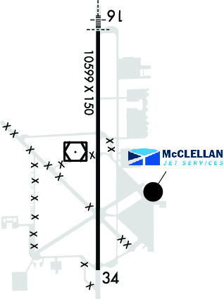
| Lat: N 3840.1 Long: W 12124.0 Elev: 77 Var: -17 Longest Runway: 10599 | ||
| Clr Del: 119.82 AWOS: 125.97 CTAF: 122.97 | ||
| |||||||||||||||||||||||||||||||||||||||||||||||||||||||||||||||||||||
| |||||||||||||||||||||||||||||||||||||||||||||||||||||||||||||||||||||
| |||||||||||||||||||||||||||||||||||||||||||||||||||||||||||||||||||||
| FBOs at nearby airports who want your business: | ||||||||||
| ||||||||||
| Rwy | Rwy | |||||||
| 10599x150 | 10599' | 109.70 - 163° | 10599x150 | 10599' | 109.70 - 344° | |||
| Runway ID | Single Wheel | Double Wheel | Double Tandem Wheel | Dual Double Wheel |
| 16/34 | 155,000 | 300,000 | 500,000 | N/A |
| H1 | N/A | N/A | N/A | N/A |
| H2 | N/A | N/A | N/A | N/A |
| H3 | N/A | N/A | N/A | N/A |
| H4 | N/A | N/A | N/A | N/A |
| These numbers are Advisory and are not limits. The Airport Manager should have more accurate Weight Limits | ||||
 Airport Diagram might not be current. | |
| Facility Name: | MC CLELLAN AIRFIELD |
| City Name: | SACRAMENTO |
| County: | SACRAMENTO |
| State abbrev: | CA |
| State Name: | CALIFORNIA |
| Ownership: | PRIVATELY OWNED |
| Use: | OPEN TO THE PUBLIC |
| Owner's Name: | MC CLELLAN BUSINESS PARK, LLC |
| Address: | 3028 PEACEKEEPER WAY |
| MCCLELLAN, CA 95652-2502 | |
| Owner's Phone: | 916-570-5317 |
| Manager's Name: | JOSHUA HENRY |
| Address: | 3028 PEACEKEEPER WAY |
| MCCLELLAN, CA 95652-2502 | |
| Phone: | 916-570-5317 |
| FAA Region: | WESTERN-PACIFIC |
| FAA Field Office: | SFO |
| Date | Sunrise | Sunset |
|---|---|---|
| 03/27/25 Thursday | 6:58 | 19:24 |
| 03/28/25 Friday | 6:57 | 19:25 |
| 03/29/25 Saturday | 6:55 | 19:26 |
| 03/30/25 Sunday | 6:54 | 19:27 |
| 03/31/25 Monday | 6:52 | 19:28 |
| 04/01/25 Tuesday | 6:51 | 19:29 |
| 04/02/25 Wednesday | 6:49 | 19:30 |
| 04/03/25 Thursday | 6:48 | 19:31 |
| 04/04/25 Friday | 6:46 | 19:32 |
| 04/05/25 Saturday | 6:45 | 19:33 |
| 04/06/25 Sunday | 6:43 | 19:34 |
| 04/07/25 Monday | 6:41 | 19:35 |
| 04/08/25 Tuesday | 6:40 | 19:36 |
| 04/09/25 Wednesday | 6:38 | 19:37 |
| Airport Attendance Schedule | CONTINUOUS |
| Airport Status | OPERATIONAL (This Status can change at any time - please check NOTAMS) |
| Airport Lighting Schedule | ACTVT MALSR RWY 16; HIRL RWY 16/34; TWY LGTS - CTAF. PAPI RWYS 16 & 34 OPR CONSLY. |
| Airport Storage Available | Tie Downs, Hanger |
| Extra Services Available | Air Freight, Air Ambulance, Avionics, Cargo Handling, Charter, Aircraft Sales |
| Wind Indicator | YES - (unlit) |
| Control Tower | NO |
| CTAF Frequency | 122.975 |
| Unicom Frequency | 122.975 |
| Rotating Beacon Color | WG |
| Segmented Circle | YES |
| Landing Fee | NO |
| Airport Inspected | No Inspection Data Available performed by STATE AERONAUTICAL PERSONNEL |
| Inspection Date | 11/14/2024 |
| Type of Fuel Available | Grade 100LL, JET A (freeze point -40C), JET A; -10SELF-SERVICE 100LL FUEL WEST SIDE TWY KILO. |
| Airframe Repair Service | MAJOR |
| Power Plant Repair Service | MAJOR |
| Latitude | N3840.1 |
| Longitude | W12124.0 (ESTIMATED) |
| Arpt Elevation | 76ft (SURVEYED) |
| Magnetic Variation | 17E |
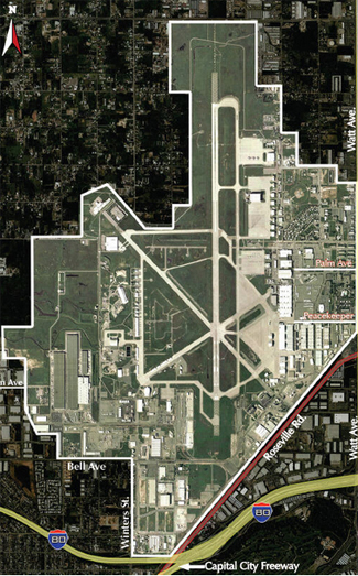
| 6 miles NE | of SACRAMENTO |
| Traffic Pattern Altitude | 1076 |
| Sectional Chart | SAN FRANCISCO |
| Operations (Reported) | Yearly | Avg. Daily |
|---|---|---|
| General Aviation Transient | 0 | 0 |
| General Aviation Local | 0 | 0 |
| Air Taxi | 0 | 0 |
| Commerical | 0 | 0 |
| Commuter | 0 | 0 |
| Military | 0 | 0 |
| Aircraft based on Field | |
|---|---|
| General Aviation Singles | 0 |
| General Aviation Multi | 0 |
| Jet Aircraft | 0 |
| General Aviation Helicopters | 0 |
| Military Aircraft | 0 |
| Gliders | 0 |
| Ultralights | 0 |
| FSS on field | NO |
| FSS tie-in | RANCHO MURIETA |
| FSS Phone | 1-800-WX-BRIEF |
| Who issues Notams | MCC |
| Notam D service at airport | YES |
| ARTCC Name | OAKLAND |
| Airport Certification | |
| Aircraft Rescue & Firefighting Index | None |
| Airport of Entry | No |
| Custom Landing Rights | YES |
| Joint Civil/Military | No |
| Military Landing rights | YES |
| NATIONAL PLAN OF INTEGRATED AIRPORT SYSTEMS (NPIAS) |
| 900 FT ASPH OVRN SE END RY 16 & 1000 FT ASPH OVRN NW END RY 34. |
| MILITARY USE: TRAN ACFT PPR FOR USCG RAMP C916-643-7659, WITH CREW LIST FOR ARR/DEP PAX. |
| RY 16 CALM WIND RWY. |
| TWYS E,F,G NSTD TWY EDGE LGTG. |
| FOR CD CTC NORCAL APCH AT 916-361-6874. |
| FLD CONDS-RWY, TWY & APRON GOOD. |
| STRICT ADHERENCE TO PUBLD TFC PATS RCMD FOR NS ABTMT PURPOSES. |
| TOUCH/GO LNDG FOR C5 PROHIBITED. |
| DURG INCREASED BIRD CONDITIONS THE POTENTIAL FOR BIRD CONGESTION EXIST AT BOTH ARR/DEP ENDS RY 16/34. |
| ALL ACFT EXIT RY TO THE EAST. SELF SRV 100LL W SIDE TW KILO. |
| MILITARY USE: FUEL - A+ (MCCLELLAN JET SVC, C916-641-8970.) |
| RWY 16/3 4 NSTD HIRL LCTD 25 FT FM RY EDGE MARKINGS. |
Airport Communications & Frequencies:
| |||||||||||||||||||
| Runway: 16 | Runway: 34 | ||
| Mag heading: | 163° | Mag heading: | 343° |
| Rwy Slope: | -.07% Down | Rwy Slope: | .07% Up |
| Approach: | ILS | Approach: | ILS |
| Pattern: | Right Traffic | Pattern: | Left Traffic |
| Markings: | PRECISION INSTRUMENT | Markings: | PRECISION INSTRUMENT |
| Marking Condition: | GOOD | Marking Condition: | GOOD |
| Arresting Dev: | Arresting Dev: | ||
| Lat & Long: | N3840.9 W12124.0 | Lat. & Long.: | N3839.2 W12124.0 |
| Elev: | 76.8 ft. MSL | Elev: | 69.9 ft. MSL |
| TCH: | 52 ft. AGL | TCH: | 53 ft. AGL |
| Visual Glide Path: | 3.00 degrees | Visual Glide Path: | 3.00 degrees |
| Displaced Threshold: | No | Displaced Threshold: | No |
| Touchdown Zone: | YES | Touchdown Zone: | YES |
| Touchdown Elev.: | 76.8 feet | Touchdown Elev.: | 72.0 feet |
| Visual Glide Slope: | 4-Light PAPI on LEFT side of Runway | Visual Glide Slope: | 4-Light PAPI on LEFT side of Runway |
| RVR Equipment: | RVR Equipment: | ||
| RVV Equipment: | NO | RVV Equipment: | NO |
| Approach Lights: | MALSR - 1,400 foot medium intensity approach lighting system with runway alignment indicator lights | Approach Lights: | |
| REIL: | NO | REIL: | NO |
| Centerline Lights: | NO | Centerline Lights: | NO |
| Touchdown lights: | NO | Touchdown lights: | NO |
| Runway Category: | Precision Instrument Runway | Runway Category: | Runway with a Non-precision Approach having visibility minimums greater than 3/4 mile |
| Declared Distances: | Declared Distances: | ||
| Obstructions: | Obstructions: | TOWER | |
| Marked: | Marked: | NOT Marked/Lighted | |
| Clearance slope: | 50:1 | Clearance slope: | 42:1 |
| Obstruction height: | Obstruction height: | 90 feet AGL | |
| Dist. from runway: | Dist. from runway: | 4000 feet | |
| Centerline offset: | Centerline offset: | 175 feet left of centerline | |
| Comments: | Comments: |
Thanks for using FltPlan.com
all rights reserved © 1999-2025 by Flight Plan LLC