
| KEY FIELD MERIDIAN MS |
| |
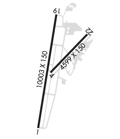
| Lat: N 3220.0 Long: W 08845.1 Elev: 298 Var: +02 Longest Runway: 10003 | ||
| Clr Del: 121.9 Dept. ATIS: 126.47 Arr. ATIS: 126.47 AWOS: 126.47 Ground: 121.9 Tower: 133.97 | ||
| ||||||||||||||||||||||||||||||||||||||||||||
| ||||||||||||||||||||||||||||||||||||||||||||
| ||||||||||||||||||||||||||||||||||||||||||||
| Rwy | Rwy | |||||||
| 10003x150 | 9013' | 110.10 - 011° | 10003x150 | 9013' | 111.35 - 191° | |||
| 5052x150 | 5052' | 5052x150 | 5052' | |||||
| Runway ID | Single Wheel | Double Wheel | Double Tandem Wheel | Dual Double Wheel |
| 01/19 | 120,000 | 250,000 | 550,000 | N/A |
| 04/22 | 120,000 | 213,000 | 345,000 | N/A |
| These numbers are Advisory and are not limits. The Airport Manager should have more accurate Weight Limits | ||||
 Airport Diagram might not be current. | |
| Facility Name: | KEY FLD |
| City Name: | MERIDIAN |
| County: | LAUDERDALE |
| State abbrev: | MS |
| State Name: | MISSISSIPPI |
| Ownership: | PUBLICLY OWNED |
| Use: | OPEN TO THE PUBLIC |
| Owner's Name: | MERIDIAN ARPT AUTH |
| Address: | 2811A AIRPORT BLVD |
| MERIDIAN, MS 39307 | |
| Owner's Phone: | 601-482-0364 |
| Manager's Name: | TOM WILLIAMS |
| Address: | 2811A AIRPORT BLVD |
| MERIDIAN, MS 39307 | |
| Phone: | 601-482-0364 |
| FAA Region: | SOUTHERN |
| FAA Field Office: | JAN |
| Date | Sunrise | Sunset |
|---|---|---|
| 02/13/25 Thursday | 6:40 | 17:39 |
| 02/14/25 Friday | 6:39 | 17:40 |
| 02/15/25 Saturday | 6:38 | 17:41 |
| 02/16/25 Sunday | 6:37 | 17:42 |
| 02/17/25 Monday | 6:36 | 17:43 |
| 02/18/25 Tuesday | 6:35 | 17:44 |
| 02/19/25 Wednesday | 6:34 | 17:44 |
| 02/20/25 Thursday | 6:33 | 17:45 |
| 02/21/25 Friday | 6:32 | 17:46 |
| 02/22/25 Saturday | 6:31 | 17:47 |
| 02/23/25 Sunday | 6:30 | 17:48 |
| 02/24/25 Monday | 6:29 | 17:49 |
| 02/25/25 Tuesday | 6:27 | 17:49 |
| 02/26/25 Wednesday | 6:26 | 17:50 |
| Airport Attendance Schedule | 7 Days A Week 0600-2200; FOR ATTENDANT AFT HRS CALL 601-693-7282. |
| Airport Status | OPERATIONAL (This Status can change at any time - please check NOTAMS) |
| Airport Lighting Schedule | ACTVT MALSR RWY 01 & 19; MIRL RWY 04/22; HIRL RWY 01/19; TWY LGTS - CTAF. |
| Airport Storage Available | Tie Downs, Hanger |
| Extra Services Available | Air Ambulance, Avionics, Cargo Handling, Charter, Flight Instruction, Aircraft Rental |
| Wind Indicator | YES - (lighted) |
| Control Tower | YES |
| CTAF Frequency | 133.975 |
| Unicom Frequency | 122.950 |
| Rotating Beacon Color | WG |
| Segmented Circle | YES |
| Landing Fee | NO |
| Airport Inspected | FEDERAL - performed by FAA AIRPORTS FIELD PERSONNEL |
| Inspection Date | 03/22/2024 |
| Type of Fuel Available | Grade 100LL, JET A (freeze point -40C)A++ |
| Airframe Repair Service | MAJOR |
| Power Plant Repair Service | MAJOR |
| Latitude | N3220.0 |
| Longitude | W08845.1 (ESTIMATED) |
| Arpt Elevation | 297ft (SURVEYED) |
| Magnetic Variation | 02W |
| 3 miles SW | of MERIDIAN |
| Traffic Pattern Altitude | |
| Sectional Chart | MEMPHIS |
| Operations (Reported) | Yearly | Avg. Daily |
|---|---|---|
| General Aviation Transient | 0 | 0 |
| General Aviation Local | 0 | 0 |
| Air Taxi | 0 | 0 |
| Commerical | 0 | 0 |
| Commuter | 0 | 0 |
| Military | 0 | 0 |
| Aircraft based on Field | |
|---|---|
| General Aviation Singles | 0 |
| General Aviation Multi | 0 |
| Jet Aircraft | 0 |
| General Aviation Helicopters | 0 |
| Military Aircraft | 0 |
| Gliders | 0 |
| Ultralights | 0 |
| FSS on field | NO |
| FSS tie-in | GREENWOOD |
| FSS Phone | 1-800-WX-BRIEF |
| Who issues Notams | MEI |
| Notam D service at airport | YES |
| ARTCC Name | MEMPHIS |
| Airport Certification | AIRPORT RECEIVING SCHEDULED AIR CARRIER SERVICE FROM CARRIERS CERTIFICATED BY THE CIVIL AERONAUTICS BOARD |
| Aircraft Rescue & Firefighting Index | AIRPORT HAS A CERTIFICATE UNDER CFR PART 139 |
| Airport of Entry | No |
| Custom Landing Rights | No |
| Joint Civil/Military | No |
| Military Landing rights | YES |
| NATIONAL PLAN OF INTEGRATED AIRPORT SYSTEMS (NPIAS) |
| GRANT AGREEMENTS UNDER FAAP/ADAP/AIP |
| SURPLUS PROPERTY AGREEMENT UNDER PUBLIC LAW 289 |
| ASSURANCES PURSUANT TO TITLE VI, CIVIL RIGHTS ACT OF 1964 |
| AGREEMENT UNDER DLAND OR DCLA HAS EXPIRED. |
| THIS AIRPORT HAS BEEN SURVEYED BY THE NATIONAL GEODETIC SURVEY. |
| ANG ATNDD 0700-1630 MON-FRI EXCP HOLS. |
| ANG LTD PRKG USE; RSC INFO AVBL FOR ANG OPS DURG NML DUTY HRS. ALL TRAN ACFT 48 HR PPR. OBO. |
| ANG RAMP CLSD EXC PPR, 601-484-9734/9714. ARNG DSN 293-2829 C601-696-8829. |
| BASH PHASE II PERIOD MAR-MAY, SEP-NOV. CTC AFLD MGMT OR COMD POST FOR CURRENT BIRD WATCH COND. |
| ANG PROVIDES ATC SERVICES AT KMEI. |
| FOR CD CTC MEMPHIS ARTCC AT 901-368-8453/8449. |
| RWY 01/1 9 NON-STD RESA DUE TO SFC VARNS. |
| RWY 01/1 9 DTHR CONC. |
| RWY 04/2 2 RWY REHABILITATED IN 2022. |
Airport Communications & Frequencies:
| |||||||||||||||||||||||||||||||||||||
| Runway: 01 | Runway: 19 | ||
| Mag heading: | 11° | Mag heading: | 191° |
| Rwy Slope: | .07% Up | Rwy Slope: | -.07% Down |
| Approach: | ILS | Approach: | ILS/DME |
| Pattern: | Left Traffic | Pattern: | Left Traffic |
| Markings: | PRECISION INSTRUMENT | Markings: | PRECISION INSTRUMENT |
| Marking Condition: | GOOD | Marking Condition: | GOOD |
| Arresting Dev: | Arresting Dev: | ||
| Lat & Long: | N3219.1 W08845.4 | Lat. & Long.: | N3220.7 W08845.1 |
| Elev: | 286.0 ft. MSL | Elev: | 293.5 ft. MSL |
| TCH: | 54 ft. AGL | TCH: | 69 ft. AGL |
| Visual Glide Path: | 3.00 degrees | Visual Glide Path: | 3.00 degrees |
| Displaced Threshold: | 990 feet | Displaced Threshold: | 990 feet |
| Touchdown Zone: | YES | Touchdown Zone: | YES |
| Touchdown Elev.: | 289.3 feet | Touchdown Elev.: | 293.1 feet |
| Visual Glide Slope: | 4-Light PAPI on LEFT side of Runway | Visual Glide Slope: | 4-Light PAPI on LEFT side of Runway |
| RVR Equipment: | TOUCHDOWN | RVR Equipment: | TOUCHDOWN |
| RVV Equipment: | NO | RVV Equipment: | NO |
| Approach Lights: | MALSR - 1,400 foot medium intensity approach lighting system with runway alignment indicator lights | Approach Lights: | MALSR - 1,400 foot medium intensity approach lighting system with runway alignment indicator lights |
| REIL: | NO | REIL: | NO |
| Centerline Lights: | NO | Centerline Lights: | NO |
| Touchdown lights: | NO | Touchdown lights: | NO |
| Runway Category: | Precision Instrument Runway | Runway Category: | Precision Instrument Runway |
| Declared Distances: | TORA:10003' TODA:10003' ASDA:10003' LDA:9013' | Declared Distances: | TORA:10003' TODA:10003' ASDA:10003' LDA:9013' |
| Runway: 04 | Runway: 22 | ||
| Mag heading: | 46° | Mag heading: | 226° |
| Rwy Slope: | .14% Up | Rwy Slope: | -.14% Down |
| Approach: | Approach: | ||
| Pattern: | Left Traffic | Pattern: | Left Traffic |
| Markings: | NONPRECISION INSTRUMENT | Markings: | NONPRECISION INSTRUMENT |
| Marking Condition: | GOOD | Marking Condition: | GOOD |
| Arresting Dev: | Arresting Dev: | ||
| Lat & Long: | N3219.9 W08845.2 | Lat. & Long.: | N3220.5 W08844.5 |
| Elev: | 289.8 ft. MSL | Elev: | 297.0 ft. MSL |
| TCH: | 45 ft. AGL | TCH: | 40 ft. AGL |
| Visual Glide Path: | 3.13 degrees | Visual Glide Path: | 3.00 degrees |
| Displaced Threshold: | No | Displaced Threshold: | No |
| Touchdown Zone: | YES | Touchdown Zone: | YES |
| Touchdown Elev.: | 295.1 feet | Touchdown Elev.: | 297.8 feet |
| Visual Glide Slope: | 2-Light PAPI on LEFT side of Runway | Visual Glide Slope: | 2-Light PAPI on LEFT side of Runway |
| RVR Equipment: | RVR Equipment: | ||
| RVV Equipment: | NO | RVV Equipment: | NO |
| Approach Lights: | Approach Lights: | ||
| REIL: | NO | REIL: | NO |
| Centerline Lights: | NO | Centerline Lights: | NO |
| Touchdown lights: | NO | Touchdown lights: | NO |
| Runway Category: | Runway with a Non-precision Approach having visibility minimums greater than 3/4 mile | Runway Category: | Runway with a Non-precision Approach having visibility minimums greater than 3/4 mile |
| Declared Distances: | TORA:5052' TODA:5052' ASDA:5052' LDA:5052' | Declared Distances: | TORA:5052' TODA:5052' ASDA:5052' LDA:5052' |
| Obstructions: | TREES | Obstructions: | POLE |
| Marked: | NOT Marked/Lighted | Marked: | NOT Marked/Lighted |
| Clearance slope: | 20:1 | Clearance slope: | 26:1 |
| Obstruction height: | 86 feet AGL | Obstruction height: | 35 feet AGL |
| Dist. from runway: | 1926 feet | Dist. from runway: | 1125 feet |
| Centerline offset: | 444 left of centerline | Centerline offset: | 390 feet right of centerline |
| Comments: | Comments: |
Thanks for using FltPlan.com
all rights reserved © 1999-2025 by Flight Plan LLC
