| BRANDYWINE WEST CHESTER PA |
| |
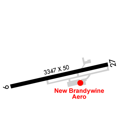
| Lat: N 3959.4 Long: W 07534.9 Elev: 465 Var: +12 Longest Runway: 3347 | ||
| Clr Del: 125.6 AWOS: 121.4 CTAF: 123.07 | ||
| ||||||||||||||||||||||||||||||||||||||||||||||||||||||||||||||||||||
| ||||||||||||||||||||||||||||||||||||||||||||||||||||||||||||||||||||
| ||||||||||||||||||||||||||||||||||||||||||||||||||||||||||||||||||||
| Rwy | Rwy | |||||||
| 3347x50 | 3222' | 3347x50 | 3098' | |||||
| Runway ID | Single Wheel | Double Wheel | Double Tandem Wheel | Dual Double Wheel |
| 09/27 | 10,000 | N/A | N/A | N/A |
| These numbers are Advisory and are not limits. The Airport Manager should have more accurate Weight Limits | ||||
 Airport Diagram might not be current. | |
| Facility Name: | BRANDYWINE RGNL |
| City Name: | WEST CHESTER |
| County: | CHESTER |
| State abbrev: | PA |
| State Name: | PENNSYLVANIA |
| Ownership: | PRIVATELY OWNED |
| Use: | OPEN TO THE PUBLIC |
| Owner's Name: | BRANDYWINE REGIONAL AIRPORT, INC |
| Address: | 1205 WARD AVE |
| WEST CHESTER, PA 19380 | |
| Owner's Phone: | 610-692-6100 |
| Manager's Name: | JOHN KASSAB |
| Address: | 1205 WARD AVE |
| WEST CHESTER, PA 19380 | |
| Phone: | 610-692-6100 |
| FAA Region: | EASTERN |
| FAA Field Office: | HAR |
| Date | Sunrise | Sunset |
|---|---|---|
| 02/09/25 Sunday | 7:03 | 17:31 |
| 02/10/25 Monday | 7:02 | 17:32 |
| 02/11/25 Tuesday | 7:01 | 17:33 |
| 02/12/25 Wednesday | 6:59 | 17:35 |
| 02/13/25 Thursday | 6:58 | 17:36 |
| 02/14/25 Friday | 6:57 | 17:37 |
| 02/15/25 Saturday | 6:56 | 17:38 |
| 02/16/25 Sunday | 6:54 | 17:39 |
| 02/17/25 Monday | 6:53 | 17:40 |
| 02/18/25 Tuesday | 6:52 | 17:42 |
| 02/19/25 Wednesday | 6:50 | 17:43 |
| 02/20/25 Thursday | 6:49 | 17:44 |
| 02/21/25 Friday | 6:48 | 17:45 |
| 02/22/25 Saturday | 6:46 | 17:46 |
| Airport Attendance Schedule | 7 Days A Week 0800-1700 |
| Airport Status | OPERATIONAL (This Status can change at any time - please check NOTAMS) |
| Airport Lighting Schedule | SS-SR |
| Airport Storage Available | Tie Downs |
| Extra Services Available | Air Ambulance, Charter, Flight Instruction, Aircraft Rental |
| Wind Indicator | YES - (lighted) |
| Control Tower | NO |
| CTAF Frequency | 123.075 |
| Unicom Frequency | 123.075 |
| Rotating Beacon Color | WG |
| Segmented Circle | NO |
| Landing Fee | YES; RAMP FEE OR FUEL. |
| Airport Inspected | STATE - performed by STATE AERONAUTICAL PERSONNEL |
| Inspection Date | 12/12/2024 |
| Type of Fuel Available | Grade 100LL, JET A (freeze point -40C) |
| Airframe Repair Service | MAJOR |
| Power Plant Repair Service | MAJOR |
| Latitude | N3959.4 |
| Longitude | W07534.9 (ESTIMATED) |
| Arpt Elevation | 464ft (ESTIMATED) |
| Magnetic Variation | 12W |
| 3 miles NE | of WEST CHESTER |
| Traffic Pattern Altitude | |
| Sectional Chart | WASHINGTON |
| Operations (Reported) | Yearly | Avg. Daily |
|---|---|---|
| General Aviation Transient | 0 | 0 |
| General Aviation Local | 0 | 0 |
| Air Taxi | 0 | 0 |
| Commerical | 0 | 0 |
| Commuter | 0 | 0 |
| Military | 0 | 0 |
| Aircraft based on Field | |
|---|---|
| General Aviation Singles | 0 |
| General Aviation Multi | 0 |
| Jet Aircraft | 0 |
| General Aviation Helicopters | 0 |
| Military Aircraft | 0 |
| Gliders | 0 |
| Ultralights | 0 |
| FSS on field | NO |
| FSS tie-in | WILLIAMSPORT |
| FSS Phone | 1-800-WX-BRIEF |
| Who issues Notams | IPT |
| Notam D service at airport | YES |
| ARTCC Name | NEW YORK |
| Airport Certification | |
| Aircraft Rescue & Firefighting Index | None |
| Airport of Entry | No |
| Custom Landing Rights | No |
| Joint Civil/Military | No |
| Military Landing rights | No |
| NATIONAL PLAN OF INTEGRATED AIRPORT SYSTEMS (NPIAS) |
| ASSURANCES PURSUANT TO TITLE VI, CIVIL RIGHTS ACT OF 1964 |
| TFC DEP RWY 27 CLIMB OUT STRAIGHT AHD TIL RCHG 1300 FT MSL; THEN TURN ON CRS FOR NOISE ABATEMENT. |
| BIRDS & DEER ON & INVOF ARPT. |
| FOR SVC AFT HRS CTC 610-842-3804. |
| FULL LENGTH PARALLEL TWY S OF RWY. |
| FOR CD CTC PHILADELPHIA APCH AT 800-354-9884. |
| RWY 27 CALM WIND RWY. |
Airport Communications & Frequencies:
| |||||||||||||||||||
| Runway: 09 | Runway: 27 | ||
| Mag heading: | 89° | Mag heading: | 269° |
| Rwy Slope: | .22% Up | Rwy Slope: | -.22% Down |
| Approach: | Approach: | ||
| Pattern: | Right Traffic | Pattern: | Left Traffic |
| Markings: | NONPRECISION INSTRUMENT | Markings: | NONPRECISION INSTRUMENT |
| Marking Condition: | GOOD | Marking Condition: | GOOD |
| Arresting Dev: | Arresting Dev: | ||
| Lat & Long: | N3959.3 W07535.3 | Lat. & Long.: | N3959.5 W07534.6 |
| Elev: | 453.3 ft. MSL | Elev: | 460.6 ft. MSL |
| TCH: | 23 ft. AGL | TCH: | 20 ft. AGL |
| Visual Glide Path: | 4.20 degrees | Visual Glide Path: | 3.00 degrees |
| Displaced Threshold: | 125 feet | Displaced Threshold: | 249 feet |
| Touchdown Zone: | YES | Touchdown Zone: | YES |
| Touchdown Elev.: | 464.6 feet | Touchdown Elev.: | 464.6 feet |
| Visual Glide Slope: | 2-Light PAPI on LEFT side of Runway; PAPI OPS CONS. | Visual Glide Slope: | 2-Light PAPI on LEFT side of Runway; PAPI OPS CONS. |
| RVR Equipment: | RVR Equipment: | ||
| RVV Equipment: | NO | RVV Equipment: | NO |
| Approach Lights: | Approach Lights: | ||
| REIL: | NO | REIL: | NO |
| Centerline Lights: | NO | Centerline Lights: | NO |
| Touchdown lights: | NO | Touchdown lights: | NO |
| Runway Category: | Runway with a Non-precision Approach | Runway Category: | Runway with a Non-precision Approach |
| Declared Distances: | Declared Distances: | ||
| Obstructions: | TREES | Obstructions: | |
| Marked: | NOT Marked/Lighted | Marked: | |
| Clearance slope: | 19:1; APCH RATIO 20:1 TO DTHR. | Clearance slope: | 20:1 |
| Obstruction height: | 170 feet AGL | Obstruction height: | |
| Dist. from runway: | 3512 feet | Dist. from runway: | |
| Centerline offset: | 307 left of centerline | Centerline offset: | |
| Comments: | Comments: | ROAD TRAVERSING THE 200 FT PRIMARY SFC AREA BYD EOR; ROAD RISES TO +13 FT AT A POINT 14 FT FROM EOR 265 FT R. |
Thanks for using FltPlan.com
all rights reserved © 1999-2025 by Flight Plan LLC