
| OSCODA-WURTSMITH OSCODA MI |
| |
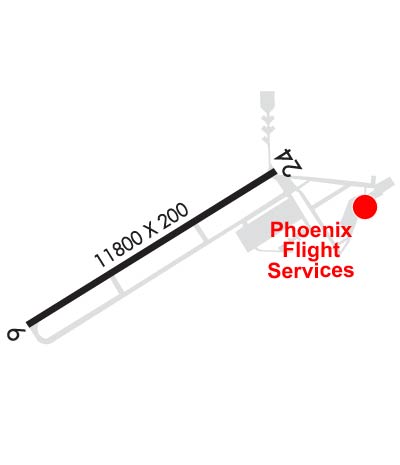
| Lat: N 4427.1 Long: W 08323.7 Elev: 633 Var: +07 Longest Runway: 11800 | ||
| AWOS: 118.7 CTAF: 123.0 | ||
| ||||||
| ||||||
|
| Rwy | Rwy | |||||||
| 11800x200 | 11800' | 11800x200 | 11800' | 108.50 - 245° | ||||
| Runway ID | Single Wheel | Double Wheel | Double Tandem Wheel | Dual Double Wheel |
| 07/25 | 155,000 | 330,000 | 550,000 | N/A |
| These numbers are Advisory and are not limits. The Airport Manager should have more accurate Weight Limits | ||||
 Airport Diagram might not be current. | |
| Facility Name: | OSCODA-WURTSMITH |
| City Name: | OSCODA |
| County: | IOSCO |
| State abbrev: | MI |
| State Name: | MICHIGAN |
| Ownership: | PUBLICLY OWNED |
| Use: | OPEN TO THE PUBLIC |
| Owner's Name: | OSCODA-WURTSMITH AIRPORT AUTH |
| Address: | 3961 E AIRPORT DR |
| OSCODA, MI 48750-2202 | |
| Owner's Phone: | 989-739-1111 |
| Manager's Name: | GARY KELLAN |
| Address: | 3961 E AIRPORT DR |
| OSCODA, MI 48750-2202 | |
| Phone: | 989-739-1111 |
| FAA Region: | GREAT LAKES |
| FAA Field Office: | DET |
| Date | Sunrise | Sunset |
|---|---|---|
| 09/24/21 Friday | 7:23 | 19:28 |
| 09/25/21 Saturday | 7:24 | 19:26 |
| 09/26/21 Sunday | 7:25 | 19:24 |
| 09/27/21 Monday | 7:26 | 19:22 |
| 09/28/21 Tuesday | 7:27 | 19:20 |
| 09/29/21 Wednesday | 7:29 | 19:18 |
| 09/30/21 Thursday | 7:30 | 19:17 |
| 10/01/21 Friday | 7:31 | 19:15 |
| 10/02/21 Saturday | 7:32 | 19:13 |
| 10/03/21 Sunday | 7:33 | 19:11 |
| 10/04/21 Monday | 7:35 | 19:09 |
| 10/05/21 Tuesday | 7:36 | 19:07 |
| 10/06/21 Wednesday | 7:37 | 19:06 |
| 10/07/21 Thursday | 7:38 | 19:04 |
| Airport Attendance Schedule | MON-FRI 0800-1700 |
| Airport Status | OPERATIONAL (This Status can change at any time - please check NOTAMS) |
| Airport Lighting Schedule | ACTVT HIRL, PAPI RWYS 07 & 25 & MALSR RWY 25 - CTAF. |
| Airport Storage Available | Tie Downs, Hanger |
| Extra Services Available | Flight Instruction, Aircraft Rental |
| Wind Indicator | YES - (lighted) |
| Control Tower | NO |
| CTAF Frequency | 123.000 |
| Unicom Frequency | 123.000 |
| Rotating Beacon Color | CLEAR-GREEN (Light Land Airport) |
| Segmented Circle | NO |
| Landing Fee |
| Airport Inspected | STATE - performed by STATE AERONAUTICAL PERSONNEL |
| Inspection Date | 03/27/2018 |
| Type of Fuel Available | Grade 100LL, JET A (freeze point -40C) |
| Airframe Repair Service | MAJOR |
| Power Plant Repair Service | MAJOR |
| Latitude | N4427.1 |
| Longitude | W08323.7 (ESTIMATED) |
| Arpt Elevation | 633ft (SURVEYED) |
| Magnetic Variation | 07W |
| 3 miles NW | of OSCODA |
| Traffic Pattern Altitude | |
| Sectional Chart | LAKE HURON |
| Operations (Reported) | Yearly | Avg. Daily |
|---|---|---|
| General Aviation Transient | 1843 | 5 |
| General Aviation Local | 3687 | 10 |
| Air Taxi | 0 | 0 |
| Commerical | 0 | 0 |
| Commuter | 0 | 0 |
| Military | 0 | 0 |
| Aircraft based on Field | |
|---|---|
| General Aviation Singles | 17 |
| General Aviation Multi | 0 |
| Jet Aircraft | 20 |
| General Aviation Helicopters | 1 |
| Military Aircraft | 0 |
| Gliders | 0 |
| Ultralights | 0 |
| FSS on field | NO |
| FSS tie-in | LANSING |
| FSS Phone | 1-800-WX-BRIEF |
| Who issues Notams | OSC |
| Notam D service at airport | YES |
| ARTCC Name | MINNEAPOLIS |
| Airport Certification | |
| Aircraft Rescue & Firefighting Index | None |
| Airport of Entry | No |
| Custom Landing Rights | No |
| Joint Civil/Military | No |
| Military Landing rights | YES |
| NATIONAL PLAN OF INTEGRATED AIRPORT SYSTEMS (NPIAS) |
| SEAGULLS & MIGRATORY BIRDS ON & INVOF ARPT. |
| TERMINAL BLDG & PKG LOT GATE ACCESS, DEPRESS V, THEN SIMULTANEOUS III-II, THEN I. |
| FOR CD CTC MINNEAPOLIS ARTCC AT 651-463-5588. |
| DURG DALGT HRS TAILWINDS MAY EXIST OVER APCH ENDS RWY 07 & 25 SIMULTANEOUSLY. |
| TRANSIENT ACFT FOLLOW BLUE CNTRLN ON TWY A AND TWY D TO LOCATE ARPT TERMINAL, FUEL & PARKING. |
| POTENTIAL JET BLAST ON TWY A INVOF RESTRICTED PARKING APRON AND EAST RAMP. |
| POSSIBLE SEVERE TURBULENCE OVER JET ENGINE TEST BUILDINGS (2). |
Airport Communications & Frequencies:
| |||||||||
| Runway: 07 | Runway: 25 | ||
| Mag heading: | 65° | Mag heading: | 245° |
| Rwy Slope: | -.11% Down | Rwy Slope: | .11% Up |
| Approach: | Approach: | LOC/GS | |
| Pattern: | Left Traffic | Pattern: | Left Traffic |
| Markings: | PRECISION INSTRUMENT | Markings: | PRECISION INSTRUMENT |
| Marking Condition: | FAIR | Marking Condition: | FAIR |
| Arresting Dev: | Arresting Dev: | ||
| Lat & Long: | N4426.6 W08324.8 | Lat. & Long.: | N4427.6 W08322.5 |
| Elev: | 632.8 ft. MSL | Elev: | 619.7 ft. MSL |
| TCH: | 75 ft. AGL | TCH: | 72 ft. AGL |
| Visual Glide Path: | 3.00 degrees | Visual Glide Path: | 3.00 degrees |
| Displaced Threshold: | No | Displaced Threshold: | No |
| Touchdown Zone: | YES | Touchdown Zone: | YES |
| Touchdown Elev.: | 633.1 feet | Touchdown Elev.: | 624.0 feet |
| Visual Glide Slope: | 4-Light PAPI on LEFT side of Runway | Visual Glide Slope: | 4-Light PAPI on LEFT side of Runway |
| RVR Equipment: | RVR Equipment: | ||
| RVV Equipment: | NO | RVV Equipment: | NO |
| Approach Lights: | Approach Lights: | MALSR - 1,400 foot medium intensity approach lighting system with runway alignment indicator lights | |
| REIL: | YES | REIL: | NO |
| Centerline Lights: | NO | Centerline Lights: | NO |
| Touchdown lights: | NO | Touchdown lights: | NO |
| Runway Category: | D | Runway Category: | Precision Instrument Runway |
| Declared Distances: | Declared Distances: | ||
| Obstructions: | TREE | Obstructions: | |
| Marked: | NOT Marked/Lighted | Marked: | |
| Clearance slope: | 34:1 | Clearance slope: | 50:1 |
| Obstruction height: | Obstruction height: | ||
| Dist. from runway: | Dist. from runway: | ||
| Centerline offset: | Centerline offset: | ||
| Comments: | Comments: |
Thanks for using FltPlan.com
all rights reserved © 1999-2021 by Flight Plan LLC
