| UNIV OF OKLA WESTHEIMER NORMAN OK |
| |
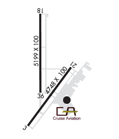
| Lat: N 3514.7 Long: W 09728.3 Elev: 1182 Var: -03 Longest Runway: 5199 | ||
| AWOS: 119.55 Ground: 121.6 Tower: 118.0 | ||
| ||||||||||||||||||||||||||||||||||||||||||||||||||||||||||||||||||||
| ||||||||||||||||||||||||||||||||||||||||||||||||||||||||||||||||||||
| ||||||||||||||||||||||||||||||||||||||||||||||||||||||||||||||||||||
| Rwy | Rwy | |||||||
| 4748x100 | 4748' | 111.10 - 033° | 4748x100 | 4748' | ||||
| 5199x100 | 5199' | 111.95 - 176° | 5199x100 | 5199' | ||||
| Runway ID | Single Wheel | Double Wheel | Double Tandem Wheel | Dual Double Wheel |
| 03/21 | 30,000 | 50,000 | 100,000 | N/A |
| 18/36 | 30,000 | 50,000 | 100,000 | N/A |
| These numbers are Advisory and are not limits. The Airport Manager should have more accurate Weight Limits | ||||
 Airport Diagram might not be current. | |
| Facility Name: | UNIVERSITY OF OKLAHOMA WESTHEIMER |
| City Name: | NORMAN |
| County: | CLEVELAND |
| State abbrev: | OK |
| State Name: | OKLAHOMA |
| Ownership: | PUBLICLY OWNED |
| Use: | OPEN TO THE PUBLIC |
| Owner's Name: | UNIV OF OKLAHOMA |
| Address: | 1700 LEXINGTON AVE |
| NORMAN, OK 73069 | |
| Owner's Phone: | 405-325-7233 |
| Manager's Name: | LANCE LAMKIN |
| Address: | 1700 LEXINGTON AVE, SUITE 212 |
| NORMAN, OK 73069 | |
| Phone: | 405-325-7233 |
| FAA Region: | SOUTHWEST |
| FAA Field Office: | AOK |
| Date | Sunrise | Sunset |
|---|---|---|
| 02/06/25 Thursday | 7:25 | 18:03 |
| 02/07/25 Friday | 7:24 | 18:04 |
| 02/08/25 Saturday | 7:23 | 18:05 |
| 02/09/25 Sunday | 7:23 | 18:06 |
| 02/10/25 Monday | 7:22 | 18:07 |
| 02/11/25 Tuesday | 7:21 | 18:08 |
| 02/12/25 Wednesday | 7:20 | 18:09 |
| 02/13/25 Thursday | 7:19 | 18:10 |
| 02/14/25 Friday | 7:18 | 18:11 |
| 02/15/25 Saturday | 7:16 | 18:12 |
| 02/16/25 Sunday | 7:15 | 18:13 |
| 02/17/25 Monday | 7:14 | 18:14 |
| 02/18/25 Tuesday | 7:13 | 18:15 |
| 02/19/25 Wednesday | 7:12 | 18:16 |
| Airport Attendance Schedule | 7 Days A Week 0600-2200 |
| Airport Status | OPERATIONAL (This Status can change at any time - please check NOTAMS) |
| Airport Lighting Schedule | WHEN ATCT CLSD ACTVT MIRL RYS 03/21 & 18/36; REIL RY 36;MALSR RY 18 & MALS RY 03 - CTAF. |
| Airport Storage Available | Tie Downs, Hanger |
| Extra Services Available | Avionics, Flight Instruction, Aircraft Rental |
| Wind Indicator | YES - (lighted) |
| Control Tower | YES |
| CTAF Frequency | 118.000 |
| Unicom Frequency | 122.950 |
| Rotating Beacon Color | WG |
| Segmented Circle | YES |
| Landing Fee | YES; SPL EVENT FEE FOR ALL ACFT THE DAY BEFORE AND DAY OF A UNIVERSITY HOME FOOTBALL GAME. |
| Airport Inspected | STATE - performed by STATE AERONAUTICAL PERSONNEL |
| Inspection Date | 08/08/2024 |
| Type of Fuel Available | Grade 100LL, JET A |
| Airframe Repair Service | MAJOR |
| Power Plant Repair Service | MAJOR |
| Latitude | N3514.7 |
| Longitude | W09728.3 (ESTIMATED) |
| Arpt Elevation | 1181ft (SURVEYED) |
| Magnetic Variation | 03E |
| 3 miles NW | of NORMAN |
| Traffic Pattern Altitude | |
| Sectional Chart | DALLAS-FT WORTH |
| Operations (Reported) | Yearly | Avg. Daily |
|---|---|---|
| General Aviation Transient | 0 | 0 |
| General Aviation Local | 0 | 0 |
| Air Taxi | 0 | 0 |
| Commerical | 0 | 0 |
| Commuter | 0 | 0 |
| Military | 0 | 0 |
| Aircraft based on Field | |
|---|---|
| General Aviation Singles | 0 |
| General Aviation Multi | 0 |
| Jet Aircraft | 0 |
| General Aviation Helicopters | 0 |
| Military Aircraft | 0 |
| Gliders | 0 |
| Ultralights | 0 |
| FSS on field | NO |
| FSS tie-in | MC ALESTER |
| FSS Phone | 1-800-WX-BRIEF |
| Who issues Notams | OUN |
| Notam D service at airport | YES |
| ARTCC Name | FORT WORTH |
| Airport Certification | |
| Aircraft Rescue & Firefighting Index | None |
| Airport of Entry | No |
| Custom Landing Rights | No |
| Joint Civil/Military | No |
| Military Landing rights | YES |
| NATIONAL PLAN OF INTEGRATED AIRPORT SYSTEMS (NPIAS) |
| GRANT AGREEMENTS UNDER FAAP/ADAP/AIP |
| SURPLUS PROPERTY AGREEMENT UNDER PUBLIC LAW 289 |
| ADVANCE PLANNING AGREEMENT UNDER FAAP |
| ASSURANCES PURSUANT TO TITLE VI, CIVIL RIGHTS ACT OF 1964 |
| THIS AIRPORT HAS BEEN SURVEYED BY THE NATIONAL GEODETIC SURVEY. |
| 180 DEG TURNS PROHIBITED ON RWYS FOR ALL OTHER THAN SINGLE ENGINE LIGHT ACFT. |
| CTN: COYOTES & BIRDS ON & INVOF OF RWYS. |
| HIGH DENSITY STUDENT OPNS INVOF ARPT & 5 MILES SOUTH. |
| TPA FOR HELS 500 FT AGL; SINGLE ENGINE 1000 FT AGL; MULTI-ENGINE & JETS 1500 FT AGL. |
| FOR CD IFUN TO CTC TWR, CTC OKE CITY APCH AT 405-681-5683. |
| PPR RQRD ALL TSNT ACFT DAY BFR & DAY OF UNIVERSITY HOME FOOTBALL GAME AT 405-360-3900. |
Airport Communications & Frequencies:
| ||||||||||||||||||
| Runway: 03 | Runway: 21 | ||
| Mag heading: | 33° | Mag heading: | 213° |
| Rwy Slope: | .08% Up | Rwy Slope: | -.08% Down |
| Approach: | LOC/DME | Approach: | |
| Pattern: | Left Traffic | Pattern: | Right Traffic |
| Markings: | NONPRECISION INSTRUMENT | Markings: | NONPRECISION INSTRUMENT |
| Marking Condition: | FAIR | Marking Condition: | FAIR |
| Arresting Dev: | Arresting Dev: | ||
| Lat & Long: | N3514.2 W09728.5 | Lat. & Long.: | N3514.8 W09728.0 |
| Elev: | 1175.2 ft. MSL | Elev: | 1179.1 ft. MSL |
| TCH: | 40 ft. AGL | TCH: | 40 ft. AGL |
| Visual Glide Path: | 3.00 degrees | Visual Glide Path: | 3.00 degrees |
| Displaced Threshold: | No | Displaced Threshold: | No |
| Touchdown Zone: | YES | Touchdown Zone: | YES |
| Touchdown Elev.: | 1177.4 feet | Touchdown Elev.: | 1179.2 feet |
| Visual Glide Slope: | 4-Light PAPI on LEFT side of Runway | Visual Glide Slope: | 4-Light PAPI on LEFT side of Runway |
| RVR Equipment: | RVR Equipment: | ||
| RVV Equipment: | NO | RVV Equipment: | NO |
| Approach Lights: | MALS - 1,400 foot medium intensity approach lighting system | Approach Lights: | |
| REIL: | NO | REIL: | NO |
| Centerline Lights: | NO | Centerline Lights: | NO |
| Touchdown lights: | NO | Touchdown lights: | NO |
| Runway Category: | D | Runway Category: | Runway with a Visual Approach |
| Declared Distances: | Declared Distances: |
| Runway: 18 | Runway: 36 | ||
| Mag heading: | 177° | Mag heading: | 357° |
| Rwy Slope: | -.08% Down | Rwy Slope: | .08% Up |
| Approach: | ILS/DME | Approach: | |
| Pattern: | Right Traffic | Pattern: | Left Traffic |
| Markings: | PRECISION INSTRUMENT | Markings: | NONPRECISION INSTRUMENT |
| Marking Condition: | GOOD | Marking Condition: | GOOD |
| Arresting Dev: | Arresting Dev: | ||
| Lat & Long: | N3515.4 W09728.4 | Lat. & Long.: | N3514.5 W09728.4 |
| Elev: | 1181.6 ft. MSL | Elev: | 1177.2 ft. MSL |
| TCH: | 55 ft. AGL | TCH: | 40 ft. AGL |
| Visual Glide Path: | 3.00 degrees | Visual Glide Path: | 3.00 degrees |
| Displaced Threshold: | No | Displaced Threshold: | No |
| Touchdown Zone: | YES | Touchdown Zone: | YES |
| Touchdown Elev.: | 1181.7 feet | Touchdown Elev.: | 1181.6 feet |
| Visual Glide Slope: | 4-Light PAPI on LEFT side of Runway | Visual Glide Slope: | 4-Light PAPI on LEFT side of Runway |
| RVR Equipment: | RVR Equipment: | ||
| RVV Equipment: | NO | RVV Equipment: | NO |
| Approach Lights: | MALSR - 1,400 foot medium intensity approach lighting system with runway alignment indicator lights | Approach Lights: | |
| REIL: | NO | REIL: | YES |
| Centerline Lights: | NO | Centerline Lights: | NO |
| Touchdown lights: | NO | Touchdown lights: | NO |
| Runway Category: | Precision Instrument Runway | Runway Category: | Runway with a Non-precision Approach having visibility minimums greater than 3/4 mile |
| Declared Distances: | Declared Distances: |
Thanks for using FltPlan.com
all rights reserved © 1999-2025 by Flight Plan LLC