
| CENTRAL MAINE ARPT OF NORRIDGE NORRIDGEWOCK ME |
| |
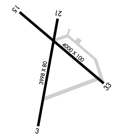
| Lat: N 4442.9 Long: W 06952.0 Elev: 270 Var: +18 Longest Runway: 4000 | ||
| AWOS: 122.8 CTAF: 122.8 | ||
| ||||||
| ||||||
|
| Rwy | Rwy | |||||||
| 3998x80 | 3998' | 3998x80 | 3998' | |||||
| 4000x100 | 4000' | 4000x100 | 4000' | |||||
| Runway ID | Single Wheel | Double Wheel | Double Tandem Wheel | Dual Double Wheel |
| 03/21 | 30,000 | 60,000 | N/A | N/A |
| 15/33 | 30,000 | 60,000 | N/A | N/A |
| These numbers are Advisory and are not limits. The Airport Manager should have more accurate Weight Limits | ||||
 Airport Diagram might not be current. | |
| Facility Name: | CENTRAL MAINE /NORRIDGEWOCK |
| City Name: | NORRIDGEWOCK |
| County: | SOMERSET |
| State abbrev: | ME |
| State Name: | MAINE |
| Ownership: | PUBLICLY OWNED |
| Use: | OPEN TO THE PUBLIC |
| Owner's Name: | TOWN OF NORRIDGEWOCK |
| Address: | P.O. BOX 7 |
| NORRIDGEWOCK, ME 04957 | |
| Owner's Phone: | 207-634-2252 |
| Manager's Name: | RICHARD LABELLE |
| Address: | P.O. BOX 7; ARPT ADS: 603 AIRPORT RD. |
| NORRIDGEWOCK, ME 04957 | |
| Phone: | 207-634-2252; ADDNL CTC: ROLAND RAY, 207-212-3191. |
| FAA Region: | NEW ENGLAND |
| FAA Field Office: | NONE |
| Date | Sunrise | Sunset |
|---|---|---|
| 09/24/21 Friday | 6:29 | 18:34 |
| 09/25/21 Saturday | 6:30 | 18:32 |
| 09/26/21 Sunday | 6:31 | 18:30 |
| 09/27/21 Monday | 6:32 | 18:28 |
| 09/28/21 Tuesday | 6:33 | 18:26 |
| 09/29/21 Wednesday | 6:35 | 18:24 |
| 09/30/21 Thursday | 6:36 | 18:22 |
| 10/01/21 Friday | 6:37 | 18:21 |
| 10/02/21 Saturday | 6:38 | 18:19 |
| 10/03/21 Sunday | 6:39 | 18:17 |
| 10/04/21 Monday | 6:41 | 18:15 |
| 10/05/21 Tuesday | 6:42 | 18:13 |
| 10/06/21 Wednesday | 6:43 | 18:11 |
| 10/07/21 Thursday | 6:44 | 18:10 |
| Airport Attendance Schedule | MON, THUR, SAT 0700-1500, SUN TUE WED FRI UNATTENDED |
| Airport Status | OPERATIONAL (This Status can change at any time - please check NOTAMS) |
| Airport Lighting Schedule | ACTVT REIL RWY 15 & 33; PAPI RWY 15; MIRL RWY 15/33 - CTAF. |
| Airport Storage Available | Tie Downs |
| Extra Services Available | Flight Instruction, Aircraft Rental, Annual Surveying |
| Wind Indicator | YES - (lighted) |
| Control Tower | NO |
| CTAF Frequency | 122.800 |
| Unicom Frequency | 122.800 |
| Rotating Beacon Color | CLEAR-GREEN (Light Land Airport) |
| Segmented Circle | YES |
| Landing Fee | NO |
| Airport Inspected | STATE - performed by PRIVATE CONTRACT PERSONNEL |
| Inspection Date | 08/07/2019 |
| Type of Fuel Available | Grade 100LLMOGAS; -1024 HR FUEL AVBL WITH MAJOR CREDIT CARD. |
| Airframe Repair Service | MAJOR |
| Power Plant Repair Service | MAJOR |
| Latitude | N4442.9 |
| Longitude | W06952.0 (ESTIMATED) |
| Arpt Elevation | 270ft (SURVEYED) |
| Magnetic Variation | 18W |
| 4 miles W | of NORRIDGEWOCK |
| Traffic Pattern Altitude | |
| Sectional Chart | MONTREAL |
| Operations (Reported) | Yearly | Avg. Daily |
|---|---|---|
| General Aviation Transient | 2900 | 8 |
| General Aviation Local | 6900 | 19 |
| Air Taxi | 0 | 0 |
| Commerical | 0 | 0 |
| Commuter | 0 | 0 |
| Military | 20 | 0 |
| Aircraft based on Field | |
|---|---|
| General Aviation Singles | 27 |
| General Aviation Multi | 0 |
| Jet Aircraft | 0 |
| General Aviation Helicopters | 0 |
| Military Aircraft | 0 |
| Gliders | 0 |
| Ultralights | 1 |
| FSS on field | NO |
| FSS tie-in | BANGOR |
| FSS Phone | 1-800-WX-BRIEF |
| Who issues Notams | BGR |
| Notam D service at airport | YES |
| ARTCC Name | BOSTON |
| Airport Certification | |
| Aircraft Rescue & Firefighting Index | None |
| Airport of Entry | No |
| Custom Landing Rights | No |
| Joint Civil/Military | No |
| Military Landing rights | YES |
| NATIONAL PLAN OF INTEGRATED AIRPORT SYSTEMS (NPIAS) |
| GRANT AGREEMENTS UNDER FAAP/ADAP/AIP |
| AGREEMENT UNDER DLAND OR DCLA HAS EXPIRED. |
| BIRDS AND DEER ON & INVOF ARPT. |
| RWY 21 HAS 30 FT DROPOFF 100 FT FM EOR. |
| FOR CD CTC PORTLAND APCH AT 207-874-7320. WHEN PORTLAND APCH CLSD, CTC BOSTON ARTCC AT 603-879-6859. |
Airport Communications & Frequencies:
| |||||||||||||||||
| Runway: 03 | Runway: 21 | ||
| Mag heading: | 28° | Mag heading: | 208° |
| Rwy Slope: | .03% Up | Rwy Slope: | -.03% Down |
| Approach: | Approach: | ||
| Pattern: | Left Traffic | Pattern: | Left Traffic |
| Markings: | NONPRECISION INSTRUMENT | Markings: | BASIC |
| Marking Condition: | POOR; MARKINGS FADED, CNTRLN MISG. | Marking Condition: | POOR; MARKINGS FADED, CNTRLN MISG. |
| Arresting Dev: | Arresting Dev: | ||
| Lat & Long: | N4442.5 W06952.1 | Lat. & Long.: | N4443.2 W06952.0 |
| Elev: | 265.0 ft. MSL | Elev: | 266.2 ft. MSL |
| TCH: | TCH: | ||
| Visual Glide Path: | Visual Glide Path: | ||
| Displaced Threshold: | No | Displaced Threshold: | No |
| Touchdown Zone: | YES | Touchdown Zone: | YES |
| Touchdown Elev.: | 268.3 feet | Touchdown Elev.: | 270.2 feet |
| Visual Glide Slope: | Visual Glide Slope: | ||
| RVR Equipment: | RVR Equipment: | ||
| RVV Equipment: | NO | RVV Equipment: | NO |
| Approach Lights: | Approach Lights: | ||
| REIL: | NO | REIL: | NO |
| Centerline Lights: | NO | Centerline Lights: | NO |
| Touchdown lights: | NO | Touchdown lights: | NO |
| Runway Category: | Runway with a Non-precision Approach | Runway Category: | Runway with a Visual Approach |
| Declared Distances: | Declared Distances: | ||
| Obstructions: | TREES | Obstructions: | TREES |
| Marked: | NOT Marked/Lighted | Marked: | NOT Marked/Lighted |
| Clearance slope: | Clearance slope: | 13:1 | |
| Obstruction height: | 35 feet AGL | Obstruction height: | 69 feet AGL |
| Dist. from runway: | 201 feet | Dist. from runway: | 1108 feet |
| Centerline offset: | 225 left of centerline | Centerline offset: | 166 feet left of centerline |
| Comments: | +35 FT TREES 0 FT - 25 FT FM THR, 240 FT - 250 FT RIGHT OF CNTRLN, +40 FT TREES O FT - 70 FT FM THR, 240 FT - 250 FT LEFT OF CNTRLN. | Comments: | +4 FT - 12 FT BRUSH 105 FT - 150 FT FM THR, 125 FT LEFT AND RIGHT OF CNTRLN. |
| Runway: 15 | Runway: 33 | ||
| Mag heading: | 148° | Mag heading: | 328° |
| Rwy Slope: | -.15% Down | Rwy Slope: | .15% Up |
| Approach: | Approach: | ||
| Pattern: | Left Traffic | Pattern: | Left Traffic |
| Markings: | NONPRECISION INSTRUMENT | Markings: | BASIC |
| Marking Condition: | FAIR | Marking Condition: | FAIR |
| Arresting Dev: | Arresting Dev: | ||
| Lat & Long: | N4443.2 W06952.3 | Lat. & Long.: | N4442.8 W06951.6 |
| Elev: | 264.1 ft. MSL | Elev: | 258.3 ft. MSL |
| TCH: | 43 ft. AGL | TCH: | |
| Visual Glide Path: | 3.00 degrees | Visual Glide Path: | |
| Displaced Threshold: | No | Displaced Threshold: | No |
| Touchdown Zone: | YES | Touchdown Zone: | YES |
| Touchdown Elev.: | 269.7 feet | Touchdown Elev.: | 269.7 feet |
| Visual Glide Slope: | 2-Light PAPI on LEFT side of Runway | Visual Glide Slope: | |
| RVR Equipment: | RVR Equipment: | ||
| RVV Equipment: | NO | RVV Equipment: | NO |
| Approach Lights: | Approach Lights: | ||
| REIL: | YES | REIL: | YES |
| Centerline Lights: | NO | Centerline Lights: | NO |
| Touchdown lights: | NO | Touchdown lights: | NO |
| Runway Category: | Runway with a Non-precision Approach | Runway Category: | Runway with a Visual Approach |
| Declared Distances: | Declared Distances: | ||
| Obstructions: | Unknown | Obstructions: | TREES |
| Marked: | NOT Marked/Lighted | Marked: | NOT Marked/Lighted |
| Clearance slope: | 18:1 | Clearance slope: | 13:1 |
| Obstruction height: | 22 feet AGL | Obstruction height: | 27 feet AGL |
| Dist. from runway: | 580 feet | Dist. from runway: | 563 feet |
| Centerline offset: | 283 right of centerline | Centerline offset: | 109 feet right of centerline |
| Comments: | +10 FT - +12 FT TREES 100 FT FM THR, 120 FT RIGHT OF CNTRLN. | Comments: |
Thanks for using FltPlan.com
all rights reserved © 1999-2021 by Flight Plan LLC
