
| WATERBURY-OXFORD OXFORD CT |
| |
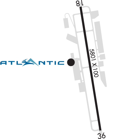
| Lat: N 4128.7 Long: W 07308.1 Elev: 730 Var: +14 Longest Runway: 5801 | ||
| Clr Del: 121.65/135.1 Dept. ATIS: 132.97 Arr. ATIS: 132.97 AWOS: 132.97 Ground: 121.65 Tower: 118.47 | ||
| ||||||||||||||||||||||||||||||||||||||||||||||||||||||||||||||
| ||||||||||||||||||||||||||||||||||||||||||||||||||||||||||||||
| ||||||||||||||||||||||||||||||||||||||||||||||||||||||||||||||
| Rwy | Rwy | |||||||
| 5801x100 | 5801' | 5801x100 | 5301' | 109.55 - 004° | ||||
| Runway ID | Single Wheel | Double Wheel | Double Tandem Wheel | Dual Double Wheel |
| 18/36 | 50,000 | 85,000 | 145,000 | N/A |
| These numbers are Advisory and are not limits. The Airport Manager should have more accurate Weight Limits | ||||
 Airport Diagram might not be current. | |
| Facility Name: | WATERBURY-OXFORD |
| City Name: | OXFORD |
| County: | NEW HAVEN |
| State abbrev: | CT |
| State Name: | CONNECTICUT |
| Ownership: | PUBLICLY OWNED |
| Use: | OPEN TO THE PUBLIC |
| Owner's Name: | CONNECTICUT AIRPORT AUTHORITY |
| Address: | SUITE 160, 334 ELLA GRASSO TURNPIKE |
| WINDSOR LOCKS, CT 06096 | |
| Owner's Phone: | 860-292-2000 |
| Manager's Name: | MATTHEW J. KELLY |
| Address: | 300 CHRISTIAN ST |
| OXFORD, CT 06478 | |
| Phone: | 203-264-8010 |
| FAA Region: | NEW ENGLAND |
| FAA Field Office: | NONE |
| Date | Sunrise | Sunset |
|---|---|---|
| 09/24/21 Friday | 6:42 | 18:47 |
| 09/25/21 Saturday | 6:43 | 18:45 |
| 09/26/21 Sunday | 6:44 | 18:43 |
| 09/27/21 Monday | 6:45 | 18:42 |
| 09/28/21 Tuesday | 6:46 | 18:40 |
| 09/29/21 Wednesday | 6:47 | 18:38 |
| 09/30/21 Thursday | 6:48 | 18:36 |
| 10/01/21 Friday | 6:49 | 18:35 |
| 10/02/21 Saturday | 6:50 | 18:33 |
| 10/03/21 Sunday | 6:51 | 18:31 |
| 10/04/21 Monday | 6:52 | 18:30 |
| 10/05/21 Tuesday | 6:53 | 18:28 |
| 10/06/21 Wednesday | 6:54 | 18:26 |
| 10/07/21 Thursday | 6:55 | 18:25 |
| Airport Attendance Schedule | CONTINUOUS |
| Airport Status | OPERATIONAL (This Status can change at any time - please check NOTAMS) |
| Airport Lighting Schedule | ACTVT REIL RWY 36; PAPI RWYS 18 & 36; HIRL RWY 18/36 - CTAF. |
| Airport Storage Available | Tie Downs, Hanger |
| Extra Services Available | Avionics, Charter, Flight Instruction, Aircraft Rental, Aircraft Sales |
| Wind Indicator | YES - (lighted) |
| Control Tower | YES |
| CTAF Frequency | 118.475 |
| Unicom Frequency | 122.950 |
| Rotating Beacon Color | CLEAR-GREEN (Light Land Airport) |
| Segmented Circle | YES |
| Landing Fee | NO; LDG FEE FOR BUS/CORPORATE & REVENUE PRODUCING ACFT. |
| Airport Inspected | STATE - performed by STATE AERONAUTICAL PERSONNEL |
| Inspection Date | 11/09/2020 |
| Type of Fuel Available | Grade 100LL, JET A (freeze point -40C) |
| Airframe Repair Service | MAJOR |
| Power Plant Repair Service | MAJOR |
| Latitude | N4128.7 |
| Longitude | W07308.1 (ESTIMATED) |
| Arpt Elevation | 730ft (SURVEYED) |
| Magnetic Variation | 14W |
| 3 miles N | of OXFORD |
| Traffic Pattern Altitude | 973 FT AGL ACFT UP TO 12500 LBS; 1473 FT AGL ACFT OVR 12500 LBS. |
| Sectional Chart | NEW YORK |
| Operations (Reported) | Yearly | Avg. Daily |
|---|---|---|
| General Aviation Transient | 16289 | 45 |
| General Aviation Local | 12078 | 33 |
| Air Taxi | 3126 | 9 |
| Commerical | 0 | 0 |
| Commuter | 0 | 0 |
| Military | 1171 | 3 |
| Aircraft based on Field | |
|---|---|
| General Aviation Singles | 111 |
| General Aviation Multi | 11 |
| Jet Aircraft | 32 |
| General Aviation Helicopters | 3 |
| Military Aircraft | 0 |
| Gliders | 0 |
| Ultralights | 0 |
| FSS on field | NO |
| FSS tie-in | BRIDGEPORT |
| FSS Phone | 1-800-WX-BRIEF |
| Who issues Notams | OXC |
| Notam D service at airport | YES |
| ARTCC Name | BOSTON |
| Airport Certification | |
| Aircraft Rescue & Firefighting Index | None |
| Airport of Entry | No |
| Custom Landing Rights | No |
| Joint Civil/Military | No |
| Military Landing rights | YES |
| NATIONAL PLAN OF INTEGRATED AIRPORT SYSTEMS (NPIAS) |
| GRANT AGREEMENTS UNDER FAAP/ADAP/AIP |
| ASSURANCES PURSUANT TO TITLE VI, CIVIL RIGHTS ACT OF 1964 |
| TGLS AND PLAS PROHIBITED 2300-0700. |
| (E94) SAWRS. |
| TWY B, SOUTH OF TWY G, REFLECTORS ONLY. |
| TWY D, REFLECTORS ONLY. |
| FOR CD WHEN TWR CLSD CTC NEW YORK APCH AT 516-683-2449. |
| STEEP DROP OFF AFT SAFETY AREA NORTH & SOUTH OF TWY A. |
| PLA RWY 36 NA WHEN RWY 18 ACTV. |
| ARPT CLSD TO ACR OPNS. |
| PAEW VCNTY RWY 18/36 SAFETY ZONE SUMMER ONLY SR-SS (MOWING IN PROG DLY). |
| RWY 36 CALM WIND RWY. |
| 748 FT ELEC TRANSMISSION TWRS RUNNING NE TO SW 0.2 MI N OF MID MKR. |
| DEER & BIRDS ON & INVOF ARPT. |
| ALL SOD AREAS CLSD. |
Airport Communications & Frequencies:
| ||||||||||||||||||||||||||||
| Runway: 18 | Runway: 36 | ||
| Mag heading: | 185° | Mag heading: | 5° |
| Rwy Slope: | -.86% Down | Rwy Slope: | .86% Up |
| Approach: | Approach: | ILS/DME | |
| Pattern: | Right Traffic | Pattern: | Left Traffic |
| Markings: | PRECISION INSTRUMENT | Markings: | PRECISION INSTRUMENT |
| Marking Condition: | GOOD | Marking Condition: | GOOD |
| Arresting Dev: | Arresting Dev: | ||
| Lat & Long: | N4129.2 W07308.2 | Lat. & Long.: | N4128.2 W07308.0 |
| Elev: | 730.1 ft. MSL | Elev: | 680.1 ft. MSL |
| TCH: | 47 ft. AGL | TCH: | 56 ft. AGL |
| Visual Glide Path: | 3.00 degrees | Visual Glide Path: | 3.00 degrees |
| Displaced Threshold: | No | Displaced Threshold: | 500 feet |
| Touchdown Zone: | YES | Touchdown Zone: | YES |
| Touchdown Elev.: | 730.1 feet | Touchdown Elev.: | 720.6 feet |
| Visual Glide Slope: | 4-Light PAPI on LEFT side of Runway; LGTS BAFFLED BYD 6 DEGS LEFT OF CNTRLN. | Visual Glide Slope: | 4-Light PAPI on LEFT side of Runway; LGTS BAFFLED DUE TO TREES AND PWR LN TWR BYD 5 DEGS RIGHT OF CNTRLN. |
| RVR Equipment: | RVR Equipment: | ||
| RVV Equipment: | NO | RVV Equipment: | NO |
| Approach Lights: | Approach Lights: | ||
| REIL: | NO | REIL: | YES |
| Centerline Lights: | NO | Centerline Lights: | NO |
| Touchdown lights: | NO | Touchdown lights: | NO |
| Runway Category: | Precision Instrument Runway | Runway Category: | Precision Instrument Runway |
| Declared Distances: | TORA:5801' TODA:5801' ASDA:5801' LDA:5801' | Declared Distances: | TORA:5801' TODA:5801' ASDA:5801' LDA:5301' |
| Obstructions: | Obstructions: | PLINE | |
| Marked: | Marked: | LIGHTED | |
| Clearance slope: | 39:1 | Clearance slope: | 16:1 |
| Obstruction height: | Obstruction height: | 50 feet AGL | |
| Dist. from runway: | 1300 feet | Dist. from runway: | 1000 feet |
| Centerline offset: | Centerline offset: | 600 feet right of centerline; PWR LN RUNS DGNLY ACRS THE APCH. | |
| Comments: | Comments: |
Thanks for using FltPlan.com
all rights reserved © 1999-2021 by Flight Plan LLC


