
| KETCHIKAN INTL KETCHIKAN AK |
| |
| Lat: N 5521.2 Long: W 13142.7 Elev: 92 Var: -21 Longest Runway: 7500 | ||
| CTAF: 123.6 | ||
| ||||||||||||||||||||||||||||||||||||||||||||||||||||||||||||||||||||
| ||||||||||||||||||||||||||||||||||||||||||||||||||||||||||||||||||||
| ||||||||||||||||||||||||||||||||||||||||||||||||||||||||||||||||||||
| ||||||||||||||||||||||||||||||||||||||||||||||||||||||||||||||||||||
| ||||||||||||||||||||||||||||||||||||||||||||||||||||||||||||||||||||
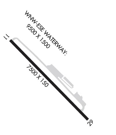
| Rwy | Rwy | |||||||
| 7500x150 | 7500' | 109.30 - 114° | 7500x150 | 7500' | ||||
| 9500x1500 | 9500' | 9500x1500 | 9500' | |||||
| Runway ID | Single Wheel | Double Wheel | Double Tandem Wheel | Dual Double Wheel |
| 11/29 | 120,000 | 207,000 | 350,000 | N/A |
| WNW/ESE | N/A | N/A | N/A | N/A |
| These numbers are Advisory and are not limits. The Airport Manager should have more accurate Weight Limits | ||||
 Airport Diagram might not be current. | |
| Facility Name: | KETCHIKAN INTL |
| City Name: | KETCHIKAN |
| County: | KETCHIKAN GATEWAY |
| State abbrev: | AK |
| State Name: | ALASKA |
| Ownership: | PUBLICLY OWNED |
| Use: | OPEN TO THE PUBLIC |
| Owner's Name: | ALASKA DOT&PF SOUTHCOAST REGION |
| Address: | 6860 GLACIER HIGHWAY |
| JUNEAU, AK 99801-7999 | |
| Owner's Phone: | 907-465-1786 |
| Manager's Name: | ALEX PUERA; ALEX PEURA |
| Address: | 1000 ARPT TERMINAL WAY |
| KETCHIKAN, AK 99901 | |
| Phone: | 907-225-6800 |
| FAA Region: | ALASKA |
| FAA Field Office: | NONE |
| Date | Sunrise | Sunset |
|---|---|---|
| 03/13/25 Thursday | 7:07 | 18:47 |
| 03/14/25 Friday | 7:05 | 18:49 |
| 03/15/25 Saturday | 7:02 | 18:51 |
| 03/16/25 Sunday | 7:00 | 18:53 |
| 03/17/25 Monday | 6:57 | 18:55 |
| 03/18/25 Tuesday | 6:54 | 18:57 |
| 03/19/25 Wednesday | 6:52 | 18:59 |
| 03/20/25 Thursday | 6:49 | 19:01 |
| 03/21/25 Friday | 6:47 | 19:03 |
| 03/22/25 Saturday | 6:44 | 19:05 |
| 03/23/25 Sunday | 6:42 | 19:07 |
| 03/24/25 Monday | 6:39 | 19:09 |
| 03/25/25 Tuesday | 6:36 | 19:10 |
| 03/26/25 Wednesday | 6:34 | 19:12 |
| Airport Attendance Schedule | 7 Days A Week 0600-2130 |
| Airport Status | OPERATIONAL (This Status can change at any time - please check NOTAMS) |
| Airport Lighting Schedule | WHEN KTN FSS CLSD ACTVT MALSR RWY 11 & 29; HIRL RWY 11/29 - CTAF. PAPI RWY 11 & 29 ON CONSLY.; WHEN KTN FSS CLSD ON CONSLY. |
| Airport Storage Available | Tie Downs, Hanger |
| Extra Services Available | Beaching Gear, Cargo Handling |
| Wind Indicator | YES - (lighted) |
| Control Tower | NO |
| CTAF Frequency | 123.600 |
| Unicom Frequency | |
| Rotating Beacon Color | WG |
| Segmented Circle | YES |
| Landing Fee | YES; LNDG FEE FOR GA ACFT UNDER 6000 LB & FLOAT PLANE USE OF SPB FLOAT. |
| Airport Inspected | FEDERAL - performed by FAA AIRPORTS FIELD PERSONNEL |
| Inspection Date | 02/15/2024 |
| Type of Fuel Available | Grade 100LL, JET A (freeze point -40C); -10FUEL AVBL SUMMER 0530-1930; WINTER 0630-2030 VIA 122.95 OR PH: 907-531-9891. |
| Airframe Repair Service | None |
| Power Plant Repair Service | None |
| Latitude | N5521.2 |
| Longitude | W13142.7 (ESTIMATED) |
| Arpt Elevation | 92ft (SURVEYED) |
| Magnetic Variation | 21E |
| 1 miles W | of KETCHIKAN |
| Traffic Pattern Altitude | |
| Sectional Chart | KETCHIKAN |
| Operations (Reported) | Yearly | Avg. Daily |
|---|---|---|
| General Aviation Transient | 0 | 0 |
| General Aviation Local | 0 | 0 |
| Air Taxi | 0 | 0 |
| Commerical | 0 | 0 |
| Commuter | 0 | 0 |
| Military | 0 | 0 |
| Aircraft based on Field | |
|---|---|
| General Aviation Singles | 0 |
| General Aviation Multi | 0 |
| Jet Aircraft | 0 |
| General Aviation Helicopters | 0 |
| Military Aircraft | 0 |
| Gliders | 0 |
| Ultralights | 0 |
| FSS on field | YES |
| FSS tie-in | KETCHIKAN |
| FSS Phone | 225-9481 (Local call) |
| Nearby FSS | JUNEAU |
| Phone | 1-800-866-297-2236 |
| Who issues Notams | KTN |
| Notam D service at airport | YES |
| ARTCC Name | ANCHORAGE |
| Airport Certification | AIRPORT RECEIVING SCHEDULED AIR CARRIER SERVICE FROM CARRIERS CERTIFICATED BY THE CIVIL AERONAUTICS BOARD; ACR OPS MORE THAN 30 PAX NA IN EXCESS OF 15 MIN BFR OR AFT SKED ARR OR DEP WO PPR WITH AMGR & CFM ARFF SVC AVBL BFR LDG OR TKOF. |
| Aircraft Rescue & Firefighting Index | AIRPORT HAS A CERTIFICATE UNDER CFR PART 139 |
| Airport of Entry | No |
| Custom Landing Rights | YES |
| Joint Civil/Military | No |
| Military Landing rights | YES |
| NATIONAL PLAN OF INTEGRATED AIRPORT SYSTEMS (NPIAS) |
| GRANT AGREEMENTS UNDER FAAP/ADAP/AIP |
| ASSURANCES PURSUANT TO TITLE VI, CIVIL RIGHTS ACT OF 1964 |
| TRRN CAUSES TURB ON ARR & DEP ROUTES. |
| USCG HELI 55-21-27.6N/131-42-19.8W; INVOF KETCHIKAN INTL ARPT & SEAPLAN BASE; MED-VAC MISSIONS ONLY - POC COMMANDER CG DISTRICT 17, 709 W 9TH ST, RM 661. BOX 25517 JUNEAU, AK 99802 - 907-463-2247/2000. |
| WX CAMERAS AVBL ON INTERNET AT HTTPS://WEATHERCAMS.FAA.GOV |
| TWY C LGTS OTS INDEF. |
| PPR FOR LDG DURG UNATNDD HRS - FBO 907-531-9891 FOR ARNGMT & CALL OUT CHARGE. |
| ALERT: SPL ATC RULES PART 93 & STD VFR ARR & DEP PROC & PAT INFO - SEE REG NOTICE. |
| GA APRON; TWY C; NE SECTION OF MAIN APRON PCN 21/F/B/X/T. |
| DOCK W OF ARPT CLSD NOV 1 - APR 1; PPR OVNGT - AMGR; FERRY BTW ARPT & CITY OPR CONSLY WHEN ARPT ATNDD. |
| BIRDS ON & INVOF ARPT. |
| PRIOR TO OPS ON APRON/TWY ALL ACFT CTC KTN FSS & ADZ INTNS. |
| SFC COND RPRTS REFLECT CONDS WHILE ARPT ATNDD ONLY. |
| CTN AIR TAXI & BOATS IN HARBOR; FLOATING DEBRIS PSBL. |
| SNOW & ICE REMOVAL NA WHEN ARPT UNATTND. |
| RWY 11/2 9 SAND USED TO ENHANCE FRICTION MAY NOT MEET FAA SPECS. |
| RWY 11/2 9 PCR VALUE: 510/F/B/X/T |
Airport Communications & Frequencies:
| |||||||
| Runway: 11 | Runway: 29 | ||
| Mag heading: | 115° | Mag heading: | 295° |
| Rwy Slope: | .06% Up | Rwy Slope: | -.06% Down |
| Approach: | ILS/DME | Approach: | |
| Pattern: | Right Traffic; WX PMTG FOR LIGHT SINGLE/TWIN ENG. | Pattern: | Left Traffic |
| Markings: | PRECISION INSTRUMENT | Markings: | PRECISION INSTRUMENT |
| Marking Condition: | GOOD | Marking Condition: | GOOD |
| Arresting Dev: | Arresting Dev: | ||
| Lat & Long: | N5521.7 W13143.4 | Lat. & Long.: | N5520.8 W13141.9 |
| Elev: | 84.9 ft. MSL | Elev: | 89.2 ft. MSL |
| TCH: | 50 ft. AGL | TCH: | 49 ft. AGL |
| Visual Glide Path: | 3.00 degrees | Visual Glide Path: | 3.00 degrees |
| Displaced Threshold: | No | Displaced Threshold: | No |
| Touchdown Zone: | YES | Touchdown Zone: | YES |
| Touchdown Elev.: | 91.8 feet | Touchdown Elev.: | 92.3 feet |
| Visual Glide Slope: | 4-Light PAPI on LEFT side of Runway; PAPI UNUSBL 5 DEGS LEFT AND RIGHT OF CNTRLN. | Visual Glide Slope: | 4-Light PAPI on LEFT side of Runway; PAPI UNUSBL BYD 6 NM. |
| RVR Equipment: | TOUCHDOWN-ROLLOUT | RVR Equipment: | TOUCHDOWN-ROLLOUT |
| RVV Equipment: | NO | RVV Equipment: | NO |
| Approach Lights: | MALSR - 1,400 foot medium intensity approach lighting system with runway alignment indicator lights | Approach Lights: | MALSR - 1,400 foot medium intensity approach lighting system with runway alignment indicator lights |
| REIL: | NO | REIL: | NO |
| Centerline Lights: | NO | Centerline Lights: | NO |
| Touchdown lights: | NO | Touchdown lights: | NO |
| Runway Category: | Precision Instrument Runway | Runway Category: | Runway with a Non-precision Approach having visibility minimums greater than 3/4 mile |
| Declared Distances: | Declared Distances: | ||
| Obstructions: | TREES | Obstructions: | |
| Marked: | NOT Marked/Lighted | Marked: | |
| Clearance slope: | 50:1 | Clearance slope: | 34:1 |
| Obstruction height: | 103 feet AGL | Obstruction height: | |
| Dist. from runway: | 3300 feet | Dist. from runway: | |
| Centerline offset: | Centerline offset: | ||
| Comments: | Comments: |
| Runway: ESE | Runway: WNW | ||
| Mag heading: | N/A | Mag heading: | N/A |
| Approach: | Approach: | ||
| Pattern: | Left Traffic | Pattern: | Left Traffic |
| Markings: | Markings: | ||
| Marking Condition: | Marking Condition: | ||
| Arresting Dev: | Arresting Dev: | ||
| Lat & Long: | Lat. & Long.: | ||
| Elev: | N/A | Elev: | N/A |
| TCH: | TCH: | ||
| Visual Glide Path: | Visual Glide Path: | ||
| Displaced Threshold: | No | Displaced Threshold: | No |
| Touchdown Zone: | NO | Touchdown Zone: | NO |
| Touchdown Elev.: | Touchdown Elev.: | ||
| Visual Glide Slope: | Visual Glide Slope: | ||
| RVR Equipment: | RVR Equipment: | ||
| RVV Equipment: | NO | RVV Equipment: | NO |
| Approach Lights: | Approach Lights: | ||
| REIL: | NO | REIL: | NO |
| Centerline Lights: | NO | Centerline Lights: | NO |
| Touchdown lights: | NO | Touchdown lights: | NO |
| Runway Category: | Runway with a Visual Approach | Runway Category: | Runway with a Visual Approach |
| Declared Distances: | Declared Distances: |
Thanks for using FltPlan.com
all rights reserved © 1999-2025 by Flight Plan LLC


