
| PLEASANTON MUNI PLEASANTON TX |
| |
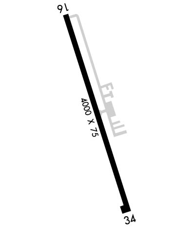
| Lat: N 2857.3 Long: W 09831.2 Elev: 430 Var: -06 Longest Runway: 4000 | ||
| Clr Del: 121.375 AWOS: 118.57 CTAF: 122.7 | ||
| ||||||||||||||||||||||||||||||||||||||||||||
| ||||||||||||||||||||||||||||||||||||||||||||
| ||||||||||||||||||||||||||||||||||||||||||||
| Rwy | Rwy | |||||||
| 4000x75 | 3595' | 4000x75 | 4000' | |||||
| Runway ID | Single Wheel | Double Wheel | Double Tandem Wheel | Dual Double Wheel |
| 16/34 | 4,000 | N/A | N/A | N/A |
| These numbers are Advisory and are not limits. The Airport Manager should have more accurate Weight Limits | ||||
 Airport Diagram might not be current. | |
| Facility Name: | PLEASANTON MUNI |
| City Name: | PLEASANTON |
| County: | ATASCOSA |
| State abbrev: | TX |
| State Name: | TEXAS |
| Ownership: | PUBLICLY OWNED |
| Use: | OPEN TO THE PUBLIC |
| Owner's Name: | CITY OF PLEASANTON |
| Address: | BOX 209 |
| PLEASANTON, TX 78064 | |
| Owner's Phone: | 830-569-3867 |
| Manager's Name: | JOHN ROBERTS; ASST UTILITIES SUPT. |
| Address: | PO BOX 209 |
| PLEASANTON, TX 78064 | |
| Phone: | (830) 569-3155; EXT 800 |
| FAA Region: | SOUTHWEST |
| FAA Field Office: | TEX |
| Date | Sunrise | Sunset |
|---|---|---|
| 03/20/25 Thursday | 7:38 | 19:45 |
| 03/21/25 Friday | 7:37 | 19:46 |
| 03/22/25 Saturday | 7:36 | 19:47 |
| 03/23/25 Sunday | 7:35 | 19:47 |
| 03/24/25 Monday | 7:34 | 19:48 |
| 03/25/25 Tuesday | 7:32 | 19:48 |
| 03/26/25 Wednesday | 7:31 | 19:49 |
| 03/27/25 Thursday | 7:30 | 19:49 |
| 03/28/25 Friday | 7:29 | 19:50 |
| 03/29/25 Saturday | 7:28 | 19:51 |
| 03/30/25 Sunday | 7:27 | 19:51 |
| 03/31/25 Monday | 7:25 | 19:52 |
| 04/01/25 Tuesday | 7:24 | 19:52 |
| 04/02/25 Wednesday | 7:23 | 19:53 |
| Airport Attendance Schedule | UNATTENDED; FOR SVCS CALL 830-569-3155. |
| Airport Status | OPERATIONAL (This Status can change at any time - please check NOTAMS) |
| Airport Lighting Schedule | DUSK-DAWN. MIRL RWY 16/34 PRESET LOW INTST; TO INCR INTST ACTVT - CTAF. |
| Airport Storage Available | Tie Downs, Hanger |
| Extra Services Available | NONE |
| Wind Indicator | YES - (lighted) |
| Control Tower | NO |
| CTAF Frequency | 122.700 |
| Unicom Frequency | 122.700 |
| Rotating Beacon Color | WG |
| Segmented Circle | YES |
| Landing Fee | NO |
| Airport Inspected | STATE - performed by PRIVATE CONTRACT PERSONNEL |
| Inspection Date | 06/04/2023 |
| Type of Fuel Available | Grade 100LL, JET A (freeze point -40C); -10FUEL SELF SERVE. |
| Airframe Repair Service | None |
| Power Plant Repair Service | None |
| Latitude | N2857.3 |
| Longitude | W09831.2 (ESTIMATED) |
| Arpt Elevation | 430ft (SURVEYED) |
| Magnetic Variation | 06E |
| 3 miles W | of PLEASANTON |
| Traffic Pattern Altitude | |
| Sectional Chart | SAN ANTONIO |
| Operations (Reported) | Yearly | Avg. Daily |
|---|---|---|
| General Aviation Transient | 0 | 0 |
| General Aviation Local | 0 | 0 |
| Air Taxi | 0 | 0 |
| Commerical | 0 | 0 |
| Commuter | 0 | 0 |
| Military | 0 | 0 |
| Aircraft based on Field | |
|---|---|
| General Aviation Singles | 0 |
| General Aviation Multi | 0 |
| Jet Aircraft | 0 |
| General Aviation Helicopters | 0 |
| Military Aircraft | 0 |
| Gliders | 0 |
| Ultralights | 0 |
| FSS on field | NO |
| FSS tie-in | SAN ANGELO |
| FSS Phone | 1-800-WX-BRIEF |
| Who issues Notams | SJT |
| Notam D service at airport | YES |
| ARTCC Name | HOUSTON |
| Airport Certification | |
| Aircraft Rescue & Firefighting Index | None |
| Airport of Entry | No |
| Custom Landing Rights | No |
| Joint Civil/Military | No |
| Military Landing rights | YES |
| NATIONAL PLAN OF INTEGRATED AIRPORT SYSTEMS (NPIAS) |
| GRANT AGREEMENTS UNDER FAAP/ADAP/AIP |
| ASSURANCES PURSUANT TO TITLE VI, CIVIL RIGHTS ACT OF 1964 |
| FOR CD IF UNA TO CTC VIA FREQ, CTC SAN ANTONIO APCH AT 210-805-5516. |
Airport Communications & Frequencies:
| ||||||||||||||||
| Runway: 16 | Runway: 34 | ||
| Mag heading: | 157° | Mag heading: | 337° |
| Rwy Slope: | -.75% Down | Rwy Slope: | .75% Up |
| Approach: | Approach: | ||
| Pattern: | Left Traffic | Pattern: | Left Traffic |
| Markings: | NONPRECISION INSTRUMENT | Markings: | NONPRECISION INSTRUMENT |
| Marking Condition: | GOOD | Marking Condition: | GOOD |
| Arresting Dev: | Arresting Dev: | ||
| Lat & Long: | N2857.6 W09831.3 | Lat. & Long.: | N2856.9 W09831.1 |
| Elev: | 430.3 ft. MSL | Elev: | 400.2 ft. MSL |
| TCH: | 25 ft. AGL | TCH: | 35 ft. AGL |
| Visual Glide Path: | 4.00 degrees | Visual Glide Path: | 3.00 degrees |
| Displaced Threshold: | 405 feet | Displaced Threshold: | No |
| Touchdown Zone: | YES | Touchdown Zone: | YES |
| Touchdown Elev.: | 428.3 feet | Touchdown Elev.: | 419.9 feet |
| Visual Glide Slope: | 2-Light PAPI on LEFT side of Runway | Visual Glide Slope: | 2-Light PAPI on LEFT side of Runway |
| RVR Equipment: | RVR Equipment: | ||
| RVV Equipment: | NO | RVV Equipment: | NO |
| Approach Lights: | Approach Lights: | ||
| REIL: | NO | REIL: | NO |
| Centerline Lights: | NO | Centerline Lights: | NO |
| Touchdown lights: | NO | Touchdown lights: | NO |
| Runway Category: | Runway with a Visual Approach | Runway Category: | Runway with a Non-precision Approach |
| Declared Distances: | Declared Distances: | ||
| Obstructions: | ROAD | Obstructions: | FENCE |
| Marked: | NOT Marked/Lighted | Marked: | NOT Marked/Lighted |
| Clearance slope: | APCH SLOPE 0:1 AT DSPLCD THR OVR 8 FT FENCE AT DSPLCD THR 190 FT RIGHT. | Clearance slope: | |
| Obstruction height: | 16 feet AGL | Obstruction height: | 8 feet AGL |
| Dist. from runway: | 201 feet | Dist. from runway: | 201 feet |
| Centerline offset: | 212 right of centerline | Centerline offset: | 90 feet right of centerline |
| Comments: | 8 FT FENCE, 36 FT DSTC, 220 FT L. | Comments: | 8 FT FENCE, 0-199 FT DSTC, R/L. |
Thanks for using FltPlan.com
all rights reserved © 1999-2025 by Flight Plan LLC
