
| MOLOKAI KAUNAKAKAI HI |
| |
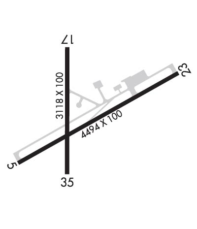
| Lat: N 2109.2 Long: W 15705.8 Elev: 454 Var: -11 Longest Runway: 4494 | ||
| Dept. ATIS: 128.2 Arr. ATIS: 128.2 Ground: 121.9 Tower: 125.7 | ||
| |||||
|
| Rwy | Rwy | |||||||
| 4494x100 | 4494' | 4494x100 | 3901' | |||||
| 3118x100 | 2692' | 3118x100 | 3118' | |||||
| Runway ID | Single Wheel | Double Wheel | Double Tandem Wheel | Dual Double Wheel |
| 05/23 | 30,000 | 48,000 | N/A | N/A |
| 17/35 | 13,000 | N/A | N/A | N/A |
| These numbers are Advisory and are not limits. The Airport Manager should have more accurate Weight Limits | ||||
 Airport Diagram might not be current. | |
| Facility Name: | MOLOKAI |
| City Name: | KAUNAKAKAI |
| County: | MAUI |
| State abbrev: | HI |
| State Name: | HAWAII |
| Ownership: | PUBLICLY OWNED |
| Use: | OPEN TO THE PUBLIC |
| Owner's Name: | HAWAII STATE AIRPORTS DIV |
| Address: | HONOLULU INTL ARPT |
| HONOLULU, HI 96819 | |
| Owner's Phone: | 808-836-6432 |
| Manager's Name: | MARVIN MONIZ |
| Address: | KAHULUI ARPT |
| KAHULUI, HI 96732 | |
| Phone: | 808-872-3808 |
| FAA Region: | WESTERN-PACIFIC |
| FAA Field Office: | HNL |
| Date | Sunrise | Sunset |
|---|---|---|
| 02/19/25 Wednesday | 6:56 | 18:29 |
| 02/20/25 Thursday | 6:56 | 18:29 |
| 02/21/25 Friday | 6:55 | 18:30 |
| 02/22/25 Saturday | 6:54 | 18:30 |
| 02/23/25 Sunday | 6:53 | 18:30 |
| 02/24/25 Monday | 6:53 | 18:31 |
| 02/25/25 Tuesday | 6:52 | 18:31 |
| 02/26/25 Wednesday | 6:51 | 18:32 |
| 02/27/25 Thursday | 6:50 | 18:32 |
| 02/28/25 Friday | 6:50 | 18:33 |
| 03/01/25 Saturday | 6:49 | 18:33 |
| 03/02/25 Sunday | 6:48 | 18:33 |
| 03/03/25 Monday | 6:47 | 18:34 |
| 03/04/25 Tuesday | 6:47 | 18:34 |
| Airport Attendance Schedule | 7 Days A Week 0500-2015 |
| Airport Status | OPERATIONAL (This Status can change at any time - please check NOTAMS) |
| Airport Lighting Schedule | WHEN ATCT CLSD ACTVT MIRL RY 05/23 AND RY 17/35, REIL RY 05 - CTAF. |
| Airport Storage Available | Tie Downs |
| Extra Services Available | Air Freight, Cargo Handling |
| Wind Indicator | YES - (lighted) |
| Control Tower | YES |
| CTAF Frequency | 125.700 |
| Unicom Frequency | |
| Rotating Beacon Color | WG |
| Segmented Circle | YES |
| Landing Fee | NO |
| Airport Inspected | FEDERAL - performed by FAA AIRPORTS FIELD PERSONNEL |
| Inspection Date | 02/17/2022 |
| Type of Fuel Available | None |
| Airframe Repair Service | None |
| Power Plant Repair Service | None |
| Latitude | N2109.2 |
| Longitude | W15705.8 (ESTIMATED) |
| Arpt Elevation | 453ft (SURVEYED) |
| Magnetic Variation | 11E |
| 6 miles NW | of KAUNAKAKAI |
| Traffic Pattern Altitude | |
| Sectional Chart | HAWAIIAN ISLANDS |
| Operations (Reported) | Yearly | Avg. Daily |
|---|---|---|
| General Aviation Transient | 0 | 0 |
| General Aviation Local | 0 | 0 |
| Air Taxi | 0 | 0 |
| Commerical | 0 | 0 |
| Commuter | 0 | 0 |
| Military | 0 | 0 |
| Aircraft based on Field | |
|---|---|
| General Aviation Singles | 0 |
| General Aviation Multi | 0 |
| Jet Aircraft | 0 |
| General Aviation Helicopters | 0 |
| Military Aircraft | 0 |
| Gliders | 0 |
| Ultralights | 0 |
| FSS on field | NO |
| FSS tie-in | HONOLULU |
| FSS Phone | 1-800-WX-BRIEF |
| Who issues Notams | MKK |
| Notam D service at airport | YES |
| ARTCC Name | HONOLULU CONTROL FACILITY |
| Airport Certification | AIRPORT RECEIVING SCHEDULED AIR CARRIER SERVICE FROM CARRIERS CERTIFICATED BY THE CIVIL AERONAUTICS BOARD; ARPT CLOSED TO AIR CARRIER OPS WITH 10 OR MORE PASSENGER SEATS 1930-0600 EXCEPT PPR, CALL 808-567-9660/9663. |
| Aircraft Rescue & Firefighting Index | AIRPORT HAS A CERTIFICATE UNDER CFR PART 139 |
| Airport of Entry | No |
| Custom Landing Rights | No |
| Joint Civil/Military | No |
| Military Landing rights | YES |
| NATIONAL PLAN OF INTEGRATED AIRPORT SYSTEMS (NPIAS) |
| GRANT AGREEMENTS UNDER FAAP/ADAP/AIP |
| ASSURANCES PURSUANT TO TITLE VI, CIVIL RIGHTS ACT OF 1964 |
| AGREEMENT UNDER DLAND OR DCLA HAS EXPIRED. |
| THIS AIRPORT HAS BEEN SURVEYED BY THE NATIONAL GEODETIC SURVEY. |
| 24 HRS PPR FOR DIVISION 1.1,1.2,1.3 EXPLOSIVES AND 4 HRS PPR FOR OTHER HAZARDOUS MATERIAL IN/OUT OF ARPT CTC 808-567-6140/6008. |
| MTN APPROXIMATELY 1280' MSL LCTD 2.8 NM FROM RWY 05 THR ON CNTRLN EXTDD. |
| BE ALERT TO EGRETS AND PIGEONS ON & INVOF ARPT. |
| LARGE ACFT WITH WINGSPAN GREATER THAN 78 FT MAY NOT USE TWY A OR RY 05/23 FOR SIMULTANEOUS OPNS. |
| (E94) LAWRS AVBL FROM TWR PERSONNEL 0600-1900 LCL. |
| STANDING WATER/PONDING ON RY 17/35 NEAR TWY ECHO DURING INCLEMENT WEATHER. |
| FOR CD WHEN ATCT IS CLSD CTC HONOLULU CONTROL FACILITY AT 808-840-6262. |
| (CONTACT TITLE) ARPT OPNS/MAINT/AOM/MR. ANTONE KALILIKANE (808) 567-9660. |
| RWY 05/2 3 PCR VALUE: 104/F/A/X/T |
| RWY 17/3 5 PCR VALUE: 124/F/B/X/T |
Airport Communications & Frequencies:
| |||||||||||||||||||
| Runway: 05 | Runway: 23 | ||
| Mag heading: | 49° | Mag heading: | 229° |
| Rwy Slope: | .37% Up | Rwy Slope: | -.37% Down |
| Approach: | Approach: | ||
| Pattern: | Left Traffic | Pattern: | Left Traffic |
| Markings: | NONPRECISION INSTRUMENT | Markings: | NONPRECISION INSTRUMENT |
| Marking Condition: | GOOD | Marking Condition: | GOOD |
| Arresting Dev: | Arresting Dev: | ||
| Lat & Long: | N2109.0 W15706.1 | Lat. & Long.: | N2109.3 W15705.4 |
| Elev: | 437.1 ft. MSL | Elev: | 453.9 ft. MSL |
| TCH: | 49 ft. AGL | TCH: | |
| Visual Glide Path: | 4.00 degrees | Visual Glide Path: | |
| Displaced Threshold: | No | Displaced Threshold: | 593 feet |
| Touchdown Zone: | YES | Touchdown Zone: | YES |
| Touchdown Elev.: | 441.2 feet | Touchdown Elev.: | 445.2 feet |
| Visual Glide Slope: | 4-Light PAPI on LEFT side of Runway; PAPI NOT AUTHORIZED 1.8 NM BYD LDG THLD DUE TO RAPIDLY RISING TERRAIN. | Visual Glide Slope: | |
| RVR Equipment: | RVR Equipment: | ||
| RVV Equipment: | NO | RVV Equipment: | NO |
| Approach Lights: | Approach Lights: | ||
| REIL: | YES | REIL: | NO |
| Centerline Lights: | NO | Centerline Lights: | NO |
| Touchdown lights: | NO | Touchdown lights: | NO |
| Runway Category: | Runway with a Visual Approach | Runway Category: | Runway with a Visual Approach |
| Declared Distances: | TORA:4494' TODA:4494' ASDA:4494' LDA:4494' | Declared Distances: | TORA:4494' TODA:4494' ASDA:4494' LDA:3901' |
| Obstructions: | Obstructions: | BRUSH; BRUSH 1900' FROM DSPLCD THR. | |
| Marked: | Marked: | NOT Marked/Lighted | |
| Clearance slope: | 50:1 | Clearance slope: | 17:1; APCH RATIO FROM DSPLCD THLD 23:1. |
| Obstruction height: | Obstruction height: | 23 feet AGL | |
| Dist. from runway: | Dist. from runway: | 400 feet | |
| Centerline offset: | Centerline offset: | ||
| Comments: | Comments: |
| Runway: 17 | Runway: 35 | ||
| Mag heading: | 169° | Mag heading: | 349° |
| Rwy Slope: | -.58% Down | Rwy Slope: | .58% Up |
| Approach: | Approach: | ||
| Pattern: | Left Traffic | Pattern: | Left Traffic |
| Markings: | BASIC | Markings: | BASIC |
| Marking Condition: | GOOD | Marking Condition: | GOOD |
| Arresting Dev: | Arresting Dev: | ||
| Lat & Long: | N2109.4 W15705.9 | Lat. & Long.: | N2108.9 W15705.9 |
| Elev: | 448.4 ft. MSL | Elev: | 430.3 ft. MSL |
| TCH: | TCH: | ||
| Visual Glide Path: | Visual Glide Path: | ||
| Displaced Threshold: | 426 feet | Displaced Threshold: | No |
| Touchdown Zone: | YES | Touchdown Zone: | YES |
| Touchdown Elev.: | 442.5 feet | Touchdown Elev.: | 446.8 feet |
| Visual Glide Slope: | Visual Glide Slope: | ||
| RVR Equipment: | RVR Equipment: | ||
| RVV Equipment: | NO | RVV Equipment: | NO |
| Approach Lights: | Approach Lights: | ||
| REIL: | NO | REIL: | NO |
| Centerline Lights: | NO | Centerline Lights: | NO |
| Touchdown lights: | NO | Touchdown lights: | NO |
| Runway Category: | Runway with a Visual Approach | Runway Category: | Runway with a Visual Approach |
| Declared Distances: | TORA:3118' TODA:3118' ASDA:3118' LDA:2692' | Declared Distances: | TORA:3118' TODA:3118' ASDA:3118' LDA:3118' |
| Obstructions: | FENCE | Obstructions: | FENCE |
| Marked: | NOT Marked/Lighted | Marked: | NOT Marked/Lighted |
| Clearance slope: | APCH RATIO 23:1 FROM DSPLCD THLD. | Clearance slope: | 12:1 |
| Obstruction height: | 12 feet AGL | Obstruction height: | 4 feet AGL |
| Dist. from runway: | 80 feet | Dist. from runway: | 248 feet |
| Centerline offset: | Centerline offset: | ||
| Comments: | Comments: |
Thanks for using FltPlan.com
all rights reserved © 1999-2025 by Flight Plan LLC
