| ZELIENOPLE MUNI ZELIENOPLE PA |
| |
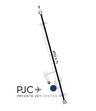
| Lat: N 4048.1 Long: W 08009.7 Elev: 898 Var: +09 Longest Runway: 4933 | ||
| CTAF: 122.9 | ||
| ||||||||||||||||||||||||||||||
| ||||||||||||||||||||||||||||||
| ||||||||||||||||||||||||||||||
| Rwy | Rwy | |||||||
| 4933x75 | 4382' | 4933x75 | 4651' | |||||
| Runway ID | Single Wheel | Double Wheel | Double Tandem Wheel | Dual Double Wheel |
| 17/35 | N/A | N/A | N/A | N/A |
| These numbers are Advisory and are not limits. The Airport Manager should have more accurate Weight Limits | ||||
 Airport Diagram might not be current. | |
| Facility Name: | ZELIENOPLE MUNI |
| City Name: | ZELIENOPLE |
| County: | BEAVER |
| State abbrev: | PA |
| State Name: | PENNSYLVANIA |
| Ownership: | PUBLICLY OWNED |
| Use: | OPEN TO THE PUBLIC |
| Owner's Name: | ARPT AUTH BORO ZELIENOPLE |
| Address: | 100 TASA DRIVE |
| ZELIENOPLE, PA 16063 | |
| Owner's Phone: | 724-452-1290 |
| Manager's Name: | DAVE HOLMAN |
| Address: | 220 TASA DRIVE |
| ZELIENOPLE, PA 16063 | |
| Phone: | 724-452-4719 |
| FAA Region: | EASTERN |
| FAA Field Office: | HAR |
| Date | Sunrise | Sunset |
|---|---|---|
| 09/24/21 Friday | 7:10 | 19:15 |
| 09/25/21 Saturday | 7:11 | 19:13 |
| 09/26/21 Sunday | 7:12 | 19:11 |
| 09/27/21 Monday | 7:13 | 19:10 |
| 09/28/21 Tuesday | 7:14 | 19:08 |
| 09/29/21 Wednesday | 7:15 | 19:06 |
| 09/30/21 Thursday | 7:16 | 19:05 |
| 10/01/21 Friday | 7:17 | 19:03 |
| 10/02/21 Saturday | 7:18 | 19:01 |
| 10/03/21 Sunday | 7:19 | 19:00 |
| 10/04/21 Monday | 7:20 | 18:58 |
| 10/05/21 Tuesday | 7:21 | 18:56 |
| 10/06/21 Wednesday | 7:22 | 18:55 |
| 10/07/21 Thursday | 7:23 | 18:53 |
| Airport Attendance Schedule | MON-FRI 0600-2200, SAT-SUN ON CALL; FOR ATTENDANT SAT-SUN CALL 724-452-4719. |
| Airport Status | OPERATIONAL (This Status can change at any time - please check NOTAMS) |
| Airport Lighting Schedule | ACTVT REIL RWY 17 & 35; MIRL RWY 17/35 AFT 2200 - CTAF. PAPI CONS & MIRL OPER DUSK-2200. |
| Airport Storage Available | Tie Downs, Hanger |
| Extra Services Available | Charter, Flight Instruction |
| Wind Indicator | YES - (lighted) |
| Control Tower | NO |
| CTAF Frequency | 122.900 |
| Unicom Frequency | |
| Rotating Beacon Color | CLEAR-GREEN (Light Land Airport) |
| Segmented Circle | NO |
| Landing Fee | NO |
| Airport Inspected | STATE - performed by STATE AERONAUTICAL PERSONNEL |
| Inspection Date | 10/13/2020 |
| Type of Fuel Available | Grade 100LL, JET A (freeze point -40C), JET A |
| Airframe Repair Service | MAJOR |
| Power Plant Repair Service | MAJOR |
| Latitude | N4048.1 |
| Longitude | W08009.7 (ESTIMATED) |
| Arpt Elevation | 897ft (SURVEYED) |
| Magnetic Variation | 09W |
| 1 miles W | of ZELIENOPLE |
| Traffic Pattern Altitude | |
| Sectional Chart | DETROIT |
| Operations (Reported) | Yearly | Avg. Daily |
|---|---|---|
| General Aviation Transient | 6400 | 18 |
| General Aviation Local | 33315 | 91 |
| Air Taxi | 2100 | 6 |
| Commerical | 0 | 0 |
| Commuter | 0 | 0 |
| Military | 160 | 0 |
| Aircraft based on Field | |
|---|---|
| General Aviation Singles | 35 |
| General Aviation Multi | 3 |
| Jet Aircraft | 6 |
| General Aviation Helicopters | 6 |
| Military Aircraft | 0 |
| Gliders | 0 |
| Ultralights | 0 |
| FSS on field | NO |
| FSS tie-in | ALTOONA |
| FSS Phone | 1-800-WX-BRIEF |
| Who issues Notams | AOO |
| Notam D service at airport | YES |
| ARTCC Name | CLEVELAND |
| Airport Certification | |
| Aircraft Rescue & Firefighting Index | None |
| Airport of Entry | No |
| Custom Landing Rights | No |
| Joint Civil/Military | No |
| Military Landing rights | No |
| NATIONAL PLAN OF INTEGRATED AIRPORT SYSTEMS (NPIAS) |
| GRANT AGREEMENTS UNDER FAAP/ADAP/AIP |
| ASSURANCES PURSUANT TO TITLE VI, CIVIL RIGHTS ACT OF 1964 |
| DEER & GEESE ON & INVOF RWY. |
| PARALLEL TXY MKD WITH REFLECTORS. |
| FOR CD CTC PITTSBURGH APCH AT 412-472-5591. |
| RWY 35 68 FT LGT POLE 720 FT FM THLD, 291 FT RT. 56 FT LGT POLE 480 FT FM THLD, 267 FT LT. POLES LGT FM THE BOTTOM. |
Airport Communications & Frequencies:
| ||||||||||||
| Runway: 17 | Runway: 35 | ||
| Mag heading: | 174° | Mag heading: | 354° |
| Rwy Slope: | .13% Up | Rwy Slope: | -.13% Down |
| Approach: | Approach: | ||
| Pattern: | Left Traffic | Pattern: | Left Traffic |
| Markings: | NONPRECISION INSTRUMENT | Markings: | NONPRECISION INSTRUMENT |
| Marking Condition: | GOOD | Marking Condition: | GOOD |
| Arresting Dev: | Arresting Dev: | ||
| Lat & Long: | N4048.5 W08009.8 | Lat. & Long.: | N4047.7 W08009.5 |
| Elev: | 889.9 ft. MSL | Elev: | 896.2 ft. MSL |
| TCH: | TCH: | 50 ft. AGL | |
| Visual Glide Path: | Visual Glide Path: | 3.48 degrees | |
| Displaced Threshold: | 551 feet | Displaced Threshold: | 282 feet |
| Touchdown Zone: | YES | Touchdown Zone: | YES |
| Touchdown Elev.: | 896.7 feet | Touchdown Elev.: | 897.8 feet |
| Visual Glide Slope: | Visual Glide Slope: | 2-Light PAPI on LEFT side of Runway; PAPI UNUSBL BYD 5 DEG L OF CNTRLN. | |
| RVR Equipment: | RVR Equipment: | ||
| RVV Equipment: | NO | RVV Equipment: | NO |
| Approach Lights: | Approach Lights: | ||
| REIL: | YES | REIL: | YES |
| Centerline Lights: | NO | Centerline Lights: | NO |
| Touchdown lights: | NO | Touchdown lights: | NO |
| Runway Category: | Runway with a Non-precision Approach having visibility minimums greater than 3/4 mile | Runway Category: | Runway with a Non-precision Approach having visibility minimums greater than 3/4 mile |
| Declared Distances: | TORA:4932' TODA:4932' ASDA:4932' LDA:4381' | Declared Distances: | TORA:4932' TODA:4932' ASDA:4932' LDA:4650' |
| Obstructions: | TREES | Obstructions: | POLE |
| Marked: | NOT Marked/Lighted | Marked: | LIGHTED; NON-STD LGTG; UTILITY POLE LIT FROM THE BOTTOM. |
| Clearance slope: | RWY 17 82 FT TREES 226 FT FROM THLD 215 FT L. 9:1 TO DTHR. | Clearance slope: | 5:1 |
| Obstruction height: | 82 feet AGL | Obstruction height: | 56 feet AGL |
| Dist. from runway: | 226 feet | Dist. from runway: | 480 feet |
| Centerline offset: | 215 left of centerline | Centerline offset: | 267 feet left of centerline |
| Comments: | Comments: |
Thanks for using FltPlan.com
all rights reserved © 1999-2021 by Flight Plan LLC