
| PELLSTON RGNL AIRPORT OF EMMET PELLSTON MI |
| |
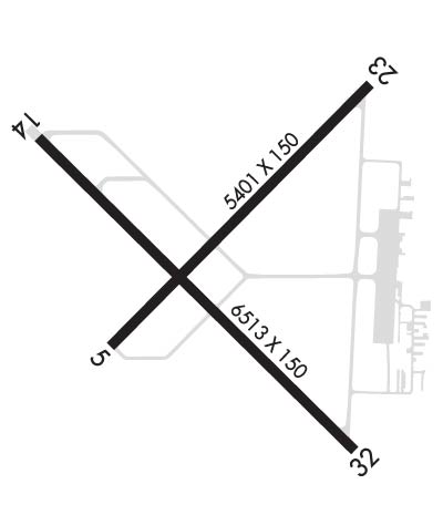
| Lat: N 4534.3 Long: W 08447.8 Elev: 721 Var: +06 Longest Runway: 6513 | ||
| AWOS: 119.02 CTAF: 123.0 | ||
| ||||||||||||||||||||||||||||||||||||||||||||
| ||||||||||||||||||||||||||||||||||||||||||||
| ||||||||||||||||||||||||||||||||||||||||||||
| Rwy | Rwy | |||||||
| 5401x150 | 5401' | 5401x150 | 5401' | |||||
| 6513x150 | 6513' | 6513x150 | 6513' | 111.30 - 320° | ||||
| Runway ID | Single Wheel | Double Wheel | Double Tandem Wheel | Dual Double Wheel |
| 05/23 | 76,000 | 115,000 | 215,000 | N/A |
| 14/32 | 76,000 | 115,000 | 215,000 | N/A |
| These numbers are Advisory and are not limits. The Airport Manager should have more accurate Weight Limits | ||||
 Airport Diagram might not be current. | |
| Facility Name: | PELLSTON RGNL/EMMET COUNTY |
| City Name: | PELLSTON |
| County: | EMMET |
| State abbrev: | MI |
| State Name: | MICHIGAN |
| Ownership: | PUBLICLY OWNED |
| Use: | OPEN TO THE PUBLIC |
| Owner's Name: | EMMET COUNTY |
| Address: | 1395 N US HIGHWAY 31 |
| PELLSTON, MI 49769-9307 | |
| Owner's Phone: | 231-539-8441 |
| Manager's Name: | RYAN BACHELOR |
| Address: | 1395 N US HIGHWAY 31 |
| PELLSTON, MI 49769-9307 | |
| Phone: | 231-539-8442 |
| FAA Region: | GREAT LAKES |
| FAA Field Office: | DET |
| Date | Sunrise | Sunset |
|---|---|---|
| 03/16/25 Sunday | 7:50 | 19:46 |
| 03/17/25 Monday | 7:49 | 19:48 |
| 03/18/25 Tuesday | 7:47 | 19:49 |
| 03/19/25 Wednesday | 7:45 | 19:50 |
| 03/20/25 Thursday | 7:43 | 19:52 |
| 03/21/25 Friday | 7:41 | 19:53 |
| 03/22/25 Saturday | 7:39 | 19:54 |
| 03/23/25 Sunday | 7:37 | 19:55 |
| 03/24/25 Monday | 7:35 | 19:57 |
| 03/25/25 Tuesday | 7:33 | 19:58 |
| 03/26/25 Wednesday | 7:31 | 19:59 |
| 03/27/25 Thursday | 7:29 | 20:01 |
| 03/28/25 Friday | 7:28 | 20:02 |
| 03/29/25 Saturday | 7:26 | 20:03 |
| Airport Attendance Schedule | 7 Days A Week 0600-2300 |
| Airport Status | OPERATIONAL (This Status can change at any time - please check NOTAMS) |
| Airport Lighting Schedule | ACTVT MALSR RWY 32; REIL RWY 14, 05, & 23; PAPI RWY 14; HIRL RWY 14/32; MIRL RWY 05/23 - CTAF. VASI RWY 05 & 23 OPR CONSLY. |
| Airport Storage Available | Tie Downs |
| Extra Services Available | Charter |
| Wind Indicator | YES - (lighted) |
| Control Tower | NO |
| CTAF Frequency | 123.000 |
| Unicom Frequency | 123.000 |
| Rotating Beacon Color | WG |
| Segmented Circle | YES |
| Landing Fee | YES; FAC FEE WAIVED WITH MNM FUEL PURCHASE. |
| Airport Inspected | FEDERAL - performed by FAA AIRPORTS FIELD PERSONNEL |
| Inspection Date | 05/09/2024 |
| Type of Fuel Available | Grade 100LL, JET A (freeze point -40C) |
| Airframe Repair Service | MAJOR |
| Power Plant Repair Service | MAJOR |
| Latitude | N4534.3 |
| Longitude | W08447.8 (ESTIMATED) |
| Arpt Elevation | 720ft (SURVEYED) |
| Magnetic Variation | 06W |
| 1 miles NW | of PELLSTON |
| Traffic Pattern Altitude | |
| Sectional Chart | LAKE HURON |
| Operations (Reported) | Yearly | Avg. Daily |
|---|---|---|
| General Aviation Transient | 0 | 0 |
| General Aviation Local | 0 | 0 |
| Air Taxi | 0 | 0 |
| Commerical | 0 | 0 |
| Commuter | 0 | 0 |
| Military | 0 | 0 |
| Aircraft based on Field | |
|---|---|
| General Aviation Singles | 0 |
| General Aviation Multi | 0 |
| Jet Aircraft | 0 |
| General Aviation Helicopters | 0 |
| Military Aircraft | 0 |
| Gliders | 0 |
| Ultralights | 0 |
| FSS on field | NO |
| FSS tie-in | LANSING |
| FSS Phone | 1-800-WX-BRIEF |
| Who issues Notams | PLN |
| Notam D service at airport | YES |
| ARTCC Name | MINNEAPOLIS |
| Airport Certification | AIRPORT RECEIVING SCHEDULED AIR CARRIER SERVICE FROM CARRIERS CERTIFICATED BY THE CIVIL AERONAUTICS BOARD; ARPT CLSD TO UNSKED ACR ACFT WITH MORE THAN 30 PSGR SEATS EXCP 24 HR PPR. |
| Aircraft Rescue & Firefighting Index | AIRPORT HAS A CERTIFICATE UNDER CFR PART 139 |
| Airport of Entry | No |
| Custom Landing Rights | No |
| Joint Civil/Military | No |
| Military Landing rights | YES |
| NATIONAL PLAN OF INTEGRATED AIRPORT SYSTEMS (NPIAS) |
| GRANT AGREEMENTS UNDER FAAP/ADAP/AIP |
| ASSURANCES PURSUANT TO TITLE VI, CIVIL RIGHTS ACT OF 1964 |
| AGREEMENT UNDER DLAND OR DCLA HAS EXPIRED. |
| DEER & GULLS OCNLY ON & INVOF ARPT. |
| BE ALERT FOR SNOW REMOVAL EQUIP & ACTIVITY ON & INVOF RYS DURG WINTER MONTHS. |
| TWY B1 & E1 CLSD 1 NOV THRU 15 APR.. |
| SFC CONDS UNMON 2300-0530 DLY. |
| FOR CD IF UNA TO CTC ON FSS FREQ, CTC MINNEAPOLIS ARTCC AT 651-463-5588. |
Airport Communications & Frequencies:
| |||||||||
| Runway: 05 | Runway: 23 | ||
| Mag heading: | 51° | Mag heading: | 231° |
| Rwy Slope: | .18% Up | Rwy Slope: | -.18% Down |
| Approach: | Approach: | ||
| Pattern: | Left Traffic | Pattern: | Left Traffic |
| Markings: | NONPRECISION INSTRUMENT | Markings: | NONPRECISION INSTRUMENT |
| Marking Condition: | GOOD | Marking Condition: | GOOD |
| Arresting Dev: | Arresting Dev: | ||
| Lat & Long: | N4534.0 W08448.2 | Lat. & Long.: | N4534.7 W08447.3 |
| Elev: | 710.6 ft. MSL | Elev: | 720.5 ft. MSL |
| TCH: | 48 ft. AGL | TCH: | 45 ft. AGL |
| Visual Glide Path: | 3.00 degrees | Visual Glide Path: | 3.00 degrees |
| Displaced Threshold: | No | Displaced Threshold: | No |
| Touchdown Zone: | YES | Touchdown Zone: | YES |
| Touchdown Elev.: | 715.6 feet | Touchdown Elev.: | 720.6 feet |
| Visual Glide Slope: | 4-BOX VASI ON RIGHT SIDE OF RUNWAY | Visual Glide Slope: | 4-BOX VASI ON LEFT SIDE OF RUNWAY |
| RVR Equipment: | RVR Equipment: | ||
| RVV Equipment: | NO | RVV Equipment: | NO |
| Approach Lights: | Approach Lights: | ||
| REIL: | YES | REIL: | YES |
| Centerline Lights: | NO | Centerline Lights: | NO |
| Touchdown lights: | NO | Touchdown lights: | NO |
| Runway Category: | Runway with a Non-precision Approach having visibility minimums greater than 3/4 mile | Runway Category: | Runway with a Non-precision Approach having visibility minimums greater than 3/4 mile |
| Declared Distances: | TORA:5395' TODA:5395' ASDA:5395' LDA:5395' | Declared Distances: | TORA:5395' TODA:5395' ASDA:5395' LDA:5395' |
| Obstructions: | TREES | Obstructions: | ROAD |
| Marked: | NOT Marked/Lighted | Marked: | NOT Marked/Lighted |
| Clearance slope: | 26:1 | Clearance slope: | 26:1 |
| Obstruction height: | 50 feet AGL | Obstruction height: | 18 feet AGL |
| Dist. from runway: | 1500 feet | Dist. from runway: | 669 feet |
| Centerline offset: | 300 right of centerline | Centerline offset: | 316 feet right of centerline |
| Comments: | Comments: |
| Runway: 14 | Runway: 32 | ||
| Mag heading: | 141° | Mag heading: | 321° |
| Rwy Slope: | -.16% Down | Rwy Slope: | .16% Up |
| Approach: | Approach: | ILS/DME | |
| Pattern: | Left Traffic | Pattern: | Left Traffic |
| Markings: | PRECISION INSTRUMENT | Markings: | PRECISION INSTRUMENT |
| Marking Condition: | FAIR | Marking Condition: | FAIR |
| Arresting Dev: | Arresting Dev: | ||
| Lat & Long: | N4534.5 W08448.4 | Lat. & Long.: | N4533.8 W08447.3 |
| Elev: | 718.0 ft. MSL | Elev: | 707.5 ft. MSL |
| TCH: | 49 ft. AGL | TCH: | |
| Visual Glide Path: | 3.00 degrees | Visual Glide Path: | |
| Displaced Threshold: | No | Displaced Threshold: | No |
| Touchdown Zone: | YES | Touchdown Zone: | YES |
| Touchdown Elev.: | 718.1 feet | Touchdown Elev.: | 711.8 feet |
| Visual Glide Slope: | 4-Light PAPI on LEFT side of Runway; UNUSBL BYD 8 DEGS RIGHT OF CNTRLN. | Visual Glide Slope: | |
| RVR Equipment: | RVR Equipment: | ||
| RVV Equipment: | NO | RVV Equipment: | NO |
| Approach Lights: | Approach Lights: | MALSR - 1,400 foot medium intensity approach lighting system with runway alignment indicator lights | |
| REIL: | YES | REIL: | NO |
| Centerline Lights: | NO | Centerline Lights: | NO |
| Touchdown lights: | NO | Touchdown lights: | NO |
| Runway Category: | Runway with a Visual Approach | Runway Category: | Precision Instrument Runway |
| Declared Distances: | TORA:6513' TODA:6513' ASDA:6512' LDA:6512' | Declared Distances: | TORA:6513' TODA:6513' ASDA:6513' LDA:6513' |
| Obstructions: | TREES | Obstructions: | TREE |
| Marked: | NOT Marked/Lighted | Marked: | NOT Marked/Lighted |
| Clearance slope: | 32:1 | Clearance slope: | 45:1 |
| Obstruction height: | 82 feet AGL | Obstruction height: | 56 feet AGL |
| Dist. from runway: | 2850 feet | Dist. from runway: | 2739 feet |
| Centerline offset: | Centerline offset: | 865 feet left of centerline | |
| Comments: | Comments: |
Thanks for using FltPlan.com
all rights reserved © 1999-2025 by Flight Plan LLC
