
| NORTHEAST PHILADELPHIA PHILADELPHIA PA |
| |
| Lat: N 4004.9 Long: W 07500.6 Elev: 120 Var: +12 Longest Runway: 7000 | ||
| Clr Del: 127.25 Dept. ATIS: 121.15 Arr. ATIS: 121.15 AWOS: 121.15 Ground: 121.7 Tower: 126.9 | ||
| ||||||||||||||||||||||||||||||||||||||||||||||||||||||||||||||||||||
| ||||||||||||||||||||||||||||||||||||||||||||||||||||||||||||||||||||
| ||||||||||||||||||||||||||||||||||||||||||||||||||||||||||||||||||||
| ||||||||||||||||||||||||||||||||||||||||||||||||||||||||||||||||||||
| Rwy | Rwy | |||||||
| 7000x100 | 7000' | 7000x100 | 7000' | 111.10 - 240° | ||||
| 5000x150 | 5000' | 5000x150 | 5000' | |||||
| Runway ID | Single Wheel | Double Wheel | Double Tandem Wheel | Dual Double Wheel |
| 06/24 | 60,000 | 90,000 | N/A | N/A |
| 15/33 | 40,000 | 55,000 | N/A | N/A |
| These numbers are Advisory and are not limits. The Airport Manager should have more accurate Weight Limits | ||||
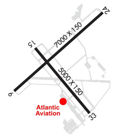 Airport Diagram might not be current. | |
| Facility Name: | NORTHEAST PHILADELPHIA |
| City Name: | PHILADELPHIA |
| County: | PHILADELPHIA |
| State abbrev: | PA |
| State Name: | PENNSYLVANIA |
| Ownership: | PUBLICLY OWNED |
| Use: | OPEN TO THE PUBLIC |
| Owner's Name: | CITY OF PHILADELPHIA |
| Address: | PHILADELPHIA INT ARPT |
| PHILADELPHIA, PA 19153 | |
| Owner's Phone: | 215-937-6800 |
| Manager's Name: | JOHN BREWER |
| Address: | 9800 ASHTON ROAD |
| PHILADELPHIA, PA 19114 | |
| Phone: | 215-937-7968 |
| FAA Region: | EASTERN |
| FAA Field Office: | HAR |
| Date | Sunrise | Sunset |
|---|---|---|
| 09/24/21 Friday | 6:49 | 18:54 |
| 09/25/21 Saturday | 6:50 | 18:53 |
| 09/26/21 Sunday | 6:51 | 18:51 |
| 09/27/21 Monday | 6:52 | 18:49 |
| 09/28/21 Tuesday | 6:53 | 18:48 |
| 09/29/21 Wednesday | 6:54 | 18:46 |
| 09/30/21 Thursday | 6:55 | 18:44 |
| 10/01/21 Friday | 6:56 | 18:43 |
| 10/02/21 Saturday | 6:57 | 18:41 |
| 10/03/21 Sunday | 6:58 | 18:40 |
| 10/04/21 Monday | 6:59 | 18:38 |
| 10/05/21 Tuesday | 7:00 | 18:36 |
| 10/06/21 Wednesday | 7:01 | 18:35 |
| 10/07/21 Thursday | 7:02 | 18:33 |
| Airport Attendance Schedule | SAT-SUN 0600-2230, MON-FRI 0500-0030 |
| Airport Status | OPERATIONAL (This Status can change at any time - please check NOTAMS) |
| Airport Lighting Schedule | WHEN ATCT CLSD HIRL RWY 06/24 PRESET MED INTST; ACTVT MALSR RWY 24 - CTAF |
| Airport Storage Available | Tie Downs, Hanger |
| Extra Services Available | Air Freight, Air Ambulance, Avionics, Cargo Handling, Charter, Flight Instruction, Aircraft Rental, Aircraft Sales, Annual Surveying |
| Wind Indicator | YES - (lighted) |
| Control Tower | YES |
| CTAF Frequency | 126.900 |
| Unicom Frequency | 122.950 |
| Rotating Beacon Color | CLEAR-GREEN (Light Land Airport) |
| Segmented Circle | NO |
| Landing Fee | YES |
| Airport Inspected | STATE - performed by STATE AERONAUTICAL PERSONNEL |
| Inspection Date | 11/10/2020 |
| Type of Fuel Available | Grade 100LL, JET A (freeze point -40C) |
| Airframe Repair Service | MAJOR |
| Power Plant Repair Service | MAJOR |
| Latitude | N4004.9 |
| Longitude | W07500.6 (ESTIMATED) |
| Arpt Elevation | 119ft (SURVEYED) |
| Magnetic Variation | 12W |
| 10 miles NE | of PHILADELPHIA |
| Traffic Pattern Altitude | |
| Sectional Chart | NEW YORK |
| Operations (Reported) | Yearly | Avg. Daily |
|---|---|---|
| General Aviation Transient | 40281 | 110 |
| General Aviation Local | 30931 | 85 |
| Air Taxi | 4572 | 13 |
| Commerical | 0 | 0 |
| Commuter | 0 | 0 |
| Military | 188 | 1 |
| Aircraft based on Field | |
|---|---|
| General Aviation Singles | 79 |
| General Aviation Multi | 31 |
| Jet Aircraft | 14 |
| General Aviation Helicopters | 7 |
| Military Aircraft | 0 |
| Gliders | 0 |
| Ultralights | 0 |
| FSS on field | NO |
| FSS tie-in | WILLIAMSPORT |
| FSS Phone | 1-800-WX-BRIEF |
| Who issues Notams | PNE |
| Notam D service at airport | YES |
| ARTCC Name | WASHINGTON |
| Airport Certification | |
| Aircraft Rescue & Firefighting Index | None |
| Airport of Entry | No |
| Custom Landing Rights | YES; CBP USER FEE ARPT, 24 HR PPR BY CALLING (215) 594-4272 OR (215) 594-4141. |
| Joint Civil/Military | No |
| Military Landing rights | YES |
| NATIONAL PLAN OF INTEGRATED AIRPORT SYSTEMS (NPIAS) |
| GRANT AGREEMENTS UNDER FAAP/ADAP/AIP |
| ASSURANCES PURSUANT TO TITLE VI, CIVIL RIGHTS ACT OF 1964 |
| AGREEMENT UNDER DLAND OR DCLA HAS EXPIRED. |
| TURBOJET ACFT ARE CONFINED TO FULL LENGTH RWY 6/24 UNLESS STRONG WINDS DICTATE OTHERWISE. |
| BE ALERT: 3 LARGE BRIGHTLY LIT JUMBOTRON SIGNS APRX 3 MILES NE OF AER 24. THESE SIGNS MAY CAUSE VISUAL ILLUSIONS DURING AN APCH OR MISSED APCH. PILOTS BE AT ADVISED. |
| FOR CD WHEN ATCT IS CLSD CTC PHL APCH AT (800) 354-9884. |
| TWY L3 SAFETY AREA NON STD. |
| TWY J1 NON MOVEMENT AREA. |
| COMPASS ROSE NOT FOR PUB USE. |
| TWY J BTN TWY G AND TWY L APN NON MOVEMENT AREA. |
| RWY 15 IS NOISE SENSITIVE. RWY 15 ARRIVALS ARE REQUESTED TO FLY AT OR ABOVE GLIDE PATH. |
| ARPT CLSD TO PART 121 AIR CARRIER AND PART 135 SCHEDULED SVC. |
| DEER & BIRDS ON & INVOF ARPT. |
| NO MIL PRACTICE APCHS WITHOUT PRIOR APVL. |
| TPA ACFT LESS THAN 12500 LBS 1120 MSL; ACFT 12500 LBS OR MORE & ALL TURBOJET & TURBINE PWRD ACFT 1620 MSL; ROTARY WING ACFT 920 MSL. |
| BE ALERT FOR ARPT VEHICLES WHEN TWR CLSD. |
Airport Communications & Frequencies:
| |||||||||||||||||||||||||||
| Runway: 06 | Runway: 24 | ||
| Mag heading: | 60° | Mag heading: | 240° |
| Rwy Slope: | .04% Up | Rwy Slope: | -.04% Down |
| Approach: | Approach: | ILS | |
| Pattern: | Left Traffic | Pattern: | Left Traffic |
| Markings: | PRECISION INSTRUMENT | Markings: | PRECISION INSTRUMENT |
| Marking Condition: | GOOD | Marking Condition: | GOOD |
| Arresting Dev: | Arresting Dev: | ||
| Lat & Long: | N4004.7 W07501.2 | Lat. & Long.: | N4005.4 W07500.1 |
| Elev: | 110.8 ft. MSL | Elev: | 113.6 ft. MSL |
| TCH: | 57 ft. AGL | TCH: | 53 ft. AGL |
| Visual Glide Path: | 3.00 degrees | Visual Glide Path: | 3.00 degrees |
| Displaced Threshold: | No | Displaced Threshold: | No |
| Touchdown Zone: | YES | Touchdown Zone: | YES |
| Touchdown Elev.: | 115.7 feet | Touchdown Elev.: | 114.8 feet |
| Visual Glide Slope: | 4-Light PAPI on LEFT side of Runway | Visual Glide Slope: | 4-Light PAPI on RIGHT side of Runway |
| RVR Equipment: | RVR Equipment: | ||
| RVV Equipment: | NO | RVV Equipment: | NO |
| Approach Lights: | Approach Lights: | MALSR - 1,400 foot medium intensity approach lighting system with runway alignment indicator lights | |
| REIL: | YES | REIL: | NO |
| Centerline Lights: | NO | Centerline Lights: | NO |
| Touchdown lights: | NO | Touchdown lights: | NO |
| Runway Category: | Runway with a Non-precision Approach having visibility minimums greater than 3/4 mile | Runway Category: | Precision Instrument Runway |
| Declared Distances: | Declared Distances: | ||
| Obstructions: | TREES | Obstructions: | TREES |
| Marked: | NOT Marked/Lighted | Marked: | NOT Marked/Lighted |
| Clearance slope: | 25:1 | Clearance slope: | 23:1 |
| Obstruction height: | 47 feet AGL | Obstruction height: | 64 feet AGL |
| Dist. from runway: | 1384 feet | Dist. from runway: | 1701 feet |
| Centerline offset: | 72 left of centerline | Centerline offset: | 722 feet left of centerline |
| Comments: | Comments: |
| Runway: 15 | Runway: 33 | ||
| Mag heading: | 153° | Mag heading: | 333° |
| Rwy Slope: | -.24% Down | Rwy Slope: | .24% Up |
| Approach: | Approach: | ||
| Pattern: | Left Traffic | Pattern: | Left Traffic |
| Markings: | NONPRECISION INSTRUMENT | Markings: | NONPRECISION INSTRUMENT |
| Marking Condition: | GOOD | Marking Condition: | GOOD |
| Arresting Dev: | Arresting Dev: | ||
| Lat & Long: | N4005.1 W07500.9 | Lat. & Long.: | N4004.4 W07500.3 |
| Elev: | 119.8 ft. MSL | Elev: | 107.9 ft. MSL |
| TCH: | 39 ft. AGL | TCH: | 39 ft. AGL |
| Visual Glide Path: | 3.00 degrees | Visual Glide Path: | 3.00 degrees |
| Displaced Threshold: | No | Displaced Threshold: | No |
| Touchdown Zone: | YES | Touchdown Zone: | YES |
| Touchdown Elev.: | 119.9 feet | Touchdown Elev.: | 108.0 feet |
| Visual Glide Slope: | 4-Light PAPI on LEFT side of Runway | Visual Glide Slope: | 4-Light PAPI on LEFT side of Runway |
| RVR Equipment: | RVR Equipment: | ||
| RVV Equipment: | NO | RVV Equipment: | NO |
| Approach Lights: | Approach Lights: | ||
| REIL: | YES | REIL: | YES |
| Centerline Lights: | NO | Centerline Lights: | NO |
| Touchdown lights: | NO | Touchdown lights: | NO |
| Runway Category: | Runway with a Non-precision Approach having visibility minimums greater than 3/4 mile | Runway Category: | Runway with a Non-precision Approach having visibility minimums greater than 3/4 mile |
| Declared Distances: | Declared Distances: | ||
| Obstructions: | TREES | Obstructions: | TREES |
| Marked: | NOT Marked/Lighted | Marked: | NOT Marked/Lighted |
| Clearance slope: | 23:1 | Clearance slope: | 27:1 |
| Obstruction height: | 89 feet AGL | Obstruction height: | 46 feet AGL |
| Dist. from runway: | 2315 feet | Dist. from runway: | 1437 feet |
| Centerline offset: | 202 right of centerline | Centerline offset: | 227 feet right of centerline |
| Comments: | Comments: |
Thanks for using FltPlan.com
all rights reserved © 1999-2021 by Flight Plan LLC


