
| NORTHERN MAINE RGNL PRESQUE ISLE ME |
| |
| Lat: N 4641.3 Long: W 06802.7 Elev: 534 Var: +17 Longest Runway: 7441 | ||
| Clr Del: 121.6 AWOS: 118.02 CTAF: 122.8 | ||
| ||||||||||||||||||||||||||||||||||||||||||||
| ||||||||||||||||||||||||||||||||||||||||||||
| ||||||||||||||||||||||||||||||||||||||||||||
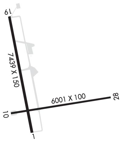
| Rwy | Rwy | |||||||
| 7441x150 | 7441' | 108.70 - 005° | 7441x150 | 7441' | ||||
| 6000x100 | 6000' | 6000x100 | 6000' | |||||
| Runway ID | Single Wheel | Double Wheel | Double Tandem Wheel | Dual Double Wheel |
| 01/19 | 100,000 | 150,000 | 240,000 | N/A |
| 10/28 | 100,000 | 150,000 | 240,000 | N/A |
| These numbers are Advisory and are not limits. The Airport Manager should have more accurate Weight Limits | ||||
 Airport Diagram might not be current. | |
| Facility Name: | PRESQUE ISLE INTL |
| City Name: | PRESQUE ISLE |
| County: | AROOSTOOK |
| State abbrev: | ME |
| State Name: | MAINE |
| Ownership: | PUBLICLY OWNED |
| Use: | OPEN TO THE PUBLIC |
| Owner's Name: | CITY OF PRESQUE ISLE |
| Address: | 12 SECOND ST |
| PRESQUE ISLE, ME 04769 | |
| Owner's Phone: | 207-764-4485 |
| Manager's Name: | SCOTT WARDWELL |
| Address: | 650 AIRPORT DR SUITE 11 |
| PRESQUE ISLE, ME 04769 | |
| Phone: | 207-764-2550 |
| FAA Region: | NEW ENGLAND |
| FAA Field Office: | NONE |
| Date | Sunrise | Sunset |
|---|---|---|
| 09/24/21 Friday | 6:21 | 18:26 |
| 09/25/21 Saturday | 6:23 | 18:24 |
| 09/26/21 Sunday | 6:24 | 18:22 |
| 09/27/21 Monday | 6:25 | 18:20 |
| 09/28/21 Tuesday | 6:26 | 18:18 |
| 09/29/21 Wednesday | 6:28 | 18:16 |
| 09/30/21 Thursday | 6:29 | 18:14 |
| 10/01/21 Friday | 6:30 | 18:12 |
| 10/02/21 Saturday | 6:32 | 18:11 |
| 10/03/21 Sunday | 6:33 | 18:09 |
| 10/04/21 Monday | 6:34 | 18:07 |
| 10/05/21 Tuesday | 6:36 | 18:05 |
| 10/06/21 Wednesday | 6:37 | 18:03 |
| 10/07/21 Thursday | 6:38 | 18:01 |
| Airport Attendance Schedule | 7 Days A Week 0600-1900 |
| Airport Status | OPERATIONAL (This Status can change at any time - please check NOTAMS) |
| Airport Lighting Schedule | ACTVT MALSR RWY 01; REIL RWY 19; PAPI RWY 19 & 28; HIRL RWY 01/19; MIRL RWY 10/28 - 122.6. |
| Airport Storage Available | Tie Downs, Hanger |
| Extra Services Available | Crop Dusting, Air Ambulance, Cargo Handling, Charter, Flight Instruction, Aircraft Rental |
| Wind Indicator | YES - (lighted) |
| Control Tower | NO |
| CTAF Frequency | 122.800 |
| Unicom Frequency | 122.800 |
| Rotating Beacon Color | CLEAR-GREEN (Light Land Airport) |
| Segmented Circle | YES |
| Landing Fee | NO |
| Airport Inspected | FEDERAL - performed by FAA AIRPORTS FIELD PERSONNEL |
| Inspection Date | 08/19/2019 |
| Type of Fuel Available | Grade 100LL, JET A (freeze point -40C) |
| Airframe Repair Service | MINOR |
| Power Plant Repair Service | MINOR |
| Latitude | N4641.3 |
| Longitude | W06802.7 (ESTIMATED) |
| Arpt Elevation | 534ft (SURVEYED) |
| Magnetic Variation | 17W |
| 1 miles NW | of PRESQUE ISLE |
| Traffic Pattern Altitude | |
| Sectional Chart | HALIFAX |
| Operations (Reported) | Yearly | Avg. Daily |
|---|---|---|
| General Aviation Transient | 1887 | 5 |
| General Aviation Local | 869 | 2 |
| Air Taxi | 3976 | 11 |
| Commerical | 1324 | 4 |
| Commuter | 0 | 0 |
| Military | 50 | 0 |
| Aircraft based on Field | |
|---|---|
| General Aviation Singles | 16 |
| General Aviation Multi | 1 |
| Jet Aircraft | 1 |
| General Aviation Helicopters | 0 |
| Military Aircraft | 0 |
| Gliders | 0 |
| Ultralights | 0 |
| FSS on field | NO |
| FSS tie-in | BANGOR |
| FSS Phone | 1-800-WX-BRIEF |
| Who issues Notams | PQI |
| Notam D service at airport | YES |
| ARTCC Name | BOSTON |
| Airport Certification | AIRPORT RECEIVING SCHEDULED AIR CARRIER SERVICE FROM CARRIERS CERTIFICATED BY THE CIVIL AERONAUTICS BOARD; CLSD TO UNSKED ACR OPNS WITH MORE THAN 30 PSGR SEATS, EXCP PPR CALL AMGR 207-764-2550. |
| Aircraft Rescue & Firefighting Index | AIRPORT HAS A CERTIFICATE UNDER CFR PART 139 |
| Airport of Entry | No |
| Custom Landing Rights | YES |
| Joint Civil/Military | No |
| Military Landing rights | YES |
| NATIONAL PLAN OF INTEGRATED AIRPORT SYSTEMS (NPIAS) |
| GRANT AGREEMENTS UNDER FAAP/ADAP/AIP |
| SURPLUS PROPERTY AGREEMENT UNDER PUBLIC LAW 289 |
| ASSURANCES PURSUANT TO TITLE VI, CIVIL RIGHTS ACT OF 1964 |
| PAEW ADJ TO RWYS & TWYS (MOWING) MAY 1 THRU NOV 1. |
| FOR CD CTC BOSTON ARTCC AT 603-879-6859. |
| CAUTION SMALL UAS ACTIVITY FM SFC TO 400-AGL (1040-MSL) 3.5 NM SOUTH OF AFLD DUR DALGT HRS. |
Airport Communications & Frequencies:
| |||||||||
| Runway: 01 | Runway: 19 | ||
| Mag heading: | 3° | Mag heading: | 183° |
| Rwy Slope: | 1.06% Up | Rwy Slope: | -1.06% Down |
| Approach: | ILS | Approach: | |
| Pattern: | Left Traffic | Pattern: | Left Traffic |
| Markings: | PRECISION INSTRUMENT | Markings: | PRECISION INSTRUMENT |
| Marking Condition: | GOOD | Marking Condition: | GOOD |
| Arresting Dev: | Arresting Dev: | ||
| Lat & Long: | N4640.9 W06802.7 | Lat. & Long.: | N4642.1 W06803.2 |
| Elev: | 455.0 ft. MSL | Elev: | 534.0 ft. MSL |
| TCH: | TCH: | 50 ft. AGL | |
| Visual Glide Path: | Visual Glide Path: | 3.70 degrees; PAPI VISUAL GLIDE ANGLE NSTD. | |
| Displaced Threshold: | No | Displaced Threshold: | No |
| Touchdown Zone: | YES | Touchdown Zone: | YES |
| Touchdown Elev.: | 478.7 feet | Touchdown Elev.: | 534.0 feet |
| Visual Glide Slope: | Visual Glide Slope: | 4-Light PAPI on LEFT side of Runway | |
| RVR Equipment: | RVR Equipment: | ||
| RVV Equipment: | NO | RVV Equipment: | NO |
| Approach Lights: | MALSR - 1,400 foot medium intensity approach lighting system with runway alignment indicator lights | Approach Lights: | |
| REIL: | NO | REIL: | YES |
| Centerline Lights: | NO | Centerline Lights: | NO |
| Touchdown lights: | NO | Touchdown lights: | NO |
| Runway Category: | Precision Instrument Runway | Runway Category: | Runway with a Non-precision Approach having visibility minimums greater than 3/4 mile |
| Declared Distances: | Declared Distances: | ||
| Obstructions: | Obstructions: | TREES | |
| Marked: | Marked: | NOT Marked/Lighted | |
| Clearance slope: | 50:1 | Clearance slope: | 20:1 |
| Obstruction height: | Obstruction height: | 115 feet AGL | |
| Dist. from runway: | Dist. from runway: | 2500 feet | |
| Centerline offset: | Centerline offset: | 425 feet left of centerline | |
| Comments: | Comments: |
| Runway: 10 | Runway: 28 | ||
| Mag heading: | 93° | Mag heading: | 273° |
| Rwy Slope: | .00% | Rwy Slope: | .00% |
| Approach: | Approach: | ||
| Pattern: | Left Traffic | Pattern: | Left Traffic |
| Markings: | NONPRECISION INSTRUMENT | Markings: | NONPRECISION INSTRUMENT |
| Marking Condition: | GOOD | Marking Condition: | GOOD |
| Arresting Dev: | Arresting Dev: | ||
| Lat & Long: | N4641.1 W06803.1 | Lat. & Long.: | N4641.3 W06801.7 |
| Elev: | 473.2 ft. MSL | Elev: | 473.2 ft. MSL |
| TCH: | TCH: | 45 ft. AGL | |
| Visual Glide Path: | Visual Glide Path: | 3.00 degrees | |
| Displaced Threshold: | No | Displaced Threshold: | No |
| Touchdown Zone: | YES | Touchdown Zone: | YES |
| Touchdown Elev.: | 473.2 feet | Touchdown Elev.: | 473.2 feet |
| Visual Glide Slope: | Visual Glide Slope: | 4-Light PAPI on LEFT side of Runway | |
| RVR Equipment: | RVR Equipment: | ||
| RVV Equipment: | NO | RVV Equipment: | NO |
| Approach Lights: | Approach Lights: | ||
| REIL: | NO | REIL: | NO |
| Centerline Lights: | NO | Centerline Lights: | NO |
| Touchdown lights: | NO | Touchdown lights: | NO |
| Runway Category: | Runway with a Visual Approach | Runway Category: | Runway with a Non-precision Approach having visibility minimums greater than 3/4 mile |
| Declared Distances: | Declared Distances: | ||
| Obstructions: | Unknown | Obstructions: | RR |
| Marked: | NOT Marked/Lighted | Marked: | NOT Marked/Lighted |
| Clearance slope: | 25:1 | Clearance slope: | 34:1 |
| Obstruction height: | 44 feet AGL | Obstruction height: | 31 feet AGL |
| Dist. from runway: | 1300 feet | Dist. from runway: | 1200 feet |
| Centerline offset: | Centerline offset: | ||
| Comments: | Comments: |
Thanks for using FltPlan.com
all rights reserved © 1999-2021 by Flight Plan LLC
