
| REDDING MUNI REDDING CA |
| |
| Lat: N 4030.5 Long: W 12217.6 Elev: 505 Var: -14 Longest Runway: 7003 | ||
| Dept. ATIS: 124.1 Arr. ATIS: 124.1 Ground: 121.7 Tower: 119.8 | ||
| ||||||||||||||||||||||||||||||||||||||||||||
| ||||||||||||||||||||||||||||||||||||||||||||
| ||||||||||||||||||||||||||||||||||||||||||||
| ||||||||||||||||||||||||||||||||||||||||||||
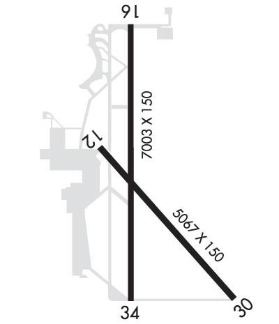
| Rwy | Rwy | |||||||
| 5067x150 | 5067' | 5067x150 | 5067' | |||||
| 7003x150 | 7003' | 7003x150 | 7003' | 108.70 - 346° | ||||
| Runway ID | Single Wheel | Double Wheel | Double Tandem Wheel | Dual Double Wheel |
| 12/30 | 60,000 | 72,000 | 110,000 | N/A |
| 16/34 | 98,000 | 128,000 | 195,000 | N/A |
| These numbers are Advisory and are not limits. The Airport Manager should have more accurate Weight Limits | ||||
 Airport Diagram might not be current. | |
| Facility Name: | REDDING RGNL |
| City Name: | REDDING |
| County: | SHASTA |
| State abbrev: | CA |
| State Name: | CALIFORNIA |
| Ownership: | PUBLICLY OWNED |
| Use: | OPEN TO THE PUBLIC |
| Owner's Name: | CITY OF REDDING |
| Address: | AIRPORTS DIVISION, 6751 WOODRUM CIRCLE, #200 |
| REDDING, CA 96002-6071 | |
| Owner's Phone: | 530-224-4321 |
| Manager's Name: | ANDREW SOLSVIG; EMAIL: ASOLSVIG@CITYOFREDDING.ORG |
| Address: | 6751 WOODRUM, 6751 WOODRUM CIRCLE SUITE 200 |
| REDDING, CA 96002 | |
| Phone: | 530-224-4321 |
| FAA Region: | WESTERN-PACIFIC |
| FAA Field Office: | SFO |
| Date | Sunrise | Sunset |
|---|---|---|
| 02/08/25 Saturday | 7:12 | 17:36 |
| 02/09/25 Sunday | 7:10 | 17:37 |
| 02/10/25 Monday | 7:09 | 17:38 |
| 02/11/25 Tuesday | 7:08 | 17:40 |
| 02/12/25 Wednesday | 7:07 | 17:41 |
| 02/13/25 Thursday | 7:06 | 17:42 |
| 02/14/25 Friday | 7:04 | 17:43 |
| 02/15/25 Saturday | 7:03 | 17:44 |
| 02/16/25 Sunday | 7:02 | 17:46 |
| 02/17/25 Monday | 7:00 | 17:47 |
| 02/18/25 Tuesday | 6:59 | 17:48 |
| 02/19/25 Wednesday | 6:58 | 17:49 |
| 02/20/25 Thursday | 6:56 | 17:50 |
| 02/21/25 Friday | 6:55 | 17:51 |
| Airport Attendance Schedule | CONTINUOUS |
| Airport Status | OPERATIONAL (This Status can change at any time - please check NOTAMS) |
| Airport Lighting Schedule | ACTVT MALSR RWY 34; REIL RWY 16; PAPI RWY 16; HIRL RWY 16/34; MIRL RWY 12/30; TWY LGTS - CTAF. |
| Airport Storage Available | Tie Downs |
| Extra Services Available | Air Ambulance, Avionics, Cargo Handling, Charter, Flight Instruction, Aircraft Rental, Aircraft Sales |
| Wind Indicator | YES - (lighted) |
| Control Tower | YES |
| CTAF Frequency | 119.800 |
| Unicom Frequency | 122.950 |
| Rotating Beacon Color | WG |
| Segmented Circle | YES |
| Landing Fee | NO |
| Airport Inspected | FEDERAL - performed by FAA AIRPORTS FIELD PERSONNEL |
| Inspection Date | 06/28/2024 |
| Type of Fuel Available | Grade 100LL, JET A (freeze point -40C) |
| Airframe Repair Service | MAJOR |
| Power Plant Repair Service | MAJOR |
| Latitude | N4030.5 |
| Longitude | W12217.6 (ESTIMATED) |
| Arpt Elevation | 505ft (SURVEYED) |
| Magnetic Variation | 14E |
| 6 miles SE | of REDDING |
| Traffic Pattern Altitude | |
| Sectional Chart | KLAMATH FALLS |
| Operations (Reported) | Yearly | Avg. Daily |
|---|---|---|
| General Aviation Transient | 0 | 0 |
| General Aviation Local | 0 | 0 |
| Air Taxi | 0 | 0 |
| Commerical | 0 | 0 |
| Commuter | 0 | 0 |
| Military | 0 | 0 |
| Aircraft based on Field | |
|---|---|
| General Aviation Singles | 0 |
| General Aviation Multi | 0 |
| Jet Aircraft | 0 |
| General Aviation Helicopters | 0 |
| Military Aircraft | 0 |
| Gliders | 0 |
| Ultralights | 0 |
| FSS on field | NO |
| FSS tie-in | RANCHO MURIETA |
| FSS Phone | 1-800-WX-BRIEF |
| Who issues Notams | RDD |
| Notam D service at airport | YES |
| ARTCC Name | OAKLAND |
| Airport Certification | AIRPORT RECEIVING SCHEDULED AIR CARRIER SERVICE FROM CARRIERS CERTIFICATED BY THE CIVIL AERONAUTICS BOARD; PPR FOR UNSKED ACR OPNS WITH MORE THAN 30 PSGR SEATS 2130-0630 CALL AMGR (530) 224-4321. |
| Aircraft Rescue & Firefighting Index | AIRPORT HAS A CERTIFICATE UNDER CFR PART 139 |
| Airport of Entry | No |
| Custom Landing Rights | No |
| Joint Civil/Military | No |
| Military Landing rights | YES |
| NATIONAL PLAN OF INTEGRATED AIRPORT SYSTEMS (NPIAS) |
| GRANT AGREEMENTS UNDER FAAP/ADAP/AIP |
| SURPLUS PROPERTY AGREEMENT UNDER PUBLIC LAW 289 |
| SURPLUS PROPERTY AGREEMENT UNDER REGULATION 16-WAA |
| ADVANCE PLANNING AGREEMENT UNDER FAAP |
| ASSURANCES PURSUANT TO TITLE VI, CIVIL RIGHTS ACT OF 1964 |
| U.S. FOREST SERVICE ON FLD, EXPECT HEAVY AIR TANKER ACTIVITY DURING FIRE SEASON. |
| FIELD CONDITIONS RWY; APNS & TWYS GOOD TO FAIR. |
| FOR NOISE ABATEMENT AVOID OVERFLIGHTS OF RESIDENTIAL HOUSING WHEN POSSIBLE. |
| USE CTN BIRDS INVOF ARPT. |
| FOR CD IF UNA TO CTC ON FSS FREQ, CTC OAKLAND ARTCC AT 510-745-3380. |
| RWY 12/3 0 PCR VALUE: 350/F/C/X/T |
| RWY 16/3 4 PCR VALUE: 500/F/B/X/T |
Airport Communications & Frequencies:
| |||||||||||||||||
| Runway: 12 | Runway: 30 | ||
| Mag heading: | 126° | Mag heading: | 306° |
| Rwy Slope: | -.15% Down | Rwy Slope: | .15% Up |
| Approach: | Approach: | ||
| Pattern: | Left Traffic | Pattern: | Left Traffic |
| Markings: | BASIC | Markings: | BASIC |
| Marking Condition: | GOOD | Marking Condition: | GOOD |
| Arresting Dev: | Arresting Dev: | ||
| Lat & Long: | N4030.7 W12217.8 | Lat. & Long.: | N4030.1 W12217.1 |
| Elev: | 500.0 ft. MSL | Elev: | 492.3 ft. MSL |
| TCH: | TCH: | 32 ft. AGL | |
| Visual Glide Path: | Visual Glide Path: | 3.00 degrees | |
| Displaced Threshold: | No | Displaced Threshold: | No |
| Touchdown Zone: | YES | Touchdown Zone: | YES |
| Touchdown Elev.: | 500.1 feet | Touchdown Elev.: | 497.6 feet |
| Visual Glide Slope: | Visual Glide Slope: | 2-Light PAPI on LEFT side of Runway | |
| RVR Equipment: | RVR Equipment: | ||
| RVV Equipment: | NO | RVV Equipment: | NO |
| Approach Lights: | Approach Lights: | ||
| REIL: | NO | REIL: | NO |
| Centerline Lights: | NO | Centerline Lights: | NO |
| Touchdown lights: | NO | Touchdown lights: | NO |
| Runway Category: | Runway with a Visual Approach | Runway Category: | Runway with a Visual Approach |
| Declared Distances: | TORA:5067' TODA:5067' ASDA:5067' LDA:5067' | Declared Distances: | TORA:5067' TODA:5067' ASDA:5067' LDA:5067' |
| Obstructions: | TREES | Obstructions: | TREE |
| Marked: | NOT Marked/Lighted | Marked: | NOT Marked/Lighted |
| Clearance slope: | 21:1 | Clearance slope: | 21:1 |
| Obstruction height: | 65 feet AGL | Obstruction height: | 88 feet AGL |
| Dist. from runway: | 1600 feet | Dist. from runway: | 2075 feet |
| Centerline offset: | 300 right of centerline | Centerline offset: | 275 feet right of centerline |
| Comments: | Comments: |
| Runway: 16 | Runway: 34 | ||
| Mag heading: | 166° | Mag heading: | 346° |
| Rwy Slope: | -.20% Down | Rwy Slope: | .20% Up |
| Approach: | Approach: | ILS/DME | |
| Pattern: | Left Traffic | Pattern: | Left Traffic |
| Markings: | PRECISION INSTRUMENT | Markings: | PRECISION INSTRUMENT |
| Marking Condition: | GOOD | Marking Condition: | GOOD |
| Arresting Dev: | Arresting Dev: | ||
| Lat & Long: | N4031.2 W12217.7 | Lat. & Long.: | N4030.1 W12217.7 |
| Elev: | 504.8 ft. MSL | Elev: | 490.7 ft. MSL |
| TCH: | 40 ft. AGL | TCH: | 55 ft. AGL |
| Visual Glide Path: | 3.43 degrees | Visual Glide Path: | 3.00 degrees |
| Displaced Threshold: | No | Displaced Threshold: | No |
| Touchdown Zone: | YES | Touchdown Zone: | YES |
| Touchdown Elev.: | 505.0 feet | Touchdown Elev.: | 499.0 feet |
| Visual Glide Slope: | 4-Light PAPI on LEFT side of Runway | Visual Glide Slope: | 4-Light PAPI on LEFT side of Runway |
| RVR Equipment: | RVR Equipment: | ||
| RVV Equipment: | NO | RVV Equipment: | NO |
| Approach Lights: | Approach Lights: | MALSR - 1,400 foot medium intensity approach lighting system with runway alignment indicator lights | |
| REIL: | YES | REIL: | NO |
| Centerline Lights: | NO | Centerline Lights: | NO |
| Touchdown lights: | NO | Touchdown lights: | NO |
| Runway Category: | Runway with a Non-precision Approach having visibility minimums greater than 3/4 mile | Runway Category: | Precision Instrument Runway |
| Declared Distances: | TORA:7003' TODA:7003' ASDA:6997' LDA:6997' | Declared Distances: | TORA:7003' TODA:7003' ASDA:6997' LDA:6997' |
| Obstructions: | TREE | Obstructions: | |
| Marked: | NOT Marked/Lighted | Marked: | |
| Clearance slope: | 34:1 | Clearance slope: | 50:1 |
| Obstruction height: | 44 feet AGL | Obstruction height: | |
| Dist. from runway: | 1700 feet | Dist. from runway: | |
| Centerline offset: | 650 right of centerline | Centerline offset: | |
| Comments: | Comments: |
Thanks for using FltPlan.com
all rights reserved © 1999-2025 by Flight Plan LLC