
| READING REGIONAL/SPAATZ READING PA |
| |
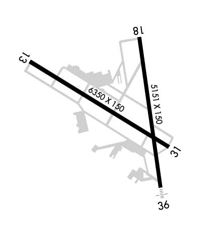
| Lat: N 4022.7 Long: W 07557.9 Elev: 343 Var: +12 Longest Runway: 6350 | ||
| Dept. ATIS: 127.1 Arr. ATIS: 127.1 AWOS: 127.1 Ground: 121.9 Tower: 119.9 | ||
| |||||||||||||||||||||||||||||||||||||||||||||||||||||||||||||||||||||
| |||||||||||||||||||||||||||||||||||||||||||||||||||||||||||||||||||||
| |||||||||||||||||||||||||||||||||||||||||||||||||||||||||||||||||||||
| |||||||||||||||||||||||||||||||||||||||||||||||||||||||||||||||||||||
| |||||||||||||||||||||||||||||||||||||||||||||||||||||||||||||||||||||
| Rwy | Rwy | |||||||
| 6350x150 | 6350' | 110.55 - 133° | 6350x150 | 6350' | ||||
| 5151x150 | 5151' | 5151x150 | 5151' | 109.50 - 004° | ||||
| Runway ID | Single Wheel | Double Wheel | Double Tandem Wheel | Dual Double Wheel |
| 13/31 | 75,000 | 200,000 | 400,000 | N/A |
| 18/36 | 75,000 | 200,000 | 400,000 | N/A |
| These numbers are Advisory and are not limits. The Airport Manager should have more accurate Weight Limits | ||||
 Airport Diagram might not be current. | |
| Facility Name: | READING RGNL/CARL A SPAATZ FLD |
| City Name: | READING |
| County: | BERKS |
| State abbrev: | PA |
| State Name: | PENNSYLVANIA |
| Ownership: | PUBLICLY OWNED |
| Use: | OPEN TO THE PUBLIC |
| Owner's Name: | READING REGIONAL ARPT AUTH. |
| Address: | 2501 BERNVILLE RD |
| READING, PA 19605 | |
| Owner's Phone: | 610-372-4666 |
| Manager's Name: | TERRY P. SROKA |
| Address: | 2501 BERNVILLE RD |
| READING, PA 19605 | |
| Phone: | 610-372-4666 |
| FAA Region: | EASTERN |
| FAA Field Office: | HAR |
| Date | Sunrise | Sunset |
|---|---|---|
| 09/24/21 Friday | 6:53 | 18:58 |
| 09/25/21 Saturday | 6:54 | 18:56 |
| 09/26/21 Sunday | 6:55 | 18:55 |
| 09/27/21 Monday | 6:56 | 18:53 |
| 09/28/21 Tuesday | 6:57 | 18:51 |
| 09/29/21 Wednesday | 6:58 | 18:50 |
| 09/30/21 Thursday | 6:59 | 18:48 |
| 10/01/21 Friday | 7:00 | 18:46 |
| 10/02/21 Saturday | 7:01 | 18:45 |
| 10/03/21 Sunday | 7:02 | 18:43 |
| 10/04/21 Monday | 7:03 | 18:42 |
| 10/05/21 Tuesday | 7:04 | 18:40 |
| 10/06/21 Wednesday | 7:05 | 18:38 |
| 10/07/21 Thursday | 7:06 | 18:37 |
| Airport Attendance Schedule | 7 Days A Week 0600-2300 |
| Airport Status | OPERATIONAL (This Status can change at any time - please check NOTAMS) |
| Airport Lighting Schedule | WHEN ATCT CLSD ACTVT MALSF RWY 36; REIL RWY 13, 31; PAPI RWY 13 & 18; HIRL RWY 13/31 & 18/36; TWY LGTS - CTAF. |
| Airport Storage Available | Tie Downs, Hanger |
| Extra Services Available | Air Freight, Air Ambulance, Avionics, Cargo Handling, Charter, Flight Instruction, Aircraft Rental, Aircraft Sales |
| Wind Indicator | YES - (lighted) |
| Control Tower | YES |
| CTAF Frequency | 119.900 |
| Unicom Frequency | 122.950 |
| Rotating Beacon Color | CLEAR-GREEN (Light Land Airport) |
| Segmented Circle | NO |
| Landing Fee | YES; LNDG FEE FOR TURBINE ACFT. |
| Airport Inspected | FEDERAL - performed by FAA AIRPORTS FIELD PERSONNEL |
| Inspection Date | 04/06/2021 |
| Type of Fuel Available | Grade 100LL, JET A (freeze point -40C) |
| Airframe Repair Service | MAJOR |
| Power Plant Repair Service | MAJOR |
| Latitude | N4022.7 |
| Longitude | W07557.9 (ESTIMATED) |
| Arpt Elevation | 343ft (SURVEYED) |
| Magnetic Variation | 12W |
| 3 miles NW | of READING |
| Traffic Pattern Altitude | |
| Sectional Chart | NEW YORK |
| Operations (Reported) | Yearly | Avg. Daily |
|---|---|---|
| General Aviation Transient | 13335 | 37 |
| General Aviation Local | 8610 | 24 |
| Air Taxi | 1963 | 5 |
| Commerical | 4 | 0 |
| Commuter | 0 | 0 |
| Military | 386 | 1 |
| Aircraft based on Field | |
|---|---|
| General Aviation Singles | 64 |
| General Aviation Multi | 17 |
| Jet Aircraft | 12 |
| General Aviation Helicopters | 3 |
| Military Aircraft | 0 |
| Gliders | 1 |
| Ultralights | 0 |
| FSS on field | NO |
| FSS tie-in | WILLIAMSPORT |
| FSS Phone | 1-800-WX-BRIEF |
| Who issues Notams | RDG |
| Notam D service at airport | YES |
| ARTCC Name | NEW YORK |
| Airport Certification | PPR 24 HRS FOR ACFT OPNS WITH MORE THAN 30 PAX SEATS. CALL AMGR 610-372-4666. |
| Aircraft Rescue & Firefighting Index | AIRPORT HAS A CERTIFICATE UNDER CFR PART 139 |
| Airport of Entry | No |
| Custom Landing Rights | No |
| Joint Civil/Military | No |
| Military Landing rights | YES |
| NATIONAL PLAN OF INTEGRATED AIRPORT SYSTEMS (NPIAS) |
| GRANT AGREEMENTS UNDER FAAP/ADAP/AIP |
| SURPLUS PROPERTY AGREEMENT UNDER REGULATION 16-WAA |
| ASSURANCES PURSUANT TO TITLE VI, CIVIL RIGHTS ACT OF 1964 |
| BIRDS & DEER ON & INVOF ARPT. |
| FOR CD WHEN ATCT CLSD, CTC HARRISBURG APCH AT 800-932-0712. |
Airport Communications & Frequencies:
| |||||||||||||||||||||||||||||||||||||
| Runway: 13 | Runway: 31 | ||
| Mag heading: | 133° | Mag heading: | 313° |
| Rwy Slope: | -.22% Down | Rwy Slope: | .22% Up |
| Approach: | ILS/DME | Approach: | |
| Pattern: | Left Traffic | Pattern: | Left Traffic |
| Markings: | PRECISION INSTRUMENT | Markings: | PRECISION INSTRUMENT |
| Marking Condition: | GOOD | Marking Condition: | GOOD |
| Arresting Dev: | EMAS; ARRESTING GEAR/SYSTEM: ENGINEERED MATERIAL ARRESTING SYSTEM (EMAS) 255 FT IN LENGTH BY 170 FT IN WIDTH LOCATED AT DEP END RWY 13. | Arresting Dev: | |
| Lat & Long: | N4023.0 W07558.7 | Lat. & Long.: | N4022.5 W07557.5 |
| Elev: | 343.4 ft. MSL | Elev: | 329.7 ft. MSL |
| TCH: | 45 ft. AGL | TCH: | |
| Visual Glide Path: | 3.00 degrees | Visual Glide Path: | |
| Displaced Threshold: | No | Displaced Threshold: | No |
| Touchdown Zone: | YES | Touchdown Zone: | YES |
| Touchdown Elev.: | 343.4 feet | Touchdown Elev.: | 329.7 feet |
| Visual Glide Slope: | 4-Light PAPI on LEFT side of Runway; PAPI UNUSBL BYD 3 DEGS LEFT OF CNTRLN. | Visual Glide Slope: | |
| RVR Equipment: | RVR Equipment: | ||
| RVV Equipment: | NO | RVV Equipment: | NO |
| Approach Lights: | Approach Lights: | ||
| REIL: | YES | REIL: | YES |
| Centerline Lights: | NO | Centerline Lights: | NO |
| Touchdown lights: | NO | Touchdown lights: | NO |
| Runway Category: | Precision Instrument Runway | Runway Category: | Runway with a Visual Approach |
| Declared Distances: | TORA:6350' TODA:6350' ASDA:6350' LDA:6350' | Declared Distances: | TORA:6350' TODA:6350' ASDA:6350' LDA:6350' |
| Obstructions: | TREES | Obstructions: | TREE |
| Marked: | NOT Marked/Lighted | Marked: | NOT Marked/Lighted |
| Clearance slope: | 23:1 | Clearance slope: | 16:1 |
| Obstruction height: | 315 feet AGL | Obstruction height: | 28 feet AGL |
| Dist. from runway: | 7661 feet | Dist. from runway: | 648 feet |
| Centerline offset: | 1213 left of centerline | Centerline offset: | 262 feet left of centerline |
| Comments: | Comments: |
| Runway: 18 | Runway: 36 | ||
| Mag heading: | 184° | Mag heading: | 4° |
| Rwy Slope: | 1.01% Up | Rwy Slope: | -1.01% Down |
| Approach: | Approach: | ILS | |
| Pattern: | Left Traffic | Pattern: | Left Traffic |
| Markings: | PRECISION INSTRUMENT | Markings: | PRECISION INSTRUMENT |
| Marking Condition: | GOOD | Marking Condition: | GOOD |
| Arresting Dev: | Arresting Dev: | ||
| Lat & Long: | N4023.1 W07557.8 | Lat. & Long.: | N4022.2 W07557.6 |
| Elev: | 290.4 ft. MSL | Elev: | 342.3 ft. MSL |
| TCH: | 56 ft. AGL | TCH: | |
| Visual Glide Path: | 3.00 degrees | Visual Glide Path: | |
| Displaced Threshold: | No | Displaced Threshold: | No |
| Touchdown Zone: | YES | Touchdown Zone: | YES |
| Touchdown Elev.: | 318.4 feet | Touchdown Elev.: | 343.3 feet |
| Visual Glide Slope: | 4-Light PAPI on LEFT side of Runway | Visual Glide Slope: | |
| RVR Equipment: | RVR Equipment: | TOUCHDOWN | |
| RVV Equipment: | NO | RVV Equipment: | YES |
| Approach Lights: | Approach Lights: | MALSF - 1,400 foot medium intensity approach lighting system with sequenced flashers | |
| REIL: | NO | REIL: | NO |
| Centerline Lights: | NO | Centerline Lights: | NO |
| Touchdown lights: | NO | Touchdown lights: | NO |
| Runway Category: | Runway with a Non-precision Approach having visibility minimums greater than 3/4 mile | Runway Category: | Precision Instrument Runway |
| Declared Distances: | TORA:5151' TODA:5151' ASDA:5151' LDA:5151' | Declared Distances: | TORA:5151' TODA:5151' ASDA:5151' LDA:5151' |
| Obstructions: | TREES | Obstructions: | TREES |
| Marked: | NOT Marked/Lighted | Marked: | NOT Marked/Lighted |
| Clearance slope: | 12:1 | Clearance slope: | 33:1 |
| Obstruction height: | 55 feet AGL | Obstruction height: | 31 feet AGL |
| Dist. from runway: | 893 feet | Dist. from runway: | 1229 feet |
| Centerline offset: | 580 right of centerline | Centerline offset: | 216 feet right of centerline |
| Comments: | Comments: |
Thanks for using FltPlan.com
all rights reserved © 1999-2021 by Flight Plan LLC


