| ROSS COUNTY CHILLICOTHE OH |
| |
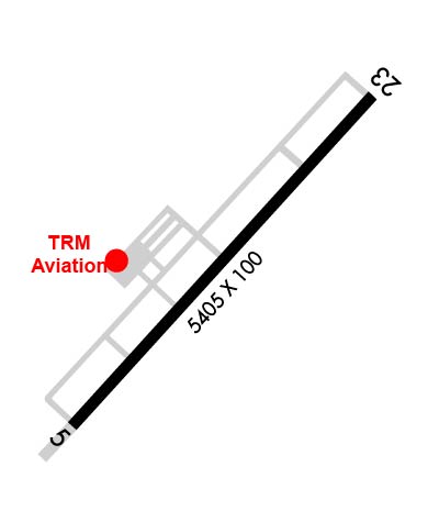
| Lat: N 3926.4 Long: W 08301.4 Elev: 725 Var: +05 Longest Runway: 5405 | ||
| AWOS: 119.22 CTAF: 122.8 | ||
| ||||||||||||||||||||||||||||||||||||||||||||||||||||||||||||||
| ||||||||||||||||||||||||||||||||||||||||||||||||||||||||||||||
| ||||||||||||||||||||||||||||||||||||||||||||||||||||||||||||||
| Rwy | Rwy | |||||||
| 5405x100 | 5405' | 5405x100 | 5405' | |||||
| Runway ID | Single Wheel | Double Wheel | Double Tandem Wheel | Dual Double Wheel |
| 05/23 | 75,000 | 100,000 | N/A | N/A |
| These numbers are Advisory and are not limits. The Airport Manager should have more accurate Weight Limits | ||||
 Airport Diagram might not be current. | |
| Facility Name: | ROSS COUNTY |
| City Name: | CHILLICOTHE |
| County: | ROSS |
| State abbrev: | OH |
| State Name: | OHIO |
| Ownership: | PUBLICLY OWNED |
| Use: | OPEN TO THE PUBLIC |
| Owner's Name: | ROSS COUNTY BOARD OF COMM |
| Address: | 2 N PAINT ST STE H |
| CHILLICOTHE, OH 45601-3109 | |
| Owner's Phone: | 740-702-3085 |
| Manager's Name: | JAMES PARKS |
| Address: | 1296 STONE RD; ADNL CTC: TRM@HORIZONVIEW.NET. |
| CHILLICOTHE, OH 45601-9739 | |
| Phone: | 740-773-4788 |
| FAA Region: | GREAT LAKES |
| FAA Field Office: | DET |
| Date | Sunrise | Sunset |
|---|---|---|
| 09/24/21 Friday | 7:21 | 19:26 |
| 09/25/21 Saturday | 7:22 | 19:25 |
| 09/26/21 Sunday | 7:23 | 19:23 |
| 09/27/21 Monday | 7:24 | 19:21 |
| 09/28/21 Tuesday | 7:25 | 19:20 |
| 09/29/21 Wednesday | 7:26 | 19:18 |
| 09/30/21 Thursday | 7:27 | 19:17 |
| 10/01/21 Friday | 7:28 | 19:15 |
| 10/02/21 Saturday | 7:29 | 19:13 |
| 10/03/21 Sunday | 7:30 | 19:12 |
| 10/04/21 Monday | 7:31 | 19:10 |
| 10/05/21 Tuesday | 7:32 | 19:09 |
| 10/06/21 Wednesday | 7:33 | 19:07 |
| 10/07/21 Thursday | 7:34 | 19:06 |
| Airport Attendance Schedule | 7 Days A Week 0800-1700; UNATNDD: NEW YEAR, JULY 4TH, THANKSGIVING, & CHRISTMAS. |
| Airport Status | OPERATIONAL (This Status can change at any time - please check NOTAMS) |
| Airport Lighting Schedule | ACTVT REIL RWY 05 & 23; PAPI RWY 05 & 23; MIRL RWY 05/23 - 123.0. |
| Airport Storage Available | Tie Downs, Hanger |
| Extra Services Available | Avionics, Charter, Flight Instruction, Aircraft Rental, Aircraft Sales |
| Wind Indicator | YES - (lighted) |
| Control Tower | NO |
| CTAF Frequency | 122.800 |
| Unicom Frequency | 122.800 |
| Rotating Beacon Color | CLEAR-GREEN (Light Land Airport) |
| Segmented Circle | NO |
| Landing Fee | NO |
| Airport Inspected | STATE - performed by STATE AERONAUTICAL PERSONNEL |
| Inspection Date | 09/07/2018 |
| Type of Fuel Available | Grade 100LL, JET A (freeze point -40C) |
| Airframe Repair Service | MINOR |
| Power Plant Repair Service | MINOR |
| Latitude | N3926.4 |
| Longitude | W08301.4 (ESTIMATED) |
| Arpt Elevation | 725ft (SURVEYED) |
| Magnetic Variation | 05W |
| 6 miles NW | of CHILLICOTHE |
| Traffic Pattern Altitude | |
| Sectional Chart | CINCINNATI |
| Operations (Reported) | Yearly | Avg. Daily |
|---|---|---|
| General Aviation Transient | 9600 | 26 |
| General Aviation Local | 39600 | 108 |
| Air Taxi | 550 | 2 |
| Commerical | 0 | 0 |
| Commuter | 0 | 0 |
| Military | 4000 | 11 |
| Aircraft based on Field | |
|---|---|
| General Aviation Singles | 24 |
| General Aviation Multi | 0 |
| Jet Aircraft | 1 |
| General Aviation Helicopters | 0 |
| Military Aircraft | 0 |
| Gliders | 0 |
| Ultralights | 0 |
| FSS on field | NO |
| FSS tie-in | DAYTON |
| FSS Phone | 1-800-WX-BRIEF |
| Who issues Notams | DAY |
| Notam D service at airport | YES |
| ARTCC Name | INDIANAPOLIS |
| Airport Certification | |
| Aircraft Rescue & Firefighting Index | None |
| Airport of Entry | No |
| Custom Landing Rights | No |
| Joint Civil/Military | No |
| Military Landing rights | YES |
| NATIONAL PLAN OF INTEGRATED AIRPORT SYSTEMS (NPIAS) |
| GRANT AGREEMENTS UNDER FAAP/ADAP/AIP |
| ASSURANCES PURSUANT TO TITLE VI, CIVIL RIGHTS ACT OF 1964 |
| FOR CD CTC COLUMBUS APCH AT 614-338-8537. |
| OCNL DEER, BIRDS, & OTR WILDLIFE ON & INVOF ARPT. |
Airport Communications & Frequencies:
| ||||||||||||||||||||
| Runway: 05 | Runway: 23 | ||
| Mag heading: | 47° | Mag heading: | 227° |
| Rwy Slope: | -.38% Down | Rwy Slope: | .38% Up |
| Approach: | Approach: | ||
| Pattern: | Left Traffic | Pattern: | Left Traffic |
| Markings: | NONPRECISION INSTRUMENT | Markings: | NONPRECISION INSTRUMENT |
| Marking Condition: | GOOD | Marking Condition: | GOOD |
| Arresting Dev: | Arresting Dev: | ||
| Lat & Long: | N3926.1 W08301.8 | Lat. & Long.: | N3926.8 W08301.0 |
| Elev: | 724.9 ft. MSL | Elev: | 704.5 ft. MSL |
| TCH: | 44 ft. AGL | TCH: | 45 ft. AGL |
| Visual Glide Path: | 3.00 degrees | Visual Glide Path: | 3.00 degrees |
| Displaced Threshold: | No | Displaced Threshold: | No |
| Touchdown Zone: | YES | Touchdown Zone: | YES |
| Touchdown Elev.: | 725.0 feet | Touchdown Elev.: | 716.3 feet |
| Visual Glide Slope: | 4-Light PAPI on LEFT side of Runway | Visual Glide Slope: | 4-Light PAPI on LEFT side of Runway |
| RVR Equipment: | RVR Equipment: | ||
| RVV Equipment: | NO | RVV Equipment: | NO |
| Approach Lights: | Approach Lights: | ||
| REIL: | YES | REIL: | YES |
| Centerline Lights: | NO | Centerline Lights: | NO |
| Touchdown lights: | NO | Touchdown lights: | NO |
| Runway Category: | Runway with a Visual Approach | Runway Category: | Runway with a Non-precision Approach having visibility minimums greater than 3/4 mile |
| Declared Distances: | Declared Distances: | ||
| Obstructions: | TREES | Obstructions: | TREES |
| Marked: | NOT Marked/Lighted | Marked: | NOT Marked/Lighted |
| Clearance slope: | 20:1 | Clearance slope: | 23:1 |
| Obstruction height: | 75 feet AGL | Obstruction height: | 45 feet AGL |
| Dist. from runway: | 1735 feet | Dist. from runway: | 1240 feet |
| Centerline offset: | 215 left of centerline | Centerline offset: | 315 feet left of centerline |
| Comments: | Comments: |
Thanks for using FltPlan.com
all rights reserved © 1999-2021 by Flight Plan LLC