| SHENANDOAH MUNI SHENANDOAH IA |
| |
| Lat: N 4045.1 Long: W 09524.8 Elev: 971 Var: -05 Longest Runway: 5000 | ||
| AWOS: 125.52 CTAF: 122.8 | ||
| |||||||||||||||||||||||
| |||||||||||||||||||||||
| |||||||||||||||||||||||
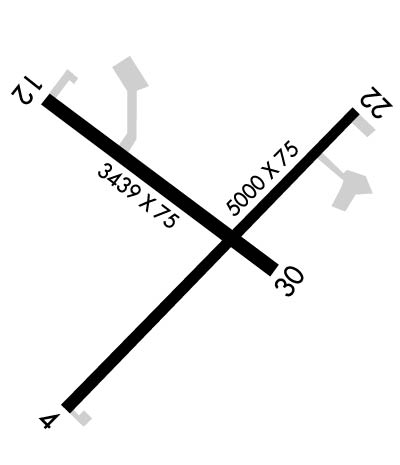
| Rwy | Rwy | |||||||
| 5000x75 | 5000' | 5000x75 | 5000' | |||||
| 3439x75 | 3439' | 3439x75 | 3439' | |||||
| Runway ID | Single Wheel | Double Wheel | Double Tandem Wheel | Dual Double Wheel |
| 04/22 | 30,000 | 38,000 | N/A | N/A |
| 12/30 | 4,000 | N/A | N/A | N/A |
| These numbers are Advisory and are not limits. The Airport Manager should have more accurate Weight Limits | ||||
 Airport Diagram might not be current. | |
| Facility Name: | SHENANDOAH MUNI |
| City Name: | SHENANDOAH |
| County: | FREMONT |
| State abbrev: | IA |
| State Name: | IOWA |
| Ownership: | PUBLICLY OWNED |
| Use: | OPEN TO THE PUBLIC |
| Owner's Name: | CITY OF SHENANDOAH; AJ LYMAN- CITY MGR PHONE 712-246-4411. |
| Address: | 500 WEST CLARINDA |
| SHENANDOAH, IA 51601 | |
| Owner's Phone: | 712-246-4411 |
| Manager's Name: | RANDY WAGNER |
| Address: | 2033 MANTI ROAD |
| SHENANDOAH, IA 51601 | |
| Phone: | 712-246-1931 |
| FAA Region: | CENTRAL |
| FAA Field Office: | NONE |
| Date | Sunrise | Sunset |
|---|---|---|
| 09/24/21 Friday | 7:11 | 19:16 |
| 09/25/21 Saturday | 7:12 | 19:14 |
| 09/26/21 Sunday | 7:13 | 19:12 |
| 09/27/21 Monday | 7:14 | 19:11 |
| 09/28/21 Tuesday | 7:15 | 19:09 |
| 09/29/21 Wednesday | 7:16 | 19:07 |
| 09/30/21 Thursday | 7:17 | 19:06 |
| 10/01/21 Friday | 7:18 | 19:04 |
| 10/02/21 Saturday | 7:19 | 19:02 |
| 10/03/21 Sunday | 7:20 | 19:01 |
| 10/04/21 Monday | 7:21 | 18:59 |
| 10/05/21 Tuesday | 7:22 | 18:57 |
| 10/06/21 Wednesday | 7:23 | 18:56 |
| 10/07/21 Thursday | 7:24 | 18:54 |
| Airport Attendance Schedule | MON - SAT 0800-1700; FOR ATTENDANT AFT HRS CALL (712) 370-2367. |
| Airport Status | OPERATIONAL (This Status can change at any time - please check NOTAMS) |
| Airport Lighting Schedule | ACTVT MIRL RY 04/22; PAPI RYS 04 & 22; VASI RY 30; REIL RYS 04 & 22 - CTAF. |
| Airport Storage Available | Tie Downs, Hanger |
| Extra Services Available | Crop Dusting |
| Wind Indicator | YES - (lighted) |
| Control Tower | NO |
| CTAF Frequency | 122.800 |
| Unicom Frequency | 122.800 |
| Rotating Beacon Color | CLEAR-GREEN (Light Land Airport) |
| Segmented Circle | YES |
| Landing Fee | NO |
| Airport Inspected | STATE - performed by STATE AERONAUTICAL PERSONNEL |
| Inspection Date | 10/11/2017 |
| Type of Fuel Available | Grade 100LL, JET A |
| Airframe Repair Service | MAJOR |
| Power Plant Repair Service | MAJOR |
| Latitude | N4045.1 |
| Longitude | W09524.8 (ESTIMATED) |
| Arpt Elevation | 971ft (SURVEYED) |
| Magnetic Variation | 05E |
| 3 miles SW | of SHENANDOAH |
| Traffic Pattern Altitude | |
| Sectional Chart | OMAHA |
| Operations (Reported) | Yearly | Avg. Daily |
|---|---|---|
| General Aviation Transient | 1990 | 5 |
| General Aviation Local | 1510 | 4 |
| Air Taxi | 0 | 0 |
| Commerical | 0 | 0 |
| Commuter | 0 | 0 |
| Military | 0 | 0 |
| Aircraft based on Field | |
|---|---|
| General Aviation Singles | 16 |
| General Aviation Multi | 0 |
| Jet Aircraft | 0 |
| General Aviation Helicopters | 0 |
| Military Aircraft | 0 |
| Gliders | 0 |
| Ultralights | 0 |
| FSS on field | NO |
| FSS tie-in | FORT DODGE |
| FSS Phone | 1-800-WX-BRIEF |
| Who issues Notams | SDA |
| Notam D service at airport | YES |
| ARTCC Name | MINNEAPOLIS |
| Airport Certification | |
| Aircraft Rescue & Firefighting Index | None |
| Airport of Entry | No |
| Custom Landing Rights | No |
| Joint Civil/Military | No |
| Military Landing rights | YES |
| NATIONAL PLAN OF INTEGRATED AIRPORT SYSTEMS (NPIAS) |
| GRANT AGREEMENTS UNDER FAAP/ADAP/AIP |
| ASSURANCES PURSUANT TO TITLE VI, CIVIL RIGHTS ACT OF 1964 |
| RY 22 IS CALM WIND RY. |
| FOR CD CTC OMAHA APCH AT 402-682-4395. |
Airport Communications & Frequencies:
| ||||||||||||||
| Runway: 04 | Runway: 22 | ||
| Mag heading: | 38° | Mag heading: | 218° |
| Rwy Slope: | .14% Up | Rwy Slope: | -.14% Down |
| Approach: | Approach: | ||
| Pattern: | Left Traffic | Pattern: | Left Traffic |
| Markings: | NONPRECISION INSTRUMENT | Markings: | NONPRECISION INSTRUMENT |
| Marking Condition: | FAIR | Marking Condition: | FAIR |
| Arresting Dev: | Arresting Dev: | ||
| Lat & Long: | N4044.7 W09525.1 | Lat. & Long.: | N4045.3 W09524.4 |
| Elev: | 960.7 ft. MSL | Elev: | 967.9 ft. MSL |
| TCH: | 35 ft. AGL | TCH: | 33 ft. AGL |
| Visual Glide Path: | 3.00 degrees | Visual Glide Path: | 3.00 degrees |
| Displaced Threshold: | No | Displaced Threshold: | No |
| Touchdown Zone: | YES | Touchdown Zone: | YES |
| Touchdown Elev.: | 966.5 feet | Touchdown Elev.: | 971.1 feet |
| Visual Glide Slope: | 2-Light PAPI on LEFT side of Runway | Visual Glide Slope: | 2-Light PAPI on LEFT side of Runway |
| RVR Equipment: | RVR Equipment: | ||
| RVV Equipment: | NO | RVV Equipment: | NO |
| Approach Lights: | Approach Lights: | ||
| REIL: | YES | REIL: | YES |
| Centerline Lights: | NO | Centerline Lights: | NO |
| Touchdown lights: | NO | Touchdown lights: | NO |
| Runway Category: | Runway with a Non-precision Approach having visibility minimums greater than 3/4 mile | Runway Category: | Runway with a Visual Approach |
| Declared Distances: | Declared Distances: | ||
| Obstructions: | ROAD | Obstructions: | PLINE |
| Marked: | NOT Marked/Lighted | Marked: | MARKED and LIGHTED |
| Clearance slope: | 34:1 | Clearance slope: | 41:1 |
| Obstruction height: | 33 feet AGL | Obstruction height: | 17 feet AGL |
| Dist. from runway: | 1355 feet | Dist. from runway: | 900 feet |
| Centerline offset: | Centerline offset: | ||
| Comments: | Comments: |
| Runway: 12 | Runway: 30 | ||
| Mag heading: | 120° | Mag heading: | 300° |
| Rwy Slope: | .50% Up | Rwy Slope: | -.50% Down |
| Approach: | Approach: | ||
| Pattern: | Left Traffic | Pattern: | Left Traffic |
| Markings: | NONPRECISION INSTRUMENT | Markings: | NONPRECISION INSTRUMENT |
| Marking Condition: | GOOD | Marking Condition: | GOOD |
| Arresting Dev: | Arresting Dev: | ||
| Lat & Long: | N4045.4 W09525.2 | Lat. & Long.: | N4045.0 W09524.6 |
| Elev: | 952.2 ft. MSL | Elev: | 969.4 ft. MSL |
| TCH: | TCH: | 42 ft. AGL | |
| Visual Glide Path: | Visual Glide Path: | 3.50 degrees | |
| Displaced Threshold: | No | Displaced Threshold: | No |
| Touchdown Zone: | YES | Touchdown Zone: | YES |
| Touchdown Elev.: | 963.9 feet | Touchdown Elev.: | 969.4 feet |
| Visual Glide Slope: | Visual Glide Slope: | 4-BOX VASI ON LEFT SIDE OF RUNWAY | |
| RVR Equipment: | RVR Equipment: | ||
| RVV Equipment: | NO | RVV Equipment: | NO |
| Approach Lights: | Approach Lights: | ||
| REIL: | NO | REIL: | NO |
| Centerline Lights: | NO | Centerline Lights: | NO |
| Touchdown lights: | NO | Touchdown lights: | NO |
| Runway Category: | Runway with a Non-precision Approach | Runway Category: | Runway with a Visual Approach |
| Declared Distances: | Declared Distances: | ||
| Obstructions: | TREE | Obstructions: | |
| Marked: | NOT Marked/Lighted | Marked: | |
| Clearance slope: | 9:1 | Clearance slope: | 50:1 |
| Obstruction height: | 26 feet AGL | Obstruction height: | |
| Dist. from runway: | 434 feet | Dist. from runway: | |
| Centerline offset: | 262 left of centerline | Centerline offset: | |
| Comments: | Comments: |
Thanks for using FltPlan.com
all rights reserved © 1999-2021 by Flight Plan LLC