| ABRAHAM LINCOLN CAPITAL SPRINGFIELD IL |
| |
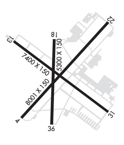
| Lat: N 3950.7 Long: W 08940.7 Elev: 598 Var: +01 Longest Runway: 8001 | ||
| Clr Del: 121.7 Dept. ATIS: 127.65 Arr. ATIS: 127.65 AWOS: 127.65 Ground: 121.9 Tower: 121.3 | ||
| |||||||||||||||||||||||||||||||||||||||||||||||||||||||||||||||||||||
| |||||||||||||||||||||||||||||||||||||||||||||||||||||||||||||||||||||
| |||||||||||||||||||||||||||||||||||||||||||||||||||||||||||||||||||||
| Rwy | Rwy | |||||||
| 8001x150 | 8001' | 109.50 - 042° | 8001x150 | 8001' | 111.70 - 222° | |||
| 7400x150 | 7400' | 7400x150 | 7400' | 110.15 - 307° | ||||
| Runway ID | Single Wheel | Double Wheel | Double Tandem Wheel | Dual Double Wheel |
| 04/22 | 100,000 | 200,000 | 350,000 | N/A |
| 13/31 | 70,000 | 90,000 | 160,000 | N/A |
| These numbers are Advisory and are not limits. The Airport Manager should have more accurate Weight Limits | ||||
 Airport Diagram might not be current. | |
| Facility Name: | ABRAHAM LINCOLN CAPITAL |
| City Name: | SPRINGFIELD |
| County: | SANGAMON |
| State abbrev: | IL |
| State Name: | ILLINOIS |
| Ownership: | PUBLICLY OWNED |
| Use: | OPEN TO THE PUBLIC |
| Owner's Name: | SPRINGFIELD ARPT AUTH |
| Address: | 1200 CAPITAL AIRPORT DR |
| SPRINGFIELD, IL 62707-8489 | |
| Owner's Phone: | 217-788-1080 |
| Manager's Name: | MARK HANNA |
| Address: | CAPITAL AIRPORT |
| SPRINGFIELD, IL 62707-8419 | |
| Phone: | 217-788-1080 |
| FAA Region: | GREAT LAKES |
| FAA Field Office: | CHI |
| Date | Sunrise | Sunset |
|---|---|---|
| 01/18/25 Saturday | 7:17 | 17:02 |
| 01/19/25 Sunday | 7:17 | 17:03 |
| 01/20/25 Monday | 7:16 | 17:04 |
| 01/21/25 Tuesday | 7:16 | 17:05 |
| 01/22/25 Wednesday | 7:15 | 17:06 |
| 01/23/25 Thursday | 7:14 | 17:07 |
| 01/24/25 Friday | 7:14 | 17:09 |
| 01/25/25 Saturday | 7:13 | 17:10 |
| 01/26/25 Sunday | 7:12 | 17:11 |
| 01/27/25 Monday | 7:11 | 17:12 |
| 01/28/25 Tuesday | 7:11 | 17:13 |
| 01/29/25 Wednesday | 7:10 | 17:15 |
| 01/30/25 Thursday | 7:09 | 17:16 |
| 01/31/25 Friday | 7:08 | 17:17 |
| Airport Attendance Schedule | 7 Days A Week 0530-0000 |
| Airport Status | OPERATIONAL (This Status can change at any time - please check NOTAMS) |
| Airport Lighting Schedule | WHEN ATCT CLSD ACTVT HIRL RY 13/31; HIRL RY 04/22; MALSR RYS 04; 22 & 31; VASI RY 31; REIL RY 13 - CTAF. PAPI RY 13 & VASI RYS 04 & 22 OPER CONTINUOUSLY. |
| Airport Storage Available | Tie Downs, Hanger |
| Extra Services Available | Charter, Flight Instruction, Aircraft Rental |
| Wind Indicator | YES - (lighted) |
| Control Tower | YES |
| CTAF Frequency | 121.300 |
| Unicom Frequency | 122.950 |
| Rotating Beacon Color | WG |
| Segmented Circle | NO |
| Landing Fee | NO |
| Airport Inspected | FEDERAL - performed by FAA AIRPORTS FIELD PERSONNEL |
| Inspection Date | 10/22/2024 |
| Type of Fuel Available | Grade 100LL, JET A (freeze point -40C)J8 |
| Airframe Repair Service | MAJOR |
| Power Plant Repair Service | MAJOR |
| Latitude | N3950.7 |
| Longitude | W08940.7 (ESTIMATED) |
| Arpt Elevation | 597ft (SURVEYED) |
| Magnetic Variation | 01W |
| 3 miles NW | of SPRINGFIELD |
| Traffic Pattern Altitude | |
| Sectional Chart | ST LOUIS |
| Operations (Reported) | Yearly | Avg. Daily |
|---|---|---|
| General Aviation Transient | 0 | 0 |
| General Aviation Local | 0 | 0 |
| Air Taxi | 0 | 0 |
| Commerical | 0 | 0 |
| Commuter | 0 | 0 |
| Military | 0 | 0 |
| Aircraft based on Field | |
|---|---|
| General Aviation Singles | 0 |
| General Aviation Multi | 0 |
| Jet Aircraft | 0 |
| General Aviation Helicopters | 0 |
| Military Aircraft | 0 |
| Gliders | 0 |
| Ultralights | 0 |
| FSS on field | NO |
| FSS tie-in | SAINT LOUIS |
| FSS Phone | 1-800-WX-BRIEF |
| Who issues Notams | SPI |
| Notam D service at airport | YES |
| ARTCC Name | KANSAS CITY |
| Airport Certification | AIRPORT RECEIVING SCHEDULED AIR CARRIER SERVICE FROM CARRIERS CERTIFICATED BY THE CIVIL AERONAUTICS BOARD; ARFF UNAVBL FOR UNSKED ACFT OPS 0600-1130Z++ DLY EXC WITH PPR, CALL 217-788-1080. |
| Aircraft Rescue & Firefighting Index | AIRPORT HAS A CERTIFICATE UNDER CFR PART 139 |
| Airport of Entry | No |
| Custom Landing Rights | No |
| Joint Civil/Military | No |
| Military Landing rights | YES |
| NATIONAL PLAN OF INTEGRATED AIRPORT SYSTEMS (NPIAS) |
| GRANT AGREEMENTS UNDER FAAP/ADAP/AIP |
| ASSURANCES PURSUANT TO TITLE VI, CIVIL RIGHTS ACT OF 1964 |
| AGREEMENT UNDER DLAND OR DCLA HAS EXPIRED. |
| GENERAL AVIATION ACCESS TO & PARKING ON THE ACR RAMP IS PROHIBITED. |
| WX SVC AVBL H24. |
| DURING SNOW REMOVAL OPS EQUIPMENT OPERATORS WILL MONITOR CTAF WHEN THE TWR IS CLSD. |
| DASSP GATEWAY ARPT CALL 217-788-1080. |
| FOR CD IF UNA TO CTC ON FSS FREQ, CTC ST LOUIS APCH AT 314-890-1017. |
| 100LL SELF SERVE AVBL 24HRS. |
| TWY Y1, TWY Y2, AND TWY Y BTN TWY Y1 AND TWY A NOT AVBL FOR AIR CARRIER OPS WITH MORE THAN 9 PAX SEATS. |
| (OVERRUN LEN, RWY 22) 150 FT WIDTH. |
| RWY 04/2 2 PCR VALUE: 830/R/C/W/T |
| RWY 13/3 1 PCR VALUE: 830/F/C/X/T |
Airport Communications & Frequencies:
| |||||||||||||||||||||||||||||||||||||||||||
| Runway: 04 | Runway: 22 | ||
| Mag heading: | 43° | Mag heading: | 223° |
| Rwy Slope: | .13% Up | Rwy Slope: | -.13% Down |
| Approach: | ILS | Approach: | ILS |
| Pattern: | Left Traffic | Pattern: | Left Traffic |
| Markings: | PRECISION INSTRUMENT | Markings: | PRECISION INSTRUMENT |
| Marking Condition: | GOOD | Marking Condition: | GOOD |
| Arresting Dev: | Arresting Dev: | ||
| Lat & Long: | N3950.2 W08941.2 | Lat. & Long.: | N3951.2 W08940.1 |
| Elev: | 587.5 ft. MSL | Elev: | 597.7 ft. MSL |
| TCH: | 56 ft. AGL | TCH: | 54 ft. AGL |
| Visual Glide Path: | 3.00 degrees | Visual Glide Path: | 3.00 degrees |
| Displaced Threshold: | No | Displaced Threshold: | No |
| Touchdown Zone: | YES | Touchdown Zone: | YES |
| Touchdown Elev.: | 592.2 feet | Touchdown Elev.: | 597.8 feet |
| Visual Glide Slope: | 4-BOX VASI ON LEFT SIDE OF RUNWAY | Visual Glide Slope: | 4-BOX VASI ON LEFT SIDE OF RUNWAY |
| RVR Equipment: | TOUCHDOWN | RVR Equipment: | ROLLOUT |
| RVV Equipment: | NO | RVV Equipment: | NO |
| Approach Lights: | MALSR - 1,400 foot medium intensity approach lighting system with runway alignment indicator lights | Approach Lights: | MALSR - 1,400 foot medium intensity approach lighting system with runway alignment indicator lights |
| REIL: | NO | REIL: | NO |
| Centerline Lights: | NO | Centerline Lights: | NO |
| Touchdown lights: | NO | Touchdown lights: | NO |
| Runway Category: | Precision Instrument Runway | Runway Category: | Precision Instrument Runway |
| Declared Distances: | TORA:8001' TODA:8001' ASDA:7927' LDA:7927' | Declared Distances: | TORA:8001' TODA:8001' ASDA:8001' LDA:8001' |
| Obstructions: | TREE | Obstructions: | TREE |
| Marked: | NOT Marked/Lighted | Marked: | NOT Marked/Lighted |
| Clearance slope: | 41:1 | Clearance slope: | 49:1 |
| Obstruction height: | 49 feet AGL | Obstruction height: | 78 feet AGL |
| Dist. from runway: | 2239 feet | Dist. from runway: | 4040 feet |
| Centerline offset: | 758 right of centerline | Centerline offset: | 704 feet right of centerline |
| Comments: | Comments: |
| Runway: 13 | Runway: 31 | ||
| Mag heading: | 128° | Mag heading: | 308° |
| Rwy Slope: | -.06% Down | Rwy Slope: | .06% Up |
| Approach: | Approach: | ILS | |
| Pattern: | Left Traffic | Pattern: | Left Traffic |
| Markings: | PRECISION INSTRUMENT | Markings: | PRECISION INSTRUMENT |
| Marking Condition: | GOOD | Marking Condition: | GOOD |
| Arresting Dev: | Arresting Dev: | ||
| Lat & Long: | N3951.0 W08941.3 | Lat. & Long.: | N3950.3 W08940.1 |
| Elev: | 587.8 ft. MSL | Elev: | 583.1 ft. MSL |
| TCH: | 50 ft. AGL | TCH: | 54 ft. AGL |
| Visual Glide Path: | 3.00 degrees | Visual Glide Path: | 3.00 degrees |
| Displaced Threshold: | No | Displaced Threshold: | No |
| Touchdown Zone: | YES | Touchdown Zone: | YES |
| Touchdown Elev.: | 591.7 feet | Touchdown Elev.: | 589.8 feet |
| Visual Glide Slope: | 4-Light PAPI on RIGHT side of Runway | Visual Glide Slope: | 4-BOX VASI ON LEFT SIDE OF RUNWAY |
| RVR Equipment: | RVR Equipment: | ||
| RVV Equipment: | NO | RVV Equipment: | NO |
| Approach Lights: | Approach Lights: | MALSR - 1,400 foot medium intensity approach lighting system with runway alignment indicator lights | |
| REIL: | YES | REIL: | NO |
| Centerline Lights: | NO | Centerline Lights: | NO |
| Touchdown lights: | NO | Touchdown lights: | NO |
| Runway Category: | Runway with a Non-precision Approach having visibility minimums greater than 3/4 mile | Runway Category: | Precision Instrument Runway |
| Declared Distances: | TORA:7400' TODA:7400' ASDA:7217' LDA:7217' | Declared Distances: | TORA:7400' TODA:7400' ASDA:7000' LDA:7000' |
| Obstructions: | TREES | Obstructions: | TREE |
| Marked: | NOT Marked/Lighted | Marked: | NOT Marked/Lighted |
| Clearance slope: | 39:1 | Clearance slope: | 42:1 |
| Obstruction height: | 74 feet AGL | Obstruction height: | 22 feet AGL |
| Dist. from runway: | 3131 feet | Dist. from runway: | 1142 feet |
| Centerline offset: | 383 right of centerline | Centerline offset: | 628 feet left of centerline |
| Comments: | Comments: |
Thanks for using FltPlan.com
all rights reserved © 1999-2025 by Flight Plan LLC