| SIOUX GATEWAY/COL. BUD DAY FIE SIOUX CITY IA |
| |
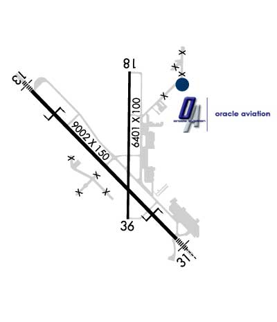
| Lat: N 4224.1 Long: W 09623.1 Elev: 1098 Var: -03 Longest Runway: 9002 | ||
| Dept. ATIS: 119.45 Arr. ATIS: 119.45 AWOS: 119.45 Ground: 121.9 Tower: 118.7 | ||
| |||||||||||||||||||||||||||||||||||||||
| |||||||||||||||||||||||||||||||||||||||
| |||||||||||||||||||||||||||||||||||||||
| |||||||||||||||||||||||||||||||||||||||
| FBOs at nearby airports who want your business: | |||||||||||||||||
| |||||||||||||||||
| Rwy | Rwy | |||||||
| 9002x150 | 9002' | 111.30 - 132° | 9002x150 | 9002' | 109.30 - 312° | |||
| 6401x100 | 6401' | 6401x100 | 6401' | |||||
| Runway ID | Single Wheel | Double Wheel | Double Tandem Wheel | Dual Double Wheel |
| 13/31 | 100,000 | 120,000 | 220,000 | N/A |
| 18/36 | 65,000 | 80,000 | 130,000 | N/A |
| These numbers are Advisory and are not limits. The Airport Manager should have more accurate Weight Limits | ||||
 Airport Diagram might not be current. | |
| Facility Name: | SIOUX GATEWAY/BRIG GENERAL BUD DAY FLD |
| City Name: | SIOUX CITY |
| County: | WOODBURY |
| State abbrev: | IA |
| State Name: | IOWA |
| Ownership: | PUBLICLY OWNED |
| Use: | OPEN TO THE PUBLIC |
| Owner's Name: | SIOUX GATEWAY AIRPORT |
| Address: | 2403 AVIATION BLVD. |
| SIOUX CITY, IA 51111 | |
| Owner's Phone: | 712-279-0167 |
| Manager's Name: | MR. ALVIN LORENZO |
| Address: | 2403 AVIATION BLVD. |
| SIOUX CITY, IA 51111 | |
| Phone: | 720-365-6312 |
| FAA Region: | CENTRAL |
| FAA Field Office: | NONE |
| Date | Sunrise | Sunset |
|---|---|---|
| 04/24/25 Thursday | 6:31 | 20:17 |
| 04/25/25 Friday | 6:29 | 20:18 |
| 04/26/25 Saturday | 6:28 | 20:19 |
| 04/27/25 Sunday | 6:27 | 20:21 |
| 04/28/25 Monday | 6:25 | 20:22 |
| 04/29/25 Tuesday | 6:24 | 20:23 |
| 04/30/25 Wednesday | 6:22 | 20:24 |
| 05/01/25 Thursday | 6:21 | 20:25 |
| 05/02/25 Friday | 6:20 | 20:26 |
| 05/03/25 Saturday | 6:18 | 20:27 |
| 05/04/25 Sunday | 6:17 | 20:28 |
| 05/05/25 Monday | 6:16 | 20:29 |
| 05/06/25 Tuesday | 6:14 | 20:31 |
| 05/07/25 Wednesday | 6:13 | 20:32 |
| Airport Attendance Schedule | MON-SUN 0500-2200 |
| Airport Status | OPERATIONAL (This Status can change at any time - please check NOTAMS) |
| Airport Lighting Schedule | DUSK-DAWN. WHEN ATCT CLSD ACTVT MALS RWY 13; MALSR RWY 31; REIL RWY 18; VASI RWY 13 & 31; HIRL RWY 13/31; MIRL RWY 18/36 - CTAF. |
| Airport Storage Available | Tie Downs, Hanger |
| Extra Services Available | Air Freight, Air Ambulance, Charter, Flight Instruction, Aircraft Rental, Aircraft Sales, Annual Surveying |
| Wind Indicator | YES - (lighted) |
| Control Tower | YES |
| CTAF Frequency | 118.700 |
| Unicom Frequency | 122.950 |
| Rotating Beacon Color | WG |
| Segmented Circle | NO |
| Landing Fee | NO |
| Airport Inspected | FEDERAL - performed by FAA AIRPORTS FIELD PERSONNEL |
| Inspection Date | 05/30/2024 |
| Type of Fuel Available | Grade 100LL, JET A (freeze point -40C); -A FOR FUEL AND SUPPORT AFT HRS BY PPR OR CALL IN. |
| Airframe Repair Service | MAJOR |
| Power Plant Repair Service | MAJOR |
| Latitude | N4224.1 |
| Longitude | W09623.1 (ESTIMATED) |
| Arpt Elevation | 1098ft (SURVEYED) |
| Magnetic Variation | 03E |
| 6 miles S | of SIOUX CITY |
| Traffic Pattern Altitude | |
| Sectional Chart | OMAHA |
| Operations (Reported) | Yearly | Avg. Daily |
|---|---|---|
| General Aviation Transient | 0 | 0 |
| General Aviation Local | 0 | 0 |
| Air Taxi | 0 | 0 |
| Commerical | 0 | 0 |
| Commuter | 0 | 0 |
| Military | 0 | 0 |
| Aircraft based on Field | |
|---|---|
| General Aviation Singles | 0 |
| General Aviation Multi | 0 |
| Jet Aircraft | 0 |
| General Aviation Helicopters | 0 |
| Military Aircraft | 0 |
| Gliders | 0 |
| Ultralights | 0 |
| FSS on field | NO |
| FSS tie-in | FORT DODGE |
| FSS Phone | 1-800-WX-BRIEF |
| Who issues Notams | SUX |
| Notam D service at airport | YES |
| ARTCC Name | MINNEAPOLIS |
| Airport Certification | AIRPORT RECEIVING SCHEDULED AIR CARRIER SERVICE FROM CARRIERS CERTIFICATED BY THE CIVIL AERONAUTICS BOARD; ARFF INDEX D FIRE FIGHTING EQUIPTMENT AVBL ON REQUEST. |
| Aircraft Rescue & Firefighting Index | AIRPORT HAS A CERTIFICATE UNDER CFR PART 139 |
| Airport of Entry | No |
| Custom Landing Rights | No |
| Joint Civil/Military | No |
| Military Landing rights | YES |
| NATIONAL PLAN OF INTEGRATED AIRPORT SYSTEMS (NPIAS) |
| GRANT AGREEMENTS UNDER FAAP/ADAP/AIP |
| SURPLUS PROPERTY AGREEMENT UNDER PUBLIC LAW 289 |
| ASSURANCES PURSUANT TO TITLE VI, CIVIL RIGHTS ACT OF 1964 |
| (E60-13) BAK12/14 LCTD 1392' FROM THR. |
| PAEW 2130-0600 DURING INCLEMENT WEATHER NOV-APR. |
| CTN: OCNL BIRDWATCH COND - SEV DRG SPRING/FALL DUE TO MIGRATORY WATERFOWL. CIVILIAN TWR DOES NOT BROADCAST USAF BIRDWATCH COND. CTC AFLD MGMT FOR BIRD STS. |
| RY 31 IS CALM WIND RY. |
| SERVICE-FLUID: LPOX & LHNIT. |
| SERVICE-JASU: 6(A/M32A-86) 6(A/M32-95). |
| APCH END RWY 31 - BAK-12(B)/14 LCTD (1492'). |
| AFLD SURFACE CONDITIONS NOT MONITORED BY ARPT MANAGEMENT BTN 0000 - 0400 LCL DAILY. |
| RSTD: ALL MIL OPS OPR 1300-2200Z++ TUE-FRI EXC HOL. |
| SERVICE-OIL: JOAP- AVBL ONLY DUR ANG DUTY HR. |
| CAUTION: PORTIONS OF TWY A SE OF TWY B NOT VIS BY TWR. |
| FUEL: A++ |
| ATCT HAS LIMITED VISIBILITY OF TWY A NEAR ARFF BLDG AND OF TWY G. |
| FOR CD IF UNA TO CTC ON FSS FREQ, CTC MINNEAPOLIS ARTCC AT 651-463-5588. |
| APCH END RY 13 - BAK-12/14(B) LCTD(1500'). |
| PPR FOR USE OF ANG RAMP V(712)-233-0210. |
| ANG RMRKS: OFFL BUS ONLY/PPR. COMMAND POST (24 HR OPN) DSN 585-0211 OR 585-0212 OR C712-233-0211/0212. EXTREMELY LIMITED PARKING. TRANS ACFT PAX IDENT & BAGGAGE SEARCH UNAVBL.BASE OPS OPR 1230-2230Z++ TUE-FRI EXC HOL. C712-233-0276 DSN 585-0276. |
Airport Communications & Frequencies:
| |||||||||||||||||||||||||||||||
| Runway: 13 | Runway: 31 | ||
| Mag heading: | 133° | Mag heading: | 313° |
| Rwy Slope: | .00% Up | Rwy Slope: | .00% Down |
| Approach: | ILS | Approach: | ILS/DME |
| Pattern: | Left Traffic | Pattern: | Left Traffic |
| Markings: | PRECISION INSTRUMENT | Markings: | PRECISION INSTRUMENT |
| Marking Condition: | GOOD | Marking Condition: | GOOD |
| Arresting Dev: | BAK-12; BAK-14 BAK-12B(B) (1392'). | Arresting Dev: | BAK-12; BAK-14 BAK-12B(B) (1492'). |
| Lat & Long: | N4224.6 W09623.9 | Lat. & Long.: | N4223.5 W09622.5 |
| Elev: | 1093.1 ft. MSL | Elev: | 1093.4 ft. MSL |
| TCH: | 50 ft. AGL | TCH: | 51 ft. AGL |
| Visual Glide Path: | 3.00 degrees | Visual Glide Path: | 3.00 degrees |
| Displaced Threshold: | No | Displaced Threshold: | No |
| Touchdown Zone: | YES | Touchdown Zone: | YES |
| Touchdown Elev.: | 1094.7 feet | Touchdown Elev.: | 1096.5 feet |
| Visual Glide Slope: | 4-BOX VASI ON LEFT SIDE OF RUNWAY | Visual Glide Slope: | 4-BOX VASI ON LEFT SIDE OF RUNWAY |
| RVR Equipment: | TOUCHDOWN-ROLLOUT | RVR Equipment: | TOUCHDOWN-ROLLOUT |
| RVV Equipment: | NO | RVV Equipment: | NO |
| Approach Lights: | MALS - 1,400 foot medium intensity approach lighting system | Approach Lights: | MALSR - 1,400 foot medium intensity approach lighting system with runway alignment indicator lights |
| REIL: | NO | REIL: | NO |
| Centerline Lights: | NO | Centerline Lights: | NO |
| Touchdown lights: | NO | Touchdown lights: | NO |
| Runway Category: | Precision Instrument Runway | Runway Category: | Precision Instrument Runway |
| Declared Distances: | TORA:9002' TODA:9002' ASDA:9002' LDA:9002' | Declared Distances: | TORA:9002' TODA:9002' ASDA:9002' LDA:9002' |
| Obstructions: | TREE | Obstructions: | |
| Marked: | NOT Marked/Lighted | Marked: | |
| Clearance slope: | 40:1 | Clearance slope: | 50:1 |
| Obstruction height: | 72 feet AGL | Obstruction height: | |
| Dist. from runway: | 3100 feet | Dist. from runway: | |
| Centerline offset: | 475 left of centerline | Centerline offset: | |
| Comments: | Comments: |
| Runway: 18 | Runway: 36 | ||
| Mag heading: | 178° | Mag heading: | 358° |
| Rwy Slope: | -.04% Down | Rwy Slope: | .04% Up |
| Approach: | Approach: | ||
| Pattern: | Left Traffic | Pattern: | Left Traffic |
| Markings: | NONPRECISION INSTRUMENT | Markings: | NONPRECISION INSTRUMENT |
| Marking Condition: | FAIR | Marking Condition: | FAIR |
| Arresting Dev: | Arresting Dev: | ||
| Lat & Long: | N4224.7 W09622.9 | Lat. & Long.: | N4223.6 W09622.9 |
| Elev: | 1097.6 ft. MSL | Elev: | 1095.3 ft. MSL |
| TCH: | 54 ft. AGL | TCH: | 54 ft. AGL |
| Visual Glide Path: | 3.00 degrees | Visual Glide Path: | 3.00 degrees |
| Displaced Threshold: | No | Displaced Threshold: | No |
| Touchdown Zone: | YES | Touchdown Zone: | YES |
| Touchdown Elev.: | 1098.5 feet | Touchdown Elev.: | 1097.0 feet |
| Visual Glide Slope: | 4-Light PAPI on RIGHT side of Runway | Visual Glide Slope: | 4-Light PAPI on LEFT side of Runway |
| RVR Equipment: | RVR Equipment: | ||
| RVV Equipment: | NO | RVV Equipment: | NO |
| Approach Lights: | Approach Lights: | ||
| REIL: | YES | REIL: | NO |
| Centerline Lights: | NO | Centerline Lights: | NO |
| Touchdown lights: | NO | Touchdown lights: | NO |
| Runway Category: | Runway with a Non-precision Approach having visibility minimums greater than 3/4 mile | Runway Category: | Runway with a Non-precision Approach having visibility minimums greater than 3/4 mile |
| Declared Distances: | TORA:6400' TODA:6400' ASDA:6400' LDA:6400' | Declared Distances: | TORA:6400' TODA:6400' ASDA:6400' LDA:6400' |
| Obstructions: | TREES | Obstructions: | POLE |
| Marked: | NOT Marked/Lighted | Marked: | NOT Marked/Lighted |
| Clearance slope: | 20:1 | Clearance slope: | 43:1 |
| Obstruction height: | 47 feet AGL | Obstruction height: | 16 feet AGL |
| Dist. from runway: | 1160 feet | Dist. from runway: | 900 feet |
| Centerline offset: | 350 right of centerline | Centerline offset: | |
| Comments: | Comments: |
Thanks for using FltPlan.com
all rights reserved © 1999-2025 by Flight Plan LLC