
| SALINE COUNTY RGNL BENTON AR |
| |
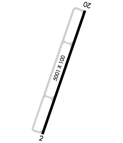
| Lat: N 3435.4 Long: W 09228.8 Elev: 389 Var: -01 Longest Runway: 5002 | ||
| AWOS: 132.12 CTAF: 122.8 | ||
| ||||||||||||||||||||||||||||||||||||||||||||||||||||||||||||||||||||
| ||||||||||||||||||||||||||||||||||||||||||||||||||||||||||||||||||||
| ||||||||||||||||||||||||||||||||||||||||||||||||||||||||||||||||||||
| Rwy | Rwy | |||||||
| 5002x100 | 5002' | 111.95 - 018° | 5002x100 | 5002' | ||||
| Runway ID | Single Wheel | Double Wheel | Double Tandem Wheel | Dual Double Wheel |
| 02/20 | 54,000 | 65,000 | 111,000 | N/A |
| These numbers are Advisory and are not limits. The Airport Manager should have more accurate Weight Limits | ||||
 Airport Diagram might not be current. | |
| Facility Name: | SALINE COUNTY RGNL |
| City Name: | BENTON |
| County: | SALINE |
| State abbrev: | AR |
| State Name: | ARKANSAS |
| Ownership: | PUBLICLY OWNED |
| Use: | OPEN TO THE PUBLIC |
| Owner's Name: | SALINE COUNTY |
| Address: | 200 N MAIN ST |
| BENTON, AR 72015 | |
| Owner's Phone: | 501-303-5690 |
| Manager's Name: | AJ AMBORT |
| Address: | 1100 HILL FARM ROAD |
| BRYANT, AR 72022 | |
| Phone: | (501) 672-9809 |
| FAA Region: | SOUTHWEST |
| FAA Field Office: | AOK |
| Date | Sunrise | Sunset |
|---|---|---|
| 04/18/25 Friday | 6:35 | 19:44 |
| 04/19/25 Saturday | 6:34 | 19:45 |
| 04/20/25 Sunday | 6:32 | 19:46 |
| 04/21/25 Monday | 6:31 | 19:47 |
| 04/22/25 Tuesday | 6:30 | 19:47 |
| 04/23/25 Wednesday | 6:29 | 19:48 |
| 04/24/25 Thursday | 6:28 | 19:49 |
| 04/25/25 Friday | 6:27 | 19:50 |
| 04/26/25 Saturday | 6:25 | 19:51 |
| 04/27/25 Sunday | 6:24 | 19:51 |
| 04/28/25 Monday | 6:23 | 19:52 |
| 04/29/25 Tuesday | 6:22 | 19:53 |
| 04/30/25 Wednesday | 6:21 | 19:54 |
| 05/01/25 Thursday | 6:20 | 19:55 |
| Airport Attendance Schedule | MON-FRI 0800-1630; SELF SERVE 100LL & JET A AVBL 24/7, FOR SVC AFTER HOURS CALL 501-672-9809 CALL OUT FEE |
| Airport Status | OPERATIONAL (This Status can change at any time - please check NOTAMS) |
| Airport Lighting Schedule | ACTVT REIL RWYS 02 & 20; MIRL RWY 02/20 - CTAF. |
| Airport Storage Available | Tie Downs |
| Extra Services Available | Flight Instruction, Aircraft Rental |
| Wind Indicator | YES - (lighted) |
| Control Tower | NO |
| CTAF Frequency | 122.800 |
| Unicom Frequency | 122.800 |
| Rotating Beacon Color | WG |
| Segmented Circle | YES |
| Landing Fee |
| Airport Inspected | STATE - performed by STATE AERONAUTICAL PERSONNEL |
| Inspection Date | 11/29/2023 |
| Type of Fuel Available | Grade 100LL, JET A; -10SELF SVC FUEL AVBL 24 HRS WITH CREDIT CARD. |
| Airframe Repair Service | MINOR |
| Power Plant Repair Service | MAJOR |
| Latitude | N3435.4 |
| Longitude | W09228.8 (ESTIMATED) |
| Arpt Elevation | 389ft (ESTIMATED) |
| Magnetic Variation | 01E |
| 5 miles E | of BENTON |
| Traffic Pattern Altitude | |
| Sectional Chart | MEMPHIS |
| Operations (Reported) | Yearly | Avg. Daily |
|---|---|---|
| General Aviation Transient | 0 | 0 |
| General Aviation Local | 0 | 0 |
| Air Taxi | 0 | 0 |
| Commerical | 0 | 0 |
| Commuter | 0 | 0 |
| Military | 0 | 0 |
| Aircraft based on Field | |
|---|---|
| General Aviation Singles | 0 |
| General Aviation Multi | 0 |
| Jet Aircraft | 0 |
| General Aviation Helicopters | 0 |
| Military Aircraft | 0 |
| Gliders | 0 |
| Ultralights | 0 |
| FSS on field | NO |
| FSS tie-in | JONESBORO |
| FSS Phone | 1-800-WX-BRIEF |
| Who issues Notams | JBR |
| Notam D service at airport | YES |
| ARTCC Name | MEMPHIS |
| Airport Certification | |
| Aircraft Rescue & Firefighting Index | None |
| Airport of Entry | No |
| Custom Landing Rights | No |
| Joint Civil/Military | No |
| Military Landing rights | No |
| NATIONAL PLAN OF INTEGRATED AIRPORT SYSTEMS (NPIAS) |
| GRANT AGREEMENTS UNDER FAAP/ADAP/AIP |
| OBLIGATIONS ASSUMED BY TRANSFER |
| COURTESY CAR AVBL. AFT HRS, CTC AMGR FOR TRML BLDG ENTRY CODE. |
| FOR CD CTC LITTLE ROCK APCH 501-379-2908 OR LITTLE ROCK ATCT 501-379-2911. |
Airport Communications & Frequencies:
| ||||||||||||||
| Runway: 02 | Runway: 20 | ||
| Mag heading: | 19° | Mag heading: | 199° |
| Rwy Slope: | -.04% Down | Rwy Slope: | .04% Up |
| Approach: | ILS/DME | Approach: | |
| Pattern: | Right Traffic | Pattern: | Left Traffic |
| Markings: | NONPRECISION INSTRUMENT | Markings: | NONPRECISION INSTRUMENT |
| Marking Condition: | GOOD | Marking Condition: | GOOD |
| Arresting Dev: | Arresting Dev: | ||
| Lat & Long: | N3435.0 W09228.9 | Lat. & Long.: | N3435.8 W09228.6 |
| Elev: | 389.4 ft. MSL | Elev: | 387.5 ft. MSL |
| TCH: | 56 ft. AGL | TCH: | 63 ft. AGL |
| Visual Glide Path: | 3.00 degrees | Visual Glide Path: | 3.00 degrees |
| Displaced Threshold: | No | Displaced Threshold: | No |
| Touchdown Zone: | YES | Touchdown Zone: | YES |
| Touchdown Elev.: | 389.4 feet | Touchdown Elev.: | 387.6 feet |
| Visual Glide Slope: | 4-Light PAPI on LEFT side of Runway | Visual Glide Slope: | 4-Light PAPI on LEFT side of Runway |
| RVR Equipment: | RVR Equipment: | ||
| RVV Equipment: | NO | RVV Equipment: | NO |
| Approach Lights: | Approach Lights: | ||
| REIL: | YES | REIL: | YES |
| Centerline Lights: | NO | Centerline Lights: | NO |
| Touchdown lights: | NO | Touchdown lights: | NO |
| Runway Category: | Precision Instrument Runway | Runway Category: | Runway with a Non-precision Approach having visibility minimums greater than 3/4 mile |
| Declared Distances: | Declared Distances: | ||
| Obstructions: | TREES | Obstructions: | TREE |
| Marked: | NOT Marked/Lighted | Marked: | NOT Marked/Lighted |
| Clearance slope: | 38:1 | Clearance slope: | 26:1 |
| Obstruction height: | 38 feet AGL | Obstruction height: | 30 feet AGL |
| Dist. from runway: | 1650 feet | Dist. from runway: | 980 feet |
| Centerline offset: | Centerline offset: | 575 feet right of centerline | |
| Comments: | Comments: |
Thanks for using FltPlan.com
all rights reserved © 1999-2025 by Flight Plan LLC


