
| SUMMERSVILLE SUMMERSVILLE WV |
| |
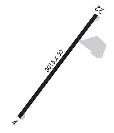
| Lat: N 3813.9 Long: W 08052.2 Elev: 1820 Var: +07 Longest Runway: 3015 | ||
| AWOS: 119.57 CTAF: 122.8 | ||
| ||||||||||||||||||||||||||||||||
| ||||||||||||||||||||||||||||||||
| ||||||||||||||||||||||||||||||||
| Rwy | Rwy | |||||||
| 3015x50 | 3015' | 110.10 - 039° | 3015x50 | 3015' | ||||
| Runway ID | Single Wheel | Double Wheel | Double Tandem Wheel | Dual Double Wheel |
| 04/22 | N/A | N/A | N/A | N/A |
| These numbers are Advisory and are not limits. The Airport Manager should have more accurate Weight Limits | ||||
 Airport Diagram might not be current. | |
| Facility Name: | SUMMERSVILLE |
| City Name: | SUMMERSVILLE |
| County: | NICHOLAS |
| State abbrev: | WV |
| State Name: | WEST VIRGINIA |
| Ownership: | PUBLICLY OWNED |
| Use: | OPEN TO THE PUBLIC |
| Owner's Name: | U.S. ARMY CORPS OF ENGINEERS.; ARPT LEASED TO NICHOLAS CO. ARPT AUTH. P O BOX 95, SUMMERSVILLE, WV 26651. 304-872-7830. USACE POC TRAVIS BOWMAN. 304-590-9353 CELL PH. |
| Address: | 502 8TH ST. |
| HUNTINGTON, WV 25701 | |
| Owner's Phone: | 304-399-5890 |
| Manager's Name: | TIM ADKINS |
| Address: | ATTN: NCAA, PO BOX 95; ARPT PHYS ADDR. 2506 AIRPORT RD. SUMMERSVILLE, WV 26651. |
| SUMMERSVILLE, WV 26651-0754 | |
| Phone: | 304-881-1600 |
| FAA Region: | EASTERN |
| FAA Field Office: | BKW |
| Date | Sunrise | Sunset |
|---|---|---|
| 03/01/25 Saturday | 6:56 | 18:17 |
| 03/02/25 Sunday | 6:54 | 18:18 |
| 03/03/25 Monday | 6:53 | 18:19 |
| 03/04/25 Tuesday | 6:52 | 18:20 |
| 03/05/25 Wednesday | 6:50 | 18:21 |
| 03/06/25 Thursday | 6:49 | 18:22 |
| 03/07/25 Friday | 6:47 | 18:23 |
| 03/08/25 Saturday | 6:46 | 18:24 |
| 03/09/25 Sunday | 7:44 | 19:25 |
| 03/10/25 Monday | 7:43 | 19:26 |
| 03/11/25 Tuesday | 7:41 | 19:27 |
| 03/12/25 Wednesday | 7:40 | 19:28 |
| 03/13/25 Thursday | 7:38 | 19:29 |
| 03/14/25 Friday | 7:37 | 19:30 |
| Airport Attendance Schedule | MON-FRI 0800-1700 |
| Airport Status | OPERATIONAL (This Status can change at any time - please check NOTAMS) |
| Airport Lighting Schedule | ACTVT MIRL RWY 04/22 - CTAF. PAPI RWY 22 OTS INDFLY.; LIGHTHOUSE 2 MI SE. MAY BE MISTAKEN FOR RTG BCN. |
| Airport Storage Available | Tie Downs |
| Extra Services Available | NONE |
| Wind Indicator | YES - (lighted) |
| Control Tower | NO |
| CTAF Frequency | 122.800 |
| Unicom Frequency | 122.800 |
| Rotating Beacon Color | WG |
| Segmented Circle | NO |
| Landing Fee | NO |
| Airport Inspected | STATE - performed by PRIVATE CONTRACT PERSONNEL |
| Inspection Date | 07/11/2023 |
| Type of Fuel Available | Grade 100LL; -10SELF-SERVE. |
| Airframe Repair Service | NONE |
| Power Plant Repair Service | NONE |
| Latitude | N3813.9 |
| Longitude | W08052.2 (ESTIMATED) |
| Arpt Elevation | 1819ft (SURVEYED) |
| Magnetic Variation | 07W |
| 3 miles S | of SUMMERSVILLE |
| Traffic Pattern Altitude | |
| Sectional Chart | CINCINNATI |
| Operations (Reported) | Yearly | Avg. Daily |
|---|---|---|
| General Aviation Transient | 0 | 0 |
| General Aviation Local | 0 | 0 |
| Air Taxi | 0 | 0 |
| Commerical | 0 | 0 |
| Commuter | 0 | 0 |
| Military | 0 | 0 |
| Aircraft based on Field | |
|---|---|
| General Aviation Singles | 0 |
| General Aviation Multi | 0 |
| Jet Aircraft | 0 |
| General Aviation Helicopters | 0 |
| Military Aircraft | 0 |
| Gliders | 0 |
| Ultralights | 0 |
| FSS on field | NO |
| FSS tie-in | ELKINS |
| FSS Phone | 1-800-WX-BRIEF |
| Who issues Notams | EKN |
| Notam D service at airport | YES |
| ARTCC Name | INDIANAPOLIS |
| Airport Certification | |
| Aircraft Rescue & Firefighting Index | None |
| Airport of Entry | No |
| Custom Landing Rights | No |
| Joint Civil/Military | No |
| Military Landing rights | YES |
| NATIONAL PLAN OF INTEGRATED AIRPORT SYSTEMS (NPIAS) |
| THIS AIRPORT HAS BEEN SURVEYED BY THE NATIONAL GEODETIC SURVEY. |
| RWY 04 50 FT DROP-OFF 110 FT FM THR. |
| RWY 22 30 FT DROP-OFF 110 FT FM THR. |
| FOR CD CTC CHARLESTON APCH AT 304-344-5867 EXT 281. |
Airport Communications & Frequencies:
| ||||||||||||||
| Runway: 04 | Runway: 22 | ||
| Mag heading: | 44° | Mag heading: | 224° |
| Rwy Slope: | .40% Up | Rwy Slope: | -.40% Down |
| Approach: | SDF | Approach: | |
| Pattern: | Left Traffic | Pattern: | Left Traffic |
| Markings: | NONPRECISION INSTRUMENT | Markings: | NONPRECISION INSTRUMENT |
| Marking Condition: | FAIR | Marking Condition: | FAIR |
| Arresting Dev: | Arresting Dev: | ||
| Lat & Long: | N3813.7 W08052.4 | Lat. & Long.: | N3814.1 W08052.1 |
| Elev: | 1807.6 ft. MSL | Elev: | 1819.7 ft. MSL |
| TCH: | TCH: | 32 ft. AGL | |
| Visual Glide Path: | Visual Glide Path: | 3.25 degrees | |
| Displaced Threshold: | No | Displaced Threshold: | No |
| Touchdown Zone: | YES | Touchdown Zone: | YES |
| Touchdown Elev.: | 1819.7 feet | Touchdown Elev.: | 1819.7 feet |
| Visual Glide Slope: | Visual Glide Slope: | 2-Light PAPI on LEFT side of Runway | |
| RVR Equipment: | RVR Equipment: | ||
| RVV Equipment: | NO | RVV Equipment: | NO |
| Approach Lights: | Approach Lights: | ||
| REIL: | YES; REILS OTS INDEFLY. | REIL: | YES; REILS OTS INDEFLY. |
| Centerline Lights: | NO | Centerline Lights: | NO |
| Touchdown lights: | NO | Touchdown lights: | NO |
| Runway Category: | Runway with a Non-precision Approach | Runway Category: | Runway with a Non-precision Approach |
| Declared Distances: | Declared Distances: | ||
| Obstructions: | TREES | Obstructions: | TREES |
| Marked: | NOT Marked/Lighted | Marked: | NOT Marked/Lighted |
| Clearance slope: | Clearance slope: | ||
| Obstruction height: | 50 feet AGL | Obstruction height: | 65 feet AGL |
| Dist. from runway: | 201 feet | Dist. from runway: | 201 feet |
| Centerline offset: | 150 right of centerline | Centerline offset: | 150 feet left of centerline |
| Comments: | 30 FT TREES; UP TO 120 FT DSTC, APPROX 105 TO 125 FT RIGHT. | Comments: | 70 FT TREES, 0 FT DSTC 200 FT L. |
Thanks for using FltPlan.com
all rights reserved © 1999-2025 by Flight Plan LLC
