
| ED CARLSON MEMORIAL FIELD TOLEDO WA |
| |
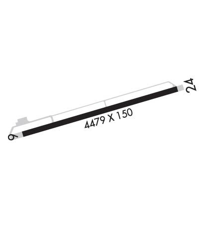
| Lat: N 4628.6 Long: W 12248.4 Elev: 374 Var: -17 Longest Runway: 4479 | ||
| CTAF: 122.9 | ||
| ||||||
|
| Rwy | Rwy | |||||||
| 4479x150 | 4479' | 4479x150 | 4479' | |||||
| Runway ID | Single Wheel | Double Wheel | Double Tandem Wheel | Dual Double Wheel |
| 06/24 | 25,000 | N/A | N/A | N/A |
| These numbers are Advisory and are not limits. The Airport Manager should have more accurate Weight Limits | ||||
 Airport Diagram might not be current. | |
| Facility Name: | ED CARLSON MEML FLD - SOUTH LEWIS COUNTY |
| City Name: | TOLEDO |
| County: | LEWIS |
| State abbrev: | WA |
| State Name: | WASHINGTON |
| Ownership: | PUBLICLY OWNED |
| Use: | OPEN TO THE PUBLIC |
| Owner's Name: | LEWIS COUNTY |
| Address: | 2025 NE KRESKY AVE |
| CHEHALIS, WA 98532 | |
| Owner's Phone: | 360-740-2606 |
| Manager's Name: | JOHN ROE |
| Address: | 5239 JACKSON HWY |
| TOLEDO, WA 98591-9732 | |
| Phone: | 360-864 4966 |
| FAA Region: | NORTHWEST MOUNTAIN |
| FAA Field Office: | SEA |
| Date | Sunrise | Sunset |
|---|---|---|
| 09/24/21 Friday | 7:00 | 19:05 |
| 09/25/21 Saturday | 7:02 | 19:03 |
| 09/26/21 Sunday | 7:03 | 19:01 |
| 09/27/21 Monday | 7:04 | 18:59 |
| 09/28/21 Tuesday | 7:06 | 18:57 |
| 09/29/21 Wednesday | 7:07 | 18:55 |
| 09/30/21 Thursday | 7:08 | 18:53 |
| 10/01/21 Friday | 7:10 | 18:51 |
| 10/02/21 Saturday | 7:11 | 18:49 |
| 10/03/21 Sunday | 7:12 | 18:47 |
| 10/04/21 Monday | 7:14 | 18:45 |
| 10/05/21 Tuesday | 7:15 | 18:44 |
| 10/06/21 Wednesday | 7:16 | 18:42 |
| 10/07/21 Thursday | 7:18 | 18:40 |
| Airport Attendance Schedule | MON-FRI 1000-1700 |
| Airport Status | OPERATIONAL (This Status can change at any time - please check NOTAMS) |
| Airport Lighting Schedule | ACTVT REIL RWY 06 & 24; MIRL RWY 06/24 - CTAF. PAPI RWY 06 & 24 OPR CONSLY. |
| Airport Storage Available | Tie Downs |
| Extra Services Available | Glider, Flight Instruction, Parachute Jumping |
| Wind Indicator | YES - (lighted) |
| Control Tower | NO |
| CTAF Frequency | 122.900 |
| Unicom Frequency | |
| Rotating Beacon Color | CLEAR-GREEN (Light Land Airport) |
| Segmented Circle | NO |
| Landing Fee | NO |
| Airport Inspected | STATE - performed by STATE AERONAUTICAL PERSONNEL |
| Inspection Date | 06/02/2021 |
| Type of Fuel Available | Grade 100LL; -1024 HR CREDIT CARD FUEL FAC. |
| Airframe Repair Service | MINOR |
| Power Plant Repair Service | MINOR |
| Latitude | N4628.6 |
| Longitude | W12248.4 (ESTIMATED) |
| Arpt Elevation | 374ft (SURVEYED) |
| Magnetic Variation | 17E |
| 3 miles N | of TOLEDO |
| Traffic Pattern Altitude | 800 |
| Sectional Chart | SEATTLE |
| Operations (Reported) | Yearly | Avg. Daily |
|---|---|---|
| General Aviation Transient | 5000 | 14 |
| General Aviation Local | 3100 | 8 |
| Air Taxi | 0 | 0 |
| Commerical | 0 | 0 |
| Commuter | 0 | 0 |
| Military | 200 | 1 |
| Aircraft based on Field | |
|---|---|
| General Aviation Singles | 17 |
| General Aviation Multi | 1 |
| Jet Aircraft | 0 |
| General Aviation Helicopters | 0 |
| Military Aircraft | 0 |
| Gliders | 0 |
| Ultralights | 0 |
| FSS on field | NO |
| FSS tie-in | SEATTLE |
| FSS Phone | 1-800-WX-BRIEF |
| Who issues Notams | TDO |
| Notam D service at airport | YES |
| ARTCC Name | SEATTLE |
| Airport Certification | |
| Aircraft Rescue & Firefighting Index | None |
| Airport of Entry | No |
| Custom Landing Rights | No |
| Joint Civil/Military | No |
| Military Landing rights | No |
| NATIONAL PLAN OF INTEGRATED AIRPORT SYSTEMS (NPIAS) |
| AGREEMENT UNDER DLAND OR DCLA HAS EXPIRED. |
| RDO CTL ACFT ADJ RWY 06/24 400 FT S & BLW. |
| DISTANCE TO GO MARKERS SOUTHSIDE OF RY. |
| GLDR ACT JUL-NOV. |
| LNAV GPS APPROACHES CURRENTLY PUBLISHED TO BOTH RUNWAY ENDS, MINIMA AS LOW AS 1 MILE. |
| FOR CD CTC SEATTLE ARTCC AT 253-351-3694. |
Airport Communications & Frequencies:
| |||||||
| Runway: 06 | Runway: 24 | ||
| Mag heading: | 57° | Mag heading: | 237° |
| Rwy Slope: | .41% Up | Rwy Slope: | -.41% Down |
| Approach: | Approach: | ||
| Pattern: | Left Traffic | Pattern: | Left Traffic |
| Markings: | NONPRECISION INSTRUMENT | Markings: | NONPRECISION INSTRUMENT |
| Marking Condition: | GOOD | Marking Condition: | GOOD |
| Arresting Dev: | Arresting Dev: | ||
| Lat & Long: | N4628.5 W12248.9 | Lat. & Long.: | N4628.7 W12247.9 |
| Elev: | 355.5 ft. MSL | Elev: | 374.0 ft. MSL |
| TCH: | 43 ft. AGL | TCH: | 44 ft. AGL |
| Visual Glide Path: | 3.00 degrees | Visual Glide Path: | 3.00 degrees |
| Displaced Threshold: | No | Displaced Threshold: | No |
| Touchdown Zone: | YES | Touchdown Zone: | YES |
| Touchdown Elev.: | 367.1 feet | Touchdown Elev.: | 374.0 feet |
| Visual Glide Slope: | 2-Light PAPI on LEFT side of Runway | Visual Glide Slope: | 2-Light PAPI on LEFT side of Runway |
| RVR Equipment: | RVR Equipment: | ||
| RVV Equipment: | NO | RVV Equipment: | NO |
| Approach Lights: | Approach Lights: | ||
| REIL: | YES | REIL: | YES |
| Centerline Lights: | NO | Centerline Lights: | NO |
| Touchdown lights: | NO | Touchdown lights: | NO |
| Runway Category: | Runway with a Non-precision Approach having visibility minimums greater than 3/4 mile | Runway Category: | Runway with a Non-precision Approach having visibility minimums greater than 3/4 mile |
| Declared Distances: | Declared Distances: | ||
| Obstructions: | TREES | Obstructions: | 4 FT FENCE 300 FT FROM END BOTH SIDES OF CL. |
| Marked: | NOT Marked/Lighted | Marked: | NOT Marked/Lighted |
| Clearance slope: | 25:1 | Clearance slope: | 50:1 |
| Obstruction height: | 100 feet AGL | Obstruction height: | |
| Dist. from runway: | 2723 feet | Dist. from runway: | |
| Centerline offset: | Centerline offset: | ||
| Comments: | Comments: |
Thanks for using FltPlan.com
all rights reserved © 1999-2021 by Flight Plan LLC
