
| HOT SPRINGS CO (CLOSED) THERMOPOLIS WY |
| |
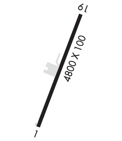
| Lat: N 4339.5 Long: W 10812.8 Elev: 4592 Var: -14 Longest Runway: 4800 | ||
| CTAF: 122.8 | ||
| ||||||||||||||||||||||||||||||||
| ||||||||||||||||||||||||||||||||
| Rwy | Rwy | |||||||
| 4800x100 | 4800' | 4800x100 | 4800' | |||||
| Runway ID | Single Wheel | Double Wheel | Double Tandem Wheel | Dual Double Wheel |
| These numbers are Advisory and are not limits. The Airport Manager should have more accurate Weight Limits | ||||
| FltPlan does not have IFR approaches charts available for KTHP. |
 Airport Diagram might not be current. | |
| Facility Name: | HOT SPRINGS CO-THERMOPOLIS MUNI |
| City Name: | THERMOPOLIS |
| County: | HOT SPRINGS |
| State abbrev: | WY |
| State Name: | WYOMING |
| Ownership: | PUBLICLY OWNED |
| Use: | OPEN TO THE PUBLIC |
| Owner's Name: | HOT SPRINGS COUNTY |
| Address: | BOX 1368 |
| THERMOPOLIS, WY 82443 | |
| Owner's Phone: | 307-864-3515 |
| Manager's Name: | JERRY FIELDS |
| Address: | 704 PARK |
| THERMOPOLIS, WY 82443 | |
| Phone: | (307) 927-9982 |
| FAA Region: | NORTHWEST MOUNTAIN |
| FAA Field Office: | DEN |
| Date | Sunrise | Sunset |
|---|---|---|
| 08/12/17 Saturday | 6:14 | 20:21 |
| 08/13/17 Sunday | 6:15 | 20:20 |
| 08/14/17 Monday | 6:16 | 20:18 |
| 08/15/17 Tuesday | 6:17 | 20:17 |
| 08/16/17 Wednesday | 6:18 | 20:15 |
| 08/17/17 Thursday | 6:19 | 20:14 |
| 08/18/17 Friday | 6:21 | 20:12 |
| 08/19/17 Saturday | 6:22 | 20:11 |
| 08/20/17 Sunday | 6:23 | 20:09 |
| 08/21/17 Monday | 6:24 | 20:07 |
| 08/22/17 Tuesday | 6:25 | 20:06 |
| 08/23/17 Wednesday | 6:26 | 20:04 |
| 08/24/17 Thursday | 6:27 | 20:02 |
| 08/25/17 Friday | 6:28 | 20:01 |
| Airport Attendance Schedule | MAY-SEP 7 Days A Week 0730-1730, OCT-APR 7 Days A Week 0800-1700; FOR AFTER HRS SVC CALL 307-921-9982. CLSD ALL MAJOR HOLIDAYS. |
| Airport Status | OPERATIONAL (This Status can change at any time - please check NOTAMS) |
| Airport Lighting Schedule | ACTVT LIRL RY 01/19 & SAVASI RY 19 - 122.8. |
| Airport Storage Available | Tie Downs, Hanger |
| Extra Services Available | Flight Instruction |
| Wind Indicator | YES - (lighted) |
| Control Tower | NO |
| CTAF Frequency | 122.800 |
| Unicom Frequency | 122.800 |
| Rotating Beacon Color | CLEAR-GREEN (Light Land Airport) |
| Segmented Circle | NO |
| Landing Fee | NO |
| Airport Inspected | STATE - performed by STATE AERONAUTICAL PERSONNEL |
| Inspection Date | 07/07/2015 |
| Type of Fuel Available | Grade 100LL; SELF-SERV CREDIT CARD FUEL AVBL 24 HRS. |
| Airframe Repair Service | NONE |
| Power Plant Repair Service | NONE |
| Latitude | N4339.5 |
| Longitude | W10812.8 (ESTIMATED) |
| Arpt Elevation | 4592ft (ESTIMATED) |
| Magnetic Variation | 14E |
| 1 miles N | of THERMOPOLIS |
| Traffic Pattern Altitude | |
| Sectional Chart | CHEYENNE |
| Operations (Reported) | Yearly | Avg. Daily |
|---|---|---|
| General Aviation Transient | 815 | 2 |
| General Aviation Local | 215 | 1 |
| Air Taxi | 20 | 0 |
| Commerical | 0 | 0 |
| Commuter | 0 | 0 |
| Military | 0 | 0 |
| Aircraft based on Field | |
|---|---|
| General Aviation Singles | 9 |
| General Aviation Multi | 0 |
| Jet Aircraft | 0 |
| General Aviation Helicopters | 0 |
| Military Aircraft | 0 |
| Gliders | 0 |
| Ultralights | 0 |
| FSS on field | NO |
| FSS tie-in | CASPER |
| FSS Phone | 1-800-WX-BRIEF |
| Who issues Notams | CPR |
| Notam D service at airport | YES |
| ARTCC Name | SALT LAKE CITY |
| Airport Certification | |
| Aircraft Rescue & Firefighting Index | None |
| Airport of Entry | No |
| Custom Landing Rights | No |
| Joint Civil/Military | No |
| Military Landing rights | No |
| NATIONAL PLAN OF INTEGRATED AIRPORT SYSTEMS (NPIAS) |
| DUE TO TERRAIN - OPNS AT NIGHT NOT RECOMMENDED. |
| GND DROPS OFF 50 FT AT 15 FT FM RY 01 THLD & 15 FT AT 30 FT FM RY 19 THLD. |
| RY 01/19 IS 118 FT HIGHER ON SOUTH END. RECOMMEND LDG UPHILL RY 19; TKOF DOWNHILL RY 01 DEPENDING ON WIND. |
| (E81) TAXIWAY ENTRANCE LIGHTED. |
| RWY 01/1 9 RY 01/19 +4 FT DIP/TROUGH 137 FT TO 145 FT FROM RY 01 THLD ENTIRE WIDTH OF RY. EXTENSIVE CRACKING AND LINE OF SIGHT ISSUES ON ENTIRE RY. |
| Runway: 01 | Runway: 19 | ||
| Mag heading: | 8° | Mag heading: | 188° |
| Rwy Slope: | -2.47% Down | Rwy Slope: | 2.47% Up |
| Approach: | Approach: | ||
| Pattern: | Left Traffic | Pattern: | Left Traffic |
| Markings: | BASIC | Markings: | BASIC |
| Marking Condition: | FAIR | Marking Condition: | FAIR |
| Arresting Dev: | Arresting Dev: | ||
| Lat & Long: | N4339.4 W10812.8 | Lat. & Long.: | N4340.2 W10812.4 |
| Elev: | 4592.2 ft. MSL | Elev: | 4473.7 ft. MSL |
| TCH: | TCH: | 26 ft. AGL | |
| Visual Glide Path: | Visual Glide Path: | 3.00 degrees | |
| Displaced Threshold: | No | Displaced Threshold: | No |
| Touchdown Zone: | NO | Touchdown Zone: | NO |
| Touchdown Elev.: | Touchdown Elev.: | ||
| Visual Glide Slope: | Visual Glide Slope: | 2-BOX SIMPLIFIED ABBREVIATED VISUAL APPROACH SLOPE INDICATOR ON LEFT SIDE OF RUNWAY | |
| RVR Equipment: | RVR Equipment: | ||
| RVV Equipment: | NO | RVV Equipment: | NO |
| Approach Lights: | Approach Lights: | ||
| REIL: | NO | REIL: | NO |
| Centerline Lights: | NO | Centerline Lights: | NO |
| Touchdown lights: | NO | Touchdown lights: | NO |
| Runway Category: | Runway with a Visual Approach | Runway Category: | Runway with a Visual Approach |
| Declared Distances: | Declared Distances: |
Thanks for using FltPlan.com
all rights reserved © 1999-2017 by Flight Plan LLC
