| TRI-CITIES RGNL TN/VA BRSTL/JHNSN/KNGSPORT TN |
| |
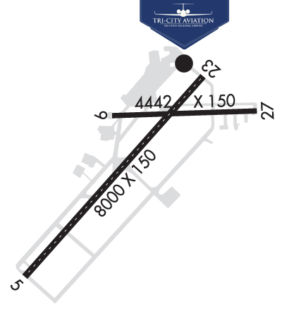
| Lat: N 3628.5 Long: W 08224.4 Elev: 1519 Var: +07 Longest Runway: 8000 | ||
| Dept. ATIS: 118.25 Arr. ATIS: 118.25 Ground: 121.7 Tower: 119.5 | ||
| |||||||||||||||||||||||
| |||||||||||||||||||||||
| |||||||||||||||||||||||
| Rwy | Rwy | |||||||
| 8000x150 | 8000' | 111.50 - 049° | 8000x150 | 8000' | 109.90 - 229° | |||
| 4442x150 | 4442' | 4442x150 | 4315' | |||||
| Runway ID | Single Wheel | Double Wheel | Double Tandem Wheel | Dual Double Wheel |
| 05/23 | 112,000 | 185,000 | 336,000 | N/A |
| 09/27 | 21,500 | N/A | N/A | N/A |
| These numbers are Advisory and are not limits. The Airport Manager should have more accurate Weight Limits | ||||
 Airport Diagram might not be current. | |
| Facility Name: | TRI-CITIES |
| City Name: | BRISTOL/JOHNSON/KINGSPORT |
| County: | SULLIVAN |
| State abbrev: | TN |
| State Name: | TENNESSEE |
| Ownership: | PUBLICLY OWNED |
| Use: | OPEN TO THE PUBLIC |
| Owner's Name: | BRISTOL JOHNSON KINGSPORT; CITIES OF BRISTOL, TN; BRISTOL, VA; JOHNSON CITY & KINGSPORT, TN; COUNTIES OF WASHINGTON & SULLIVAN. TRI CITIES AIRPORT AUTHORITY SETS POLICY AND HAS FINANCIAL AUTHORITY FOR THE AIRPORT. |
| Address: | 2525 HWY 75, SUITE 301 |
| BLOUNTVILLE, TN 37617 | |
| Owner's Phone: | (423) 325-6000 |
| Manager's Name: | GENE COSSEY |
| Address: | 2525 HWY 75, SUITE 301 |
| BLOUNTVILLE, TN 37617 | |
| Phone: | (423) 325-6001 |
| FAA Region: | SOUTHERN |
| FAA Field Office: | MEM |
| Date | Sunrise | Sunset |
|---|---|---|
| 09/24/21 Friday | 7:19 | 19:24 |
| 09/25/21 Saturday | 7:20 | 19:22 |
| 09/26/21 Sunday | 7:20 | 19:21 |
| 09/27/21 Monday | 7:21 | 19:19 |
| 09/28/21 Tuesday | 7:22 | 19:18 |
| 09/29/21 Wednesday | 7:23 | 19:16 |
| 09/30/21 Thursday | 7:24 | 19:15 |
| 10/01/21 Friday | 7:25 | 19:13 |
| 10/02/21 Saturday | 7:25 | 19:12 |
| 10/03/21 Sunday | 7:26 | 19:11 |
| 10/04/21 Monday | 7:27 | 19:09 |
| 10/05/21 Tuesday | 7:28 | 19:08 |
| 10/06/21 Wednesday | 7:29 | 19:06 |
| 10/07/21 Thursday | 7:30 | 19:05 |
| Airport Attendance Schedule | CONTINUOUS |
| Airport Status | OPERATIONAL (This Status can change at any time - please check NOTAMS) |
| Airport Lighting Schedule | SS-SR |
| Airport Storage Available | Tie Downs, Hanger |
| Extra Services Available | Air Freight, Avionics, Cargo Handling, Charter, Flight Instruction, Aircraft Rental |
| Wind Indicator | YES - (lighted) |
| Control Tower | YES |
| CTAF Frequency | 119.500 |
| Unicom Frequency | 122.950 |
| Rotating Beacon Color | CLEAR-GREEN (Light Land Airport) |
| Segmented Circle | YES |
| Landing Fee | NO |
| Airport Inspected | FEDERAL - performed by FAA AIRPORTS FIELD PERSONNEL |
| Inspection Date | 05/24/2021 |
| Type of Fuel Available | Grade 100LL, JET A (freeze point -40C) |
| Airframe Repair Service | MAJOR |
| Power Plant Repair Service | MAJOR |
| Latitude | N3628.5 |
| Longitude | W08224.4 (ESTIMATED) |
| Arpt Elevation | 1518ft (SURVEYED) |
| Magnetic Variation | 07W |
| 12 miles SW | of BRISTOL/JOHNSON/KINGSPORT |
| Traffic Pattern Altitude | |
| Sectional Chart | CINCINNATI |
| Operations (Reported) | Yearly | Avg. Daily |
|---|---|---|
| General Aviation Transient | 13569 | 37 |
| General Aviation Local | 7737 | 21 |
| Air Taxi | 9441 | 26 |
| Commerical | 1587 | 4 |
| Commuter | 0 | 0 |
| Military | 3748 | 10 |
| Aircraft based on Field | |
|---|---|
| General Aviation Singles | 22 |
| General Aviation Multi | 17 |
| Jet Aircraft | 11 |
| General Aviation Helicopters | 9 |
| Military Aircraft | 0 |
| Gliders | 0 |
| Ultralights | 0 |
| FSS on field | NO |
| FSS tie-in | NASHVILLE |
| FSS Phone | 1-800-WX-BRIEF |
| Who issues Notams | TRI |
| Notam D service at airport | YES |
| ARTCC Name | ATLANTA |
| Airport Certification | AIRPORT RECEIVING SCHEDULED AIR CARRIER SERVICE FROM CARRIERS CERTIFICATED BY THE CIVIL AERONAUTICS BOARD |
| Aircraft Rescue & Firefighting Index | AIRPORT HAS A CERTIFICATE UNDER CFR PART 139 |
| Airport of Entry | No |
| Custom Landing Rights | No; US CUSTOMS USER FEE ARPT. |
| Joint Civil/Military | No |
| Military Landing rights | YES |
| NATIONAL PLAN OF INTEGRATED AIRPORT SYSTEMS (NPIAS) |
| GRANT AGREEMENTS UNDER FAAP/ADAP/AIP |
| ASSURANCES PURSUANT TO TITLE VI, CIVIL RIGHTS ACT OF 1964 |
| FOR CD IF UNA TO CTC ON FSS FREQ, CTC ATLANTA ARTCC AT 770-210-7692. |
Airport Communications & Frequencies:
| |||||||||||||||||||||||||||||||||||||||||
| Runway: 05 | Runway: 23 | ||
| Mag heading: | 50° | Mag heading: | 230° |
| Rwy Slope: | .37% Up | Rwy Slope: | -.37% Down |
| Approach: | ILS | Approach: | ILS |
| Pattern: | Left Traffic | Pattern: | Left Traffic |
| Markings: | PRECISION INSTRUMENT | Markings: | PRECISION INSTRUMENT |
| Marking Condition: | GOOD | Marking Condition: | GOOD |
| Arresting Dev: | Arresting Dev: | ||
| Lat & Long: | N3627.9 W08225.1 | Lat. & Long.: | N3628.9 W08224.0 |
| Elev: | 1488.2 ft. MSL | Elev: | 1517.7 ft. MSL |
| TCH: | 55 ft. AGL | TCH: | 55 ft. AGL |
| Visual Glide Path: | 3.00 degrees | Visual Glide Path: | 3.00 degrees |
| Displaced Threshold: | No | Displaced Threshold: | No |
| Touchdown Zone: | YES | Touchdown Zone: | YES |
| Touchdown Elev.: | 1498.3 feet | Touchdown Elev.: | 1518.4 feet |
| Visual Glide Slope: | 4-Light PAPI on LEFT side of Runway | Visual Glide Slope: | 4-Light PAPI on RIGHT side of Runway |
| RVR Equipment: | TOUCHDOWN-ROLLOUT | RVR Equipment: | TOUCHDOWN-ROLLOUT |
| RVV Equipment: | NO | RVV Equipment: | NO |
| Approach Lights: | Approach Lights: | ALSF2 - standard 2,400 foot high intensity approach lighting system with sequenced flashers, Category II or III | |
| REIL: | YES | REIL: | NO |
| Centerline Lights: | YES | Centerline Lights: | YES |
| Touchdown lights: | NO | Touchdown lights: | YES |
| Runway Category: | Precision Instrument Runway | Runway Category: | Precision Instrument Runway |
| Declared Distances: | TORA:8000' TODA:8000' ASDA:8000' LDA:8000' | Declared Distances: | TORA:8000' TODA:8000' ASDA:8000' LDA:8000' |
| Obstructions: | TREES | Obstructions: | TREES |
| Marked: | NOT Marked/Lighted | Marked: | NOT Marked/Lighted |
| Clearance slope: | 34:1 | Clearance slope: | 40:1 |
| Obstruction height: | 142 feet AGL | Obstruction height: | 47 feet AGL |
| Dist. from runway: | 5040 feet | Dist. from runway: | 1900 feet |
| Centerline offset: | 1037 left of centerline | Centerline offset: | 650 feet right of centerline |
| Comments: | Comments: |
| Runway: 09 | Runway: 27 | ||
| Mag heading: | 96° | Mag heading: | 276° |
| Rwy Slope: | -.23% Down | Rwy Slope: | .23% Up |
| Approach: | Approach: | ||
| Pattern: | Left Traffic | Pattern: | Left Traffic |
| Markings: | NONPRECISION INSTRUMENT | Markings: | NONPRECISION INSTRUMENT |
| Marking Condition: | GOOD | Marking Condition: | GOOD |
| Arresting Dev: | Arresting Dev: | ||
| Lat & Long: | N3628.7 W08224.6 | Lat. & Long.: | N3628.7 W08223.7 |
| Elev: | 1518.7 ft. MSL | Elev: | 1508.6 ft. MSL |
| TCH: | TCH: | 32 ft. AGL | |
| Visual Glide Path: | Visual Glide Path: | 3.00 degrees | |
| Displaced Threshold: | No | Displaced Threshold: | 127 feet |
| Touchdown Zone: | YES | Touchdown Zone: | YES |
| Touchdown Elev.: | 1518.7 feet | Touchdown Elev.: | 1517.6 feet |
| Visual Glide Slope: | Visual Glide Slope: | 4-Light PAPI on LEFT side of Runway; PAPI RWY 27 UNAVBL WHEN TWR CLSD. | |
| RVR Equipment: | RVR Equipment: | ||
| RVV Equipment: | NO | RVV Equipment: | NO |
| Approach Lights: | Approach Lights: | ||
| REIL: | NO | REIL: | YES |
| Centerline Lights: | NO | Centerline Lights: | NO |
| Touchdown lights: | NO | Touchdown lights: | NO |
| Runway Category: | Runway with a Non-precision Approach having visibility minimums greater than 3/4 mile | Runway Category: | Runway with a Non-precision Approach having visibility minimums greater than 3/4 mile |
| Declared Distances: | TORA:4442' TODA:4442' ASDA:4320' LDA:4320' | Declared Distances: | TORA:4442' TODA:4442' ASDA:4183' LDA:4056' |
Thanks for using FltPlan.com
all rights reserved © 1999-2021 by Flight Plan LLC